Archive for the ‘Pittsburgh’ Category
2 trains and a boat
Wednesday

– photo by Mitch Waxman
Luckily, the car needed gas. Nearby the gas station I’m currently fueling up at are a set of freight tracks which are used by the Wheeling & Lake Erie RR, pictured above. I’ve driven up to the pump and discovered this train passing by, driven away from it and witnessed the train arriving…
This time around, after topping off the tank, I parked the car in an industrial driveway and sat around in it for about a half hour, eventually getting lucky enough to catch a shot of the thing as it steamed along.
A Class 2 regional railroad, Wheeling & Lake Erie is a modern operation started in 1990 that uses the name of Jay Gould’s original 1880-1949 company. W&LE ended up becoming part of Norfolk Southern, until the larger company started selling off parts of its portfolio of assets and in 1990 the modern company was born. They serve areas of Northern Ohio and Western Pennsylvania, and now I have a photo of one of their trains. Apparently, their Engine 6982 was built in 1971, and rebuilt in 1995. It’s apparently an EMD SD40-2, but not being a true railfan – just a guy who likes to take pictures of trains – I had to look that one up.
If you disagree with make, model, etc. you’re probably right, so please share it with the rest of the class in the comments section.

– photo by Mitch Waxman
I was at a fairly cool location in Pittsburgh which I’ve visited in the past – West End Overlook Park – when I noticed a CSX train hauling cargo down the Monongahela River toward its intersection with the Ohio River. That intersection is more or less in the shot above, I guess. Those orange and black shapes at bottom left are barges of coal.
Twice I got lucky with trains. Twice in one afternoon. This has been driving me nuts, as a note, being surrounded by cool railroad stuff and not having the ability to get some shots of it because I’m driving or my timing is off. There’s always something. Saying that, I’ve begun to develop an idea of when some of these trains seem most likely to come through, and where I should be lurking about to get my shots of them.

– photo by Mitch Waxman
I promised a boat in the title, and there you are. There’s a towing operation based right about where the West End Bridge, pictured above, is found. As of yet, I haven’t figured out how to get down to their base and say hello. Saying that, I know where they are, so that’s some sort of progress. Things here are beginning to become “familiar.”
Back tomorrow.
“follow” me on Twitter- @newtownpentacle
Buy a book!
“In the Shadows at Newtown Creek,” an 88 page softcover 8.5×11 magazine format photo book by Mitch Waxman, is now on sale at blurb.com for $30.
Piney Fork
Tuesday

– photo by Mitch Waxman
Just under 17 miles in length, Peters Creek is a tributary of the Monongahela River, and runs from Nottingham Township in Washington County on a generally northern path towards its intersection with its parent river nearby Clairton, Pennsylvania.
As soon as I saw running water entering the Piney Fork Tunnel (colloquially known as the Corvette Tunnel), I knew that a few shots would need to be gathered along its shoreline.

– photo by Mitch Waxman
I’ve been playing around with the camera settings to get the flowing water thing right. Back in NYC, it was fairly simple to deal with the water, photographically speaking. Approaching this sort of fast flowing but quite shallow waterway, which is quite common in the hills and valleys of Pittsburgh, has acquired a bit of trial and error.
Yeah, I could shoot it with a fast shutter and get every ripple and splashlet, but that’s distracting. I want longer shutter shots which show the flow but which don’t obliterate the texture or detail of the water.

– photo by Mitch Waxman
The approach in NYC’s water was to use a very long shutter speed – 15-30 seconds with an ND filter – to create a mirror glass pool of reflections. That approach in this circumstance would make the water look like mist, and I’ve been working on preserving some of the texture of the flowing water, in addition to slowing it down a bit, to cancel out distracting hot spots or blown out highlights.
I’m getting close to what I’m trying to do in these shots, I’d wager.

– photo by Mitch Waxman
As always seems to be the case, as soon as I set up the tripod and got myself ready to shoot, a small army of people appeared. This time around, it was a group of guys whom I’d describe as being “redneck adjacent” that drove up in pickups and then started fishing. We all had a brief chat. One of them was stationed in Breezy Point for his military service, and we talked about Brooklyn, Queens, and Pizza.
It seems that a nearby ‘sportsmen club’ pays to stock the creek with trout on a nearby private property, and whereas this particular spot is legally “public,” its waters adjoin their private section of the stream. The fishermen got busy, and so did I. Nice guys, but after about 20 minutes somebody from the Sportsman Club showed up and began raising a ruckus with them about the trout fishing. Impassioned debate followed, at which point the fishermen packed their gear into the pickups and drove away.
Also, I’m told that in these parts it’s just “truck,” not Pickup Truck.

– photo by Mitch Waxman
This one is a fairly long exposure, and you can see the ghostly afterimages of a couple of those guys still fishing around the bend. I found the shape of the tunnel, and its interaction with the water, interesting.
A second group of fishermen arrived, and soon I was chatting with one of them as he cast his line when he asked me what I was getting up to. Not wanting to get into a whole conversation, I said that I was getting “artsy fartsy” with my camera settings. The fisherman asked me to repeat that three times, as he pretended to have never heard the phrase “artsy fartsy” before. As is my practice, when I described what I meant by the phrase, his eyes glazed over from boredom, and I soon bid him adieu.

– photo by Mitch Waxman
Got this last one on my way back to the Mobile Oppression Platform’s tender embrace. For the unfamiliar, the MOP is my pet name for the Toyota.
It was about a half hour drive back to HQ from this spot, most of which occurred along winding roads which I hadn’t experienced previously. Several other locations seemed kind of promising for future explorations, and I plan on returning to the vicinity of the Piney Fork and Green Man’s Tunnels again in the future. This spot must look wild in the autumn after the leaves turn.
“follow” me on Twitter- @newtownpentacle
Buy a book!
“In the Shadows at Newtown Creek,” an 88 page softcover 8.5×11 magazine format photo book by Mitch Waxman, is now on sale at blurb.com for $30.
Green Man’s Tunnel
Monday

– photo by Mitch Waxman
An urban legend which I had become aware of all the way back in 1980’s Brooklyn was Pittsburgh’s “Green Man,” aka “Charlie No Face.” This urban legend is based around a real person, one who suffered a horrific disfigurement as a child. His name was Raymond Robinson.
There’s an abandoned tunnel nearby Peters Creek in South Park Township which is colloquially known as the “Green Man’s Tunnel,” and is associated with the legend, so I decided to drive over and wave the camera around a bit at the thing. It’s an old rail tunnel, built by the B&O Railroad, and its given name is the Piney Fork Tunnel.

– photo by Mitch Waxman
This is an obvious spot for spooky high school kids to gather in the name of drinking beer and smoking the devil’s cabbage, and the place was thereby covered in graffiti. On the ground in front of the tunnel was the graffiti pictured above, which is written in a “magickal” script. That’s “magic” with a “K,” so it’s book shop “Magick” in the Aleister Crowley mode. So goth.
“As above, so below” reads the only English part of this screed. There’s also a couple of numbers – (40.3026395) & (-79.9795603). These are GPS coordinates, if you don’t recognize the format. Those coordinates point at and lead to the Bruceton Research Mine, a Federal facility not terribly far from this tunnel whose history and occupation is conspiracy theory fodder. It includes the Manhattan Project, back during WW2, and both the CDC and the Federal Energy Dept. supposedly have ongoing modern operations there.
Spooky, and so goth.

– photo by Mitch Waxman
I couldn’t be bothered to climb up and look in the tunnel, although I’ve heard stories that there are abandoned cars within. Legends.
There was a nearby body of flowing water which I also wanted to point the camera at, but I decided to scuttle about a bit. See if there was any other graffiti of interest, and look around for evidences of altars or ritual circles. You used to see this sort of thing along Manhattan’s Lower East Side and Brooklyn’s Jamaica Bay coastline back in the 1980’s, but the Santeria people replaced the long greasy hair and black T-Shirt crowd in the early 1990’s. I’m usually fascinated by these sort of ritual leave behinds when they’re encountered, and am always on the lookout for them when moving around in these sort of off the beaten path sites.
On a related note: I was observing a ritual site back in Astoria at St. Michael’s Cemetery for a while in the mid 2010’s – check out “City of Marble and Beryl“, “Effulgent Valleys“, “Strange Prayers” and “pounding on the rocks.”

– photo by Mitch Waxman
Unfortunately, the sort of iconography pictured above was spotted in a few places. On the ground, too. This ain’t the nice version associated with Buddhism, that one is set on a counter clockwise rotation, this is the Nazi version. Probably kid stuff, but Nazi types do exist out here. So do the Crips, the Bloods, and a whole lot of other stuff I don’t want to get anywhere close to. Wackadoodles abound.
Nazis? How retro.
onlyinyourstate.com has a cool post about this spot which shows the tunnel prior to being filled in. The fill is road salt.

– photo by Mitch Waxman
A second tunnel is punched through the landform which the Green Man’s Tunnel is contained in. I was walking on a section of the Montour Rail Trail in the shot above, which I burned down a mile or so of before doubling back to cross the road over to the Peters Creek waterway which had drawn my photo interest upon arriving here.
That’s one heck of a crap design for a road at that modern tunnel, by the way. Two blind turns coupled with two way traffic. Everybody who drove into it did so while honking their horn to signal their presence to traffic coming from the opposing direction. This one is officially the “Piney Creek Tunnel,” but the Pittsburghers whom I’ve asked about the place instead refer to it as the Corvette Tunnel.
– photo by Mitch Waxman
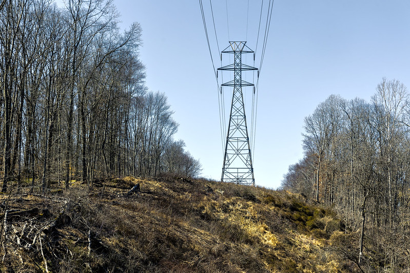
While scuttling along and kicking the dirt a bit, I once again became fascinated by a high tension electrical tower and the treeless corridor it occupied. I wonder how much it costs to manicure back the encroachment of forest on this multiple mile pathway. At any rate, I doubled back towards where I had parked the car and the spot on Peters Creek, flowing alongside the Corvette and Green Man’s Tunnel, which had piqued my interests.
Back tomorrow with some pix from Peters Creek.
“follow” me on Twitter- @newtownpentacle
Buy a book!
“In the Shadows at Newtown Creek,” an 88 page softcover 8.5×11 magazine format photo book by Mitch Waxman, is now on sale at blurb.com for $30.
Timberland Avenue
Friday

– photo by Mitch Waxman
Between 1970 and 1990, Pittsburgh lost 158,000 manufacturing jobs. That resulted in its population decline, which saw some 289,000 people move to greener pastures during the same interval. If you’re a wonk, and want to read graphs and a well thought out report on the demographic collapse of this area, check out this 2003 Carnegie Mellon Heinz School report on the situation. Observationally, and according to everything I’ve read on the subject, Pittsburgh has a lot of abandoned houses.
According to this article at pittsburghquarterly.com, Allegheny County alone has over 51,000 abandoned or blighted homes. Many solutions have been tried, including the Community Land Bank concept which my friends back in Queens and Brooklyn were very enthusiastic about. This is how that sort of scheme worked out here, unfortunately.
Combating “Blight” is a major budgetary spend for the municipal entities hereabouts. There’s all sorts of tales that are told about why somebody would abandon a property, but there are parts of Pittsburgh where every third or fourth house is abandoned. When you start getting out into the more rural areas, it’s common to see homes being overgrown by and reclaimed by the forests.

– photo by Mitch Waxman
Something very similar occurred in the 1970’s version of NYC I grew up in, when former industrial properties were being fenced off or abandoned, and the dormitory tenements which provided these businesses with staff began turning into crap holes and eventually got abandoned or burned out. Remember the South Bronx of the late 1970’s, both the South and North of Brooklyn, as well as the East River coast of Queens during the 1980’s. This is before the Gentrification Industrial Complex got started during the third term of Mayor Ed Koch (it all started over in Hells Kitchen and the Upper West Side, then the contagion spread to Brooklyn and Queens).
I always had the Millennials and Zennials who had recently arrived in NYC tell me that I had seen too many movies when I would describe packs of wild dogs roaming about the empty brick lots of 1980’s Williamsburg. I was there.

– photo by Mitch Waxman
These abandoned houses are divided from the surrounding area by Saw Mill Run, a tiny waterway discussed in yesterday’s post and which is pictured above and connected to other roads by a now closed bridge. The water looks fairly impure to me, and there’s lots of dumping that takes place along its banks – observationally.
As always, these photos always appear at Flickr before they get the write up here, and a Flickr commenter by the name of Lucien Van Elsen left me this great bit of research on what happened to these particular houses. As it turns out, they’re quite recently abandoned.
Here’s Lucien’s commentary, unedited.
“So, I wondered what the history was here… how did they get from someone’s house to this state? Going backwards…
Pittsburgh wanted to close the Timberland avenue bridge, since it only served these few houses. They were going to take it via eminent domain in 2020, but instead paid $70k for them, and left them in this abandoned state instead of knocking them down. Details in www.openbookpittsburgh.com/ContractDetail.aspx?ID=53308&a…
The houses were originally built around WWI, when the access was a wooden bridge:
historicpittsburgh.org/islandora/object/pitt:715.185345.CP
You can see some of these houses just after they were built, with well-dressed gentlemen crossing the bridge:
digital.library.pitt.edu/islandora/object/pitt%3A715.0914…
A good writeup on the backstory:
www.brooklineconnection.com/history/Building/Timberland.html”
Back next week with more from the Paris of Appalachia, at this – your Newtown Pentacle.
“follow” me on Twitter- @newtownpentacle
Buy a book!
“In the Shadows at Newtown Creek,” an 88 page softcover 8.5×11 magazine format photo book by Mitch Waxman, is now on sale at blurb.com for $30.
Saw Mill Run
Thursday

– photo by Mitch Waxman
A humble narrator found himself along an arterial roadway called Saw Mill Run Boulevard, after dropping off the recycling trash at a nearby municipal bin (they do cardboard, plastic, metals at the curb here but glass needs to be dumped in special places). The part of Pittsburgh I’m living in has a few high volume roads encircling it, which branch off into the various neighborhoods set into the hills and valleys that these high volume roads surround. These arterials eventually connect to a web of high volume and speed roads which move through the Pittsburgh region, many of which are interstate highways, as well as leading to the tunnels which feed traffic into the city center. For you New Yorkers – think Northern Blvd. or Eastern Parkway for an analogy.
Saw Mill Run Boulevard (part of Penn. Route 51) is one of these arterials, and there’s all sorts of commercial and light industrial activity happening along the length of it, as well as a constant flow of traffic. Saw Mill Run Blvd. travels through a shallow valley around the ‘South Hills’ which was formed by flowing water. Saw Mill Run Blvd. was officially created out of a couple of defunct railroad right of ways in 1928, and the investment was designed to compliment the connections to Downtown Pittsburgh which resulted from the opening of the Liberty Tunnel in 1924.

– photo by Mitch Waxman
Saw Mill Run is a tributary of the Ohio River, and is named for a colonial era saw mill that was found nearby the modern day community of West End, which used to be known as Temperanceville. There’s a little over 9 miles worth of flowing water in Saw Mill Run, and its drainage watershed is something like 19 square miles of fairly dense urban and suburban hills and valleys. Further expansions of Saw Mill Blvd. and Route 51 were encouraged and actually advocated for by NYC’s own Robert Moses, who was apparently able to get his way here in Pittsburgh back in 1949. Powerbroker, indeed.
Check out this 2017 post at gribblenation.org for the nitty gritty.

– photo by Mitch Waxman
Residential buildings, clearly abandoned ones, were observed on the other side of the Saw Mill Run waterway. A small bridge, which was blocked off with concrete barriers and a sign warning that the bridge was closed, offered a crossing over the water. You’ll see what I saw tomorrow.
Tomorrow – the consequence of Demographic Collapse.
“follow” me on Twitter- @newtownpentacle
Buy a book!
“In the Shadows at Newtown Creek,” an 88 page softcover 8.5×11 magazine format photo book by Mitch Waxman, is now on sale at blurb.com for $30.


