Archive for August 2015
pale vapors
Lower Manhattan’s FDR drive, in today’s post.

– photo by Mitch Waxman
Just prior to this shot of Manhattan’s FDR Drive being captured, a humble narrator had walked across the East River via the Williamsburg Bridge from the border of Greenpoint and Williamsburg at Meeker Avenue. One enjoyed a brief sit down and contemplation of the past at Corlears Hook park on Cherry Street before continuing on. Cherry Street on the East Side is one of those spots in NYC which is writ large in the historic record, and even Jacob Riis mentions it (during its degenerate period).
According to contemporaneous reports, the absolute worst tenements of the 19th century were not found at the famous Five Points but here at Cherry street. Additionally, a gang whose specialty was river piracy operated out of this area – they were called the Swamp Angels – and it’s because of their infamy that the NYPD ultimately created the Harbor Unit. After resting for a few minutes (it’s important to give your lower back an interval of downtime on a long walk, since it’s actually doing most of the work) I crossed one of the pedestrian bridges over the coastal parkway and entered “The House of Moses.”
from wikipedia
In 1785, the four-story mansion at 3 Cherry Street was leased by the Continental Congress to serve as the Executive Mansion for Richard Henry Lee, President of the Congress under the Articles of Confederation. It continued to serve as such for the next three Presidents and, in April and May 1789 served as the first Executive Mansion of the President of the United States and Mrs. Martha Washington.

– photo by Mitch Waxman
Another term of my own invention, “The House of Moses” is appropriately used when you find yourself on Borden Avenue in LIC, or Meeker Avenue in Greenpoint, in certain parts of Astoria, or even here along the East River coast of the Shining City itself. Wherever NYC’s master builder Robert Moses felt it was appropriate to eliminate vast swaths of residential or industrial real estate in order to make way for a high speed road (distinguished by zero grade crossings, mind you), you’re in the “The House of Moses.”
from wikipedia
Robert Moses (December 18, 1888 – July 29, 1981) was the “master builder” of mid-20th century New York City, Long Island, Rockland County, and Westchester County, New York. As the shaper of a modern city, he is sometimes compared to Baron Haussmann of Second Empire Paris, and was arguably one of the most polarizing figures in the history of urban planning in the United States. His decisions favoring highways over public transit helped create the modern suburbs of Long Island and influenced a generation of engineers, architects, and urban planners who spread his philosophies across the nation. One of his major contributions to urban planning was New York’s large parkway network.

– photo by Mitch Waxman
“The House of Moses” had a tendency to blight the areas surrounding it. The sections of Sunset Park and Red Hook which the Gowanus Expressway casts its shadow upon have never truly recovered, for instance. For generations, this East River waterfront was generally verboten to residents of surrounding communities, due to stink and crime. For most of my lifetime, this area was a de facto parking lot for Municipal employees, and a homeless camp. Ummm, ok – it is STILL both of those things, but there’s a lot less of the foreboding and sense of imminent doom or threat of arrest than there used to be.
The same process played out along the Hudson, and is currently underway on the western coast of a Long Island – the so called Brooklyn and Queens Greenways. The modern motivation for improving these littoral areas is that parks aid real estate development, of course.
from wikipedia
The East River waterfront in Lower Manhattan was known for heavy maritime activity, with over 40 piers in operation by the later 1950s. The busy waterfront provided easy access to New York Harbor and the Atlantic Ocean in the south, the Hudson River on the west, with a connection to the Erie Canal. However, the rise of truck traffic and the transfer of port activity to the Port Newark-Elizabeth Marine Terminal drastically reduced maritime traffic on the river after the middle 20th century. With many piers now defunct, ambitious plans have been made to reclaim and reuse the pier space. The north-south arterial highway, the FDR Drive, was moved to an elevated location to allow convenient access to the piers. In the 1970s, the Water Street Access Plan was drafted to extend the confines of the traditional Financial District eastward and create a new business corridor along Water Street, south of Fulton Street. Noting the success of the World Financial Center, the East Side Landing plan was created in the 1980s to add commercial and office buildings along the waterfront, again south of Fulton Street, similar to Battery Park City. This plan never materialized.

– photo by Mitch Waxman
The process is quite far along in the tony sections of Brooklyn’s Gold Coast like DUMBO and Williamsburg, as well as in Hunters Point. The eventual goal on that side of the East River will be a contiguous pathway which will allow you to walk or ride a bike through a modern residential corridor extending from Red Hook all the way to Astoria Park with just a few interruptions offered by obstacles like the Brooklyn Navy Yard, and certain unpleasantries – such NYCHA housing projects or Newtown Creek.
On the Manhattan side, the river walk currently extends (contiguously, I mean, as it does travel quite far north with interruptions) from 23rd street all the way south to Wall Street in the financial district and connects into Battery Park nearby the Staten Island Ferry.
Saying that, some sections of the promenade seem better used than others.
from nyc.gov
The East River waterfront has developed over the past 350 years as a central place in the city’s maritime history. The city began here, and as it grew and developed, the island expanded into the river. As population expanded, the city promoted the infill of waterfront lots to serve the growing demand for land in Lower Manhattan. As a result, the current shoreline is more than three city blocks from the original shore. The present location of Pearl Street is in fact the original East River shoreline of Lower Manhattan. As the city’s position as the premier port for trade on the east coast grew, so did the need for new piers to service the vessels coming and going out of the port. At its peak in the 1950’s there were over 40 piers along this two-mile stretch of waterfront; today there are fewer than 10 remaining.
With the decline in maritime activity over the past 40 years, various master plans have been developed for this waterfront. The Water Street Access Plan in the 1970’s envisioned Water Street as a commercial spine for modern office buildings and the expansion of the financial core. In the 1980’s, the plan for East River Landing, inspired by Battery Park City, proposed new office development on the waterfront south of Fulton Street. In the 1990’s, a new outpost for the Guggenheim Museum was proposed on the waterfront at the present location of piers 13 and 14 at the foot of Wall Street. Aside from some components of the Water Street Access Plan, none of these waterfront schemes have been realized to date.

– photo by Mitch Waxman
Part of the planning and construction offered to the 20th century by the “House of Moses” included not just highways but block after block of “slum clearance” projects. Hundreds of acres of walk up tenement buildings were razed to make room for apartment houses whose footprint could encompass an entire city block, something you see a lot of in the eastern section of Chinatown. These apartment complexes were financed and built using Federal monies that filtered through carefully chosen banks and insurance companies. His allies in finance and government were fiercely loyal to Robert Moses and urban renewal was how he paid them back. Author Robert Caro called Moses “The Power Broker.”
It’s fantastic that those days are long over, and there isn’t some moneyed clique of real estate, insurance, and construction interests that colludes with Government officialdom to displace and eradicate whole waterfront neighborhoods. That would be awful, wouldn’t it?
from wikipedia
Caro’s depiction of Moses’s life gives him full credit for his early achievements, showing, for example, how he conceived and created Jones Beach and the New York State Park system, but also shows how Moses’s desire for power came to be more important to him than his earlier dreams. Indeed, he is blamed for having destroyed more than a score of neighborhoods, by building 13 expressways across New York City and by building large urban renewal projects with little regard for the urban fabric or for human scale. Yet the author is more neutral in his central premise: the city would have been a very different place—maybe better, maybe worse—if Robert Moses had never existed. Other U.S. cities were doing the same thing as New York in the 1940s, 1950s, and 1960s. Boston, San Francisco and Seattle, for instance, each built highways straight through their downtown areas. The New York City architectural intelligentsia of the 1940s and 1950s, who largely believed in such prophets of the automobile as Le Corbusier and Mies van der Rohe, had supported Moses. Many other cities, like Newark, Chicago and St. Louis, also built massive, unattractive public housing projects.

– photo by Mitch Waxman
It’s actually in Chinatown where you’ll notice how thoroughly a community can embrace one of these waterfront esplanades installed by the House of Moses. Unfortunately, there are no signs installed by the State DEC cautioning against regular consumption of East River fish and crabs, and not once did I notice a bit of signage from the City DEP advising of the presence of a combined sewer outfall. Those pipes you’ll notice traveling down the supports of the FDR drive drain the elevated highway and feed directly into the East River.
Any who, that’s the House of Moses for ya.
from wikipedia
Large scale urban renewal projects in the US started in the interwar period. Prototype urban renewal projects include the design and construction of Central Park in New York and the 1909 Plan for Chicago by Daniel Burnham. Similarly, the efforts of Jacob Riis in advocating for the demolition of degraded areas of New York in the late 19th century was also formative. The redevelopment of large sections of New York City and New York State by Robert Moses between the 1930s and the 1970s was a notable and prominent example of urban redevelopment. Moses directed the construction of new bridges, highways, housing projects, and public parks. Moses was a controversial figure, both for his single-minded zeal and for its impact on New York City.
“follow” me on Twitter- @newtownpentacle
Upcoming Tours –
September 3rd, 2015
Newtown Creek Boat Tour
with Open House NY, click here for details and tickets.
September 20th, 2015
Glittering Realms Walking Tour
with Brooklyn Brainery, click here for details and tickets
attempt at
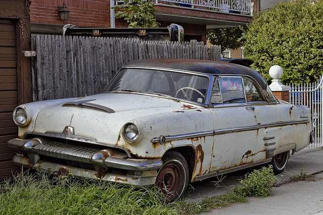
Cool Cars of Astoria, in today’s post.
– photo by Mitch Waxman
Wandering around the forbidden northern coast of Queens one day, a humble narrator happened across another one of those historic vehicles which are referred to at this – your Newtown Pentacle – as “Cool Cars” in Astoria.
As far as I’ve been able to discern – and as always – if I’m wrong, please correct my assertion – this is El Producto de Ford – a 1954 Mercury Monterey.
from wikipedia
The Mercury Monterey is a full-size car model that was introduced by Mercury in 1952. It would later share the same body style with the slightly more upscale Marquis, and the Park Lane and Montclair until the latter two were extinguished after the 1968 model year.

– photo by Mitch Waxman
It’s obviously well weathered, that’s for sure. This auto was parked alongside a series of one car garages and spotted around a block from Astoria Blvd. There’s a lot of similarity in body type and flashing to the Mercury Monterey Sun Valley, but this coupe has a hard top metal roof rather than the translucent plastic which the Sun Valley was offered with.
The Monterey model was a full-size near-luxury car introduced in 1950 and was the most expensive and luxurious vehicle in Mercury’s lineup. At the time General Motors and the Chrysler Corporation were producing a number of ‘hardtop convertibles’ and Ford was determined not to stand idly by as GM and Chrysler dominated the market with its attractive new pillarless coupes.

– photo by Mitch Waxman
Check out that space age design on the grill. Back then, gasoline was cheap, and tacking half a ton of extra weight onto the front of a car for the sake of ornamentation was no big deal. If you’ve never driven a car from this era, I can tell you that they are beasts.

– photo by Mitch Waxman
Cars like this 1954 Mercury Monterey lay heavily into turns, squeal their wheels, and when you step on the gas – it’s no modern differential gear smoothly driving the train – you get pressed back into your seat by zero to thirty in 3.4 seconds type acceleration. There are no lap and shoulder belts to hold you snugly in place while it’s happening, either. This model was built with a Y block V8 engine, which offered the coupe some 161 HP worth of juice.
Vroooooom!
“follow” me on Twitter- @newtownpentacle
Upcoming Tours –
September 3rd, 2015
Newtown Creek Boat Tour
with Open House NY, click here for details and tickets.
September 20th, 2015
Glittering Realms Walking Tour
with Brooklyn Brainery, click here for details and tickets
parched and terrible
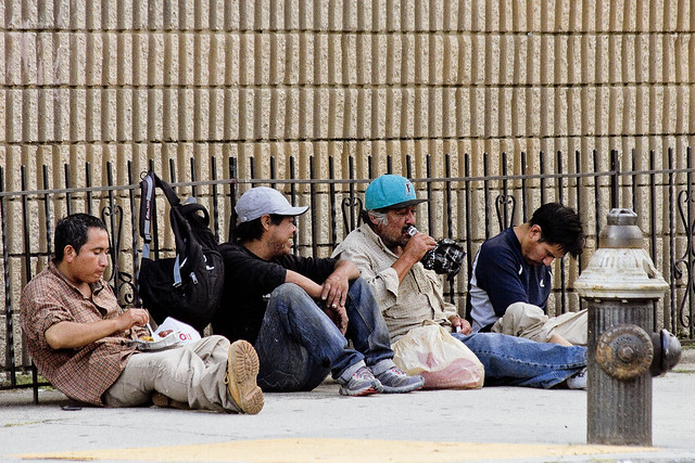
Hello 114th precinct, it’s me again.

– photo by Mitch Waxman
Since my last post on this subject, concerning “Los Borrachos” on Astoria’s Broadway, the 114th precinct has definitely been doing “something.” Can’t say exactly what, but the population of these alcoholic mendicants has been visibly reduced from the mid July high of 20-25 down to a late August bakers dozen. The shot above, and several of the ones following it, were gathered at the Times Square of Astoria – 42nd and Broadway – which is the central muster point that these fellows use, just last weekend.

– photo by Mitch Waxman
NYPD continues to inexplicably roll right past these guys, however. What sets me off, incidentally, and what has made these inebriates rise to the top of the list of “things I have to deal with” are reports from the ladies of Astoria as to the comments they are offered while passing by this crowd.
Even passing familiarity with the old “espanol” is enough to piece together sentences and phrases from the lingo which include “chupa” and “mi penga.” Sexual harassment of women walking down the streets by a drunken crowd of vagrants… is that OK?
– photo by Mitch Waxman
A Sunday afternoon, and public drinking is not challenged nor noticed by the cops. Everyone else in the neighborhood notices it, as people move to and fro with their children. If you’re curious, that’s Vodka that fellow is drinking.
Gordon’s Vodka to be precise, an assertion of brand loyalty which is based on the empty bottles littering the curbs along Broadway. The Times Square of Astoria indeed, only it seems to the Times Square of the 1980’s around these parts.
– photo by Mitch Waxman
The effects of the alcohol reduces these fellows to an insensate condition, regularly. For all of you “City Club head up your ass liberal” types who seldom walk the streets of New York – preferring your Uber or Limo for getting around – Progressivism isn’t about permissiveness. This is not something which Eleanor Roosevelt would have reacted to with any sort of empathy. John Lindsay or David Dinkins, on the other hand…
Don’t get me wrong here, I like a good tipple as much as the next guy – more so in fact. It’s the fact that this situation has gotten completely out of hand this summer, and whatever your intellectual notion is of who these guys are is completely fabricated from your own politics. These are bums, drunks, and hobos. We have a decent number of Homeless people here, who are referred to as “The Harmless.” Mostly down on their luck or mentally ill folks, Astoria takes care of its own – whether it’s just a slice of pizza or a bottle of water or a buck slipped into their palm.
The fellows showcased in these posts get off the R train, drink in the neighborhood all day, and then commute back to somewhere else if they can still keep it together enough to do so. If not, they just pass out on the sidewalk.

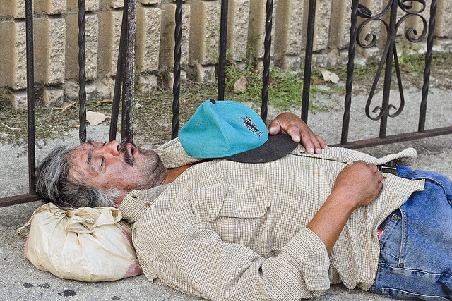
– photo by Mitch Waxman
Often, Astoria’s Broadway looks like a WW1 battlefield, with bodies arrayed haphazardly on the street. The shot above was from a Friday afternoon around 2. All that’s missing is a dead horse in the tree.

– photo by Mitch Waxman
A smoke condition down in the Subway drew the FDNY to the Times Square of Astoria last Sunday, whose actions and blaring sirens served to awaken the sleepers from their distillery dreams. Other units of FDNY would undoubtedly be back on the corner later, to scoop up the insensates. NYPD?

– photo by Mitch Waxman
Three in the afternoon on a Sunday.
The funny thing about this shot is that a friend of mine who works for the City spent years working on installing these Subway grate covers (intended to keep snow melt and storm water from infiltrating down to the tracks), which were specifically designed with the idea that they would be fairly impossible to sleep on.

– photo by Mitch Waxman
Notice that white car with the blue stripe just at the edge of the shot above?
Guess which uniformed and highly trained branch of City Government drives white cars with blue stripes. Why, 114th precinct, is this being allowed to continue? Do you really want the civilians in this neighborhood to be the ones to deal with this, as we currently are forced to? A day doesn’t go by when one of us is forced to shoo “Los Borrachos” off their stoop or out of a driveway. Often the only thing which will get them to move on is the threat of calling “La Policia.” The Police, however, seem reluctant to lance this boil.
“follow” me on Twitter- @newtownpentacle
Upcoming Tours –
September 3rd, 2015
Newtown Creek Boat Tour
with Open House NY, click here for details and tickets.
September 20th, 2015
Glittering Realms Walking Tour
with Brooklyn Brainery, click here for details and tickets
gleam and grin
Checking in on that little bit of construction occurring down in DUKBO.

– photo by Mitch Waxman
The Kosciuszko Bridge replacement project is in full swing these days, and there’s a small army of optic orange clad construction workers at work in that shallow valley between Laurel and Berlin Hills which has always provided a border betwixt LIC’s Blissville and West Maspeth’s Berlin neighborhoods. The old blue gray mare was built by the “House of Moses” back in 1939 as the “New Meeker Avenue Bridge,” carries the Brooklyn Queens Expressway over Newtown Creek, and is considered as being dangerously deficient from the structural integrity and the traffic engineering points of view – so the NYS DOT is overseeing the implementation of its replacement.
Nobody else seems to be paying any mind to this mega project, but a humble narrator is not at all like anybody else.

– photo by Mitch Waxman
These shots are all from the Queens side of the project, which will see the new bridge rise nearly one city block to the east of the 1939 model’s footprint. One has begun to refer to the street it will adjoin as “used to be 43rd street.” The shot above was captured on Laurel Hill Blvd., and depicts one of the many elevated piers which will carry the BQE towards its intersection with the Long Island Expressway.

– photo by Mitch Waxman
Closer to “used to be 43rd street” you’ll notice that the NYS DOT engineers have had the orange clad fellows jamming big bits of steel deep into Queens. The substrate which the bridge(s) sit upon is the elluvial flood plain of Newtown Creek – which is basically a giant agglutination of mud and aggregate. The piles need to be sunk down around one hundred and eight feet to meet bedrock, with the anchoring mechanisms for the piers going far deeper – from 160-180 feet depending on location.
Who can guess all there is, that might be buried down there?

– photo by Mitch Waxman
An unoccluded view of the metal bits, which are marked off with gauge measurement indications. This is the corner of “used to be 43rd street” and 54th avenue, for the curious.

– photo by Mitch Waxman
Same corner, but looking to the south rather than the antipode displayed in the former shot.

– photo by Mitch Waxman
The Skanska crews working on the site, who are the aforementioned “fellows dressed in orange,” have a disturbing habit of leaving their fences open – given the fact that the BQE continues to run along the span offered by the 1939 model Kosciuszko Bridge.
No big “whup” of course, as this section of the highway has never really been “secure” in any real manner and has been a target for graffiti and illegal dumping enthusiasts for multiple generations.

– photo by Mitch Waxman
The project continues along Laurel Hill Blvd. and includes the Kosciuszko Bridge approaches. The Meeker Avenue side of the approaches, which roll through Greenpoint and Williamsburg, have been receiving quite a bit of attention from the fellows in orange in recent months. The work on the Queens side is just getting started, in comparison.

– photo by Mitch Waxman
Phase One of the project will see the eastern half of the new bridge erected, followed by the dismantling of the 1939 era Kosciuszko Bridge. Traffic on the BQE will be rerouted onto the new span, and the construction on Phase Two will see the western section of the new bridge erected – whereupon traffic patterns on the BQE will be given their new and permanent form – with the eastern “Phase One” section carrying the South to North (Brooklyn to Queens) flow and the western “Phase Two” section allowing North to South (Queens to Brooklyn) traffic.
The good news is that Phase Two will include a pedestrian and bicycle path, which will overlook my beloved Newtown Creek.
“follow” me on Twitter- @newtownpentacle
Upcoming Tours –
September 3rd, 2015
Newtown Creek Boat Tour
with Open House NY, click here for details and tickets.
September 20th, 2015
Glittering Realms Walking Tour
with Brooklyn Brainery, click here for details and tickets
victoriously swept
If the bridge wasn’t there, it would be impossible to recognize Williamsburg, Brooklyn.

– photo by Mitch Waxman
Mephitic vapors, the effluent of furnaces and forges, a vague scent of molasses, and the smell of freshly smoked crack cocaine used to be all you needed to recognize where you were when visiting Williamsburg. These days, all you’ve got is the visual cue offered by its eponymous bridge and the vague scent of high end Marijuana.
Occasion found me in the ancient village, and as I was headed for Manhattan to meet up with a boat later in the day, a scuttle across the bridge was called for.

– photo by Mitch Waxman
A lot of people think this span is an architectural travesty, but I’ve never thought it was bad enough to to create a Municipal Arts Society over. There are “separate” pedestrian and bicycle paths, which aren’t really segregated from each other in any cohesive manner, but as one such as myself enjoys playing things “by the rules” – I found myself climbing the surprisingly steep ramp leading up from Brooklyn to the bridge itself. At least it provides for some fairly good “cardio.”

– photo by Mitch Waxman
Back in art school, the conventional wisdom imparted to me by a generation of instructors was that you can’t go wrong when there’s an umbrella in your shot. The reasoning is that the umbrella is an inherently interesting shape, and it breaks up the otherwise pedestrian points of view one normally encounters. It wasn’t raining, of course, and the umbrella was simply there to shield its wielder from the particularly powerful emanations of the burning thermonuclear eye of God itself whose gaze seemed fixed upon the bridge.

– photo by Mitch Waxman
All the tourists seem to flock to the Brooklyn Bridge, and its pedestrian path offers one a frustrating and crowded experience. It’s a bit like a lunch line at a buffet, that walk, a slow shuffle while trapped in a queue. Vast preference for the less popular bridges like Queensboro, Williamsburg, and Manhattan is offered by your humble narrator. Crowds suck.

– photo by Mitch Waxman
For this walk, I used my “crappy lens” – a 70-300 consumer level zoom. After the great camera disaster of July, wherein both camera body and my “best lens” were destroyed, I’ve been making it a point of mixing things up a bit. Thanks to many of you who donated money for replacement equipment to this blog, and both body and “best lens” have been replaced. Regardless, one tries to keep things fresh and the extra reach which the imperfect but serviceable “long lens” provides for slightly different perspectives and color rendition.

– photo by Mitch Waxman
It would be utterly pedantic to go into the technical details on this subject, so suffice to say that each and every lens interprets the light moving through it in different ways. Certain lenses are great for portraits, others for landscapes. Camera settings can also affect color rendition as well – for instance, narrow apertures render the color blue in a certain way due to the clipping of upper and lower limits found in the blue light wave.
As I said, technical and pedantic.

– photo by Mitch Waxman
Manhattan side of the Williamsburg Bridge, at Delancey Street, and looking back towards the infinity of Brooklyn.
The Williamsburg Bridge is 7,308 feet long (measuring between the cable anchor terminals) and the deck is some 118 feet wide. The height at the center of the bridge is 135 feet and each tower is 310 feet in height as measured from the East River’s high-water mark. It was originally called East River Bridge #3 when opened in 1903. Its architect was Henry Hornbostel, and the chief engineer who oversaw its construction was Leffert L. Buck.
“follow” me on Twitter- @newtownpentacle
Upcoming Tours –
September 3rd, 2015
Newtown Creek Boat Tour
with Open House NY, click here for details and tickets.


