Archive for May 2023
Old fashioned
Wednesday
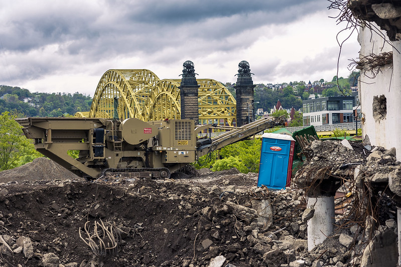
– photo by Mitch Waxman
That Porta Potty in the shot above might actually be a Tardis, used by a Time Lord like Doctor Who to travel through time and space. At least that’s what it looks like to me. The rubble used to be a cold storage warehouse which is in the process of demolishment, but there’s a stoppage at the site currently since the process has destabilized buildings on neighboring lots. Guess what they’re going to build here? Yup, ‘affordable housing.’
After the Doors Open tour we attended, which allowed us access to a few amazing spots including two very interesting Roman Catholic Churches, it was time to head home. Our Lady of the Pentacle and myself had left the Mobile Oppression Platform (the Toyota) back at HQ and were traveling ‘to and from’ using the T Light Rail system.

– photo by Mitch Waxman
After negotiating our way on foot to one of the T stations in Downtown Pittsburgh, we had about a 15 minute interval to wait before we boarded. The T runs off a catenary wire when it’s outside, but I think it uses a third rail shoe underground. The service is fairly frequent, even on the weekends, and there are multiple lines. It costs $2.75 to get back and forth from HQ.
Seriously, I’m absolutely loving having a car, especially one with a hybrid engine that regularly clocks in at 39 mpg while I’m living in a City where ‘all day parking’ costs something between $6 and $9, but there are days when I’d rather cut my head off than drive. The availability of transit is one of the factors that drove our choice of location regarding HQ here in Pittsburgh.

– photo by Mitch Waxman
That’s the Red Line T arriving at the station. Notice the absence of garbage on the tracks, the lack of graffiti, and that nothing is dripping mystery sludge onto the platforms, and also the complete absence of pizza rats. Old ladies sat on a bench chatting while waiting for their train, without a care in the world. Nobody’s head was ‘on a swivel,’ except mine.
I used to always refer to NYC as ‘Home Sweet Hell’ in a joking matter. I don’t smile anymore when saying that.
Back tomorrow.
“follow” me on Twitter- @newtownpentacle
Buy a book!
“In the Shadows at Newtown Creek,” an 88 page softcover 8.5×11 magazine format photo book by Mitch Waxman, is now on sale at blurb.com for $30.
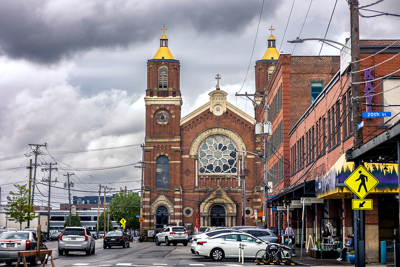
St. Patrick R.C. Church
Tuesday
– photo by Mitch Waxman
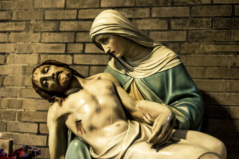
A few blocks away from St. Stanislaus Kostka Roman Catholic Church, which Our Lady of the Pentacle and myself got to visit on a walking tour of Pittsburgh’s Strip District offered by the ‘Doors Open Pittsburgh’ organization, is another church called St. Patrick’s. It has an interesting history, one which is detailed at this site.
I was struck, while our guide was describing the place to us, by the accoutrements. Sculpture and stained glass were everywhere, as were several oil paintings of important former Vicars and Priests. The Pieta pictured above was particularly well sculpted, in my opinion.
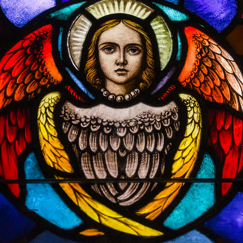
– photo by Mitch Waxman
I once did a comic that involved the Angels, using Sammael/Lucifer and Michael to fight back an analogous form of Cthulhu, but I interpreted them through a superheroic and pop cultural lens. I’m thinking that’s the Archangel Michael pictured above, as interpreted in the form of stained glass. Patrick is one of the Saints I’ve never seen rendered up like a medieval soldier with wings, which is conventionally how you see Gabriel or Metatron or Michael represented, instead it’s mostly bishop or monk robes for him. The rendering above is a bit more ‘Bible compliant’ than most of the Catholic art related to the Sons of Fire (men are the Sons of Clay), with the multiple sets of wings set into a roundish shape. Read the Book of Ezekiel if you want to know more about that description of God’s Squad.
If this Angel business is a topic that you have any sort of scholarly interest in, there’s an amazing set of books by a fellow named Jeffrey Burton Russell which explores the development of Christian philosophy from prehistoric times into the modern era. The conceit used is eminently Zoroastrian in nature – as in you cannot perceive the light without studying the shadows – so Russell focused in on what individual cultures during the various eras described as being tempting evil to discern what heights they aspired to instead. Russell’s bibliography includes ‘Satan: The Early Christian Tradition (1981),’ ‘Lucifer: The Devil in the Middle Ages (1984),’ ‘Mephistopheles: The Devil in the Modern World (1986)’ and others. Fully footnoted in both Latin and Greek, I would mention. Great stuff.
– photo by Mitch Waxman
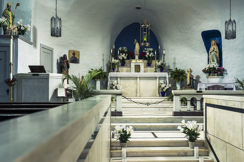
The stairs at the bottom of the shot above are a ‘Scala Sancta’ or Holy Stairs, which congregants are meant to ascend only on their knees. This is the ‘sacred space’ chapel area, which is remarkable for its unadorned and plain nature. Normally, Catholic spaces I’ve visited in the United States are more like St. Stanislaus Kostka – ornate and somewhat baroque with paintings and sculptures everywhere. This sort of chapel reminds me of small village churches I’ve seen in Europe.
Back tomorrow.
“follow” me on Twitter- @newtownpentacle
Buy a book!
“In the Shadows at Newtown Creek,” an 88 page softcover 8.5×11 magazine format photo book by Mitch Waxman, is now on sale at blurb.com for $30.
St. Stanislaus Kostka R. C. Church
Monday
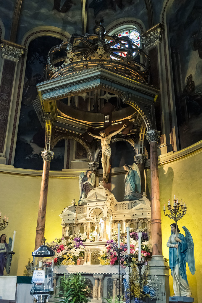
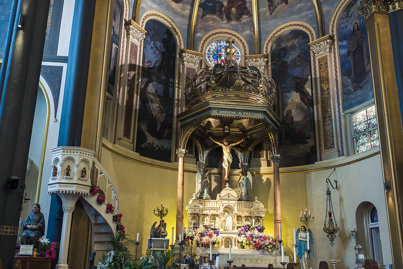
– photo by Mitch Waxman
That’s the… what do you Goyem call it… altar? The stage? I don’t know, but it’s the centerpiece and point of focus at Pittsburgh’s St. Stanislaus Kostka Roman Catholic Church. My grandmother would have referred to the statuary depicting the crucified Christ rising above a scale model of Rome’s St. Peter’s Basilica at the Vatican simply as “Yuyzel on da cruss.” What can I tell you, I grew up Jewish.
I’ve visited this ‘sacred space’ before, but this time around I was on a walking tour of the surrounding strip district offered by the ‘Doors Open Pittsburgh’ outfit and I got to linger and take a really good look at the place.
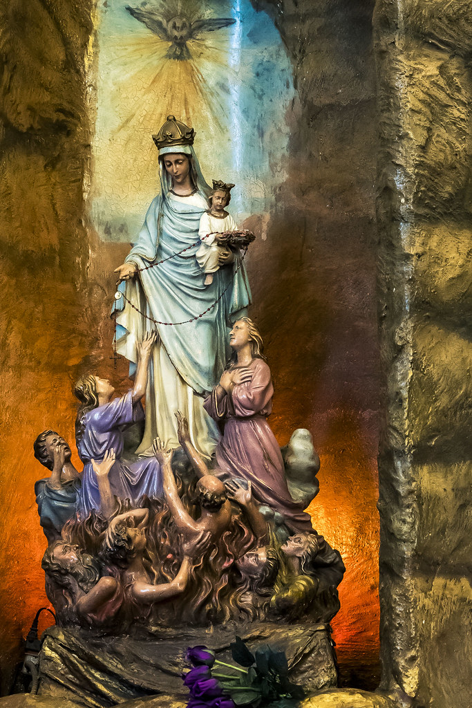
– photo by Mitch Waxman
This sculpture caught my attention just because there’s so much going on in the composition. Whom I would presume to be Mary is holding a baby I would presume to be Jesus, and offering the Rosary to the damned. I’m sure that every hand posture and facial expression has some allegorical meaning, as that would be ‘very Catholic.’ It was located behind the rack of votive candles, if that means anything. It probably does.
One of the Lay people who care for the church spoke to our group of lookie loos and detailed the history of the centuried congregation and it’s many trials that have included catastrophic floods and nearby industrial explosions. I couldn’t get a decent shot of the mural on the ceiling vault, which depicts John Sobieski and the boys arriving in Vienna to kick some Turk ass. For those not familiar with the battle, it’s what Tolkien based the ‘Charge of the Rohirim’ at Helms Deep on in his Lord of the Rings epic.
– photo by Mitch Waxman
On our way back out to the street, and we had to leave in an expeditious fashion as the Church’s Priest had appeared in vestment, with a large family in tow and they were preparing to christen a new baby. If you’re ever in Pittsburgh, definitely put this jewel of a church on you list to visit. Pope John Paul 2 did, so why not you?
As a note, I’ve actually done a bit of research on the ritual of Baptism in the past and it is positively ancient. The Canaanites were basically fire worshippers, being connected to the religions of the Phoenicians as they were – with Baal as the central godhead and ritual sites found on the hilltops in wilderness areas – so it’s unlikely that the proto Hebrews picked it up from them. Theoretically, Baptism became part of the portfolio about the same time that Angels first became part of the story, during the ‘Babylonian Captivity.’
Back tomorrow.
“follow” me on Twitter- @newtownpentacle
Buy a book!
“In the Shadows at Newtown Creek,” an 88 page softcover 8.5×11 magazine format photo book by Mitch Waxman, is now on sale at blurb.com for $30.
The very air
Friday
– photo by Mitch Waxman
The light is very different here in Pittsburgh, with its river valley atmospherics, than the skies that I used to experience back in the oceanic climes of NYC. It’s been mentioned a few times here, the volatility and changeability of Pittsburgh’s weather. Apparently, it’s the interaction between the flat plains of Ohio and Pittsburgh’s location in the foothills of the Appalachian range, coupled with the corduroy riverine terrain which generates the dynamics above. It could be gray, then raining, then bright sun, and then overcast again all within a couple of hours.
Observationally, Pittsburgh’s specific location is one that causes most of the truly severe weather just blow around it (so, meteorological kudos to George Washington). 50 miles north or south, they’re getting blasted with snow or even tornadoes, and in Pittsburgh it’s just drizzling. I’ve apparently gotten lucky in terms of the move, as this year had a mild enough winter that the TV news meteorologist people have commented on it.
– photo by Mitch Waxman
Thing is, and you may have noticed this in the last few months, is that the sky here is a distinct part of the setting, so I’ve been making it a point of exposing the images in a manner designed to capture the circumstance. Back in NYC, if you wanted to ‘place’ an image it was just a matter of getting a landmark like the Empire State Building in it and no matter what the subject was, the visual subtext indicated ‘NYC.’
I’m working under the theory right now that Pittsburgh’s ‘Empire State Building’ which ‘sets the place’ is the sky itself, with its dynamic stacks of clouds and omnipresent turbulence. When we first moved here, one of the new neighbors advised that Vitamin D supplements would be advisable, given that on average – 2 out of every 3 days in the Pittsburgh region are at least partially overcast. The locals complain about experiencing ‘SAD’ or ‘Seasonal Affective Disorder’ due to a lack of radiate exposure to the burning thermonuclear eye of god itself, and that these supplements help vouchsafe one against the phenomena.

– photo by Mitch Waxman
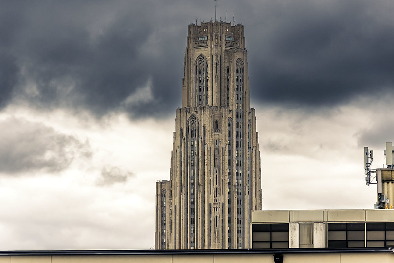
In general, you’re a lot closer to the sky in this part of the country than you are down on the coastline. The first shot in today’s post depicts UPITT’S Cathedral of Learning in the Oakland section, the second is from the Strip District along the Allegheny River, and the one above was captured while onboard a boat navigating the Monongahela River during a period of fairly heavy rain.
In all three shots, what caught my eye was the sky vault itself, rather than the arrangements along the ground. I don’t know, maybe it’s my imagination. Is any of this real? Where am I? Maybe I’m on a ventilator somewhere and this is all just some fantasy that’s playing out while my brain is dying. Who can tell?
Back next week with more.
“follow” me on Twitter- @newtownpentacle
Buy a book!
“In the Shadows at Newtown Creek,” an 88 page softcover 8.5×11 magazine format photo book by Mitch Waxman, is now on sale at blurb.com for $30.
I miss my Tonka trucks
Thursday

– photo by Mitch Waxman
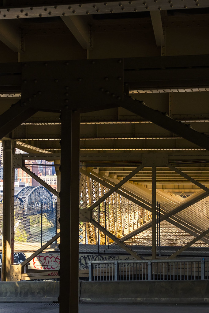
Ok, one more from that long walk, an ‘odds and ends’ post. While walking off Pittsburgh’s Liberty Bridge towards the T Light Rail and my ride back to HQ, I noticed that the action at the concrete factory below me had ceased operations for the day and their equipment was sitting there lit up all pretty like by the burning thermonuclear eye of god itself. Couldn’t resist.

– photo by Mitch Waxman
Wouldn’t it be great to have a crane as your second car? Easy to park, when you think about it, a crane is. If you can’t find a spot, you can make one by hoisting somebody else’s wheels out of the way.
– photo by Mitch Waxman
Just as I was walking over to the T to get back to HQ, the light began to bounce around inside the steel of the Liberty Bridge which I had just walked over. Fun walk, this one was.
Back tomorrow.
“follow” me on Twitter- @newtownpentacle
Buy a book!
“In the Shadows at Newtown Creek,” an 88 page softcover 8.5×11 magazine format photo book by Mitch Waxman, is now on sale at blurb.com for $30.


