Archive for June 2017
cellular corruption
It’s National Mai Tai day, in these United States.

– photo by Mitch Waxman
Increasingly, one realizes the depths of his personal ignorance about common things. Whilst watching, lovingly, my little dog Zuzu sleeping the other night it occurred to me that I didn’t know very much about Dogs from a scientific point of view. This led me directly into a “Wikipedia rabbit hole” during which canid evolution and its various family trees were explored, and soon it was 3:30 in the morning. This is an occupational hazard for the curious.
The next morning, I continued my reading on the Canids of the Holocene era, which led me to the Oligocene and the root ancestry of the Carnivora mammals. Moving forward instead of back in time, I soon found myself reading about the Hyena family, which somehow led to me watching videos of wild animals fighting. It was decided to end my explorations after witnessing a battle between a Hippo and a Rhino. The Hippo won, which was sort of unexpected but there you go.
I was able to control myself and avoid searching for “Tiger versus Hippo” as it might shatter a preconception I have which states that nothing can beat a Tiger in claw on claw combat, with the notable exception of a Russian. Russians and Tigers are probably the toughest bastards on the planet in terms of pure survival skills, IMHO, and long have I argued for the preservation of both specie just in case we are ever invaded by an extraterrestrial civilization.

– photo by Mitch Waxman
It would be unexpected, I realize, for some space faring race of conquerors to suddenly find themselves beset by Russian Spetnatz troops riding militarized Siberian tigers. Supposition began to reign, and it occurred to me that the “tough guy” cultures of the Earth – all the tribes of man – would probably lend a unit of paired human and animal predators to the battle for earth. Maori riding rocket propelled tiger sharks in zero gravity, Inuit riding Polar Bears… the mind boggles when imagining units of French Dauphine commandos or Apache wolf riders. Vietnamese guerillas mounted on giant centipedes or Mekong Catfish, Polynesian Frogmen and their cephalopod partners, Bantu special forces with their Hippo armies – the mind boggles.
With the right inducement, we could probably create whole divisions of animalia who would require no human partner at all. It’s their planet too. Imagine units of angry Chimpanzees in space helmets suddenly introduced into the confines of a spacecraft. Chimps are ghastly and powerful warriors.
You don’t mess around with Chimps, as a note, as they’ll eat your face and twist off your junk just for shits and giggles.

– photo by Mitch Waxman
A little known fact about Western Queens is that when the Europeans arrived here, Maspeth in particular, but all of the East River coastline was infested with wolves. It was likely the so called “Red Wolf” which was well established on the eastern coast of North America. The Dutch, and later the English, offered bounties to the populace for wolf pelts in pursuance of exterminating the predators which poached from the European farmer’s livestock.
According to my readings, entered into after watching Zuzu the dog snoring away in a corner of the living room, modern day wolves and dogs are both descended from a common ancestor which was far larger and more vicious than anything walking the earth today – a critter adapted for taking down the megafauna of the Ice Age. Who knew?
Happy July 4th weekend, lords and ladies, back on Monday with something completely different at this – your Newtown Pentacle.
“follow” me on Twitter- @newtownpentacle
sterner things
It’s National Bomb Pop Day, in these United States.

– photo by Mitch Waxman
As described in yesterday’s post, a hurried flight from “Point A” in Astoria to “Point B” in Brooklyn’s Greenpoint section was enacted last Saturday, in order to arrive on time for a walk through and discussion of the NYC DOT’s Kosciuszcko Bridge project’s commitment to create new parkland in the post facto footprint of their construction zone. Invitees were community members, folks from Open Space Alliance, NYC Parks Department, and a few local busybodies such as myself.
That’s Robert Adams, of the New York State Department of Transportation, chief engineer and showrunner for the K Bridge replacement project.

– photo by Mitch Waxman
I’ve stated many times that the community communications side of this project has been extraordinary. I’ve also reported to a number of people that Mr. Adams, in particular, has been remarkably transparent and amiable to receiving input from those who surround the perimeter of his project. Gold standard, in my experience, as far as handling the impact of a large scale public works projects in the crowded urban industrial setting of Newtown Creek in North Brooklyn and Western Queens. Kudos.

– photo by Mitch Waxman
As has become familiar – when visiting the K Bridge job site – our little group donned “Personal Protective Equipment,” which included safety glasses, gloves, orange vests, and hard hats. That paved sidewalk, on the left of the shot above adjoining the retaining wall for the Brooklyn Queens Expressway’s Meeker Avenue onramp, is “used to be Cherry Street.” The street we were walking down, in a northerly direction heading towards Scott Avenue, is nouveau Cherry Street.
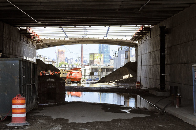
– photo by Mitch Waxman
That’s the new overpass at Varick Avenue, looking westwards towards the East River.
Documenting this project has been a long standing project of mine – this 2012 post tells you everything you could want to know about Robert Moses, Fiorella LaGuardia, and the origins of the 1939 model Kosciuszko Bridge. Just before construction started, I swept through both the Brooklyn and Queens sides of Newtown Creek in the area I call “DUKBO” – Down Under the Kosciuszko Bridge Onramp. Here’s a 2014 post, and another, showing what things used to look like on the Brooklyn side, and one dating back to 2010, and from 2012 discussing the Queens side – this. Construction started, and this 2014 post offers a look at things. There’s shots from the water of Newtown Creek, in this June 2015 post, and in this September 2015 post, which shows the bridge support towers rising. Additionally, this post from March of 2016 detailed the action on the Queens side. Most recently, here’s one from May of 2016, and one from June of the same year. Here’s one from August of 2016, the December 2016 one, one from March of 2017 which discusses the demolition of the 1939 bridge.
Most recently – a post showing what I saw during a pre opening walk through in early April of 2017, and the fanfare surrounding the opening of half of the new bridge in April of 2017.

– photo by Mitch Waxman
Just shy of Gardner Avenue, currently a closed off section of the construction site, Mr. Adams began to discuss the perimeter of the new park. It will quite literally be in DUKBO, Down Under the Kosciuszcko Bridge Onramp. The site will occupy a mostly paved area largely shadowed by the two new bridges. Our group discussed the possibility of shade tolerant plants, and or harvesting “gray water” from the highways to feed into planting beds.
The problem with that, as stated by somebody from Parks Dept. was this – shade tolerant plants are seldom salt resistant and that even without harvesting runoff from the BQE’s drains, there’s going to be a considerable amount of road salting during the winter months both above and below the parcel.

– photo by Mitch Waxman
The demolition of the old bridge is going to be occurring shortly, which will play out in two stages. First is the removal of the central truss section, then the “energetic demolition” of the approaches. If the schedule holds true, the second half of the new K Bridge will open in 2020 standing in the footprint of the old one.
That’s when the parks business will begin in earnest. There’s a section on the Maspeth side, on 43rd street, in Queens. Another section is this parcel in Brooklyn, and the old Sgt. Dougherty park on Meeker avenue at Chery Street is going to be redesigned and rebuilt.

– photo by Mitch Waxman
One of the interjections a humble narrator offered, as one who knows this zone intimately enough to refer to it affectionately as the “Poison Cauldron of the Newtown Creek,” involved the intended pathways which people from the surrounding neighborhoods would use to get here. The surrounding areas to the east and south are insanely dangerous, traffic wise, with gargantuan trucks whizzing about and all sorts of blue collar people doing blue collar things. Warehouses, waste transfer stations, truck and bus mechanics… not to mention all of the autos at Meeker Avenue angrily straining to get into the approach lanes for the BQE.
In short, way finding and traffic control.

– photo by Mitch Waxman
About those waste transfer stations… one of the things that makes this particular “cauldron” so “poison” is the tonnage of putrescent – or black bag – garbage transported here daily. This section of DUKBO is covered in quite toxic dust. Harvesting a booger from your nasal cavity after a walk through this section will reveal many things to you about the quality of air and suspended particulates. There’s also the smell.
DUKBO stinks of decay, rot, and hot garbage. On humid days, you will notice swirls of diesel exhaust along with shiny specks of dust hanging in the ether, as illuminated by an odd shaft of light. In short – dust and odor control are essential.
The choice of this area is an extremely challenging one for a park, but given the paucity of parkland in North Brooklyn – beggars can’t be choosers and you have to work with what you’ve been given.

– photo by Mitch Waxman
As far as the construction progress side of things, as mentioned, DOT and their contractor’s efforts are now being focused on the removal of the 1939 era Kosciuszcko Bridge. Up top, traffic has long been rerouted onto the easterly half of the new span, and torch bearing demolitionists have been cutting up small sections of the old bridge. The former walkway and the side railing has been cut up and will be sent off for recycling.

– photo by Mitch Waxman
Above Newtown Creek, but below the BQE, crews are assembling the “strand jacks” which will lower the central truss down to a waiting barge. The steel of the central truss is also meant to be recycled, and will be making a final journey to New Jersey escorted by tugs sometime during the coming month.

– photo by Mitch Waxman
This is the view from Scott Avenue, and the new park will continue down to the bulkheads and will overlook the water, I’m told. There has been some discussion of waterfront access here, as in a place where you’d be able to put a boat in the water, but one hasn’t been a part of that conversation.

– photo by Mitch Waxman
Walking back, as we crossed Gardiner Avenue, I handed off my “PPE” to Mr. Adams and bid the group adieux rather than go all the way back to Meeker and Varick Avenues where we had met up.
I headed down instead to the site of the first Meeker Avenue, or Penny Bridge. Once upon a time there was a swing bridge on Newtown Creek which connected Brooklyn’s Meeker Avenue with Queens’ Review Avenue (and the Penny Bridge LIRR stop). Penny Bridge was demolished in 1939 when the new Meeker Avenue Bridge opened (renamed as Kosciuszcko in 1940) but the masonry on both sides of Newtown Creek are still present.
It was a neat idea, I thought, visiting all three Meeker Avenue Bridges in the same day.
History nerd here, what can I tell ‘ya?

– photo by Mitch Waxman
While I was at Penny Bridge, my zoom lens was dialed to its extant focal length and I zeroed in on the Queens side’s strand jacks being erected. Hey, I may be a history nerd, but I know for a fact that several of you out there are engineering nerds.
Upcoming Tours and events
Newtown Creek, Greenpoint to Hunters Point, walking tour with NYCH2O – June 29th, 7-9 p.m..
Experience and learn the history of the western side of Newtown Creek, as well as the East River Parks Hunters Point with NCA Historian Mitch Waxman – details here.
“follow” me on Twitter- @newtownpentacle
resonant profanity
It’s National Ceviche Day, in these United States.

– photo by Mitch Waxman
“I’m late, I’m late, For a very important date. No time to say “Hello, Goodbye”. I’m late, I’m late, I’m late” is what was going through a humble narrator’s brain box last Saturday morning. Often is Lewis Carroll psychically conjured on my way to Newtown Creek, a place which is the very definition of “through the looking glass” for one such as myself.
Accordingly, a vehicular coach was summoned via the LYFT application found on my pocket telecommunications device, which automotively conveyed one to the poison cauldron of the Newtown Creek in Greenpoint. The driver, following the directions offered by a computer program on his own pocket telecommunications terminal, used the Brooklyn Queens Expressway for the trip. For once, rolling the dice on the BQE paid off and it was a quick journey between “Point A” in Astoria and “Point B” in Brooklyn.

– photo by Mitch Waxman
We crossed the lugubrious Newtown Creek on the sparkling new 2017 model Kosciuszcko Bridge, with the 1939 version just to the west. As one such as myself cannot turn down an opportunity to record and catalog any and all visual experiences encountered in the City of Greater New York, the camera was being waved around in the back seat as the driver performed his particular function in the front.

– photo by Mitch Waxman
The NYS DOT is currently working on the dismantling of the 1939 version, which is at an early stage. Newtown Creek Alliance has recently prepared and propagated a post describing what we know about the various stages, scheduling, and status of the demolition project for the so called “K Bridge,” and it can be accessed here.

– photo by Mitch Waxman
You may recall that I was up here for opening day of the new bridge back in April, but that was on foot. Dedicated pedestrian that I am, it’s an odd thing to actually be riding in an “auto-mobile,” but since I had experienced a fairly late night the evening before – one had risen later than planned and there was no way that I was going to get to Brooklyn from Astoria on time via perambulatory means.
I’m actually obsessed with being “on time” and am particularly keen on “being early” for events and meetings. It’s kind of a “thing” with me. My parents always insisted that you arrive early to appointments, as that’s at least one thing that the people you’re going to see can’t hold against you. Mom always said “you can’t do anything about being ugly, stupid, ungrateful, and unlikeable but at least you can be early.” I’m all ‘effed up.

– photo by Mitch Waxman
This wasn’t a tour, per se, as in one I was conducting of the area which I’ve long referred to as “DUKBO” or Down Under the Kosciuszcko Bridge Onramp.” Instead, the NYS DOT is in the early stages of planning two parks – one in Queens and one here in Brooklyn. They called together members of the K Bridge Stakeholders Advisory Committee (I’m on that one) and the Brooklyn Parks group “Open Space Alliance,” or OSA, to discuss the space and begin the process of planning.
I showed up wearing my Newtown Creek Alliance hat, but since we were going to enter the job site, it was soon replaced by a hard hat that said “Skanska.”
– photo by Mitch Waxman
My LYFT driver was instructed by both myself and the computer program on his pocket computer terminal to exit the BQE at the Meeker avenue stop, which was terribly exciting for one such as myself as I’m a “creek geek.”
Kept on thinking about that white rabbit, me. It was nearly the time for the meetup with DOT and OSA, and I’d still have to walk a block or two to the location.

– photo by Mitch Waxman
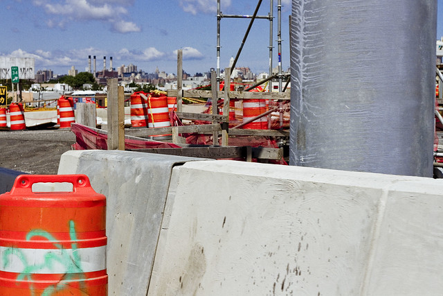
That’s the east side of Meeker Avenue pictured above, with its newly constructed on-ramps and approach roadways feeding traffic from Brooklyn into Queens. It’s been so chaotic in this area for the last few years, what with the construction and all, that it was quite a relief to see a bit of calm inserted back into DUKBO.

– photo by Mitch Waxman
Saying that, there was still quite a hullabaloo going on in DUKBO.
The demolition of the 1939 bridge will be the supreme focus of all the concerned parties for the next several months, but for right now the teams of contractors and union hard hats are making busy with repaving local roads and improving the subterranean infrastructure (sewers, drains etc.) that serve the new bridge. I know the folks who live in the house that that backhoe is working in front of, who are… shall we just say… anxious for the project to conclude.
Tomorrow, I’ll show you what I saw whilst wearing the hard hat in DUKBO.
Upcoming Tours and events
Newtown Creek, Greenpoint to Hunters Point, walking tour with NYCH2O – June 29th, 7-9 p.m..
Experience and learn the history of the western side of Newtown Creek, as well as the East River Parks Hunters Point with NCA Historian Mitch Waxman – details here.
“follow” me on Twitter- @newtownpentacle
tentative measures
It’s National Orange Blossom Day, in these United States.

– photo by Mitch Waxman
Another day, another commute. One’s life is odd, and each day brings its own sort of challenge.
I didn’t have any paying work one recent weekday, so when a Manhattan based anti gentrification activist emailed and asked if he could meet up with me to discuss the DEP and their CSO’s in Greenpoint and LIC… well, how could I say no to something like that? We met at Dorians in LIC, I had a cheeseburger and a cup of black coffee. On the way home, I had to stop off in Sunnyside to see a guy about a thing, so I hopped on the 7 across the street from Dorians at Vernon/Jackson.
As a note, I sometimes use “Vernon Jackson” as an alias.

– photo by Mitch Waxman
I’m trying to come up with a term to replace “gentrification” at the moment, as I don’t think it’s apropo to describe what’s happening in Long Island City and the East River coastline of Brooklyn (et al) in modern times. According to the dictionary people, gentrification is defined as – “the process of renewal and rebuilding accompanying the influx of middle-class or affluent people into deteriorating areas that often displaces poorer residents.”
That’s not what’s happening in Long Island City. At all.
Gentrification is something that “happened” in East Harlem and the Upper West Side, Bushwick and Williamsburg and Park Slope, but back in the 1990’s. What’s going on now… we don’t have a name for it, yet. Longtime Newtown Pentacle commenter and reader “Cav” has suggested “development rampage.”

– photo by Mitch Waxman
Now, let me qualify my statements with this – unlike normal people, I don’t exactly have “feelings.” Rather, and especially when behind the camera, I try to be some sort of extraterrestrial thing recording the antics of you drunken man beasts in a quite separated, sterile, and utterly emotionless manner. When not shooting, I don’t run around waving signs, chanting chants, or spouting sophomoric “poli-sci” nonsense about “the youth” or “verbal activists.” If I need to get something done, or fixed, I “show up” and get involved in the process of fixing it.
I don’t think that what’s in your pockets is somehow mine by natural right, and I wouldn’t dream of telling you what to do or not do with your own property. Like most Americans, I want to be left alone to mind my own business without input from you, the government, or anybody else.
Saying all that, I may not like what you do with your personal property, but just as I would insist regarding my own “stuff” – it’s none of my business what you do. Key word in that statement is “business.”

– photo by Mitch Waxman
It always pisses off the officialdom types when I refer to “my property” and question them about their stewardship or management thereof. A good political operator working for the Government will respond positively to me when I refer to them as “my employees,” whereas others will sneer at me and adopt a tired expression. When we’re talking about Sunnyside Yards, that’s the very definition of “our collective property,” however. Amtrak and MTA don’t own the yards, the public does, and the two agencies are meant to represent our collective interests. The only part of the yards which are in private hands is on the 43rd street side, and it’s owned by General Motors. With a phone call and a quick Wall Street transaction, I can own some “buy in” of General Motors too.
Ultimately, if it’s government land, WE own it. Maybe… just maybe… before any sort of deck thingamabob is built on our property, there should be a vote about disbursing it for the usage of the real estate industrial complex?

– photo by Mitch Waxman
It always makes my fellow riders a bit uncomfortable when they see me pressed up against the window of a subway car, furiously working the shutter button on the camera. This is something I’ve never quite understood. People often react to the presence of a camera in the same manner as if I was carrying a firearm, and God forbid you get a shot with some random person in it who has decided that you’ve just stolen their soul or something. The odd thing about this, to me at least, is that half the train population seem to be taking “selfies” and it’s fairly common for people to use their phones to take shots of every amusing or wry thing they see these days.
Me? I’m just the guy taking pictures out of the dirty windows on the 7 train, trying to make some productive usage of the otherwise wasted time as I travel from Hunters Point – where I met a guy to talk about a thing to Sunnyside – so I can go see another guy about a different thing before heading home.

– photo by Mitch Waxman
Maybe I’ve just gotten used to being photographed and videoed over the last decade, but it really doesn’t grind my gears if someone takes a photo of me – especially if I’m doing something outlandish in public. It’s something that happens all the time during my tours of Newtown Creek, and I do turn up in newspaper articles periodically, commenting on this event or that so I guess I’m used to it. My understanding of things, law wise, is that if you’re in public you have no basic right to privacy. It’s the pretext which the cops and others use when installing street facing security cameras, and the only “rule” surrounding the photography of the public sphere is that you can get in “libel” trouble for assigning an editorial meaning to an image that isn’t inherent. There’s also a whole set of rules about private property, but that’s a different tale.
Example – you’re coming out of a pharmacy and pop a physician prescribed pill you just purchased, and I present it with a caption saying “well known drug addict Joe Blow popping pills again.” That’s libelous, and bad journalism, as I don’t know for certain what sort of pill it is and whether or not it’s habitually consumed, nor whether or not Joe Blow is an addict. All I actually know is what happened in the 1/500th of a second when the shutter was open.

– photo by Mitch Waxman
Deep existential wandering, such as that contained in this post, is also one of the ways a humble narrator passes the time during the random series of subway connections which allow one to maintain his odd lifestyle. The bullet points of this post are “wow, look at all this construction and we have a looming infrastructure crisis on the horizon,” “must come up with a term to replace gentrification,” “what’s up with all these communists wackos suddenly emerging from the woodwork in Western Queens who have been emboldened by Trump’s surprising victory,” “must oppose the decking over of the Sunnyside Yards in every possible way,” “people are staring at me on the train while I’m shooting,” and so on.
What can I tell you, I’m all ‘effed up.
I was also a bit gassy after eating that cheeseburger at Dorians in Hunters Point, and had been suppressing the emergence of a colossal fart for the entire ride on the 7. Here at 40th street, as the next 7 was pulling in, I let it rip. It would have been bad form to do so in the confines of the subway car.
Upcoming Tours and events
Newtown Creek, Greenpoint to Hunters Point, walking tour with NYCH2O – June 29th, 7-9 p.m..
Experience and learn the history of the western side of Newtown Creek, as well as the East River Parks Hunters Point with NCA Historian Mitch Waxman – details here.
“follow” me on Twitter- @newtownpentacle
ghostly side
It’s National Chocolate Pudding Day, in these United States.

– photo by Mitch Waxman
Last week, one enjoyed a pleasant evening on a boat tour offered by the Open House NY outfit which explored the City of Greater New York’s solid waste disposal system. The boat was one of Circleline’s smaller vessels (Circleline Queens) and the speakers were Sanitation historian Robin Nagle, SimsMetal’s Tom Outerbridge (who is also a board member at Newtown Creek Alliance), and some fellow from the Department of Sanitation whose name I didn’t catch. It was coincidentally the date of the summer solstice, the light was fantastic (from a photography POV), and it was the longest day of the year.
It certainly felt like the longest day of the year once the boat docked at west 42nd street, and the time came to make the journey back to Astoria, on the landward side.

– photo by Mitch Waxman
It’s no secret that I believe Manhattan, particularly the west side of midtown, to be a cautionary tale for urban planners. Some see midtown west, with its recent construction of gigantic residential towers and the nearby Hudson Yards project, as a modern day success story. The urban renewal engineers of the Bloomberg era captured a gritty section of the City which both housed and employed those at the lower end of the socioeconomic spectrum – a problematic population, from the municipal point of view, who consumed far too much in the way of City services – and converted it over to a neighborhood of “pied a terre” and upper middle and management class dormitories.
They forgot, as is the usual case these days, to think overly about transit and supermarkets and places people can gather without permits or permission. In my eye, they made a bad situation worse, in a neighborhood west of the Port Authority bus terminal. What are you going to do though, Manhattan is ruined and has been for twenty years. The junkies are still here, but instead of being able to return to some tenement squat at the end of the day, today they’re just living on the crowded streets and sleeping in the waterfront parks.

– photo by Mitch Waxman
This is what the ridership numbers on the Queensbound E line look like at about 9:30 at night, and you should see what sort of crowding occurs on this line at rush hour. Just a few years ago, at a similar interval, the train population would have been not even half of what you see in the shot above. Why the crowding?
Simply put, not many actual New Yorkers can afford to pay the three to four thousand dollars a month in rent which a one bedroom in this hellish midtown area will cost. The Real Estate Industrial Complex’s dreams of avarice have caused a migration from this so called center out to the so called outer boroughs. It seems that they either never checked with the MTA about ridership capacity, or didn’t bother to care.

– photo by Mitch Waxman
For one such as myself, who is lucky enough to live in Astoria, the E is merely a link in the chain of my commute. Once upon a time, my habit was to find a seat on a local train back to Queens and use the time to read, draw in my sketchbook, listen to an audiobook, or just blankly stare off into space.
Since the entire concept of finding a seat on the R in Manhattan is now a fantasy, even late into the evening, in recent years one has decided to instead be clever about using the Subway system and be nimble in terms of enacting as many transfers as I can in pursuance of escaping the inhuman canyons of the Shining City and returning to the human scaled locale known as Astoria. Accordingly, I find myself on the platform at Queens Plaza quite a bit these days.

– photo by Mitch Waxman
During the work day, until 9:45 p.m. actually, you have a double chance of getting a local here – the R or M lines. MTA, in their infinite wisdom, cuts M service off at 9:45, effectively halving local service in Queens. This tucks nicely within the statement of what I believe to be the borough motto of “welcome to Queens, now go fuck yourself,” which multiple elected officials have personally asked me to stop propagating. I believe however, that I’ve discovered part of the disconnect between elected officialdom, real estate industrial complex, and transit.
During conversation with the NYC EDC regarding their Sunnyside Yards proposal, the EDC folks pointed out that the project boundaries are served by “8 subway lines.” They know this because they checked a subway map. They didn’t realize that, because they all live in Battery Park City or South Brooklyn, that in reality it’s only three lines (R, part time M, 7 lines) which can accessed by just three stations (36th street, 33rd/Lawson, 40th Lowery) which can be reasonably walked to from the center of their proposed project.

– photo by Mitch Waxman
The stretch of Steinway Street pictured above, between 34th avenue and Broadway, sits atop an R/M local station. This would, according to the EDC, be one of the stops servicing what would be roughly half the population of Boulder, Colorado who would be living atop the Sunnyside Yards deck. Again, since they only know this part of Queens from the maps they spread out on polished mahogany desks in the air conditioned offices of lower Manhattan, they don’t realize that the walk from Steinway/39th street at the north eastern side of the proposed deck is nearly a half mile away and would necessitate a hazardous street crossing of Northern Blvd.
Simply put, they want to turn western Queens into the west side of Manhattan. Density is over rated.

– photo by Mitch Waxman
Astoria is one of the last working class/lower middle class neighborhoods left in the urban core of NYC. Perhaps EDC might want to leave us alone to live our lives the way we wish to, in a human scale neighborhood where the neighbors actually know each other by name. Maybe they’d like to establish a residence nearby and rotate their planning staff into and out of it on a biannual basis so that they could understand what would be lost here.
Perhaps, we should preserve Western Queens as a museum piece of the actual “progressive era.”
Upcoming Tours and events
Newtown Creek, Greenpoint to Hunters Point, walking tour with NYCH2O – June 29th, 7-9 p.m..
Experience and learn the history of the western side of Newtown Creek, as well as the East River Parks Hunters Point with NCA Historian Mitch Waxman – details here.
“follow” me on Twitter- @newtownpentacle


