Archive for July 2015
evil design
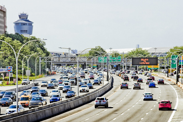
Getting around town, in today’s post.

– photo by Mitch Waxman
A humble narrator’s antipathy towards entering the rat infested bunkers of sweating concrete that underlie the megalopolis has been fully explored in prior posts at this, your Newtown Pentacle. What are you going to do, though? There’s really only one truly economical way to get around in our city, and the subway is it.

– photo by Mitch Waxman
You could drive, I suppose, but one such as myself lives a mere three stops out from the City center, and cannot imagine bearing the costs and pain in the neck that maintaining an automobile would entail. My solution has always been to rent a car when I need one, which is not that often. It’s an expensive caprice, but no where even close to paying annual insurance, gas, and paying for the inevitable parking tickets.

– photo by Mitch Waxman
One has been making a dedicated effort to use the MTA bus system in the last year, as many of the places which I’m headed for in Queens are not served by the Subway system (or if they are, I have to loop through all of Manhattan to get there from Astoria). For instance, getting to Ridgewood, a distance of less than 6 miles from Astoria, would necessitate a 50 minute ride on the M which would visit most of Manhattan and a significant chunk of North Brooklyn.

– photo by Mitch Waxman
Far and away, my favorite form of transit are the ferries, and in particular the giant orange ones. East River Ferry has ironed out a lot of the kinks in their service in the last year, btw, and there’s now a smart phone app which publishes a schedule and anticipated times of arrival at the various landings. You can also purchase tix via the app. The big orange boat is free, incidentally, and is amongst other things – the most popular tourist destination in NYC.

– photo by Mitch Waxman
One would enjoy using the rich man’s preferred mode of transit, if only as a diversion, but this mode of transportation is ridiculously expensive – something like $2,000 per hour.
The best way to see NYC is on foot, of course.
This Sunday, I’ll be leading a walking tour of the eastern side of Newtown Creek for Newtown Creek Alliance, btw. Tix are still available, see the links below for more info.
“follow” me on Twitter- @newtownpentacle
Upcoming Tours –
August 2nd, 2015
The Insalubrious Valley of the Newtown Creek – Bushwick & Mapeth Walking Tour
with Newtown Creek Alliance, click here for details and tickets.
August 8th, 2015
13 Steps Around Dutch Kills – LIC Walking Tour
with Atlas Obscura, click here for details and tickets
no worse
The world is not as it should be, rather it is as it is and always has been.

– photo by Mitch Waxman
When a humble narrator was a boy, there were quite a few “doomsday scenarios” in play. Existential threats included the probable outbreak of a global thermonuclear war fought between the United States and the Soviet Union and the so called “population bomb” which was meant to cause mass starvation (predictions included the deaths of over 60 million Americans due to food shortages – a third of the population at the time). There was also an ozone hole which was meant to BBQ farm and city alike, an atmospheric phenomena whose formation was blamed on the presence of certain chemicals in aerosol hair spray cans. Additionally, an ice age was thought to be just around the corner, one which would depopulate the northern hemisphere and force humanity to cluster about Earth’s equator.
Slightly lower on the scale – but still terrifying – were threats posed by the rise of violent crime, disestablishmentarianism, and the rise of narcoterrorism. The world was ending, so say your prayers.

– photo by Mitch Waxman
There’s a whole set of existential worries afoot these days – sea level rise, global warming, the rise of religion based terrorism, etc. Since these terrors are routinely explored in mainstream media, there’s no reason to repeat them as I’m sure you’re quite familiar with the various story lines. There’s a lot of drums that get beat upon by the “usual suspects.”
For those on the so called “left” – any factory or mill is by definition “satanic.”
For those on the so called “right” – the natural world is merely a collection of unharnessed natural resources.
The lefties want to see strict regulatory controls enacted on business, capital, and seek to curtail personal liberties in the name of protecting populations whom they have decided are vulnerable. The righties wish for an unfettered business environment, cessation of tax and regulation, and to curtail personal liberties in the name of protecting themselves. Both poles see society as teetering on the brink of destruction. Some predict a second American Civil War as being just around the corner.
Both sides populated by absolutists, who are dwellers in ivory towers. One set of towers is found in academia, the others on Wall Street. Both forget about the rest of us.

– photo by Mitch Waxman
There are no Mongol armies about to ride over the hill and force our village to submit to their yoke. If there were, these Mongols would meet the United States Marines, or the Russian Spetsnaz, or the British SAS and there would soon be no more Mongols. It’s no secret that the biggest problem encountered by the United States military in its recent wars was how to fight a war in which you don’t exterminate the entire population of any given country and instead just target the bad guys.
Superman would have to consciously pull his punches when apprehending bank robbers. One good punch from the big guy could reduce a human’s head to a spray of red mist, and his gaze could easily immolate. Criminals in Metropolis would seldom need to be reminded of what they’re dealing with. Neither would the ones in Gotham City.
The lefties would want Superman or Batman jailed for vigilante activity, and the righties would want them to go overseas and slaughter some Mongols.

– photo by Mitch Waxman
Personally, I find both arguments pedantic. There are so many things commonly agreed upon, that are actionable, which get lost in this ideological tug of war that it actually depresses me. Don’t throw litter and garbage into the street? Be nice to each other and don’t call people ugly names? Don’t feign political naïveté? Don’t call yourself a “progressive” when you don’t understand what that means?
Maybe I’m just getting old.

– photo by Mitch Waxman
Maybe everybody else is right, and the Mongols are in fact coming to get us – or we should celebrate their vibrant diversity. The division between the two points of view is exactly the sort of thing which wily old Chingis Khan would have expolited. The Khans viewed themselves as appointed by God itself to rule mankind, and Chingis often referred to himself as “God’s curse.” The Mongol term for submission and peace used the same word.
The Khans would send a rider to the village gates before an attack, who would pronounce the following (the actual quotation is lifted from a letter sent to Pope Innocent IV, in 1246, by Chingis Khan’s grandson Güyük):
“You must say with a sincere heart: “We will be your subjects; we will give you our strength”. You must in person come with your kings, all together, without exception, to render us service and pay us homage. Only then will we acknowledge your submission. And if you do not follow the order of God, and go against our orders, we will know you as our enemy.”
“follow” me on Twitter- @newtownpentacle
Upcoming Tours –
August 2nd, 2015
The Insalubrious Valley of the Newtown Creek – Bushwick & Mapeth Walking Tour
with Newtown Creek Alliance, click here for details and tickets.
August 8th, 2015
13 Steps Around Dutch Kills – LIC Walking Tour
with Atlas Obscura, click here for details and tickets
irresistably borne
Spock was wrong, for the needs of the few outweigh the needs of the many.

– photo by Mitch Waxman
Allow a humble narrator to make this predicate statement, before the condemnations begin: I think Bike Lanes are both necessary and a good thing. I have no fundamental nor ideological objection to dedicated vehicle lanes reserved for human powered transportation. Friends of mine actually sit on the board of Transportation Alternatives, and although I’m not a bicycle commuter (dedicated pedestrian, me), it’s a worthy pursuit to encourage folks to get around under their own steam rather than use a motor vehicle. Saying that, there’s a lot of people who cannot get around under their own steam because… y’know, not everybody is 25 and in perfect health.
A set of bike lanes has recently appeared on the Greenpoint Avenue Bridge, which spans the currently undefended border of Brooklyn and Queens and the lugubrious waters of the fabled Newtown Creek.

– photo by Mitch Waxman
When these bike lanes opened, websites like Gothamist, Curbed, and the rest of the Brooklyn Gold Coast elites applauded the addition. The bike lanes were a personal project for some of the elected officials who I am honored to consider friends on both sides of the Creek as well. These are what is known as “protected bike lanes,” meaning that they have these little plastic bollards running along them.

– photo by Mitch Waxman
Problem here is that mid span on the bridge, which is a primary crossing between the two boroughs, the two motor vehicle lanes that cross the span on both sides now merge into a single lane. The day these shots were captured, I observed three near misses as automobiles were trying to pass heavy trucks (manufacturing zoning on both sides).
The other problem is that while there are a fair number of people who bike over this bridge on a daily basis, their numbers are eclipsed by the cyclopean numbers of trucks and cars that do so as well.

– photo by Mitch Waxman
Several instances of southbound traffic straying into the northbound lanes were observed, and vice versa, and more than one of the heavy trucks had to jam on their air brakes to stop in time to avoid a collision. The problem, as observed, is that there are protected bike lanes for both directions of travel instead of a single dedicated path for bicycle traffic, which necessitates the 4 automotive lanes becoming two at mid span.

– photo by Mitch Waxman
Pictured above, you’ll notice the white auto is forcing the dump truck onto the median “no go” area as traffic merges near the center of the span.

– photo by Mitch Waxman
On the Queens side, the north bound bike lane terminates at a cross walk and then disappears. Just to the east of the bridge’s bike lane is an access road used by the trucks that are exiting from the recycling and waste haulage companies found along Railroad Avenue.
This is a high volume sort of intersection, btw, where Review and Greenpoint Avenues intersect with Van Dam Street and traffic is literally coming at you from six different directions.

– photo by Mitch Waxman
Looking up Van Dam in the general direction of Queens Plaza, the bike lane is intersected by a turn lane for trucks and other vehicular traffic. The Fed Ex truck is in that turn lane and making the left onto Review Avenue, no doubt heading for the enormous Fed Ex facility on Borden Avenue under the Long Island Expressway.

– photo by Mitch Waxman
Here’s a shot of the intersection which is clear of traffic, where the confusing and rather byzantine striping of the traffic indicators is fully revealed. This looks pretty dangerous to me. Notice that the turn lane used by the Fed Ex truck in the previous spot goes right through the bike lane which feeds the south bound lane of the Greenpoint Avenue Bridge.

– photo by Mitch Waxman
Funny thing is, despite all the work and expense of installing these bike lanes, and the series of vehicular hazards introduced to automotive and truck traffic by that center span merge – the bicyclists still seem to prefer using the pedestrian sidewalks – just as they’ve always done.
So, now is the time for the bike people to start attacking me for pointing out that these bike lanes are imperfect and dangerous. Recriminations will include accusations of Fox News style distortion, fealty to a regressive authoritarian system dominated by motor vehicles, and the other usual character assassinations favored by the scholastic and socratic elites who occupy air conditioned offices in lower Manhattan and Downtown Brooklyn.
Hold your sophistry, the Greenpoint Avenue Bridge needs bike lanes, but these ain’t good. We need to do better. I’m talking to you, NYC DOT.
“follow” me on Twitter- @newtownpentacle
Upcoming Tours –
August 2nd, 2015
The Insalubrious Valley of the Newtown Creek – Bushwick & Mapeth Walking Tour
with Newtown Creek Alliance, click here for details and tickets.
August 8th, 2015
13 Steps Around Dutch Kills – LIC Walking Tour
with Atlas Obscura, click here for details and tickets
without warning
A fairly novel spot found in north western Queens, in today’s post.
– photo by Mitch Waxman
As mentioned last week, one enacted a “bat out of hell” protocol when Our Lady of the Pentacle allowed me a brief furlough from a kitchen renovation project here at HQ. My perambulation was committed in an easterly direction along Northern Blvd., which ceases to be pedestrian friendly at 114th street. A northerly turn found me at the intersection of Astoria Blvd. and Ditmars, and since it was a warm afternoon, tree lined Ditmars was the route I elected to take back towards the rolling hills of almond eyed Astoria.
When you say “North Western Queens,” one thinks of jails and airports and power plants and stadiums, and as pictured above – the barrier parkway known as the Grand Central.
There is, however, something else found hereabouts.

– photo by Mitch Waxman
Along Ditmars Blvd., this inviting pedestrian path beckons. Signage found at its intersection informs that this is NYC Parks Department property, and a part of the Flushing Meadows Corona complex.

– photo by Mitch Waxman
The Worlds Fair Marina is noticed first, a boat basin servicing a fleet of privately owned pleasure craft.

– photo by Mitch Waxman
Then, looking to the west and LaGuardia Airport, you observe a part of the Flushing Bay Promenade. Asking around at my local bar, none of the native Astorian lifers even knew this park existed.
Perhaps it’s better known in East Elmhurst, which is the community that hosts it, but my Astoria peeps professed complete ignorance on the subject.

– photo by Mitch Waxman
To the east, something that every Queensican is intimately aware of will be found, the home of our lamentable Mets baseball team at Citifield. Just beyond the stadium are the main sections of Flushing Meadows Corona Park.

– photo by Mitch Waxman
To the west is LaGuardia Airport, and this spot along Flushing Bay was a great location from which to observe the goings on thereabouts.
The NYC Parks Dept. makes this page available at their website, describing the history and rather recent creation of the Flushing Bay Promenade, which is connected to the presence of a large NYC DEP “Combined Sewer Outfall” gray infrastructure project nearby.

– photo by Mitch Waxman
At the western edge of the park was a somewhat natural shoreline, and lots of birds were observed flitting about. Luckily it was high tide when I was visiting, as anyone who has driven along the Grand Central Parkway can describe the sickening rotten egg smell which out gasses from the mud flats here at low tide.

– photo by Mitch Waxman
A smallish homeless camp was observed right along the walls of LaGuardia Airport, and there were makeshift shanties and fabric tents arrayed amongst the tree line. I didn’t venture into the area any further than as indicated in the shot above, however, as I avoid taking shots of residences no matter what their status is.

– photo by Mitch Waxman
The high speed road known as the Grand Central Parkway, pictured above as seen from within the Flushing Bay Promenade, was constructed in the 1930’s. Part of the Triborough Bridge build out, the Grand Central was widened in the post WW2 period to its current dimensions. Another project from the House of Moses.
Robert Moses was a very clever man who mastered the bureacracy of State, City, and Federal highway systems – earning himself the appellations of both “Master Builder” and “Power Broker.” Moses held near absolute power over highway and bridge building, as well as public housing and parks, for nearly forty years before Governor Nelson Rockefeller ousted him from government in 1974.
The NYC we all know is the City that Moses built.

– photo by Mitch Waxman
As with all things government, specificity is key to understanding a thing. The reason that it’s the Grand Central “Parkway,” instead of highway or expressway, are the grassy and wooded medians that run alongside it. Since these medians are titular “parklands,” Moses had broader powers of eminent domain when claiming and remodeling the area to drive a high speed road through it.
Moses also built LaGuardia Airport, incidentally.
“follow” me on Twitter- @newtownpentacle
Upcoming Tours –
August 2nd, 2015
The Insalubrious Valley of the Newtown Creek – Bushwick & Mapeth Walking Tour
with Newtown Creek Alliance, click here for details and tickets.
August 8th, 2015
13 Steps Around Dutch Kills – LIC Walking Tour
with Atlas Obscura, click here for details and tickets
last stages
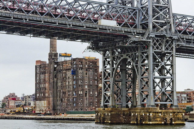
The modern day East River in today’s post, which bums me out.

– photo by Mitch Waxman
One such as myself once absolutely loved the idea of riding the East River Ferry. As a matter of fact, I seem to enjoy all ferry rides, presuming that the deck is accessible and amenable to photographic pursuits. These days, the actual experience of doing so brings on depressive episodes. One of the problems with the “historian” point of view is that you tend to realize that whatever rises must also fall, and that bills must ultimately be paid. That is why we all toil and labor, to service debts, and the City of New York is currently racking up a hell of a tab.
Recently, the Alice Oldendorf bulk cargo ship was observed at work, making a delivery to a concrete plant at the Brooklyn Navy Yard as I rode the aforementioned ferry.

– photo by Mitch Waxman
The ship hosts a series of cranes and conveyors which unload her holds, producing the cyclopean mounds of sand and gravel witnessed above. It’s nice to know that at least some part of ancient Williamsburg still hosts a working waterfront, or at least a working waterfront that is engaged in the production of something other than artisanal pickles.
– photo by Mitch Waxman
One cannot help but drop his jaw whenever the former Havemeyer or Domino Sugar plant site comes into view. It is being redeveloped as a residential structure – more luxury condos for the children of the rich to dwell within. The question of what will happen to these structures when NYC slides backwards into an era of degeneracy and decay is one few ask.
Any historian will tell you that it’s a cyclical thing here in the megalopolis, one that flips back and forth on a roughly forty year cycle which can be directly correlated to rates of crime, and that the City’s current upswing began in the late 1990’s – reversing a decline process that started shortly after the Second World War.
Rich people tend to move away from the City center when things get hairy. The rest of us are kind of stuck here.

– photo by Mitch Waxman
Williamsburg is officially lost as a point of interest for me. Bland boxes of steel and glass will extend all along the East River soon enough, stretching from the former industrial heartland once called “America’s Workshop” in Long Island City all the way through the Gold Coast of North Brooklyn to the Williamsburg Bridge. Criminals are already beginning to focus their attentions on this area, just as they did in the age of industry. Why? Because predators go where the prey is.
It’s cliché to even comment on it anymore, one realizes.

– photo by Mitch Waxman
Scenes long familiar, lost. The wilderness of the oligarchs is upon us, and deep in the woods – wolves howl to celebrate and delight. The nobles will be safe in their keeps, but the peasants – we’re on our own.
“follow” me on Twitter- @newtownpentacle
Upcoming Tours –
August 2nd, 2015
The Insalubrious Valley of the Newtown Creek – Bushwick & Mapeth Walking Tour
with Newtown Creek Alliance, click here for details and tickets.
August 8th, 2015
13 Steps Around Dutch Kills – LIC Walking Tour
with Atlas Obscura, click here for details and tickets.
As detailed in this recent post, my camera was destroyed in an accident.
For those of you who have offered donations to pay for its replacement, the “Donate” button below will take you to paypal. Any contributions to the camera fund will be greatly appreciated, and rewarded when money isn’t quite as tight as it is at the moment.


