Archive for October 2021
terrestrial gravity
Friday

– photo by Mitch Waxman
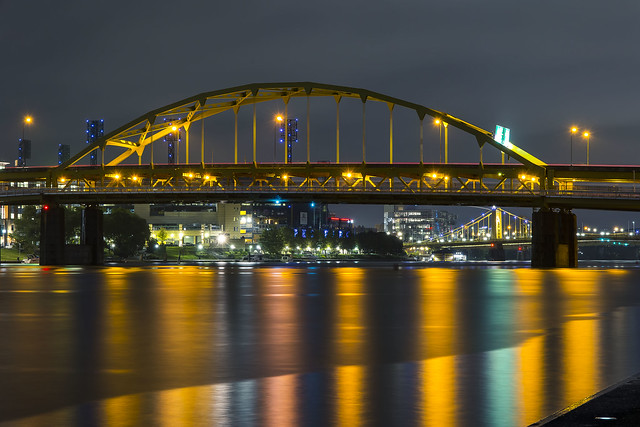
Day two in Pittsburgh began before the sun came up, and I was showered/dressed/ and charging the camera batteries up for another bridges heavy shot list. The day’s weather forecast was perfect for me – middle 60’s, breezy, and a bit overcast but no rain.
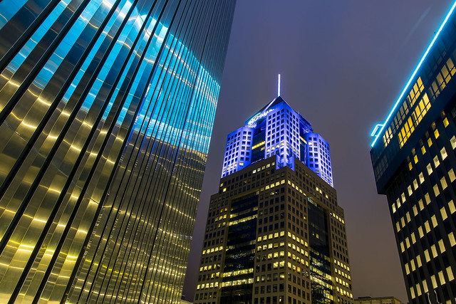
At the center of that shot above is the tallest building in Pittsburgh. It’s the 58th tallest building in the United States, and used to be known as the USX tower. Today, it’s the called the U.S. Steel building, and it’s the HQ for that company as well as UPMC – the University of Pittsburgh Medical Center – whose illuminated logo adorns the summit.

– photo by Mitch Waxman
Funnily enough, the shot above was total serendipity. I was throwing out a bit of garbage I had generated over the last two nights in the AirBNB at the Clark Building, and this is the view from the garbage room, which looks towards the Alcoa building on the Allegheny River’s north shore and the 10th and 9th street (Andy Warhol and Rachel Carson) bridges. I walked out onto Liberty Avenue at about 7 in the morning.
First thing on my list was breakfast, and since throughout these travels the heavy pancake/bacon/egg deal had served me well, I was looking for a diner or coffee shop to purchase a meal of that type. A bit of quick googling revealed a spot just a few blocks away, but it didn’t open until 8 a.m. so I had a little time to kill. After a cup of steaming black coffee was obtained at a convenience store, I was on my way.

– photo by Mitch Waxman
Pittsburgh seems to have a lot of alleys. They also haven’t turned all of their downtown parking lots into condominiums with the proviso that you should ride a bike or you’re an asshole, or intone that you hate minorities if you oppose more luxury housing, the way they do in NYC. It’s almost like Pittsburgh has other industries whose opinion matters, beyond the one offered by big real estate, when the Electeds are making decisions here.
Naturally attracted to shunned places, I had to walk through a few of them. I spotted this hilarious sign in one of those alleys.

– photo by Mitch Waxman
While “photowalking” to breakfast, I spotted lots of intriguing and fairly old municipal buildings like the Firehouse pictured above. I also observed that the infamous Midwestern “Opioid Epidemic” has taken over a lot of lives hereabouts. Drug and addiction treatment centers abounded, and I saw hundreds of people waiting on line for their little plastic cups of orange liquid (methadone) who all wore the tell tale mask of heroin use on their faces. That sucks. I don’t wish that life on anyone, even if they did it to themselves. Heroin breaks people into little evil pieces, and turns them into shadows. You can call it OxyContin if you like, but it’s heroin. This drug epidemic is the actual consequence of going to war in Afghanistan, by the way.
Poor bastards.

– photo by Mitch Waxman
An old downtown department store was receiving a lot of attention from construction crews when I passed by, and luckily this amazing public timepiece wasn’t being demolished by them. Just look at that thing. Jeez. Talk about gilded age, huh.
Most of the historic building stock encountered was reminiscent of the early 20th century examples you encounter in Manhattan’s financial district. Ornate Neo classical facades, street level grand entrances, lots of massive stone structure punctuated with enormous plate glass windows. Cathedrals of Capitalism. Unlike NYC, setbacks for upper floors didn’t seem to be a thing here, and you have all of these dark and shadowed alleys between and behind which expose the “works” of the buildings – the HVAC piping, electrical hookups, and so on.

– photo by Mitch Waxman
After breakfast, I summoned a LYFT ride share to carry me to my first destination of the day on the south side of Pittsburgh on Mount Washington. Formerly called Coal Hill, the prominence was dubbed Mt. Washington in 1876. It hosts the two inclines – or Funicular Railways – and is on the south side of the Monongahela River. Mt. Washington offers an elevated point of view from which any visiting photographer is obliged to actuate the shutter. Ultimately, most of my second day in Pittsburgh was spent in close association with Mt. Washington and the Monongahela River. The boat tour I had purchased advance tickets for would leave its dock from this side of the city later in the day.
More next week – at this – your Newtown Pentacle.
“follow” me on Twitter- @newtownpentacle
Buy a book!
“In the Shadows at Newtown Creek,” an 88 page softcover 8.5×11 magazine format photo book by Mitch Waxman, is now on sale at blurb.com for $30.
certain circumstances
Thursday

– photo by Mitch Waxman
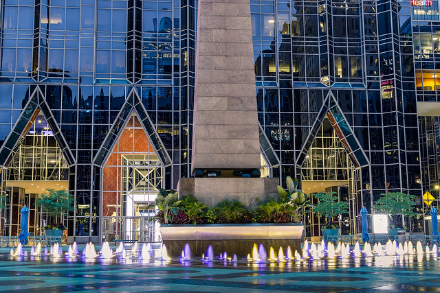
After eating dinner at one of Pittsburgh’s iconic Primanti Brothers restaurants, one got busy on his evening plans. The camera was rigged up for low light/night shooting, and a humble narrator got to work. Pictured above and below are sections of PPG Place, a 1984 vintage six building commercial real estate complex built and primarily occupied by the Pittsburgh Plate Glass outfit. The main 40 story building, whose ground floor entrances sit behind that fountain, is the corporate headquarter for PPG. The entire deal is clothed in plate glass, some 19,750 panels (over one million square feet of glass) of it, which is why it looks like an early 1990’s CGI background. Wet glass, LED lighting, weird look and feel. PPG has operated out of Pittsburgh since 1895.
The PPG complex sits on six square blocks or one square acre, replaced a department store called Guskey’s, and it’s construction revealed a cornucopia of archaeological finds ranging from Native American to early Colonial and pre industrial uses of the site. The main tower is the third tallest building in Pittsburgh.
– photo by Mitch Waxman
As mentioned several times in the last few weeks, on this particular interval of travel, one felt compelled to record the scene whenever and wherever a fountain was discovered. This wasn’t much of a fountain, in comparison to what I saw in Washington D.C., but there you are. Apparently, during the holiday season and winter months, this plaza is converted over to be an ice skating rink. It’s a fave for Pittsburghers, apparently, with high occupancy rates and several newspaper polls listing it as the voted on choice for “best building” in the City.
– photo by Mitch Waxman
The fourth tallest building in the City of Pittsburgh is nearby, which is called “Fifth Avenue Place” officially, but is colloquially called Highmark Place. 31 floors, and completed in 1988, it’s the HQ for a Highmark subsidiary called Jenkins Empire Associates. Highmark is a non profit health insurance organization which also owns several for profit medical insurance and reinsurance companies. Basically – Highmark is the corporate entity that Pennsylvania and West Virginia’s Blue Cross and Blue Shield have reorganized themselves into.
The building was originally meant to be a bit taller, but city zoning officials squashed that. The 13 story tall spire atop the building was an attempt to lay claim to the original height that the architect planned for, and with all the hub bub over the zoning deal it was never transmitted to the City that the spire/mast was designed to sway up to three feet when high winds hit the top. It seems that the first time this sway was observed, Pittsburgh’s First Responders shut the downtown area down fearing that something catastrophic was about to occur.
– photo by Mitch Waxman
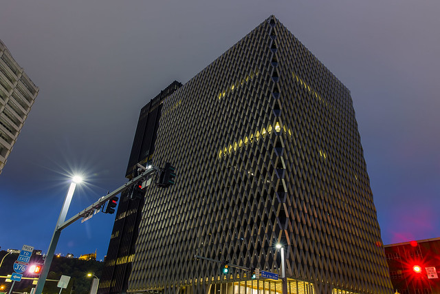
Developed by the Equitable Life Assurance Society, in 1964, this “caught my eye” structure – with its fascinating load bearing external diagrid and framed tube steel exoskeleton – was built on the footprint of an old Wabash Terminal Train Shed. When it opened as the IBM Building, its principal tenants were the IBM corporation on floors 1-4 and U.S. Steel on floors 5-13. It was bought by the United Steelworkers Union in 1973, and the labor organization’s offices are still housed therein.
A bit of skyscraper trivia is offered here. The same people who designed the external structure of the building also did the World Trade Center in NYC. Just like the WTC, the structure of the building is outside the walls, and within the only structural supports are at the center of the thing surrounding the elevator and plumbing/electrical cores. Neat!
– photo by Mitch Waxman
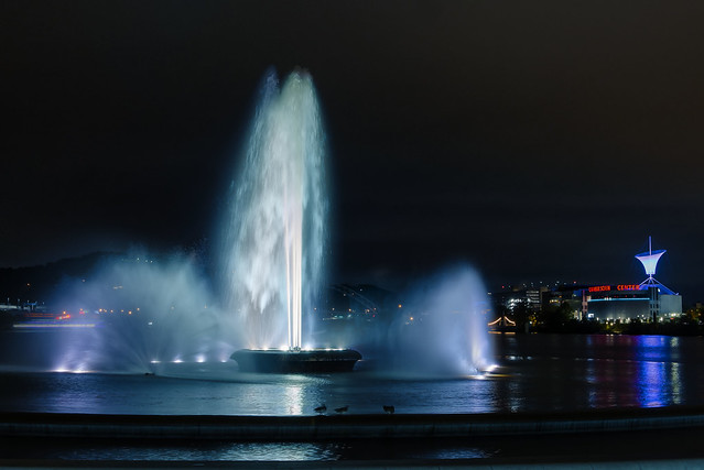
My next stop was yet another fountain, this time being Pittsburgh’s “big kahuna” at Point State Park. It’s found at the “tip of the spear” on the river delta formed by the three rivers – Ohio, Allegheny, Monongahela. 36 acres in size, this Pennsylvania State Park was opened in 1974. Its fountain is the iconic center of the larger metropolitan region, and Pittsburgh’s reclamation of its post industrial waterfront really started with the opening of this park. The fountain sits where the on and off ramp of two bridges used to be found, the Manchester and Point Bridges.
The park incorporates the remains of Fort Pitt and Fort Duquesne, which were important fortresses during the French and Indian War (1755-1764) and although I’m largely ignorant about the details of the conflict here at the ‘forks of the Ohio,” there’s a nearby spot referred to as “Washington’s landing” so… George Washington.
– photo by Mitch Waxman
The one Allegheny River Bridge between Point Park and the 31st street Bridge I didn’t show you yet is pictured above, the so called “Bridge to Nowhere” or Fort Duquesne Bridge. It carries Interstate 279 (North Shore Expressway) and Interstate 376 into and out of Downtown Pittsburgh and also has a pedestrian walkway in the lower deck. It’s got a steel bowstring type span of 426 feet, and provides a water clearance of 46 feet. It opened to traffic in October of 1969.
Whew. All of this Pittsburgh stuff that you’ve seen here at Newtown Pentacle for the last two weeks was literally captured in one day between 7 a.m. and about midnight. It started raining again while I was capturing the bridge shot above, so I double timed it back to the street and caught a cab back to the AirBNB. Starting tomorrow – Day two. I was just getting started on day one, and had to contend with the weather, and I also had tickets for a boat tour of the rivers nested in my pocket for day two. The things I saw…
If you haven’t yet subscribed to Newtown Pentacle, please consider doing so using the “sign me up” button and field at the top right.
Also, I’d greatly appreciate it if any of you could share these posts out to your social media accounts if you like them. I’m about to start doing tours of Newtown Creek again, I think, and would like to increase the “reach” and readership of this continuing effort.
“follow” me on Twitter- @newtownpentacle
Buy a book!
“In the Shadows at Newtown Creek,” an 88 page softcover 8.5×11 magazine format photo book by Mitch Waxman, is now on sale at blurb.com for $30.
other constellations
Wednesday

– photo by Mitch Waxman
As mentioned in prior posts, a humble narrator took his camera on vacation in September. The camera wasn’t bored, but it’s been trapped here in NYC since arriving from Japan at the end of 2020 due to COVID restrictions and all that, so I wanted to show it what other parts of the USA look like. Amtrak takes you places, and one of the places we went together was the pretty city of Pittsburgh.
One left the rented room in Pittsburgh early in the morning, after having received weather forecast warnings about a powerful line of storms meant to arrive in the area where their three rivers converge about 4:30 p.m. Accordingly, one’s activities for the day had been built around this. After exploring both sides of the Allegheny River frontages, a humble narrator began scuttling back towards the AirBNB I was staying at in downtown Pittsburgh.

– photo by Mitch Waxman
That’s the PPG tower. Pittsburgh Plate Glass, that is, and if there’s an “Empire State Building” in this city, I guess that’s the one. Proper photographs of the thing will be offered tomorrow, the shot above is a bit more of a “snapshot” than it is a photograph.
On the way back to my room, I picked up some coffee and a couple of bananas at a 711. Also as mentioned, the temperature when I left in the morning was about 60 and over the course of the day it had risen to about 85 and it was quite humid. One had been out wandering and walking all day and I was perspiring.

– photo by Mitch Waxman
The AirBNB was in a former office building which had been converted over to residential usage called “The Clark Building.” Apparently, it used to be the regional HQ for Warner Brothers, was built in 1928, and I was staying on its 23rd floor. The elevation provided a front row seat to the oncoming storm, and after a quick shower and change of clothes, the window was first rolled up and then the tripod was deployed so that the camera could watch the show.
I really was hoping for lightning, but c’est la vie, huh?

– photo by Mitch Waxman
For about 90 minutes, rain and wind pummeled Pittsburgh, and according to the local news I was watching on my phone, a tornado had set up nearby the Allegheny county line that caused no small amount of damage. Me? I was sitting pretty, drinking coffee and enjoying a banana.
I also took this opportunity to offload the day’s photo effort from the onboard memory cards of the camera to the laptop which I had carried with me all the way from Queens in NYC. I recharged the batteries and wiped down the equipment.

– photo by Mitch Waxman
After the front had passed, the temperatures dropped back into the low 60’s, and there was still a bit of occasional drizzly rain coming and going. Around the corner from the Clark Building, an ornate movie theater was observed with a lit up marquis advertising a showing of the “Wizard of Oz.”
When in Rome, as the saying goes, and since I required a meal at this point – as I had long ago digested the pancake breakfast quaffed nearby the Heinz Factory on the north side of the Allegheny – I headed for a nearby outpost of Pittsburgh’s iconic “Primanti Brothers” sandwich shops.

– photo by Mitch Waxman
The Primanti Brothers sandwich is a “cholestival festival.” I ordered the menu item they called “The New Yorker.” How could I not, after all? Pastrami, Corned Beef, french fries embedded in the sandwich… delicious, but it’s a cardiologist’s nightmare made manifest on a plate. I washed it all down with a couple of pints of Yuengling, which is apparently a locally manufactured beer. After eating, I gathered my crap together and decided to remain busy.
Tomorrow – night shooting in Pittsburgh.
“follow” me on Twitter- @newtownpentacle
Buy a book!
“In the Shadows at Newtown Creek,” an 88 page softcover 8.5×11 magazine format photo book by Mitch Waxman, is now on sale at blurb.com for $30.
human clothing
Tuesday

– photo by Mitch Waxman
The Allegheny River in Pittsburgh is adjoined on both banks by the “Three Rivers Heritage Trail” which offers pedestrians and bicyclists a series of stunning views. That’s the 16th street or David McCullough bridge, which is of the “steel trussed through arch” type. It was erected in 1922, replacing the earlier 1838 Mechanics Street Bridge. It’s some 1,900 feet long, on ramp to off ramp, and 40 feet wide. In 2013, it was renamed for historian and native son David McCullough.
As you may notice, I had retooled the camera back into its tripod mode at this point. Mid afternoon sunlight isn’t exactly kind to photographic pursuit, and I had to handle the situation. A ten stop ND filter allowed me to “slow the exposure” down, and all the shots in today’s post were accomplished using this particular technique.

– photo by Mitch Waxman
This shot looks towards the direction of the junction of the three rivers – Ohio, Allegheny, Monongahela – from the pedestrian pathway of the 16th street Bridge. One of the things that I really enjoyed in Pittsburgh was the near complete lack of chain link security fences occluding the views. It’s one of the truly frustrating things about NYC, these fences and occlusions. Actually, almost everything in NYC is annoying and frustrating.
A humble narrator was in a full sweat at this stage of the day as the atmospheric pressure began to build up ahead of that front of storms moving in. I got moving, looking for shade, and started heading towards the “point” of the delta.

– photo by Mitch Waxman
A “steel and welded girder” type truss bridge, the fairly uninspiring Veterans Bridge opened in 1988. It carries the 7 lane interstate 579 into and out of the center city on a north/south axis, and one of those lanes is a reversible high occupancy vehicle lane meant for buses and other transit related usage. On ramp to off ramp, it’s 1,050 feet long, but the section spanning the Allegheny River is 410 feet which sits some 51 feet over the waters.
While shooting this image, I had to contend with a territorial gaggle of Canada Geese, who – as a specie – are dicks. Everywhere I go, gooses abound.

– photo by Mitch Waxman
Next up is the American Bridge Company built “Fort Wayne Railroad Bridge” which continues the deal here in Pittsburgh of bridges having more than one name. According to the National Register of Historic Places, this is alternatively the Pennsylvania Railroad Bridge. It’s also known as “Bridge No. 1, Pittsburgh, Fort Wayne and Chicago Railway.”
It’s of the “double deck steel truss” type, and it’s 5 spans cross some 985 feet. The longest span is some 319 feet long. It’s 40.9 feet over the water, and replaced an 1868 forebear that sat just outside of this one’s footprint. It was opened for rail traffic in 1904, and was raised in 1918 to its current height to increase navigability. This is something that they managed to pull off without interrupting rail traffic.
I actually got pretty lucky with my timing right here.

– photo by Mitch Waxman
The lower deck is inactive, and as you can see in the shot above (and not for the last time during my 72 hours in Pittsburgh), the upper deck carries freight and passenger traffic. Freight rail operator Norfolk Southern’s Fort Wayne Line, and Amtrak, cross the Allegheny on this bridge.
Score! Freight rail in the steel city. Little did I know… but that’s another post for another day.

– photo by Mitch Waxman
The Ninth Street Bridge, aka the Rachel Carson Bridge, is one of three relatively small bridges which all seem to be very similar in design if not identical. Suspension Bridges with eye bar catenary cables, it sits in close association with the Andy Warhol Seventh Street Bridge and the Sixth Street Roberto Clemente Bridge. Unveiled in 1926, Ninth Street Bridge is on ramp to off ramp 995 feet long, and 840 feet of it spanning the Allegheny River is just over 40 feet from the water.
This was my “head back to the room” shot, incidentally, as that approaching line of thunderstorms was now only a half hour away and people’s phones were going off warning of possible tornado formation.
I’m not clear on what water level indicates in Pittsburgh, by the way. I keep on seeing references to an Emsworth Dam and it’s normal pool level as being 710 feet above sea level and that seems to be the effective level of the water locally. Any of you engineer types or Pittsburgh experts who might be reading this and who can elucidate – leave a comment on this post. I live by the sea, on an archipelago. It’s called NYC. I don’t know your mountain ways.
More tomorrow.
“follow” me on Twitter- @newtownpentacle
Buy a book!
“In the Shadows at Newtown Creek,” an 88 page softcover 8.5×11 magazine format photo book by Mitch Waxman, is now on sale at blurb.com for $30.
choked fissure
Monday

– photo by Mitch Waxman
As described in previous posts, a humble narrator used an Amtrak Rail Pass during the month of September to carry the camera to various locales in the North Eastern United States. First up was a short day trip interval in Washington, D.C., followed by a long train ride on Amtrak’s “Capitol” line to Pittsburgh. In last week’s posts, I brought you along with me on the north shore of the Allegheny River all the way to the 31st street Bridge, where I crossed back on to the river delta known as the “Golden” or “Iron” Triangle, and we entered a rapidly developing post industrial area referred to as “the Strip.”
The Strip is my kind of jam, by the way. Surviving industrial buildings repurposed rather than demolished, and when you encounter new construction it acknowledges the neighborhood it’s in rather than trying to destroy/replace/obfuscate it. I’m looking at you, Long Island City, right in the eye.

– photo by Mitch Waxman
I’m trying to not get super granular in these postings about Pittsburgh, given that I was only physically present in the City for 72 hours and of that interval – awake and shooting for about fifty hours. Saying that, the Phoenix Brewing Company building caught my eye. A bit of quick looking revealed that the folks at both “pittsburghbrewers.com” and the “The Urban Redevelopment Authority of Pittsburgh” have paid some attention to this structure well before I wandered past it.
It was pretty warm, weather wise. Again, the weather in Pittsburgh is super dynamic. When I had woken up and left the AirBNB, it had just finished raining and was overcast and in the 60’s. Here I was just a few hours later, and it was sunny and middle 80’s. I had a bit of an atmospheric deadline to oblige, as a line of strong thunderstorms was meant to arrive and rip through the City between 4:30 and 6:00 p.m. My plan was to keep shooting until 4, then head back to the rented room to offload the photos from my camera onto the laptop while sheltering from the weather.

– photo by Mitch Waxman
Pictured above is new construction, residential in nature, as encountered in the post industrial Strip district. Given that this is the “hip” section, and where several of the “new economy” companies like Facebook and Google have thrown down stakes, if this was NYC the real estate people would have to be saved from drowning on their salivations. The powers that be in NYC would be screaming about density and affordable housing and describe critics of their greedy intentions as racist or classist “NIMBY’s” who wanted to deny mostly wealthy people a home. They’d build a Tower of Babel sized glassine spire here, not caring about the effect it had on municipal infrastructure like the number of hospital beds or school desks. It seems they’re following a different plan in Pittsburgh, and trying to keep things fairly human scale.
“Post industrial” is a term I use a lot, and it bears a bit of explanation. A Post Industrial area is a plot of land which once housed a manufacturing or warehousing operation. It’s usually quite polluted, and more often than not the property ended up in the hands of the local municipality due to the original owner – a company, say – leaving the area or going bankrupt. Municipal entities all over the world struggle with what to do with this category of land, which often requires expensive remediation procedures to occur before it’s safe for other uses like housing. There’s a serious difference between what’s considered safe for “occupational exposure” eight hours a day versus “residential exposure” which is twenty four hours a day. More often than not, these post industrial parcels adjoin waterways or railroad tracks. A regional decline in heavy industrial and manufacturing economic activity following the creation of the Interstate Highway system in the late 1950’s had particular impact on the Northeastern United States, as industry fled to the American south and southwest in the 1960’s where land and labor are a lot cheaper. These areas allowed them to diminish the power of Organized Labor in “Right to Work” states, and fairly undeveloped land in the American South in particular allowed them to erect enormous horizontal campuses that complimented the new truck based – or intermodal – form of transporting their goods to market. This process got our of control, from a national economy pov, when corporations continued this process internationally and exported their operations first to Mexico and Central America and then overseas to East Asia.

– photo by Mitch Waxman
What got left behind when the businesses left, however, were the workers, and the buildings. NYC (along with all of the other 19th century NE industrial superpowers like Buffalo, Rochester, Boston, Philadelphia, Pittsburgh) experienced record unemployment and economic devastation along its waterfronts during the 1970’s and 80’s.
Pittsburgh, alternatively, saw it’s population cut in half at the same time that it lost most of its corporate tax base. What do you do as an individual when you lose your job? Belt tightening and you eat peanut butter sandwiches or spaghetti with ketchup sauce until you find a new one, right? The Strip area here in Pittsburgh was largely abandoned. From what I’ve read about Pittsburgh’s recovery over the last 50 or so years, post industrial has meant a lot of grief, debt, and lateral thought.
That’s the St. Stanislaus Kostka Church pictured above, an 1891 Polish Roman Catholic Church, which is listed on the National Register of Historic Places.

– photo by Mitch Waxman
Again, the topology of Pittsburgh kept on surprising me. Check out that change in elevation from where I was standing on Smallman Street nearby a series of repurposed agricultural and rail warehouses, as compared to that large house up on the hill. The riverine valley nature of this area lends itself to high humidity in the flatlands along the rivers, and even if you’ve got the bucks to afford living up on the ridges overlooking the City, you’ve still got humidity issues to deal with, but you’re able to say that “you’re above it all.”
Seriously though, everywhere I went, one of the odd things I observed was that there were always dehumidifier units laboring away. On large buildings, these units had outfall pipes feeding a steady stream of water directly into street drains. I imagine mold must be a serious issue for homeowners here.

– photo by Mitch Waxman
Wandering mendicants can opine about post industrial economic development and land use endlessly, but that isn’t what my mission for the day was. What drew me to Pittsburgh, in fact, was it’s waterfront and in particular its amazing collection of bridges.
Pictured above is the 16th Street Bridge, aka the David McCullough bridge. David McCullough wrote what I consider to be one of the best NYC history books of all time – 1972’s “The Great Bridge,” which detailed the story of the Roeblings, Tammany Hall, and the building of the Brooklyn Bridge. If you want to get a feel for what NYC was like in the middle to late 19th century – get this book. There’s also a fantastic audio book version of it available at audible. David McCullough was a native Pittsburgher.
More tomorrow.
“follow” me on Twitter- @newtownpentacle
Buy a book!
“In the Shadows at Newtown Creek,” an 88 page softcover 8.5×11 magazine format photo book by Mitch Waxman, is now on sale at blurb.com for $30.


