Archive for January 2010
A Great Machine

Queensboro Bridge and associated structures- “The Great Machine” – photo by Mitch Waxman
Queensboro, whose steel has cantilevered the flow of traffic to the shining city from the fabled vastness of the Long Island since 1909, is merely the focal point of a polyglot mechanism whose works spread into the east. The backbone of New York City runs through the marshy hillocks of western Queens.
As I’ve said in the past:
Airports, railroad yards, maritime facilities, petrochemical storage and processing, illegal and legal dumping, sewer plants, waste and recycling facilities, cemeteries. The borders of the Newtown Pentacle’s left ventricle are festooned with heavy industry and the toll taken on the health of both land and population is manifest. A vast national agglutination of technologies and a sprawl of transportation arteries stretching across the continent are all centered on Manhattan- which is powered, fed, and flushed by that which may be found around a shimmering ribbon of abnormality called the Newtown Creek.
Light rail (subway) and vehicle traffic focus toward Queens Plaza, and within a three mile radius of this place can be found- the East River subway tunnels, the Midtown Tunnel, multiple ferry docks, and the titan Sunnyside Rail Yard which connects to the Hells Gate Rail Bridge. This “Great Machine” is the motive engine that allows millions to enter and leave Manhattan on a daily and reliable schedule from North Brooklyn, Queens, Suffolk and Nassau Counties. The great endeavor called “The East Side Access Project” and its associated tunneling is also occurring nearby, which will terminate at a planned LIRR station sited for the corner of Queens Blvd. and Skillman Avenue.
from wikipedia:
The Queensboro Bridge, also known as the 59th Street Bridge, is a cantilever bridge over the East River in New York City that was completed in 1909. It connects the neighborhood of Long Island City in the borough of Queens with Manhattan, passing over Roosevelt Island. It carries New York State Route 25 and once carried NY 24 and NY 25A as well.
The Queensboro Bridge is the westernmost of the four East River spans that carry a route number: NY 25 terminates at the west (Manhattan) side of the bridge. It is commonly called the “59th Street Bridge” because its Manhattan end is located between 59th Street and 60th Streets.
The Queensboro Bridge is flanked directly on its northern side by the freestanding Roosevelt Island Tramway.

Queens Blvd. at Skillman Avenue – photo by Mitch Waxman

Queens Plaza multi level elevated train station – photo by Mitch Waxman
When Queensboro was built, it became the fastest way into town and horse drawn wagons still carried manufactured goods from the mill workshops of Long Island City and agricultural products from points East (hauled into LIC by the LIRR) into Manhattan. The subways tracks were attached to the superstructure of the bridge. Trucks replaced the horse wagons, and eventually made the cargo hauling operation unprofitable for the LIRR’s gantry docks at Hunters Point. The automobile route and light rail options also collapsed the old passenger and cargo ferry industry which sailed from LIC and Astoria (especially Hallets Point). As the population of Queens left its cradle in LIC and along the East River shoreline, moving ever eastward toward the open country of Long Island, the narrow streets of ancient Newtown were given over more and more to industry. The Great Machine reached further toward the dawn, straining to carry the ever increasing load.
note and minutiae: sartorial mention by learned experts has informed me that the myriad colors that the steel in Queens Plaza is painted reflects the particular line or system that it was erected to serve.

Queens plaza complex – photo by Mitch Waxman

Queens Blvd. at 32 pl. – photo by Mitch Waxman
Following the machine past Skillman Avenue, as it carefully skirts the titan Sunnyside Railroad Yards and the cyclopean Degnon Terminal, one finds the auspicious origin of Queens Boulevard. A primary local artery with an elevated subway track directly connected to the Queens Plaza complex, Queens Blvd. is a central viaduct of population movement away from Manhattan toward points east. Sunnyside, Flushing, Roosevelt, Corona exist in their modern incarnation because of this structure- which like many parts of New York City- must be considered from those hidden structures beneath the street in addition to the visible sections.
There are thousands of mechanisms down there, cables and pipes and electrical transformers, steel underpinnings of the road itself. Realize the complexity of designing a street that can carry fully loaded modern trucking without collapse or subsidence, absorb the vibration and crushing weight of active subway tracks, and also carry a subterranean network of sewer and wastewater systems that can handle the storm runoff from so many acres of concrete. Of course, this complexity was designed over generations of dedicated improvements, but it boggles the mind to… think about what it is… that may be… buried down there.
for a thorough history of the neighborhoods which lie along this section of Queens Blvd., complete with historic photography- check out the work of the masters at Forgotten-NY

End of Naked Steel, Queens Blvd. – photo by Mitch Waxman
After diverging from the Queens Plaza complex, the steel is soon observed as clad in artistic cement, and its pleasing appearance mirrors a Roman viaduct. Such architectural analogy, referencing the time before Caesar did away with pretense, was an artifice used extensively in the era of Progress. Look at the majesty of Washington DC, the Tweed courthouse in Manhattan, or Speer’s plans for the New Berlin during the reign of the last antichrist.
from wikipedia:
Queens Boulevard was built in the early 20th century to connect the new Queensboro Bridge to central Queens, thereby offering an easy outlet from Manhattan. It was created by linking and expanding already-existing streets, such as Thomson Avenue and Hoffman Boulevard, stubs of which still exist. It was widened along with the digging of the IND Queens Boulevard Line subway tunnels in the 1920s and 1930s, and in 1941, the city proposed converting it into a freeway, as was done with the Van Wyck Expressway, but with the onset of World War II, the plan was never completed.

Queens Blvd. looking west – photo by Mitch Waxman
This line of rail continues eastward, sending offshoots into extant neighborhoods. Enormous numbers transverse this street, so much so that it generates statistical norms that stand in contrast to surrounding streets only a block or two away. There is a high rate of just about every affliction or situational outcome possible along Queens Blvd., probability is altered by sheer force of numbers. Spikes in auto accidents or criminal activity far out of scale with surrounding neighborhoods has garnered the infamous “Boulevard of Death” nomen and results in scaled up traffic and transit police patrols all along the route. It’s a bit of a misnomer, as the “just passing through” population of any 1 block stretch on Queens Blvd. is easily the size of a small town. Subways, manhattan bound traffic, pedestrians, residents, shoppers, workers- fuhgeddabowdit.
from wikipedia:
This street hosts one of the highest numbers of New York City Subway services in the city. At any one time, six services—the E, F, G, R, V, and the 7—all use significant stretches of the right of way; only Broadway (nine services), Sixth Avenue (seven), and Seventh Avenue (seven) in Manhattan and Fulton Street (eight) and Flatbush Avenue (six) in Brooklyn carry more at any one time. In addition, the Q60 bus travels its entire length.

End of the line out in Corona – photo by Mitch Waxman

39th (Beebe) avenue elevated station – photo by Mitch Waxman
Another branch of the Great Machine slinks out of Queens Plaza along Northern Blvd. and turns at 31st street, carrying the N and soon to be defunct W lines. This structure continues into and provides the only rail link for the extant sections of Astoria found beyond the noble stature of Ditmars Blvd. This stop is the first on the line, serving Dutch Kills, and its nascent hospitality industry. Before long, this stop will be a primary port of embarkation for hordes of tourists returning from Manhattan. What will greet them, currently, is a coffee shop/greasy spoon and a series of auto garages. Most of the private homes along this block have shuttered windows and zero tenancy, undoubtedly being stockpiled for future large scale development.
from wikipedia:
The Astoria Line was originally part of the IRT, as a spur off the IRT Queensboro Line, now part of the IRT Flushing Line (which didn’t open to the north until April 21, 1917). The whole Astoria Line north of Queensboro Plaza opened on February 1, 1917, and was used by trains between 42nd Street–Grand Central and Astoria.

N Train on elevated BMT tracks – photo by Mitch Waxman

– photo by Mitch Waxman
This is one of those hotels, a Holiday Inn which was recently completed on 39th Avenue and 29th street. Eccentric in design, it is one of the larger buildings visible in western Queens, but is already being dwarfed by newer construction nearby. Greatest of all, the thing in the Megalith watches from on high, as Queens rises.
The European travel industry is a highly evolved entity, which sells “package holidays” combining lodging and travel into one flat rate. Profit is found by booking airline seats and hotel rooms in bulk, garnering discounts from suppliers, and reselling at a higher price to consumers. Its all very civilized, and results in a very competitive pricing strategy which offers real value. Imagine, a trip to New York, all-inclusive for a flat rate- and staying at a brand new hotel two stops from the Apple Store and Central Park!
Really, I’m not being sarcastic. If you’re going to Europe, buy a ticket for London and then put your trip together there. You’ll end up flying to Italy or Bruges on some crap airline, where the in flight entertainment is a non stop commercial selling duty free booze and you’re surrounded by the recently drunk, but who cares… you’ll save a bundle as compared to the ala carte system. The hotel will be downright crappy too, but you’re only sleeping there- you’re in Europe- go to a museum or something. That’s pretty much how most international tourists think about Hotels, that’s the market- hopefully the Hotel investments at Dutch kills can grab a piece of it. Really, I’m not being sarcastic, Queens needs those jobs, and this conversion is fairly inevitable.
I wish that nothing would ever change, and I’ll miss the quirky edges and small stature of this enigmatic little neighborhood, but nothing is going to stop this transformation. I just hope that artifacts of what once was, like the LIC millstones, can be preserved and experienced by the public.

– photo by Mitch Waxman
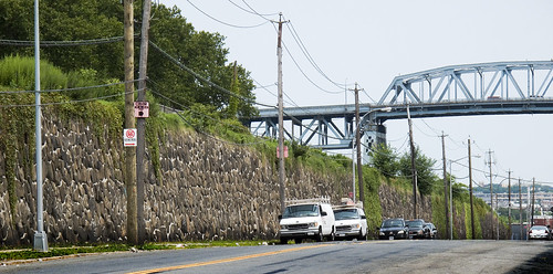
In Sunnyside, another rhiozome of the Great Machine juts eastward, carrying the 800 pound gorilla to eastern Long Island. This shot is just down the hill from the Queens Boulevard photo above labeled “Queens Blvd. looking west”, a mere 3 city blocks away. These tracks continue for miles, connecting with the brobdingnagian Jamaica Yard, and provide connections to the furthest reaches of Long Island. The tracks are elevated above the streets, and incorporate a series of bridges to span the local streets transversed. A tremendous amount of construction work is underway- as observed by your humble narrator during these endless explorations on foot- to shore up and cosmetically improve the narrow strips of land which surround the trackways. The properties had become overgrown, shoddy, and a favorite location for illicit activity and homeless camps.
from wikipedia:
The Main Line is a rail line owned and operated by the Long Island Rail Road in the U.S. state of New York. It begins in Long Island City and runs directly across the middle of Long Island, terminating in Greenport approximately 95 miles (153 km) from its starting point. Along the way, the Main Line spawns five branches. These branches, in order from west to east, are:
- Port Washington Branch (at Wood Interlocking in Woodside, Queens)
- Hempstead Branch (at Queens Interlocking along the Queens/Nassau County border)
- Oyster Bay Branch (at Nassau Interlocking in Mineola)
- Port Jefferson Branch (at Divide Interlocking in Hicksville)
- Central Branch (at Beth Interlocking at Bethpage)

entrance to the Sunnyside Yards – photo by Mitch Waxman
An entrance to the Sunnyside Yards offers a cutaway view of this Queens Plaza Great Machine complex, with the greenish steel structure bisecting the photo called to your attention. That’s Steinway Street where it becomes the 39th street (or Harold Avenue) bridge, and crosses over the Sunnyside Yard toward Queens Blvd. which is 2 blocks away ultimately terminating at 51st avenue by the BQE, just across the highway from old Calvary Cemetery which abuts the Newtown Creek. The great mills of Queens were once served by direct rail links to the Sunnyside Yard, Standard Motor’s stark industrial building with its no nonsense “daylight factory” windows is the luminous structure in the lower right corner, the Amtrak Acela barn is center, and the construction projects visible are at Queens Plaza. In the distance, Manhattan.
for a fascinating discussion of the legal status and deep history of the bridges over the Sunnyside yards, check out this article at dlapiper.com

– photo by Mitch Waxman
A garland of former industrial supremacy, the aforementioned Standard Building is just one of the enormous mills that once provided untold numbers of jobs to western Queens. Shadows, one of these giants now houses a Welfare office, and many have been converted to self storage facilities. On Northern Blvd., which is sited upon the ancient Jackson Avenue Turnpike, the Great Machine is underground. Subway tracks and other subterranean features reveal the entire surface here to be an artifice. Look at the entrance to the Sunnyside Yard shot above for the true grade of the land. This is the roof a structure, part of the Great Machine.
This Great Machine- an interconnecting system of bridges, roadways, and rail (along with power plants, sewers, and workers)- is the sum total of billions of hours of labor. When the remains of our civilization are scratched out of the sand in some future desert, one would hope that the collective work represented in this series of structures will merit some mention- a footnote next to the story of Manhattan.
from wikipedia:
NY Route 25A begins at its western terminus at Exit 13 (which is the first exit) off Interstate 495 (the Long Island Expressway) at Long Island City in the New York City borough of Queens. Route 25A is known in this area as 21st Street. As you follow 25A, it becomes Jackson Avenue and is a 4-lane road (and remains a 4-lane road well into Nassau County). Just past the intersection with Queens Boulevard (State Route 25), at the foot of the Queensboro Bridge, 25A becomes Northern Boulevard.
appy-polly-woggies, droogs
A bit of a family emergency is underway at the moment, mumsies is ill once again, and my attentions are being directed in that direction. I have a neat post in the works that will appear over the weekend, and which will surely greet you on Monday Morning.
In the meantime- congrats go out to a few dear friends of the Pentacle- Ms. Shitty, QueensCrapper, and Mr. Forgotten-NY– for their recent kudos from the Village Voice. Well deserved, and its about time that their contributions to our collective soul get recognized.

– photo by Mitch Waxman
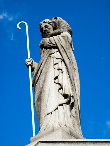
Tales of Calvary 10- The Hatch

– photo by Mitch Waxman
Your humble narrator, amongst other failings, has a certain preference for the grandiose statuary of the late 19th and early 20th century at First Calvary Cemetery here in Queens. Baroque expressions such as these appeal to the comic book fan in me, looking for all the world like a Jack Kirby or Jim Steranko rendering. One half expects a concrete angel to… well, I stray…
– photo by Mitch Waxman
The southern section of First Calvary, found atop the cyclopean masonry observed on Review Avenue, offers glimpses of the Newtown Creek and panoramic views of industrial Brooklyn. Framing the open horizon of marshy western Queens and the forges of Brooklyn is the Kosciuszko Bridge, heroically carrying a vehicular river called the Brooklyn Queens Expressway over the infamous cataract. The elevation of these walls is actually quite high, an arcing and non euclidean structure which must be 2 to 3 stories at its apogee.
Am I overestimating? Check out this shot from the “street level” declination, aimed at the downward slope from halfway down Review Ave.–
And the shots below are from the other side of it, the topside of the wall.

– photo by Mitch Waxman
You won’t find the grandiose tombs or obsequious monuments to the famous on this side of First Calvary. This is where the “regular people” are buried- in their multitudes- in neatly defined rows of plots. The northwestern sections of Calvary, where the main gates are, and the northeastern- along Laurel Hill Blvd.- (both “High Ground”) are where you can find the princes of the 19th century city. Here, along Review Avenue, is where the middle and working class rest.

– photo by Mitch Waxman
My reasons for coming to this section must remain hidden, for now, suffice to say that I am still hunting for the grave of a man named Gilman (see “Tales of Calvary 7” for more speculation on this mysterious merchant from Massachusetts). Enjoying the relative quiet, I noticed one of the concrete pillboxes which I’ve also alluded to in earlier posts. These structures are all over Calvary, are often padlocked, and have aroused no small amount of curiosity in your humble narrator.

– photo by Mitch Waxman
Several conjectures -an access point to buried family mausoleums, a storage unit for groundskeepers, some sort of equipment shed- have assailed me as I observed these structures with their heavy iron lids and stout cement construction. An avid devotee of the macabre, I’ve often wondered aloud about just what is is that may be down there.

– photo by Mitch Waxman
This particular structure, as you can see, had been left unlocked. In fact, its heavy lid was just resting on the cement and its hinges had long ago stopped functioning.

– photo by Mitch Waxman
Nudging the lid back a few inches, a better than six foot drop was observed, which put its bottom some 4 feet below the surface as observed in the shot above. I activated the camera flash and illuminated quite a bit of airborne dust when the camera performed its intended action. As you can see, there were two modern shopping carts and part of a lamp down there. Puzzling- not for being trash, but… for… why, how, when, etc. You’d expect shovels or spades, but shopping carts and a lamp?

– photo by Mitch Waxman
Were I still the youthful and robust physical specimen I once was, I might have more to say about this, as I would have entered the yawning mystery for a closer look. However, as an aged physical coward and feckless quisling given to emotional stupor and irrational panic, the miasmal odor of the open hatch drove me backwards and I nearly passed into one of my episodes. Fighting off a faint, I labored to close the heavy lid and made for the Penny Bridge gates found on Laurel Hill Blvd. to escape the implications of that smell, which reminded me of an aquarium in need of filtration.
What can it be, that might be down there?
Astoria Tumbleweeds

– photo by Mitch Waxman
The tumbling remnants of happier times rolls about the ancient village of Astoria, and can be observed in many windblown places. These urban tumbleweeds are predominantly disposed of, according to custom, before the second week of January. The majority of these shots were taken in the first week of the new year. The vast amount of trash is atypical for this block, as holiday feasting and present opening produce an abundance of urban waste.
from nyc.gov
Collections will take place beginning on Monday, January 4, 2010 through Friday, January 15, 2010 .
Residents are encouraged to put out their discarded trees at curbside as early as possible during the collection period.
DSNY asks residents to remove all tree stands, tinsel, lights, and ornaments from trees before placing them out for collection. DO NOT place trees in plastic bags. Trees will be chipped into mulch that will be distributed to parks, playing fields, and community gardens throughout the city.

– photo by Mitch Waxman
As longtime readers of this site know, I’m fascinated by New York’s infrastructure and the scale of endeavor it represents. Constantly amazed not by what the City screws up, but what it actually gets right. The extra tonnage of holiday trash, much of it paper, is just absorbed off the sidewalks without much fanfare.
The xmas trees, however, seem to be the last to be collected, which allows the wind to take them where it wants to go. Just today, during the last week of January, I saw one swirling about on the corner and there were a couple over by the local park (which is a perennial target for dumping of household trash from illegally converted area apartments).
from wikipedia
It was around Christmas 1851 when a farmer in the U.S. state of New York’s Catskill Mountains, Mark Carr, began a journey with two oxen drawn sleds toward New York City with a crop of Christmas trees in tow. When he arrived in New York the first Christmas tree market was born, from which he sold all the trees. Though Christmas trees have been sold commercially in the United States since Carr’s 1851 journey from the Catskills, the first American Christmas tree farm was not established until about 50 years later. Until then, most U.S.Christmas trees were simply harvested from forests.
from nytimes.com- click here for an article from 1880 about Mr. Carr

– photo by Mitch Waxman
Like the tumbleweeds in some stereotypical western movie, the last vestiges of ChristmAstoria just roll along and out of frame. I like to think that there’s a wall somewhere near Flushing Bay that they all pile up against, but probably not. The weather will reduce them to wireframes by Valentines Day.
from ci.nyc.ny.us
Christmas Tree Collection –
Citywide Christmas tree collection is also an important part of the Departmentʼs recycling program. In January 2008, approximately 160,250 discarded Christmas trees were collected by dedicated tree trucks over a 12-work day period, January 3 through 16, 2008. Two (2) primary disposal sites were utilized: Fresh Kills and Wards Island.
All trees delivered to Wards Island were chipped by the Department of Parks and Recreation. This joint agency partnership in processing trees proved to be extremely successful. In Fresh Kills a private company, under contract to the Department, chipped the trees.

– photo by Mitch Waxman
The sad specimen above was my own humble tree. Our Lady of the Pentacle and myself often choose the “Charlie Brown” tree for our holiday decorations.
from christmastree.org
MYTH #9: Real Christmas Trees end up in landfills.
BUSTED: Christmas Tree recycling programs are available nationwide, and many are quite creative. A farm-grown Christmas tree is 100% biodegradable, so it can be used for all kinds of things in nature, from mulch to erosion control. Fake trees?….see Myth #4 above. People often lament the sight of Christmas trees at the curb after Christmas…but they don’t realize that many communities have curb-side pick up as part of their recycling program. They’re not “being thrown in the trash” or ending up in landfills. They’re waiting to be put into the recycling program.

– photo by Mitch Waxman
Tumbling Tumbleweeds by Sons of the Pioneers- Click here for the song
I’m a roaming cowboy riding all day long,
Tumbleweeds around me sing their lonely song.
Nights underneath the prairie moon,
I ride along and sing this tune.
See them tumbling down
Pledging their love to the ground
Lonely but free I’ll be found
Drifting along with the tumbling tumbleweeds.
Cares of the past are behind
Nowhere to go but I’ll find
Just where the trail will wind
Drifting along with the tumbling tumbleweeds.
I know when night has gone
That a new world’s born at dawn.
I’ll keep rolling along
Deep in my heart is a song
Here on the range I belong
Drifting along with the tumbling tumbleweeds.
Back on the Case

– photo by Mitch Waxman
The latest batch of photos are finally finished and uploaded at flickr, most of which were shot in the last month or so. Regular postings will resume within a day or two, and your humble narrator continues to suffer the stinging embrace of winter, here in the frozen heart of the Newtown Pentacle. A ridiculous collection of insulating garments, reduced to rags by constant use, adorns my withered body and restricts movement. Just to satisfy my curious nature, I recently stepped on a bathroom scale before and after preparing for a walk, and discovered that my cold weather gear added 30 pounds to my weight- making me look like a character from a Terry Gilliam movie.
This ludicrous assortment of fleece sweatshirts, long underwear, and overcoats offers me “cover” however, as there’s little chance private security or the NYPD would notice or harass an apparently homeless man walking the fences of the Newtown Creek. When they see the camera, though, the jig is up and I’m soon explaining “what I’m up to” to another armed 24 year old from Long Island with a badge. This sort of encounter has become increasingly rare in the last year, but it still happens- and I remind the intrepid photographers amongst you to always carry ID and remember to call the young officer “Sir”. NYPD responds to polity, usually, and if you’re a gentleman they will generally realize you’re “harmless”. Never call a New York City Police Officer “dude”, respect the badge, if not the person.

– photo by Mitch Waxman
The cauldron of Astoria street life is at low simmer momentarily, as the hoodlums of the ancient village find the cold abhorrent. Our local fraternal youth organization has reorganized itself under a new “nom de guerre” and they seem to getting ready to announce their presence to the larger community this spring and summer, when- I’m sure- they will discover a few things about Queens street life. One of their lesser officers, a 90 pound weakling and runt of the litter, has been proclaiming “a storm is coming”. Their new branding incorporates the “M” word, which is never spoken aloud here in Queens, and I’m sure that certain older and long extant elements of the community will attempt to enforce rights to their intellectual property before the springtime thaw. At any rate, the local constabulary has been picking away at their loose structure and for the the moment at least- no one is dealing weed on my stoop as they’ve all landed on juvie probation.
The funniest quote from one of these kids, a 15 year old Algerian immigrant who is more “lummox teddy bear” than he is “stone cold gangsta” is that he wants to quit high school early and join the Marines. It seems that school has too many restrictions, and he thinks that the Marine Corps will offer him more freedom to pursue his interests.
Sigh.


