Archive for February 2018
long miles
Borden Avenue Bridge and environs, in today’s post.

– photo by Mitch Waxman
There have been three Borden Avenue Bridges, the first being a wooden draw bridge that opened when Borden Avenue was created in 1868. It was replaced by an iron swing bridge which was demolished in 1906, and the modern day retractile bridge was opened on the 25th of March in 1908. It cost $157, 606 to build in 1908. That would be $4,365,073 in modern money, adjusted for inflation.
A bargain, no?

– photo by Mitch Waxman
Borden Avenue Bridge is one of only two retractile bridges in NYC, the other one being the infinestimal Carroll Street Bridge over the Gowanus Canal. This specie of movable bridge is actually quite common in other cities, notably Chicago.
Chicago ain’t got a view like the one above though, I’d wager.

– photo by Mitch Waxman
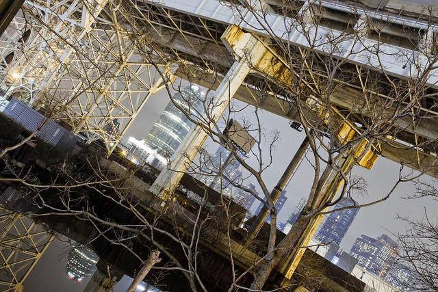
To the south of Borden Avenue, one might notice the two railroad bridges spanning Dutch Kills – Cabin M and DB Cabin. The latter carries traffic for the Lower Montauk Branch of the LIRR from the Wheelspur to Blissville Yards, all of which which are mainly used for freight these days. Cabin M connects to the Montauk Cutoff, a now severed connection to the Sunnyside Yards and the LIRR Main Line tracks.
Just beyond the two rail bridges is the main body of Newtown Creek.
– photo by Mitch Waxman
Dutch Kills itself, in this area around the Borden Avenue Bridge, is stagnant and choked with wind blown garbage. A tepid current in the water creates a vertical rather than horizontal flow pattern, which factors into the accretion of sediments on the bottom. These sediment beds, which are found across the entire Newtown Creek watershed and represent a centuries long cross section of industrial and municipal pollution, are the reason that the Creek and its tributaries are a superfund site.
At low tide, mounds of this material become exposed to the air.

– photo by Mitch Waxman
For many years, there was a shanty dwelling here, occupied by some unknown entity. Hurricane Sandy ended that tenancy.

– photo by Mitch Waxman
My chosen path next carried me eastwards on Borden Avenue, away from my beloved Creek and deeper into the post industrial landscape of Long Island City. The concrete devastations were calling to me.
“follow” me on Twitter- @newtownpentacle
quietly slipped
After dark peregrinations about the Newtown Creek.

– photo by Mitch Waxman
That’s the Hunters Point Avenue Bridge pictured above, a centuried single bascule drawbridge. Your humble narrator was actually a Parade Marshal for the centennial celebration, back in 2010. The first Hunters Point Avenue Bridge, which sat on roughly the same spot, was erected in 1874 and was made of wood. It opened and closed thanks to a mule walking on a turntable. The modern bridge is the property of the NYC Department of Transportation, and the agency has been working on the span since last summer, repairing and upgrading electronics which were damaged by Hurricane Sandy back in 2012.
The water it overflies is the Dutch Kills Tributary of the Newtown Creek, which branches off of the main waterway about 3/4 of a mile from the East River. Dutch Kills itself, in its modern incarnation, is about 3/4 of a mile long. It once ran all the way through the modern day Sunnyside Yards and fed into a marsh/swamp which would have been centered at 29th street and Jackson Avenue in LIC. That’s just before the elevated Subway breaks off to the North along 31st street and Jackson widens to become Northern Blvd.

– photo by Mitch Waxman
Over the years, one has spent a considerable amount of time along the canalized shorelines of Dutch Kills. There’s a mega structure crossing it, the truss carrying the Long Island Expressway some one hundred and six feet over the water.
November 15th of 1940 is when this section of the LIE opened, and the “high speed road” carries vehicle traffic first to the Queens Midtown Tunnel and then into Manhattan.

– photo by Mitch Waxman
Looking to the north/west, the turning basin of Dutch Kills and the remains of the Degnon Terminal.
A turning basin is an engineered section of a waterway shaped to allow an articulated tugboat and barge egress to rotate and turn around. The Degnon Terminal offered ship to rail connections back in the early 20th century, and cargo could be loaded or unloaded onto a terminal railway or onto freight cars of the Long Island Railroad for delivery to extant points.

– photo by Mitch Waxman
On the east side of Dutch Kills, the FedEx people have a large shipping depot that squats squamously. A LEED certified facility, the FedEx property nevertheless logarithmically magnifies the number of trucks worming through traffic to LIC every day from Kennedy Airport.
Semi trucks carry FedEx cargo here from the airport, delivery vans carry it out to their end customers.

– photo by Mitch Waxman
When these shots were captured, the air was terribly still. Without any sort of atmospheric perturbence, the tepid currents of Dutch Kills’ fluids barely register as a ripple on the surface.
Last time I checked, the LIE carried about 90,000 vehicle trips a day in this section (called the Queens Midtown Expressway), which translates out to around 32 million vehicles annually. The drains on the LIE are not connected to the City’s sewer system and instead drain directly into Dutch Kills. At least there’s some current, I guess.

– photo by Mitch Waxman
My path next carried the camera south to Borden Avenue.
The street dates back to 1868, when it was built as a plank road through the swamps surrounding Dutch Kills. It got its name in a traditional fashion for the 19th century, named for where it was going. It used to be the pathway to the Borden Dairy farm up the hill in Maspeth, and was constructed to allow easy egress for fresh milk to travel to market in Manhattan and beyond.
“follow” me on Twitter- @newtownpentacle
inimical oddity
Darkness continues.

– photo by Mitch Waxman
It rained all day on Sunday, whereupon a non precipitatating mist set itself up in the atmosphere during the evening hours. Given my recent fascination with wandering about the darkened Newtown Creek watershed in such conditions, a humble narrator strapped on the camera kit and debarked HQ for Long Island City. My target for this photo excursion was a section of the waterway found in Long Island City, specifically the Dutch Kills tributary.
Pictured above, looking across Skillman Avenue and the “A section” of the Sunnyside Yards towards Jackson Avenue and the Sapphire Megalith.

– photo by Mitch Waxman
A decade ago, one used to refer to this area as “Lonely Island City” since you’d seldom see anything other than a stray or lost human back here. The “zone” around the Degnon Terminal was largely deserted until recent years, when the Real Estate Industrial complex began to construct large dwellings on former industrial land along Jackson Avenue and elsewhere in LIC. All of a sudden, the humans began to appear back here.
Where can a guy go to be alone with his thoughts in Western Queens these days? Always somewhat nocturnal, a humble narrator’s solution to the presence of the human horde has simply been to shift my schedule a bit. This causes loved ones no end of worry, me wandering about in the darkness all by my lonesome.

– photo by Mitch Waxman
You’re never unobserved or truly alone in Long Island City, it should be mentioned.
In the cupola of the Sapphire Megalith, there is an impossible thing which cannot exist that is always watching you with an unblinking three lobed burning eye, after all. It hungers for profit and employs an army of acolytes to do its bidding.

– photo by Mitch Waxman
Additionally certain precautions are taken, including the usage of a reflective construction worker’s vest which is roughly worn over the filthy black raincoat. Last week, in the comments, somebody asked if I carry a firearm when I’m out at night shooting to protect myself from malign passerby who might want to rough me up in pursuance of stealing my camera or emptying my pockets. I don’t.
Were a stranger to strike me, filth and disease would crawl up their arm causing them to collapse into a pile of mouldering meat and rotting bone. That’s what I’m packing – plague and death are the horsemen I ride with.

– photo by Mitch Waxman
Atmospherically, everything was pretty much what I hoped it would be when leaving Astoria for points south and west. The mists and clouds were largely at high altitude, and only ribbons of fog were present at ground level.
My plan for the evening was to spend only a few hours wandering about, but I actually ended up being out for nearly six hours, whereupon I returned to HQ and developed the shots I had captured. One didn’t get to bed until about five in the morning, hence the late post you’re reading right now.

– photo by Mitch Waxman
One did not experience any missing time, as a note, I was working the whole time. If I was abducted by a UFO, I’m certain that shots of it would have been on my camera card when I got home. Pictured above is 29th street along the Dutch Kills turning basin, looking back at the gargantuan complex of residential luxury buildings erected within the last decade in the Court Square area of LIC.
The thing in the Megalith has won.
“follow” me on Twitter- @newtownpentacle
swam curiously
From Hells Gate.

– photo by Mitch Waxman
Whilst wiggling about and adjusting the camera settings to capture the image above, a humble narrator was photographed by the occupants of a passing minivan (which slowed down to do so) on Shore Bouelvard alongside Astoria Park last Sunday. The largish iPhone brandished at me skillfully ignored all the folks engaged in romantic congress in the front seats of their cars, or the small army of marijuana enthusiasts who were similarly situated in the parking lane. Clearly, the iPhone person had uncovered some nefarious activity being committed by a strange old man in a filthy black raincoat, and would be reporting so to the proper authorities. I was waiting for the goon squad to arrive and kick in my front door back at HQ later that night.
Mighty Triborough, and the Hell Gate Bridge, in today’s dark light post.

– photo by Mitch Waxman
There is just something about camera equipment that sets off the accent crowd here in Astoria which I’ll never understand. It’s kosher to wave your phone around wherever you go, but if they see a DSLR, it’s regarded with the same sort of caution and concern that you’d expect for brandishing an assault rifle. Given that the times I’m not carrying a camera are so rare that they are statistically irrelevant, it means that I get stared at a lot.
I’d get stared at a lot even if I wasn’t carrying the camera, as a note.

– photo by Mitch Waxman
Children gasp or cry, dogs growl, old ladies clutch at their purses… all things that happen when one such as myself scuttles past. Men puff themselves up and assume aggressive posture, police slow down and observe, security cameras pivot on their swivels. The only living creatures which do not react negatively to me are birds, and one can walk through a flock of them pecking away at the ground with nary a ruffled feather.
A few years ago, whilst wandering about, I snapped a quick photo of the facade of a local Greek church – St. Irene’s. A small mob of old Greek ladies suddenly appeared and literally chased me for about 3/4 of a mile.

– photo by Mitch Waxman
I favor atmospherics like fog for these kind of shots, normally, but for structures as massive and far reaching as Triborough and Hell Gate – fog and mist get in the way and obscure too much detail. It’s particularly dark on this section of the East River as well, which causes any sort of artificial lighting to flare due to the contrast.

– photo by Mitch Waxman
In my never ending quest to break habits, a rare vertical or portrait format shot from the “House of Moses.”

– photo by Mitch Waxman
I walked into Astoria Park to get this final shot of Hell Gate. I do wish Amtrak would light this bridge up at night.
“follow” me on Twitter- @newtownpentacle
quickened force
Cuckoo for Cocoa Puffs, me.

– photo by Mitch Waxman
Towards the end of last week, a humble narrator found himself over in the Shining City of Manhattan. I had business to discuss with somebody, mainly creating a new walking tour route, and we actually stomped out one of my proposed routes (Wall Street to 23rd street via the “East River Greenway”) after which one found himself at the NYC Ferry dock at 34th street. A quick journey across the river to Long Island City, as the burning thermonuclear eye of God itself slipped behind New Jersey, soon found me scuttling about in a Long Island City which was cloaked in preternatural darkness.
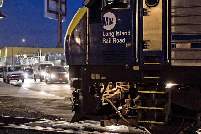
The tripod was deployed and a humble narrator got busy with the camera, which seemingly generated much interest for both private security personnel and ordinary passerby. Click, whir, click. That’s a LIRR train idling at the Hunters Point Avenue station, if you’re curious.

– photo by Mitch Waxman
The crap hole security fencing around the Sunnyside Yards doesn’t do much to actually secure the railyard, but it does get in the way of your shots. In many ways it’s a metaphor for the entire MTA. Pictured above is a long exposure of the 7 line subway exiting the Hunters Point Avenue station, and climbing onto its elevated course towards the next stop – which is the Court Square station.

– photo by Mitch Waxman
Another long exposure shot, this time from the 54th avenue footbridge over the tracks, looking westwards towards the Pulaski Bridge and the Queens Midtown tunnel. I would have waited for a train to roll by, but on my way to this spot, two LIRR units had just transited by (see below). Like a lot of the shots recently presented here, this is a narrow aperture and low ISO sensitivity photo with an exposure time of about thirty seconds.
That’s where all those light trails come from.

– photo by Mitch Waxman
I was on Borden Avenue, and heading for the 54th avenue footbridge, when the signal arms came down and the parade of LIRR rolling stock began. As a note, the shots above and below are handheld exposures, unlike the ones above.
One thing about all this night shoot stuff I’ve been up to lately is the need to be able to switch back and forth between the two strategies utilized for low light shots. In the case of these passing trains, I wanted to “freeze” the moment, so they are wide aperture and high ISO shots representing about 1/200th of a second, give or take.

– photo by Mitch Waxman
Proponents of the proposed “BQX” trolley line really should spend some time on Borden Avenue at rush hour to observe what an “at grade” crossing looks like on a well trafficked arterial street. Vehicle traffic backs up for blocks and blocks, and any traffic lanes which might intersect with the arterial begin to feel the effect of it within minutes.
As Robert Moses might have opined, it’s not about about the traffic, it’s about the flow.
– photo by Mitch Waxman
The tracks which the LIRR units are heading onto in this series are the ones you saw in the tripod shot from the 54th avenue footbridge. They lead into the Sunnyside Yards and the trains are going to be heading eastwards, I’m told, towards first Woodside and then Jamaica and then out to Nassau and Suffolk Counties.

– photo by Mitch Waxman
After unit 414 completed its journey past Borden Avenue, number 420 began its own trip. A humble narrator was squealing with glee, as a note, because simple things make me happy. After a day spent in Manhattan, which has become the most boring place on Earth, LIC welcomed me home with this grand parade?
I missed you too, Queens.
“follow” me on Twitter- @newtownpentacle


