Archive for September 2011
evasive outlines

– photo by Mitch Waxman
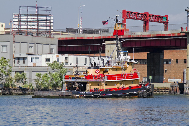
Recently, your humble narrator was assisting a colleague in the execution of a walking tour of the Newtown Creek when this tug and barge were spotted sliding across the water.
This was “the short tour”, which includes only the tiniest part of Greenpoint’s north side and includes the Newtown Creek Wastewater Treatment Plant Nature Walk.

– photo by Mitch Waxman
Esteemed, the person whom I was helping out has a rock solid grasp on the science and politics of the area, but had asked me to come along just in case anyone wanted to know who Provost Street or Kingsland Avenue are named for. That’s when I spotted this handsome scion of the McAllister towing company engaging in its occupation advancing down the Newtown Creek toward the East River.
The tugboat Resolute, side hitched to a fuel barge.

– photo by Mitch Waxman
An oft repeated but seldom comprehended statement which those of us involved with the story of this place like to throw out is “a century ago, this was the busiest waterway in North America, and the Creek carried more shipping traffic than the entire Mississippi river”. The official date for that high water mark is actually 1912, so next year we will be correct when saying century.
Your humble narrator, of course, will use the word “centuried” simply because it sounds creepy and cool.

– photo by Mitch Waxman
In times past, it wasn’t just fuel barges mind you- vast amounts of mineral products destined for manufacturers like Phelps Dodge, or barge loads of putrescents destined for corporations like Van Iderstines were common sights as late as the 1970’s along the Newtown Creek.
But- like everywhere else in New York City- nobody really makes anything these days, and even the fuel which the Resolute’s barge carries is refined elsewhere.
oh, xolotl, behave

– photo by Mitch Waxman
Another one of the topics which your humble narrator is an absolute geek about happens to involve the pre-Columbian belief systems of the aboriginal cultures which distinguished Mexico and its central American Neighbors to the south. Particularly the Aztec, or Mexica, belief system (Aztec is a spanish word) is something dear to my heart. This is mentioned so that the replete joy I felt at discovering this “cool car” on the corner of 43rd and Northern Blvd. recently might be understood.

– photo by Mitch Waxman
On the hood, or bonnet for anglicized readers, is a lovely little illustration. Ironically presented using western techniques of illustration- it nevertheless depicts an Eagle Knight and Mexica Princess framed against an imposing temple. The central skull face at the bottom of the piece is the earth monster from the “Calendar Stone of Tonatiuh”, and a full size reproduction of said sculpture may be found at the Museum of Natural History in Manhattan.
The Eagle Knights were sort of mesoamerican “Green Berets”, an elite caste of warriors distinguished by a noble birth and the use of specialized training, weapons, and tactics. The Mayan warriors depicted in the popular film “Apocalypto”, in comparison, were Jaguar Knights.

– photo by Mitch Waxman
The shining surprise on this “cool car” was found on the rear view mirrors. I’m sure that the “Ramirez” tag has some sort of modern pop cultural significance which I am unaware of, to which my only reply is “La Raza” as I sweep my spread fingers across my eyes.
Before you ask about the title of this posting- Xolotl was the name of the obsidian glass instrument which was used in the ceremonies of human sacrifice to the sun god Huitzilopochtli and the rain god Tlaoc. The Mexica considered it to be a living being.
desolate eternities

– photo by Mitch Waxman
Your humble narrator has been enlaced in several ventures which have required assiduous effort for the last several days. Promissory obligation and contractual agreement precludes revelation of the substance of these recent labors, but suffice to say that sartorial glee will abound about the Pentacle when announcements are uttered aloud.
Built in 1984, by Rayco Ship and Main Ironworks of Bourg, Louisiana as the Franklin Reinauer for Reinauer Transportation Companies of Staten Island, New York.
The Franklin Reinauer was the last tug built by the yard, after the construction of three push boats for another company, in 1985 the yard went out of business.
The tug is the second to bear the the name. The first tug that bore the name Franklin Reinauer was renamed as the Matthew Tibbetts.
She is a twin screw tug rated at 2,600 horsepower.

– photo by Mitch Waxman
Pictured in many poses and places in this posting, and presented perspicuously is the tugboat which men call the Franklin Reinauer. Often garish, the “colorway” of each tugboat company is designed to be instantly recognizable at distance. There is something lovely about the Reinauer company’s brand colors of scarlet and orange, which provides primal contrasts with the surrounding azure and cerulean waterscape of New York Harbor.
from fireboat.org
When the Coast Guard called for all assistance, some tugboats were already at the scene with others making ready to assist. The tugboat Franklin Reinauer, under Capt. Ken Peterson and followed by three other Reinauer tugboats, arrived at the Battery seawall around 1130. Peterson said he radioed the MCC aboard the pilot boat New York for permission to go to the Battery seawall to take on passengers. Seeing 10 other tugboats standing off the Battery, he radioed them to come to the seawall. “People started running for the boats and I got off and started directing traffic,” Peterson said. “The first day, we had 27 tugboats on the Battery wall and five at Pier 11.” Tugboats from Moran, McAllister, Turracamo, Reinauer, Penn Maritime, Skaugen PetroTrans, Weeks Marine and other companies responded and continued to arrive during the afternoon. “It quickly became a collaborative effort with Andy McGovern, Ken Peterson and me determining how to best employ all the resources,” Day said.
Fire-fighting efforts at Ground Zero relied heavily on water supplied by two city fireboats and a welcome addition, the ex-New York City fireboat John J. Harvey. Privately purchased by outbidding the scrap dealers in 1999, the boat had been repaired since then and docked at Hudson River Pier 63.
– photo by Mitch Waxman
Luck has placed me at enviable vantages all summer, and an enormous amount of time has been spent on and around the harbor, during which the Franklin Reinauer seemed almost a companion. Everywhere I went, it seemed the tugboat was there too. In the shots above, the Franklin Reinauer was maintaining a static position before the Pulaski Bridge on the Newtown Creek, undoubtedly awaiting the arrival of some stalwart steward of the drawbridge who would open the span and allow it further egress.
from wirednewyork.com
Newtown Creek is woven deeply into the city’s history. Until the Dutch arrived, the Maspetches Indians lived along its banks in what is now Maspeth, Queens. Some believe that Captain Kidd used a friend’s waterfront property there to stash his plunder. The creek was part of a boundary dispute from the mid- 1600’s to the mid-1700’s between Bushwick and Newtown, the precursors to Brooklyn and Queens.
But it was through commerce that the waterway came into its prime.
By the 1850’s, the creek was an industrial center that both fueled and paralleled the explosive growth of New York. Glue factories, smelting and fat-rendering plants, one of the earliest kerosene refinery and other smelly enterprises clustered along the shores of the creek and its little tributaries. The toxic sludge from these businesses got company in 1856, when the city decided to dump raw sewage directly into the water, a practice that continued for decades.
In the 1920’s and 30’s, the creek was widened to accommodate the growing traffic. In its heyday, the bridges that crossed it opened tens of thousands of times a year.
“Newtown Creek was a highway,” said Bernard Ente, a local historian. “It was just boats instead of trucks.” He estimated that 500 enterprises lined the creek at its peak. Large boats brought in raw materials and fuel and took out oil, fat, varnish, chemicals and metals.

– photo by Mitch Waxman
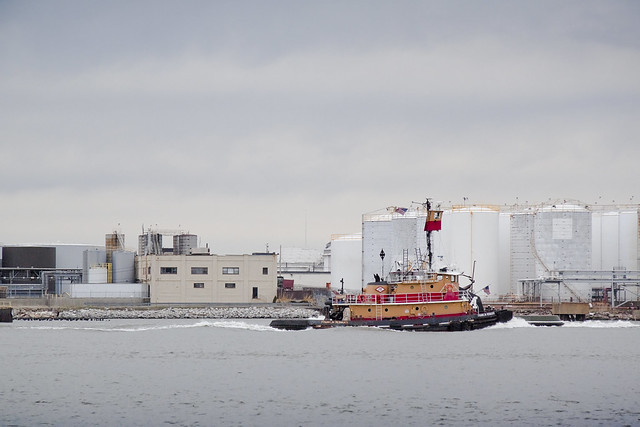
There it is again, this time in the legend choked waters off of Red Hook, and exiting the Erie Basin. A small number of Reinauer tugs and barges are often observed here at Erie Basin, which is known to most New Yorkers for the large Ikea store and NY Water Taxi Ferry service which docks here.
from pbs.org
From the mid-1800s to the mid-1900s, Red Hook’s port made it a thriving industrial neighborhood of mainly Italian and Irish American dockworkers. It was also home to one of the first Puerto Rican neighborhoods in New York City. By 1950, Red Hook had 21,000 residents, many of them longshoremen living in the Red Hook Houses, a public housing project built in 1938 to accommodate the growing number of dockworkers and their families. The neighborhood had a tough reputation—with such notorious figures as Al Capone getting their start there as small-time criminals—and its seedy side was immortalized in movies such as the On the Waterfront (1954), starring a young Marlon Brando.
When containerization shipping replaced traditional bulk shipping in the 1960s, many businesses at the Red Hook ports moved to New Jersey—as did the jobs. Unemployment increased quickly as industries abandoned Red Hook, and the neighborhood’s economy underwent a rapid decline. By the 1970s and ‘80s, it became known as being a crime-ridden, desolate neighborhood, severed from the rest of Brooklyn.

– photo by Mitch Waxman
Mundane and sometimes odd coincidences of geography, maritime, and industrial usage create an unbearable historical similarity between Red Hook and Greenpoint which are deeper and more meaningful than some merely visual verisimilitude. Just on the other side of Erie Basin is the legendary Gowanus canal, Newtown Creek’s superfund.
from brooklyncb6.org
The industrial businesses that exist in Red Hook rely on trucking as the primary way to move goods and freight into and out of the area. Heavy truck traffic has had a serious impact on the residential population and most likely contributed to infrastructure failures and the collapse of some of the older buildings in the area. The geological substrata of this coastal floodplain region contains a dense organic layer of red clay (hence the “red” in Red Hook) that exacerbates the longitudinal transmission of surface vibrations. For years efforts have been underway to reevaluate the existing Truck Route network with an eye toward minimizing its direct impact on the residential community while optimizing its intended industrial usage. The existence of truck-based solid waste transfer stations, that provide little by way of economic development of the community, has contributed to the problem of truck traffic in a major way.

– photo by Mitch Waxman
The Newtown Creek and Gowanus Canal have both been largely abandoned by those industrial forces which ruined their honor, but the tugboat has also and often been sighted in the place where these forces find modern occupation- the storied waterway called the Kill Van Kull.
Here is the Franklin Reinauer straddling this currently undefended border between New York and New Jersey.
from wikipedia
The name “Kill van Kull” has its roots in the early 17th century during the Dutch colonial era, when the region was part of New Netherland. The naming of places by early explorers and settlers during the era often referred to a location in reference to other places, its shape, its topography, and other geographic qualities. The area around the Newark Bay was called Achter Kol. The bay lies behind Bergen Hill, the emerging ridge of the Hudson Palisades which begins on Bergen Neck, the peninsula between it and the Upper New York Bay. Behind or achter the ridge, was a col or passage to the interior. Kill comes from the Middle Dutch word kille, meaning riverbed, water channel, or stream. During the British colonial era the bay was known as Cull bay.
Kill van Kull translates as channel from the pass or ridge. The name of the sister channel to the Kill van Kull, the nearby Arthur Kill, is an anglicization of achter kill meaning back channel, which would refer to its location “behind” Staten Island.
– photo by Mitch Waxman
Preparations for a vast undertaking, as mentioned in the first sentence of this evasive post, have finally been completed- a task which Sisyphus himself would have appreciated. Woe, that today I cannot accomplish my sincerest desire to announce these upcoming events. All a humble narrator can say at this moment would be:
Want to see something cool?
Bring a camera, and ID,
Follow me…
from wikipedia
Seagoing tugboats are in three basic categories:
- The standard seagoing tugboat with model bow that tows its “payload” on a hawser.
- The “notch tug” which can be secured in a notch at the stern of a specially designed barge, effectively making the combination a ship. This configuration is dangerous to use with a barge which is “in ballast” (no cargo) or in a head or following sea. Therefore, the “notch tugs” are usually built with a towing winch. With this configuration, the barge being pushed might approach the size of a small ship, the interaction of the water flow allows a higher speed with a minimal increase in power required or fuel consumption.
- The “integral unit,” “integrated tug and barge,” or “ITB,” comprises specially designed vessels that lock together in such a rigid and strong method as to be certified as such by authorities (classification societies) such as the American Bureau of Shipping, Lloyd’s Register of Shipping, Indian Register of Shipping, Det Norske Veritas or several others.These units stay combined under virtually any sea conditions and the “tugs” usually have poor sea keeping designs for navigation without their “barges” attached. Vessels in this category are legally considered to be ships rather than tugboats and barges must be staffed accordingly. These vessels must show navigation lights compliant with those required of ships rather than those required of tugboats and vessels under tow. Articulated tug and barge units also utilize mechanical means to connect to their barges. ATB’s generally utilize Intercon and Bludworth connection systems. Other available systems include Articouple, Hydraconn and Beacon Jak. ATB’s are generally staffed as a large tugboat, with between seven to nine crew members. The typical American ATB operating on the east coast, per custom, displays navigational lights of a towing vessel pushing ahead, as described in the ’72 COLREGS.
Harbor tugs. Historically tugboats were the first seagoing vessels with steam propulsion, providing freedom from the restraint of the wind. As such, they were employed in harbors to assist ships in docking and departure.
River tugs River tugs are also referred to as towboats or pushboats. Their hull designs would make open ocean operation dangerous. River tugs usually do not have any significant hawser or winch. Their hulls feature a flat front or bow to line up with the rectangular stern of the barge.
antique state

– photo by Mitch Waxman
This post gets involved with a serious bit of pondering, and will ask a naive question that I’m sure somebody else has thought of and discovered some insurmountable barrier to it’s feasibility.. Something I’ve always wondered about, even as a young but already humble narrator back during the fabled 1970’s…
Why don’t MTA trains ever carry commercial freight?

– photo by Mitch Waxman
The fabled “money train”, garbage trains, and track work flatbed cars prove that you can indeed run freight through the light rail system. Loading, and unloading, cargo is accomplished in a timely fashion. The tracks are generally not “tied up” for long by these specialty trains, nor are they chewed up by doing this kind of duty anymore than they would be during rush hour service when the cars are packed to the gills.
I’m not talking rush hour, but middle of the night sort of bulk deliveries, using a miniature form of the ocean going steel shipping container that is deployed on a specialized (non passenger car) to facilitate speedy cargo handling. How many trucks would that take off the road, and what would decoupling the local food economy from the price of gasoline do for New York City?
The subway is already a sort of distributed node network, which carries a cargo of irregularly shaped meat products from one side of the city to the other, why not just add a second class of cargo and a specialized cargo car. The beautiful part of the cargo containerization concept is that it reduces shipping down to a simple calculation of weight and measure multiplied by distance. A ton of cargo is a ton of cargo, doesn’t matter if it’s engine blocks or rice krispies, as long as it fits in a cargo container it costs the same.
Specify a small shipping container size, make it self powered and wheeled and set it to robotically roll off onto the platform where it’s programmed to and await pickup. Getting it to the sidewalk can be accomplished a half dozen different ways, and I’m not talking system wide either. Load on in Queens or the Bronx, and roll off in Manhattan- where all the trucks are coming from and going to anyway.
Why not?

– photo by Mitch Waxman
As long as the cargo is within the bulk limit of what the tracks and undercarriages are designed to do, and given the proximity to truck depot and railhead alike that so many of the outlying MTA depots enjoy, wouldn’t there be some efficacy to using the subways to move commercial goods around the city? I’m not talking bricks here, but food and dry goods delivered to where the population is densest.
Sure the setup process would be expensive, but amortizing the cost out over a generation or two can’t be that painful. Moving a case of bread or cinnamon buns from a bakery in Long Island City to a supermarket in Harlem using an already electrified third rail and a non passenger subway car which has to be cheaper than using a truck. It would certainly be better for the environment, and probably put a lot of people to work over the course of time.
It would add a new revenue stream to the MTA, and guarantee that items manufactured or cooked or just plain created within New York City were immediately advantaged over any competitors from out of town.
Just asking.
incalculable profusion

– photo by Mitch Waxman
The dizzying display of industrial and architectural might on display above distracts the eye from the subject of this post. Empire State, Chrysler, the entire shield wall of Manhattan… even that sapphire Megalith which distinguishes modern Long Island City is screaming for attention. At its base is a white building which is a former printing plant, later an Eagle Electric factory, which has been converted over to luxury condominiums known as the Arris Lofts. At the bottom of the shot is Skillman Avenue and the north side of the Sunnyside Yard with a train transiting along the tracks. In the midst of all this manifest wealth and ambition, it is easy to overlook Thomson Avenue The lower right hand corner of the shot depicts a viaduct structure which allows trains to pass beneath a vehicular roadway which it carries.
An enormous concrete and steel bridge, 500 feet long and 100 feet wide, and it is hidden in plain sight.
That’s Thomson Avenue.
from 1877’s “Long Island and where to go!!: A descriptive work compiled for the Long R.R. Co.“, courtesy google books:
Long Island City is the concentrating point upon the East river, of all the main avenues of travel from the back districts of Long Island to the city of New York. The great arteries of travel leading from New York are Thomson avenue, macadamized, 100 feet wide, leading directly to Newtown, Jamaica and the middle and southern roads on Long Island, and Jackson avenue, also 100 feet wide, and leading directly to Flushing, Whitestone and the northerly roads.
Long Island City is also the concentrating point upon the East river, of the railway system of Long Island.
The railways, upon reaching the city, pass under the main avenues of travel and traffic, and not upon or across their surface.

– photo by Mitch Waxman
To begin with, lets start with the end. Thomson disappears into the modern street grid when it is rudely interrupted by Queens Boulevard. This is the actual slam bang intersection where the “automobile city” of the 20th century meets the “locomotive city” of the 19th. Thomson avenue is centered on the other side of this tripartite intersection, where it meets Queens Boulevard and Van Dam Street.
The “Great Machine” slithers past Thomson, and hurtles eastward along the more modern thoroughfare.
from wikipedia:
Queens Boulevard was built in the early 20th century to connect the new Queensboro Bridge to central Queens, thereby offering an easy outlet from Manhattan. It was created by linking and expanding already-existing streets, such as Thomson Avenue and Hoffman Boulevard, stubs of which still exist. It was widened along with the digging of the IND Queens Boulevard Line subway tunnels in the 1920s and 1930s, and in 1941, the city proposed converting it into a freeway, as was done with the Van Wyck Expressway, but with the onset of World War II, the plan was never completed.

– photo by Mitch Waxman
Thomson adjoins Jackson Avenue on the other side of its run, where their junction forms the so called “Court Square”, which is where the Megalith squats squamously. There used to be a hospital where the colossus now stands.
from wikipedia
One Court Square, also known as the Citigroup Building, is a 50-story (209.1 meters or 686 feet) office tower in Long Island City, Queens just outside of Manhattan in New York City. It was completed in 1990 by Skidmore, Owings & Merrill LLP for Citigroup. The tower is tallest in New York City outside Manhattan, and the tallest building on Long Island. WNYZ-LP, also known as Pulse87.7 broadcasts from the top of this building.

– photo by Mitch Waxman
Overwhelming and out of character with its surroundings, the Megalith is the tallest structure on Long Island, and 53rd highest building in New York City- if you’re impressed by that sort of thing.
from nytimes.com
The building, designed by Raul de Armas of Skidmore, Owings & Merrill, is handsome, even somewhat refined; its pale blue-green glass and transparent windows are obviously intended to reduce the impact of the vast tower on Long Island City, and to a considerable extent they succeed. This building would be a lot more overpowering still if it had been sheathed in reflective glass, or garnished with ornament from top to bottom. And the shape – a tower with stepped-back corners that rises straight up for most of its height, with small setbacks at the very top to create a hint of a pyramid where the building meets the sky – helps a bit more in reducing the apparent bulk.

– photo by Mitch Waxman
Across the street from the Megalith is why they call it Court Square, the Long Island City Courthouse. Famously, this is where master criminal Willie Sutton was supposedly asked “Why do you rob banks?” and the master criminal supposedly replied “Because that’s where the money is”. According to Sutton, an urban legend. Funnily enough, the Megalith houses some of the offices of Citigroup, one of the world’s largest banks.
They don’t keep money here, though.
from nyc.gov
The Long Island City Courthouse is located near the corner of Thomson Avenue and Court Square.
In 1870, before the 1898 consolidation with New York City, the Queens county seat moved from Jamaica to the newly-formed township of Long Island City, which was near all of the train lines. Long Island City was made up of the towns of Astoria and Newtown. Abram Ditmars, the first mayor, had the streets surveyed and paved, brought in a pure water supply and established equitable tax assessments and a regular police force.
The Long Island City Courthouse was built between 1872 and 1876, with delays, scandals and cost overruns. At two-and-a-half stories, built of brick and granite in the French Second Empire style, it became one of the most important buildings in Queens. It was designed by Massachusetts architect George Hathorne. (Hathorne designed Walker Hall at Amherst College, the largest building on campus when it was built in 1870. That building was rebuilt after a fire in 1882 and was torn down 80 years later in 1962.)
The Long Island City Courthouse was gutted by a fire in 1904 and Peter M. Coco was selected to redesign it. A prominent Long Island City architect who trained at the Cooper Institute, Coco designed churches, residences and commercial buildings in the area. Using the foundations and original walls, he added two stories and stripped the building of its then-outmoded ornament, transforming it into a neoclassical style courthouse. He added projected paired Ionic columns to each side of the entrance, which support small balconies. Each has a small helmeted head between the scrolls at the top of the column. The two-story-high entrance is arched, with two dates in the spandrels: ‘1874’ and ‘1908.

– photo by Mitch Waxman
Moving in an easterly direction from Court Square, Thomson finds another connection to the automobile city, as one of the off ramps for the upper level of the Blackwell’s Island… Queensboro… Ed Koch… Bridge, allowing tens of thousands of vehicles to vomit onto Thomson’s parabola every day.
The change in grade is quite noticeable to the inveterate pedestrian, it should be mentioned.
from “Bulletin, Volumes 9-10 By Building Trades Employers’ Association“, courtesy google books
The rapid progress being made in the grading of Sunnyside yard in Long Island City, the future great terminal of the Pennsylvania Railroad system in New York, and the rapid construction of the eight massive viaducts to provide for the highway and railroad crossings, insure the completion of that section of the great undertaking early next fall.
The most massive of the overhead highway crossings is the Thomson Ave. steel viaduct, 100 feet in width and 500 feet in length, passing over the network of tracks of the Long Island and Pennsylvania Railroads at a height of 30 feet. The Queensboro Bridge extension viaduct, crossing diagonally to the street system of Long Island City, but at right angles to the railroad, is 80 feet in width, and has massive steel girders. The Thomson Ave. crossing, which will be completed next month, and the bridge extension will provide for the traffic over the main arteries of travel, extending through the borough from north to south.

– photo by Mitch Waxman
Scuttling around on the side streets which dead end off of Northern Blvd., like Dutch Kills or Queens or Purves streets, one can gain an appreciation for the height of the Thomson Avenue Viaduct. These roadway artifacts used to proceed through what is now the rail yard, and the historical record is full of lawsuits brought against the Pennsylvania Rail Road or Long Island Railroad companies for damages based on the grade situation.
These law suits detail and define the complicated questions of who owns what around and above the yards.
from 1913’s “2 years transportation progress, Volume 140“, courtesy google books
“perpetual easement or easements for the rights to continue and maintain the said viaducts or bridges over the following streets or avenues as nowlaid out or proposed: and will thereby grant to the city a perpetual easement or easements sufficient for the use and control by the city of the said viaducts and bridges for the purpose of police regulation and other control contemplated by the city ordinances for the care of streets or highways, excepting and reserving, however, to the said companies the right to construct and maintain, at its or their own expense, such connections between the said viaducts or bridges, or any of them, and the property of the said companies, as shall not interfere with the use of the said viaduets or bridges for street purposes.”
Then are specified several viaducts, and as to the one over Thomson avenue it is said:
“The said viaduct or bridge over the proposed Sunnyside Yard on the line of Thomson avenue, hereinbefore in paragraph 1C, set forth, including the right to the city to increase, at its own expense and without interfering with the operation of the said Sunnyside Yard, the width of said viaduct to beone hundred feet”
The intention of the companies was to enlarge the terminal laterally by acquiring from! the city title to the land in the closed streets wherever necessary, and by acquiring the lands abutting thereon from private owners. To do this it was necessary to close the streets across the right of way as broadened, so that the companies could have the fee and possession thereof for railroad purposes. But in some instances, and among them at Thomson avenue, in the place of the portion of the street closed and agreed to be sold a viaduct over the yard was provided and built, and it was necessarily so high over the tracks that the grade of the avenue at either end was necessarily raised to meet it. In other words, over the space where the avenue was obliterated and its bed agreed to be sold a bridge was built, and the abandoned portion made a part of the terminal facilities.

– photo by Mitch Waxman
The Sunnyside Yard tends to insulate Long Island City from the rest of western Queens, forcing its residents and businesses to pass through narrow or crowded choke points when leaving or entering the locale. The landward passages along the East River are defined by the Queensboro, while the southern ridge that overlooks the yard leads to Sunnyside. The other viaducts which cross the yards- Hunters Point Avenue, Thomson Avenue, Queens Blvd. are all orientated in a mostly easterly direction, while the the 35th street or Honeywell Bridge, and the 39th street or Harold Avenue bridge at Steinway Street offer rare and spread out pinchpoints of north south egress across the facility.
The businesses which set up shop around Sunnyside Yard in the early 20th century didn’t much care, they were part of the locomotive city.
Pictured above, one might observe the traffic barrier and pedestrian shed which manifests itself at roughly the 50% mark on the Thomson Avenue viaduct.
from 1913’s “Greater New York: bulletin of the Merchants’ Association of New York, Volume 2” courtesy google books
After luncheon, which was held in the cosy quarters of the Queens Chamber of Commerce on the Bridge Plaza, Long Island City, the party were taken on an automobile drive of about fifty miles, covering the principal points of Industrial interest in Queens.
Great Industries Established
The first stop was made on Diagonal Street which crosses the Long Island Railroad yards. From this point it is possible to see all the features of the industrial development in that part of Queens, especially the development of the Degnon Terminal Company and the new factory of the Loose-Wiles Biscuit Company.
The party then proceeded along Thompson Avenue to Newtown Creek, passing some of the largest factories in Queens, and also the most important industries in New York City, such as the Nichols Copper Company, the General Chemical Company, the National Enameling and Stamping Company, the General Vehicle Company, which is just erecting a large new building, and the Brunswick-Balke-Collender Company.

– photo by Mitch Waxman (note: for the entire post on this burning Amtrak train, click here)
The tracks which Thomson Avenue forms a bridge over are used by Long Island Railroad, Amtrak, and New Jersey Transit (which stores some of its extra daytime capacity in Sunnyside Yards between rush hours). The shot above, which was originally presented in the post Sinister Exultation, depicts an Amtrak engine having a bit of immolation trouble. The section of the yard between Hunters Point and Thomson is (or at least used to be) referred to as “Yard A”.

– photo by Mitch Waxman
From Skillman Avenue, the structure of the Thomson Avenue viaduct is visible as it’s begins to roughly slouch back to the grade level of the surrounding streets. The Sunnyside Yard allows locomotive access to the New York Connecting Railroad, which connects Long Island to the rest of the continent via the Hell Gate Bridge. Sunnyside Yard continues all the way to Woodside, and sits on an astounding 8,500 feet footprint which consumes 192 acres and offers an unbelievable 25.7 miles of track. Historical records discuss the gargantuan task of reclaiming this swampy land for use as a rail yard, as seen in the snippet below.
from 1910’s “New York tunnel extension, the Pennsylvania railroad: description of the work and facilities, Volume 2“, courtesy google books
Originally, a swamp of 40 acres extended from the present location of Honeywell Street and Jackson Avenue to Thomson Avenue, and comprised a portion of the required Yard area; the remaining 168 acres within that area was rolling ground from 10 to 70 ft. above the swamp. Upon this high ground there were 246 buildings of all kinds, and these were purchased and torn down or removed. A view of the swamp in the early stages of the work is shown by Fig. 1, Plate XLV. A vegetable growth, of the nature of peat, from 1 to 4 ft. in thickness, formed the surface of the swamp, except in the bed of Dutch Kills Creek; beneath this there was a layer of mud, and in the bed of the stream a blue-black clay of the consistency of putty. As this muck and clay would move under the pressure of the filling over it, and produce waves of considerable height, it was specified in the contract that a blanket of earth about 4 ft. thick should be first placed over this part of the Yard area, in order to prevent this wave formation. This proved efficacious, except in one or two places, where, owing to unusual depth of filling, the wave formation broke through this covering and rose to such a height as to require excavation of the peat, muck, and mud, in order to secure proper track foundations. In the bed of Meadow Street, where the embankment was very high, the crest of one of the mud waves rose to an elevation of 28 ft. above the swamp.

– photo by Mitch Waxman
The naming of Thomson avenue has always been a bit of a mystery for your humble narrator. Skillman, for instance, was named for a farmer that supported the British during the American Revolution whose lands were confiscated by the victorious rebels (much like DeLancey over in Manhattan). Apparently, there were one or two LIRR and or Pennsylvania RR executives named Thompson- and certain older documents refer to this road as “Thompson Avenue” but this is a common typographic error which favors the more widespread surname.
There was a Thomson that was an important member of the Queens Chamber of Commerce during the 1920’s but the street dates back to the beginnings of Long Island City and must be named for someone earlier.
from nycroads.com
HISTORY OF QUEENS BOULEVARD: Originally called Hoffman Boulevard, Queens Boulevard dates back to the early years of the twentieth century, when the road was constructed as a connecting route between the new Queensboro (59th Street) Bridge and central Queens. In 1913, a trolley line was constructed from 59th Street in Manhattan east along the new boulevard.
During the 1920′s and 1930′s, New York City began a program to widen Queens Boulevard. The project, which was conducted in conjunction with the building of the IND Queens Boulevard subway line, widened the boulevard to 12 lanes in some locations, and required a right-of-way of up to 200 feet. Once completed, local and express traffic flows were provided separate carriageways.


