Archive for February 2023
West End Overlook, again
Tuesday
– photo by Mitch Waxman
After spending a bit of time on Mount Washington’s Grandview Avenue shooting elevation based master shots for future usage, as described in yesterday’s post, one headed over to another elevated location known for its views. West End Overlook Park, which I’ve visited a couple of times since relocating to Pittsburgh, was my destination.
The light was kind of ‘meh’ on this visit, so instead of trying to make things look better than they did, I decided to do a few things which I don’t normally commit my time into.

– photo by Mitch Waxman
Panoramas, for instance, are seldom worth the effort. Oddly sized, I’ll shoot them and then never show them to anyone. Today’s the exception. This one was accomplished simply by loosening one of the clamp screws on my tripod and rotating the camera by about ten degrees for around eight shots which would later be merged into a single image in photoshop.
If you click the image, it’ll take you to Flickr, where you can zoom in on the thing. Like I said – an odd size which is hard to fit onto a screen. It’s even worse if you print the thing. Where are you going to find a frame that’s going to fit a print which is 39 inches wide by 10 inches tall?

– photo by Mitch Waxman
I switched out the lenses, and used the 70-300mm zoom to look up the Allegheny River. Both lenses I was using had ND filters attached, allowing me an amazing amount of control over the exposure. The light wasn’t great, but this particular set of photos was more about exercising my skills behind the camera than anything else.
One has finally replaced the desktop computer which blew up on me during the very first week of COVID, and the new unit is being put through its paces with everything that I can throw at it which the laptop I’ve been working off of for the last three years would choke up on. The laptop has been fine for photo developing and the occasional presentation, but I needed something that could do some heavy lifting to accomplish what comes ‘next.’
– photo by Mitch Waxman
I arrived at the West End Overlook park about an hour prior to sunset, and got generally busy. I popped out a bunch of these filter shots – long exposures of 15-30 seconds depending on conditions. A line of clouds was moving through the sky, creating shafts of strong sunlight and deep cloud shadows. Two or three stops of light was filtering down, and toggling on and off.
Challenging.

– photo by Mitch Waxman
I was kind of getting tired by this point, having spent my afternoon running around on Mount Washington and lugging the camera around. Already thinking about dinner back at home a few miles away in Dormont.
I was also kind of distracted by another technical challenge which I had set out for myself.
– timelapse by Mitch Waxman
The YouTube embed above has no sound, and it’s part of a “work in progress” project which the new computer is a part of. Timelapse video like the one above is a series of photos taken in intervals. In the case of the one above, I think it was a 15 second exposure followed by a four second interval followed by… rinse and repeat for about 30 minutes or so. It’s actually pretty nerve wracking and boring at the same time capturing this sort of thing. You’ve got to pay attention to the camera, but you also have to ignore it and just let it do the work.
Saying that, it’s flawed. Working on getting this technique into my toolkit, and being able to reliably produce it, that’s one of the things a humble narrator is up to while using the new computer.
Back tomorrow with something different, at your Newtown Pentacle.
“follow” me on Twitter- @newtownpentacle
Buy a book!
“In the Shadows at Newtown Creek,” an 88 page softcover 8.5×11 magazine format photo book by Mitch Waxman, is now on sale at blurb.com for $30.
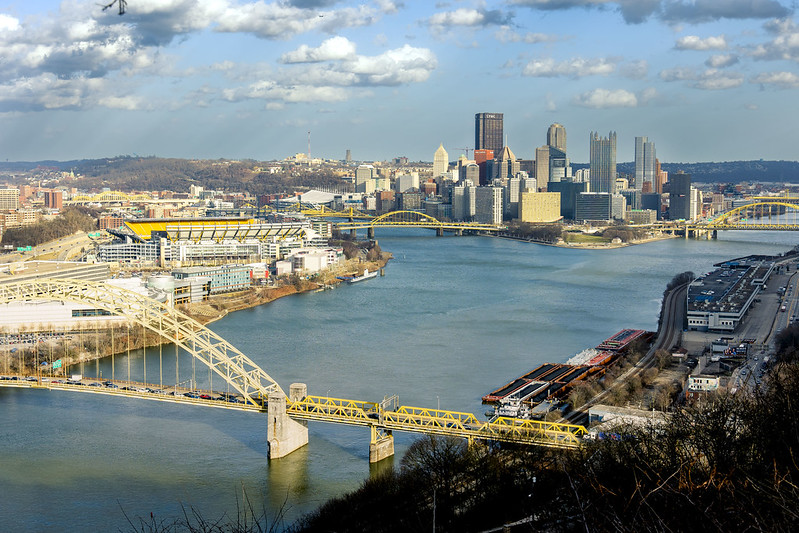
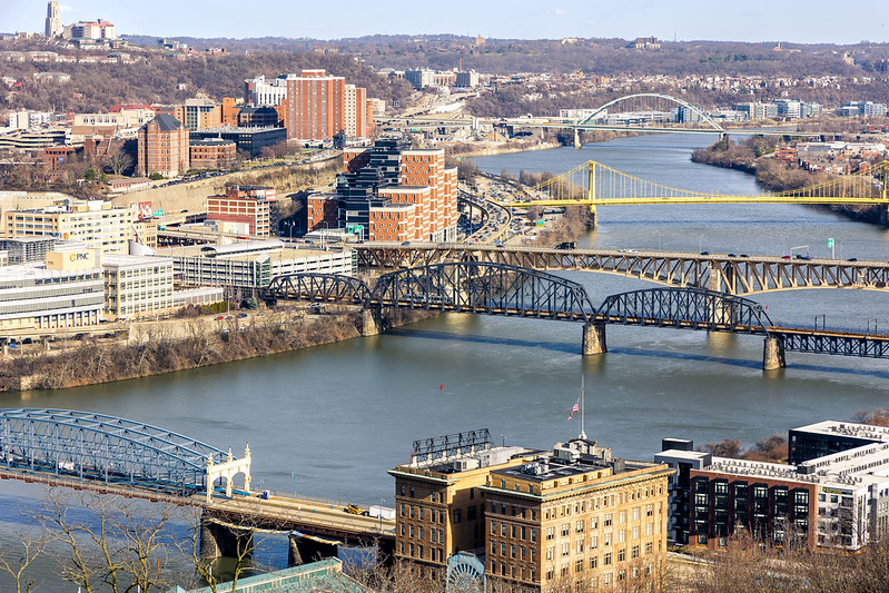
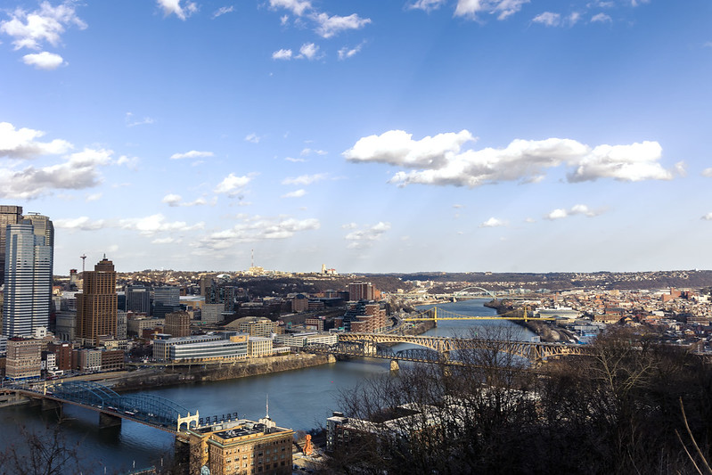
High over Pittsburgh
Monday
– photo by Mitch Waxman
Last week, an unusually warm February day found a humble narrator marching around Grandview Avenue on Mount Washington here in Pittsburgh. This street sits on a ridge overlooking Downtown Pittsburgh and the Monongahela River, and it’s bookended by the two inclines – Allegheny and Duquesne. The views from up top are fairly killer, and it should be mentioned that I’ve been here up before. There are overlook platforms, and a sort of linear park which is well used by the public, along Grandview Avenue.
The bridges in the photo above are the Fort Pitt and Fort Duquesne Bridges, both of which were recently walked over and described.
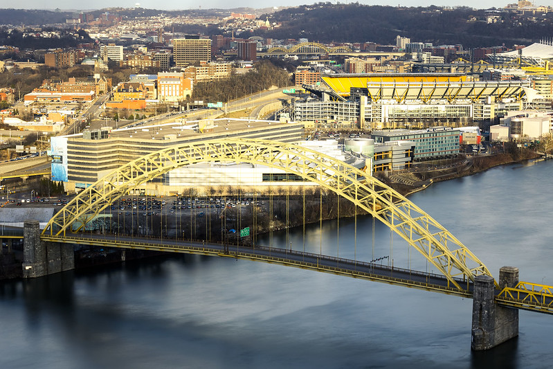
– photo by Mitch Waxman
One is – as always – fascinated by the massing shapes and parabola of the access ramps leading to and from the bridges. The water is the Monongahela River, and this is nearby the titular end of the 130 mile long waterway where it combines with the Allegheny River and the combination transmogrifies into the Ohio River.
Wanderings over the last couple of months have seen me stitching around, exploring. One was feeling the need to come back to square and reconnoiter from above.
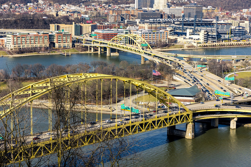
– photo by Mitch Waxman
Looking up the Monongahela River, in the foreground is the Smithfield Street Bridge and the P&LERR building. Next up is the Panhandle Bridge which carries the T light rail into Downtown. Behind that is the Liberty Bridge, and the yellow one is the South Tenth Street Bridge. In the distance, you can see the Birmingham Bridge.
All along the waterfront are ‘rail to trail’ public spaces. Between Birmingham Bridge and South Tenth Street on the north side of the river is the Eliza Furnace Trail, for instance, with the Hot Metal trail found in the south side of the water.

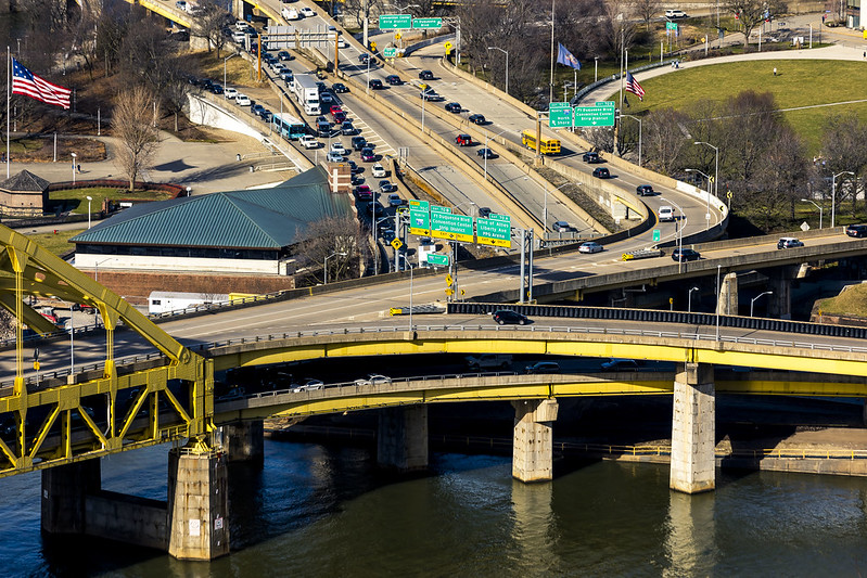
– photo by Mitch Waxman
The T is seen crossing the Panhandle Bridge in the one above. I’m planning on putting some time and spending some shoe leather on this section of the world this week, so stay tuned for that one.
I’m also planning on heading further out, specifically returning to Clairton and the trailhead of the Montour Trail found directly across the street from the sense shattering US Steel mill found in that community. I’m also planning on walking another section of the Great Allegheny Passage trail which should provide great views of USS’s Mon Valley Works in Braddock from across the river.

– photo by Mitch Waxman
This one looks back along the steep slope of Mount Washington, where the trees are still very much in their winter time hibernation mode.
Since the start of the year, there’s been a couple of very high profile crimes which resulted in the shooting death of two Police Officers in separate incidents, here in the greater Pittsburgh area, and thereby the flags have been flying at half mast throughout the City.
– photo by Mitch Waxman
One spent a couple of hours marching back and forth on Grandview Avenue, during the late afternoon. The day was coming to an end, and I wanted to do a few tripod shots, but desired to capture a less common point of view. One headed back to the Mobile Oppression Platform (my pet name for the Toyota) which had been parked at a metered spot midway twixt the two inclines, and headed towards my next destination.
The good news is that I’m finally getting comfortable with having a car be a part of the equation. Compared to having to drag ass back to HQ after walking around NYC and getting on the Subway to discover MTA is having yet another meltdown and “you can’t get there from here” it’s a real pleasure to have some personal agency in terms of getting from A to B.
Back tomorrow with what I saw and recorded.
“follow” me on Twitter- @newtownpentacle
Buy a book!
“In the Shadows at Newtown Creek,” an 88 page softcover 8.5×11 magazine format photo book by Mitch Waxman, is now on sale at blurb.com for $30.
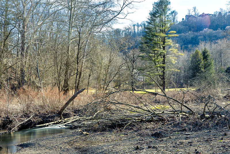
Montour Trail, part 2
Friday
– photo by Mitch Waxman
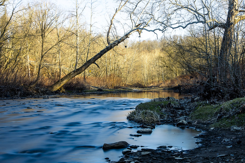
As described yesterday, one recently spent an afternoon at the head of the Montour Trail, with mile zero of the rail trail being found in the Pittsburgh suburb of Coraopolis. I scuttled from the parking lot at mile zero to about two and a half miles down the line, then turned around and headed back. Along the way, there were several interesting POV’s, so I deployed the tripod and attached a filter to my lens, and then got busy.
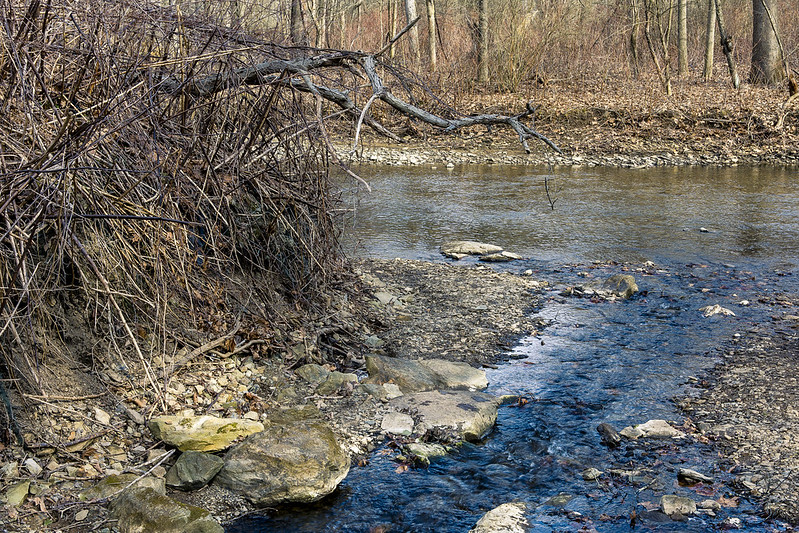
The “undistinguished” waterway seen flowing throughout today’s post is called Montour Run.

– photo by Mitch Waxman
There were lots of fallen trees in the stream. I decided to affix an ND filter to the lens to slow down the light and allow the water to photograph as a mirror. There were several ‘desire paths’ which had been created by people’s feet that led off the Montour Trail and down to the banks of the waterway.
For the most part, it was seldom more than a couple/three feet deep, but the water was flowing pretty quickly. This created a lot of visual distraction, hence the desire to “mirrorize” the surface.

– photo by Mitch Waxman
There was one area in particular which caught my attention, a basin of sorts where the water spread out nearby the overpasses of a nearby highway. For these shots, two of the legs of my tripod were actually standing in the water. I had to shimmy down a somewhat natural and quite muddy slope for these.
Worth it.

– photo by Mitch Waxman
One has been watching YouTube videos offered by bicycle riders, usually GoPro helmet cam type presentations, of Montour Trail trips. This is part of my remote scouting regime. It lets me know if there’s something specific on any one section of the trail that I might want to seek out (there are rail tunnels and bridges down the line!) and others that I’d want to avoid (the airport connector section of the Montour seems pretty horrific if you’re on foot).
Ultimately, I’m intrigued by all of this. This is EXACTLY the sort of proposal which we Newtown Creek aficionados have been proposing to the powers that be in NYC regarding the Montauk Cutoff for nearly a decade. Deaf ears, back in NYC, unless you start your sentence with “affordable housing.”
– photo by Mitch Waxman
One thing I’ve discovered here in “ridge and valley” country is that the burning thermonuclear eye of god itself may be setting at the same time or later than it does back where I’m from, but because of the terrain the sunset occurs in a quicker interval than it does in a comparatively flat and oceanic terrain. Here, the orb drops behind a hill and you’re done right quick.
Saying that, there’s some serious theatrical level lighting going on during these moments.

– photo by Mitch Waxman
One looks forward to more explorations of these amazing examples of lateral thinking, regarding the post industrial utilization and conversion of private property into a public recreational space, which can be found here in Western Pennsylvania.
Back next week with something else.
“follow” me on Twitter- @newtownpentacle
Buy a book!
“In the Shadows at Newtown Creek,” an 88 page softcover 8.5×11 magazine format photo book by Mitch Waxman, is now on sale at blurb.com for $30.
Montour Trail, part 1
Thursday

– photo by Mitch Waxman
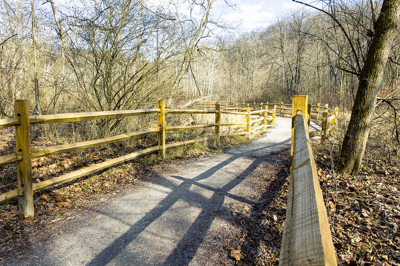
There’s a huge network of rail trails in the Pittsburgh area, something which has caught my attentions a few times. Rail Trails follow the “right of way” of some bankrupt railroad which is long gone, whereupon some combination of Governmental and community organizations converted the former trackways into public spaces and parkland. A few weeks ago, I visited a section of the Great Allegheny Passage or “GAP,” which was described here, here, and here. Additionally, visits to the Three Rivers Heritage and Hot Metal trails, as well as the Eliza Furnace Trail, are described. One is slowly becoming aware of the fairly vast network of these rail trails which snake around Pittsburgh.
Last week, I paid a visit to a suburb of Pittsburgh called Coraopolis where the Montour Trail, which follows the path of the defunct Montour Railroad, begins.
I’d visited a couple of sections of the Montour very briefly back in January, in a place called McDonald, where it intersects with another rail trail called the Panhandle. There’s also a Montour trailhead in Clairton, nearby one of the Steel Mills. Wow.

– photo by Mitch Waxman
I parked the Mobile Oppression Platform (the Toyota) at the head of the trail at a lot maintained for visitors nearby the Montour Trail’s zero mile marker. There was a Porta Potty there. One gathered the camera gear off of the back seat of the MOP and set off for a medium sized scuttle. This time around, I had two zoom lenses and a tripod with me. One lens on the camera, the other (a 70-300) in the bag. I’d say that about 75-80% were shot with my 24-105 mm lens.
Speaking of shooting, the first mile or so of the Montour Trail allows you egress between the property of two shooting ranges. For the entire first mile and a half, you’ll hear non stop rifle fire. This was excellent. There was so much gunfire going on that it sounded like a rock beat was playing. USA!

– photo by Mitch Waxman
These trails are very easy walking, and a lot of people were biking through, and most of them were sort of pleasant. The custom here is to say hello to strangers, or at least nod at them, while passing by. It’s somewhat ritualized, this friendly thing. As a lifelong New Yorker, this acknowledgment of other’s existence is weird, but when in Rome…
The surface of the trail is mostly crushed limestone but there’s patches of pavement here and there. The grading of the thing is in accordance with the railroad standard of gaining no more than one foot of elevation for every hundred feet that’s crossed horizontally, which is where that “easy walking” observation comes in. A small waterbody was running alongside the trail berm that once carried rails, called Montour Run. In places, the water looked fairly deep. Signage indicated that the run was stocked with trout. There were a bunch of informal trails leading off the Montour which people had graded with their feet. In urban design circles, these sort of corridors are called “desire paths.”
– photo by Mitch Waxman
Roughly two miles from where I started, the Montour Trail intersects with a natural conservation area and a set of side trails maintained by the Hollow Oak Land Trust. One wandered into the Hollow Oak zone for about a half hour, and enjoyed the landscape. I’m definitely coming back to this one in the spring when all of those sticks have leaves on them.
A lot of shallow water was cascading about, running down out of the woods and eventually joining the Montour Run.
– photo by Mitch Waxman
A crew of volunteers was at work when I was there, maintaining the trail and clearing brush. This was my turnaround point for the walk, as I ultimately had to back track to the zero mile point to get back to the car. The Montour Trail ultimately goes to Maryland, so it’s clearly not something I’m going to walk all in one go.
The other side trails which branch off of the Montour are going to also get some attention in the fullness of time, but as mentioned many times – one is still scouting.
– photo by Mitch Waxman
After hitting the turnaround point, roughly two and a half miles from the start, one began heading to the MOP. I had noted a few spots which were visually promising on my way to the turnaround point, and since it was now a good time of day – late afternoon – for light…
More tomorrow at this – your Newtown Pentacle.
“follow” me on Twitter- @newtownpentacle
Buy a book!
“In the Shadows at Newtown Creek,” an 88 page softcover 8.5×11 magazine format photo book by Mitch Waxman, is now on sale at blurb.com for $30.
The Hood
Wednesday
– photo by Mitch Waxman
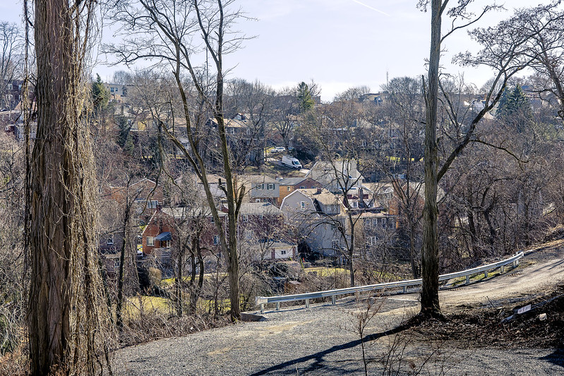
Last weekend, Our Lady of the Pentacle and myself found ourselves hanging around in the Pittsburgh suburb we landed in, which is dubbed Dormont. Given our proximity to the titular center of the City of Pittsburgh, which is about four and a half miles from here, it’s surprisingly well wooded and there’s critters all over the place. Deer, rabbits, every sort of bird you can imagine. It’s quiet and dark at night, and after midnight you can pretty much hear a pin drop. Of course, if you drop that pin, the neighborhood dog chorus is going to be forced to comment on the event.
We’ve been taking things one step at a time, and recently enjoyed a small bar crawl at several of the locals. This included what’s becoming my favorite spot – a pool hall which has a bar in it. They have Guinness on tap there, which is a bit harder to find here in Yuengling country than it was back in Irish Bar dominated Western Queens.
– photo by Mitch Waxman
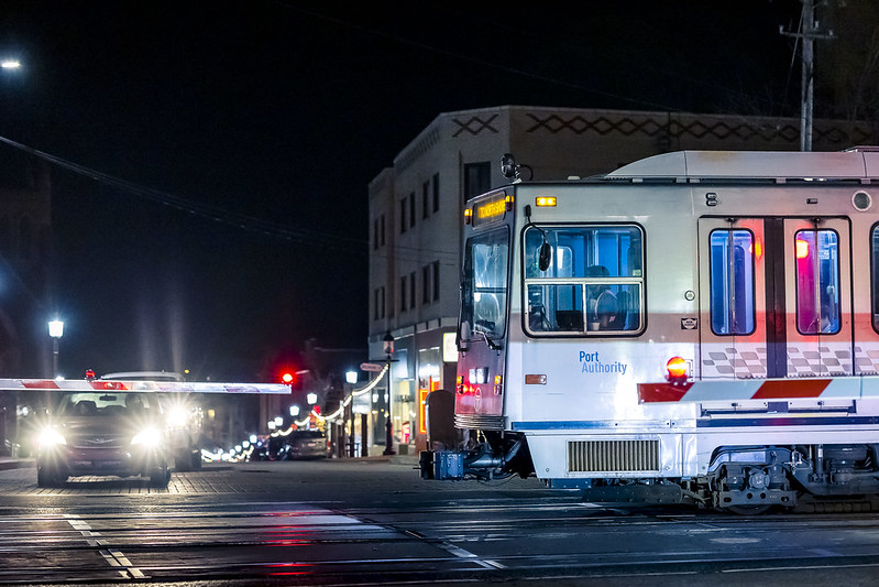
The terrain is something else, and Dormont is part of a region in Pittsburgh called the South Hills. One of the resources available here is “The T” street car line which leads directly into downtown Pittsburgh. It’s about a 20 minute ride from Dormont to downtown, and costs $2.75 for us. They use a distance based fare system for the service.
Our place is down the hill from the street which the T’s tracks are set into, and I can see the red flashing lights which signal its movement from the back deck. Thereby, I can confirm that the service is fairly frequent and you wouldn’t be waiting long for one to arrive at the station. Some of the stations are just set asides on the street, whereas others are high platform stand alone ones. The T has two sets of doors, one for the street level stops which has a set of steps, the other for the high platform ones.
– photo by Mitch Waxman
There’s a little patch of woods in a… I’m not sure it’s gulley, a hollow, or a run… but it’s a shallow valley which sometimes has water running through it right across the street from our place. It’s meant to be connected across by a wooden bridge, but I haven’t found that yet.

– photo by Mitch Waxman
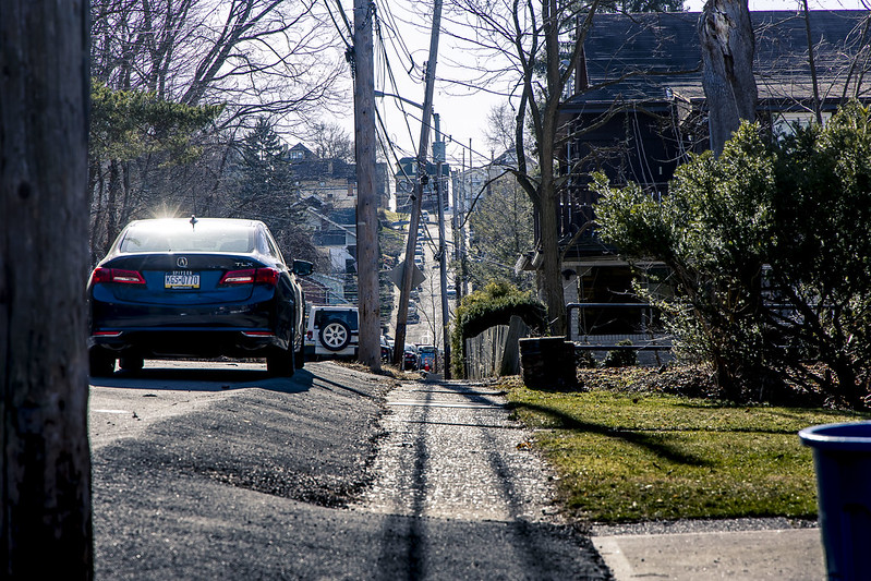
As pictured above, the terrain here is madness when you’re on foot. The locals who grew up here display super muscular legs when they’re wearing shorts. They wear shorts (with a Steelers jersey) if the temperature is anything above 40. I’ve had people ask why I’m dressed for Antarctic clime when it’s literally freezing out and I have a winter coat on. Most of the blokes I see wear fleece sweatshirts in lieu of coats, but you do spend a lot of your time getting in and out of the car in this area so it’s a practical choice.
There are hundreds and hundreds of these municipal steps all over Pittsburgh, and it’s suburbs. As time goes by, I’m planning on exploring the somewhat hidden network of these things, and seeing what they’ll show me. I’ve been planning on taking a walk along one set that overlooks freight tracks which is tolerably nearby.
Good cardio, here in Pittsburgh.
– photo by Mitch Waxman
One walk we undertook was around that gully or hollow mentioned above which is literally across the street from the house and which we haven’t gotten around to exploring yet. The street I live on dead ends about a block from my front door and then supposedly transmogrifies into a path leading towards one of those steps. We regularly see transients and never do wells heading in that direction and not coming back. According to the neighbors, there’s a quite lovely rock formation hidden back there somewhere. Maybe the corpses of all this transients we see heading in the one direction too. I’ll find it, and them, when the weather is warmer.
The ridge at the top of the hill in the shot above is where the T street car line runs, on a street dubbed “Broadway Avenue.”

– photo by Mitch Waxman
There are some truly lovely homes here, huge structures with decks and yards and multi car garages and driveways. There is not a single building style, it’s disturbingly heterogeneous.
One can confirm the “sylvania” part of the state’s name at this time. Lots of woods here.
Tomorrow – a walk along the Montour “rail to trail” is coming. Prepare!
“follow” me on Twitter- @newtownpentacle
Buy a book!
“In the Shadows at Newtown Creek,” an 88 page softcover 8.5×11 magazine format photo book by Mitch Waxman, is now on sale at blurb.com for $30.


