Archive for July 2011
suitable apparatus
– photo by Mitch Waxman
As the redolent cargo of my camera card revealed- this “Grand Walk”, a panic induced marathon which carried your humble narrator across the East River from St. Patrick’s Old Cathedral in Manhattan into Williamsburg and up Grand Street to Maspeth and the baroque intrigues of the Newtown Creek– wound down into it’s final steps on Laurel Hill Blvd.
Examining the images recorded on my camera, photos which I don’t remember taking, the ineluctable feeling that something was missing from the modern scene was inescapable.
from wikipedia
Nichols, along with his son Charles W. Nichols, helped organize the merger of 12 companies in 1899 to create General Chemical. Under his leadership, the company grew its asset base and increased its earnings threefold, making Nichols a force in America’s fledgling chemical industry. His vision of a bigger, better chemical company took off when he teamed up with investor Eugene Meyer in 1920. Nichols and Meyer combined five smaller chemical companies to create the Allied Chemical & Dye Corporation, which later became Allied Chemical Corp., and eventually became part of AlliedSignal, the forerunner of Honeywell’s specialty materials business. Both men have buildings named after them at Honeywell’s headquarters in Morristown, New Jersey. His original plant along the Newtown Creek in Queens is infamous for its legacy of pollution. Nichols is rumored to have once emptied vats of excess sulfuric acid into the creek rather than sell it cheaply to a businessman he had no respect for.

– photo by Mitch Waxman
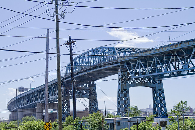
Nichols Chemical, from which the legendary Phelps Dodge Laurel Hill plant would someday sprout, would have been found along the Newtown Creek nearby the thrice damned Kosciuszko Bridge – which is itself doomed and consigned to the stuff of future reminiscence. At it’s apex, this industrial site employed 17,500 people and squatted along some 36 square acres of the Creeklands.
The tallest chimneys in the United States (at the time) stabbed at the sky from here, painting the Newtown sky with poison effluvium whose pH content was sufficient to cause marble and granite to melt like ice cream left to the merciless gaze of the burning thermonuclear eye of god itself.

– photo by Mitch Waxman
The Kosciuszko Bridge is slated for demolition and replacement in a few short years of course, and this scene will irrevocably alter when a modern structure is put in place. The high flying bridge was built large to accommodate the sort of ocean going craft which were common in the 1930’s- cargo and passenger vessels with enormous smokestacks that would have been serviced and outfitted by other corporations just up the Creek.
Additionally, the war department held certain intentions and reserved the option to sequester battleships in Newtown Creek, with the intentions of protecting the vital industrial center from a safe inlet, were an invasion of North America attempted by hostile European adversaries via New York Harbor.
When a manufacturing establishment decides to increase its output fivefold; when it decides to tear down its present buildings and put up new ones; and when it owns valuable waterfront which is marketable at a high price, that concern considers carefully the question whether it will remain in its present location or move to some other. Now our friends above mentioned would doubtless at once aver that, if this concern was a New York concern and found itself in this situation, there could be but one answer—”To Jersey for us”— or to some other place near land’s end where land can be purchased for a song, where government regulations are unknown and where, in addition, the manufacturer would find himself surrounded by a great and aching void.
But all these prophesies are as wormwood and the pessimists are confounded. Over In the wilds of Queens there Is a place—look it up on the map—called Laurel Hill.
Laurel Hill is not a place of beauty. The undulating hills in them neighborhood are covered with cemeteries, rocks, and ugly houses and through the midst of it all (lows the far-famed Newtown Creek, covered at all times during the day and night with busy water craft. But Laurel Hill is one of the most important manufacturing districts in Greater New York and Newtown Creek is one of the foremost commercial arteries in or about NewYork City.

– photo by Mitch Waxman
One of the aphorisms which has emerged in my studies of Newtown Creek and the surrounding communities is this: “all roads lead to Calvary“.
Whether it be ancient ferry lines which fed the street car roads, or the occluded pathways of the aboriginal Mespaetche and Decadent Dutch, all the roads of western Queens and North Brooklyn point inevitably to this spot. Semi conscious during this “Grand Walk”, your humble narrator nevertheless found himself at the corner of Laurel Hill Blvd. and Review Avenue once again, standing before the great and sacred Polyandrion of the Roman Catholic church in New York City.
Perhaps the foremost industry at Laurel Hill is the Nichols Copper Company. To this factory each year come by boat and by rail thousands of tons of copper, some of it in the raw state— the ore—and much of it already in bars ready for the final refining. The copper is refined here and put into a variety of forms and shapes ready for the market. The raw material comes in from the Lake Superior region, from Mexico, and even from more distant South America. The finished product goes to manufacturers in all parts of the world. The annual value of this product is over $60,000,000, and there are between seventeen hundred and eighteen hundred men engaged in converting the raw copper into the refined product which has made this factory famous tne world over.
In this factory, located within Greater New York, there is three times as much copper refined as in any other factory in the United States.

– photo by Mitch Waxman
Here lies Tammany, the Dead Rabbits, and a good percentage of those colorful characters who populated the “Bloody Sixth Ward” of the Five Points in 19th century New York. Here lies the Newsboy Governor, the “Original Gangster“, and the rightful heirs to the throne of Ireland rest within the ground consecrated by the legendary prelate called “Dagger John” alongside the “Fighting 69th” and “the 21” and the “Abbot“. Here is the secretive cruciform shaped repository which contains the remains of thousands of priests and nuns, in a catacomb which lies some 50 feet below the Almirall Chapel.
Additionally, here might be found the grave of a man who died in 1718, lying with both his descendants and his african slaves in the only Protestant burial ground entirely contained by a Catholic cemetery in North America.
And from above, that thing in the Sapphire Megalith which neither thinks nor breathes but instead hungers, watches.
from Illustrated history of the borough of Queens, New York City, 1908, courtesy google books
The Alsop family was also among the early settlers. Richard Alsop, the first of the name to locate here, came at the request of his uncle, one Thomas Wandell, who was said to have left England because he had become involved in a quarrel with Oliver Cromwell, though this report is doubtful, for it is known that Wandell was living at Mespat Kills in 1648, or before Charles I was put to death. He had secured a considerable tract of land by patents and purchase which he left to his nephew, Richard Alsop. The family he founded became extinct in 1837 when the last of the name died without issue.
pitiably inferior

– photo by Mitch Waxman
In the last posting describing this “Grand Walk” from Manhattan’s St. Patrick’s Old Cathedral to Astoria in Queens, the section of modern day Maspeth which lies between the Grand Street and Kosciuszko Bridges was offered to you as “a gateway to hell”.
Allow me to explain, and describe what happened to the towns of Berlin and Blissville.
from Annual report, Issue 4 By New York (State), 1884, courtesy google books
On the line of the Long Island city division, known as the Manhattan Beach railway, pig-styes and cow stables are numerous, and in an offensive and filthy condition.
The nuisances herein before described and found chiefly upon the Montauk division (south shore) of the Long Island railroad and upon the Long Island city division of the New York and Manhattan Beach railway.
George Aekerman’s fat boiling establishment on the flats of Newtown creek, Queens county side of it and near Metropolitan avenue, uses open kettles, presses oil from fish and renders fat from butchers’ scrap.

– photo by Mitch Waxman
Prior to the Civil War, there were two communities remote from Manhattan by the standards of the time, which earned their living agriculturally and benefitted from the vernal wonders offered by access to the Newtown Creek.
A sparkling wetland, Newtown Creek and its various tributaries spread many miles beyond their modern boundaries. Dutch Kills once extended to the foot of the Queensboro Bridge, and Maspeth Creek stretched halfway to modern day Flushing. Newtown Creek’s main body was known in the hinterlands of Bushwick, and English Kills was reported to share headwaters with the Cripplebush and Wallabout Creeks as well as its well known parent.
also from Annual report, Issue 4 By New York (State), 1884, courtesy google books
Pig-styes and cow-stables — The inspectors describe six of these nuisances as being near and a little west of the Woodside railroad station. In the first one were found sixty pigs, thirty-two cows and six goats, besides many other domestic animals.
The stables and the filthy condition of keeping manure must, if possible, be corrected. The animals are mostly kept upon “hotel swill,” which is boiled on the premises in open kettles and fed to the animals.
Grease is boiled and treated by Peter McArdles, whose premises and their contents are described as exceedingly offensive. The gases escaping from the agitators or boiler render the atmosphere of the locality offensive.
The establishment of Walter Bownes, in the woods, between the old Astoria road and Greenpoint avenue, is found to be exceedingly offensive, a reeking nuisance, where horses are killed and their remains utilized.

– photo by Mitch Waxman
When the iron road came, however, along with the great polyandrion of the Catholics- Blissville contracted toward Greenpoint Avenue, and Berlin was all but swallowed into the earth. First Mills, then Distilleries, and finally Industrial Factory complexes followed the rail and took root here. The stories of the Night Soil and Offal docks and the bone boilers and the acid manufacturers are passed down, but there are tidbits- enigmatic mentions in century old press pieces which hint at the commonplace terminology and “way that things are” that defined that world.
I read a lot of very old newspapers.
That’s how I discovered the term “Swill Milk”, and found another of those horrible facets for which the jewel called Newtown Creek is known worldwide.
from Archives of pediatrics, Volume 11, 1894 courtesy google books
The first series of experiments began August 25th, 1876, with milk obtained by several agents early in the morning from the following sources:
- Park milk, i.e.,- combined milk from a number of cows at Prospect Park. These cows were healthy, had good pasturage, and were well cared for. The milk obtained was taken from the cows in the presence of the purchaser and may be considered as equal to the best country milk.
- Rushmore’s milk, i.e., milk obtained from the Rushmore depot for milk in Brooklyn. Mr. Rushmore was one of the largest milk dealers and of good reputation. The milk furnished by him came from Queens County, L. I., and was obtained from the cows in the afternoon of the day preceding the morning of the one in which it was bought by my agent. Such milk represented very well the milk sold in cities at that time by the most reliable dealers. In 1876, little, if any, milk was shipped from dairies in bottles and with the care that is now exerted in certain quarters to keep it sweet and pure.
- Grocery milk, i.e., milk obtained from an ordinary grocery in the tenement-house district of the city. Where the milk came from and how long it had been in the grocery was not ascertained.
- Grain milk, i.e., milk obtained direct from cows through a dealer in milk living in the outskirts of the city, owning a few cows, fed almost entirely on brewers’ grains, with no pasturage except what a poor vacant lot afforded. They were poorly cared for.
- Garbage milk, i.e., milk obtained direct from cows fed on house refuse, much of which was decomposed. Cows were in the outskirts of the city and poorly cared for.
- Distillery milk, i.e., milk obtained direct from cows fed almost entirely on hot distillery slops or refuse obtained from a distillery at Blissville. These cows were in very poor condition.

– photo by Mitch Waxman
Just the other night, while regaling our Lady of the Pentacle with tales of grisly import and putrefaction over dinner, your humble narrator let slip about the so called Sludge Acid trade.
Before I go off on a Sludge Acid trip, I’d just like to note the part of Rust Street/56th Drive/Review Avenue this photo represents would have been right in the natural course of Maspeth Creek and I would be standing in about eight feet of water if this was 1811.
Remember, the ground anywhere within a mile or two of Newtown Creek in Queens was swamp and marshland, a tidal zone. The surface we walk and drive on is actually pilings and fill, and the ground water mixes freely with Creek water.
from Annual report, Volume 1 By New York. State Engineer and Surveyor, 1913
The topography of the region between Newtown creek and Flushing river shows the valley of Maspeth creek extending inland nearly to the present main line of the Long Island railroad at Winfield, and the marshes of Flushing river and its tributary Horse brook extending from Flushing bay to Grand street, Elmhurst, the valley of the latter continuing nearly to tho railroad. Another area of low marsh land, known as Train’s meadows, extends from a point in Flushing bay just south of Sanford Point and North Beach to Woodsidc. Separating tho eastern and western valleys is the ridge of glacial drift about three-quarters of a mile wide and from 40 to 50 feet high.

– photo by Mitch Waxman
OK, in the 19th century it was standard industrial practice to boil the organic or putrescent waste of Cities (dead animals, kitchen waste, rotted meat of all kinds, and human feces or “Night Soil”) in sulphuric acid in order to free valuable chemicals from the material. The waste product was called Sludge Acid, which contained all sorts of fatty residues and undigestible bits of connective tissue and filth. At Newtown Creek, where one might do whatever one’s conscience allowed one to do, it was dumped directly and untreated into the water. Most reports describe the exhaust pipes as being below the surface, so as to cause lethal gases to percolate and dissipate. Further, wherever one of these outlets might lie, an accompanying pool of the bubbling mess could be observed.
On the Brooklyn side of the Creek, back at the confluence of Metropolitan and Grand, there was a business who sent crews out to collect this free bounty and return it to their mill. They had a way to filter the stuff and concentrate the acid back into a commercial product which they would then resell or repurpose, what we’d call recycle. The fats, oils, and other nasties went back into the Creek by a delivery method of open ditches and spillways.
from anacostia.com
New York & Atlantic Railway began operation in May 1997 of the privatized concession to operate freight trains on the lines owned by Long Island Rail Road. The railway serves a diverse customer base and shares track with the densest passenger system in the United States.

– photo by Mitch Waxman
What happened to Berlin was first called Nichols Chemical, later Phelps Dodge. The copper refinery had a long history of troubles in the area, including being forced to build the tallest chimney in the Untied States to waft emanations away from surrounding neighborhoods. Phelps even went so far as to establish a “Potemkin Village” vegetable garden at the top of Berlin hill to demonstrate that their factory posed no risk to life and limb.
What happened to Blissville, however, had nothing to do with life.
In the meeting of trustees, Sept. 19, 1845, it was announced that the Alsop Farm, consisting of about 115 acres, in Newtown Township, Long Island, had been secured for a cemetery. The deeds are dated Oct. 29, 1845. On July 31, 1848, at a special meeting of the board, it was resolved that “the cemetery at Newtown Creek, recently consecrated in part, should be called Calvary, and placed at the disposal of the public; that after August 2d the 11th Street burial-ground, as well as the free vault at 50th Street, should be permanently closed.”
Calvary Cemetery began to be used August 4, 1848. The first interment was that of Esther Ennis. Sections 1, 2, 3, 4, and 5 had been previously blessed. No record is preserved, however, of the ceremony.

– photo by Mitch Waxman
Legendary are the tales of the industries which lined the shorelines of the Creek itself. Van Iderstines and Cord Meyer’s, and a dozen smaller operations which all were in the rendering or fertilizer business. An unbroken line of rotting filth, oil refineries, and distilleries extended from the Greenpoint Avenue Bridge all the way to Furman Island (at modern day Maspeth Avenue) where the greatest and worst of them all- Peter Cooper’s Glue Factory- could be found.
A third rail topic of the environmental crowd which is never discussed or mentioned is exactly what the toll of siting a cemetery might entail. Calvary Cemetery in particular went to great pains to isolate their grounds hydrologically, installing a vast system of subterrene drains, catch basins, and sewers upon the high ground of Laurel Hill. The first interment in Calvary was 1848, but the place didn’t start to fill in any great numbers before the late 1850’s. One of the least commented upon and surely grandest civil works projects of the early 19th century went on here, removing some 300 million tons of soil from the hill in the name of conquering the land.
Often, I ponder what effect the pure tonnage of decaying human meat- suffused with formaldehyde and other preservatives- means for the water table.
from The Index, Volume 5 By Free Religious Association (Boston, Mass.), 1874, courtesy google books
A single cemetery of Brooklyn,—Calvary,—the principal cemetery of the Roman Catholic Church,—there were, in a single year, nine thousand interments,—about forty per cent, of the whole city dead. The procession of hearses thither is incessant. The ground is not a large one, and the dead He there in layers three or four deep in places, the upper ones being so near the surface that the effluvium taints the air. Yet the medical inspector who gives the numbers contents himself with remarking: “The records of this city of the dead exhibit singularly instructive records of the nationalities and ages of the decedents belonging to that religious denomination!” That here is a pressing danger who will deny?
putrescent juice

– photo by Mitch Waxman
My long, indeed “Grand Walk”- a semi conscious amble whose path is revealed only by images found on my camera card sometime later- had carried me from Manhattan to the Grand Street Bridge. A revelation and totem of the political border of Queens and infinite Brooklyn, it would not be inappropriate to describe it as a former gateway to hell itself.
Not quite 100 years ago, the sky would have been black with the product of smokestacks, and every surface exposed to their fumes would be painted with a greasy residue of the worst kind of filth imaginable.
from Harper’s weekly, Volume 38, 1894- courtesy Google books
AN INSALUBRIOUS VALLEY.
The city of Brooklyn, having purged itself of the malodorous political institutions that were so long a blot upon its southern border, might well turn its attention to some nuisances of a more literally malodorous kind that flourish along its northern border, a detailed description of which will be found in another column of the Weekly’. It appears that in an early day the valley of Newtown Creek, which is the boundary between Kings and Queens counties, was selected by various manufacturers as an eligible site for the location of factories. The location was then far on the outskirts of the city, and no doubt quite unobjectionable. A great variety of institutions were set iu operation here, including those useful and necessary but unpleasant factories whose purpose it is to transform the animal refuse of a city into merchantable produce. The gases generated by these factories had an odor almost unendurable, as any one can testify who was accustomed to travel on the Long Island Railroad from the Thirty-fourth Street ferry in years gone by. But so long as railroad passengers were the only sufferers, nothing could be done to abate the nuisance, and there were for a long time no residents near to make complaint, as the growing city very naturally held back at a respectful distance from so undesirable a neighborhood.

– photo by Mitch Waxman
If one did not frequent the district, the smell would be overwhelming but the sense most offended would likely be the visual faculties. There are things which ordinary people should not see or know too much about. The customs and mores of the graveyard come to mind, and so does the imagery produced on the battlefield or on the inside of a slaughterhouse.
Amidst the farms of oil tanks and forests of chimneys, without gazing too deeply, one would notice the mounds of dead horses and dogs first- then, the tons of human shit would come into focus.
from The Sanitary Era, Volume 1, 1887, courtesy google books
Newtown Creek — No city in the Union has so foul a pest hole at its boundaries as Brooklyn. The sludge acid discharged from the works of the Standard Oil Company seems to possess an ominous potency for stirring up the sewage in the creek, and its black and thickened current seethes with bubbles of sulphuretted hydrogen. The shores, banked with this acid and with nameless filth, empoison the atmosphere at low water, while every rising tide seems to free a new supply of sludge. When to the oil industry is added the manufacture of fertilizers and a plenitude of pigs along Queens County shore, the sources of supply for a great nuisance or a grievous plague are discernible to all but official eyes and nostrils. Newtown Creek should be filled up, though not with sludge acid, and the nuisance makers removed to a distance. Our, Health Commissioner is authority for the statement that “You might as well try to fight the devil as the Standard Oil Company.”

– photo by Mitch Waxman
At this spot on the Newtown Creek, where the bone boilers and fat renderers rubbed shoulders with glue factories and manure manufacturers and acid factories, infernal mountains of organic waste materials were gathered. Necessary for the industrial pursuits of these corporate entities- the rail brought Manhattan and Brooklyn’s putrescent garbage, human waste, dead animals and anything else which once lived to them.
There was one company whose particular specialty was recovering useful chemicals from rotting cow and pig blood, produced in fantastic amounts by the armies of butchers staffing the slaughterhouses of New York and the abattoirs of Brooklyn.
No. 4—Grand Street Bridge—
The contract for the construction of this bridge was awarded to Bernard Rolf, on August 7, 1900, at an estimated cost of $173.379.90. The bridge should have been completed on October 21, 1901, but it was fourteen months later, December 26, 1902, before it could be used, and then for only part of the day; and it was not until February 5, 1903, that it was accepted and declared open for traffic.
The contractor presented claims for extra allowances, and a committee, consisting of the late Mr. C. C. Martin, Consulting Engineer; the then Deputy Commissioner, and the Engineer in Charge, reported a finding, which was accepted by the contractor and the City. The total cost of the bridge was $172,748.06.
Several important changes were found necessary in the operating machinery; New end wedges have been put in place and steel bearings have replaced certain cast-iron ones. One hand-turning gear has been installed. Stationary signal lamps, showing white and red, have been placed at the ends of the draw span. Hanging platforms have been erected at the ends of the draw span, and a platform built around the centre pier. These platforms have more than paid for themselves in the cost of repairs and erection. The railing has been painted, and the draw is working satisfactorily.

– photo by Mitch Waxman
Maspeth, troubled motherland of Queens, lays claim to this corner of the Creeklands in modernity and when exiting the Grand Street Bridge onto Grand Avenue (it changes to Avenue as it enters Queens, transmogrifies into Broadway at the heart of historic Newtown at Queens Blvd., and loops into Astoria finally terminating nearby Hallets Cove at the East River) one can say one has been there, although the lovely hills and quaint homes by which one might normally distinguish Maspeth are not present here.
Heaps of fecal matter and rotting pestilence, along with storm clouds of buzzing insects, are mentioned in first hand accounts gathered over a multiple decade period regarding this area.
from Illustrated history of the borough of Queens, New York City, 1908 courtesy google books
The untold thousands who travel every year to and from the places of amusement on the shore of the Atlantic Ocean, or to and from the large race-tracks, ride along the anything but beautiful banks of Newtown Creek, and gain from them their impression of what the borough is. This is the first impression, and therefore the strongest, and it is difficult to dispel it, for the majority of people stick to a conviction once formed, and are loath to change it, even in the face of powerful arguments. Nobody likes to admit that he was wrong or mistaken in his judgment; it is rather human to defend a position once taken.even after one has begun to doubt its correctness. And it is no exaggeration to state that perhaps ninety per cent of all the people passing through Queens Borough know nothing of it except that it contains dismal swamps, railroad yards and factories distributing evil smells and ugly to the last degree.

– photo by Mitch Waxman
Odd, the shot above and others not published indicate that my so called “Grand Walk” took an unexpected turn at this point, leaving Grand and turning North at Page Place. This is the first deviation from common street car and trolley routes which my dreaming gait carried me through.
I must have seen one of the odd cats which frequent or inhabit the area, a polydactyl line which has been mentioned in prior postings of this, your Newtown Pentacle.
from The City record, Volume 6, Part 4, 1878, courtesy google books
Newtown creek ior many years has been a source of nuisance. It receives the contents of several of the large sewers ot Brooklyn. From above Penny Bridge to the East river are factories of various descriptions, oil refiners, fat inciters, gut cleaners, distilleries, car stables, super-phosphate factories, ammonia works, varnish works, and last, but not least, immense piles of stable manure, stored for future shipment, the refuse from all of which runs into the creek, and polluting the waters to such an extent as to have killed all the fish. At low tide acres of land, covered to the depth of several inches with fat, the refuse of the oil-stills, are exposed. At high tide the oily portion of this refuse floats on the surface of the water, still giving forth its characteristic tarry odor. To add to this, many oil works, when the storage tanks are full, run their waste alkali and even their sludge-acid into the creek ; in the latter case giving rise to the well known sludge smell. During the visit of Drs. Chandler and Janeway, on the 14th inst., the material flowing from the drains at the Franklin Oil Works and at Pratt s Refinery was tested and found to be decided acid, affording proof that the sludgeacid was being discharged as above stated.
Frequently during the agitation of the oil with the oil of vitriol the covers of the agitating tanks are left open and the tfl-smefling fumes are allowed to escape into the air.
Near by are also melters boiling fat in open kettles, a method long since abandoned in New York. The stench from all these various operations is very offensive. There is a preference on the part of the manufacturers of fertilizers to manipulate the sludge-acid in the vicinity of the oil works, especially during hot weather, since it is asserted that if sludge-acid is diluted soon after its flow from the agitator, about twenty-five per cent, of it readily separates as tar, but if allowed to stand for forty eight hours in warm weather it becomes thick and ropy, the tar rises slowly and is removed with difficulty and only in small quantities. Moreover, transportation of the extra bulk of tar increases its cost to the consumer. On the other hand, as the acid is sold by yearly contract, as soon as the storage tanks are full, the refinery has no object In its further preservation and naturally allows the surplus to run into the creek.

– photo by Mitch Waxman
Imagine the scene, a century past, in this place where the industrial revolution happened. Further, let us speculate whether the bone boilers and fat renderers would sell their services as “recycling” in our modern context with it’s sophisticate euphemism. See the smoking stacks atop the mills, smell the rich perfume offered by the offal docks, hear the machines and pumps grinding away, touch the cadaverous piles of rot, taste the world which was.
Who can guess, all there is, that might be buried down there?
from Annual report of the State Board of Health of New York, 1883, courtesy google books
Simon Steinfel’s rendering establishment, which is on Furman’s island in Newtown creek (and within the limits of Newtown), gives off very offensive emanations for a long distance in the course of the railway route. Great quantities of decomposing animal matters were found upon the premises in barrels and otherwise packed in readiness for rendering.
- Kirkman & Sons’ rendering establishment, near Steinfel’s, boil and render fat and scrap in open kettles.
- At John C. Muller & Co.’s bone-black factory, at the same place as above mentioned, imported and domestic bones are burned, after being boiled in open kettles to remove all fat. The bone-tar, one of the results of bone varnish, is mixed with soft coal and burned as fuel. It is very offensive.
- C. Meyer’s bone-black factory, at the same place and of essentially the same business, is very offensive. The odor is described by the inspectors, who are expert chemists, as being extremely pungent and sickening. They say: It is doubtful if this industry can be carried on without being offensive constantly. The drainage of all these works on Furman’s island, on Newtown creek, as here described, passes out through an open ditch into the creek.
- Henry Berau’s rendering establishment on Newtown creek has the contract for removing dead animals from Brooklyn. This place is tributary to that of Preston’s, already described. His business is exceedingly offensive, and too near the populous cities and their suburbs.
- These several places are sources of constant offensiveness to railway travelers, and few have any idea of the sources whence the stenches come.
- Brooklyn Excavating Co.’s dumping of night soil is carried on near the border of Brooklyn city-lines, between Grand street and North Second street, only 300 feet from the railroad track. The stench from the nuisance is exceedingly offensive.
- Benjamin Eosenzweig’s fat rendering near Newtown creek, near the railroads, is excessively offensive, the work being carried on from seven in the evening till five in the morning.
- G. W. Baker’s fertilizer factory, close by the railroad track, between Grand street and Metropolitan avenue, is excessively offensive. It manufactures rotten bone manure, tank sediment manure and neatsfoot oil.
life, matter, and vitality

– photo by Mitch Waxman
Paramount in my apprehensions about this unremembered walk- which began at St. Patrick’s Old Cathedral, continued down Delancey Street, went over the Williamsburg Bridge, staged into Williamsburg, and continued up Grand Street in the direction of that assassination of joy called the Newtown Creek- is the ideation that something happened to me in the ancient church.
Remember, this unknown fellow from the interwebs offered me information which is dearly sought, the location of a certain interment lost in the ghoulish multitudes of Calvary Cemetery which I have spent too much time searching for. When my anonymous assignee walked into the church with two troglodyte ruffians, I panicked and fled… but a nagging suspicion that something else might have happened in there torments me.

– photo by Mitch Waxman
Could a mere intuition have sent me into this flaming paroxysm of cowardly flight, carrying me blind miles in a stupor? A delicate constitution and deep physical cowardice are my hallmarks, yes, but a multiple mile flight which propelled me across most of the eastern districts of Brooklyn? Nevertheless, according to my camera card, I had nevertheless returned to the loathsome lands of the Newtown Creek and was standing upon the Metropolitan Avenue Bridge once again.
The coincidental concurrence of my route with certain long forgotten street car (trolley) routes continues to intrigue me as I write this in the sober and controlled environment of Newtown Pentacle HQ.

– photo by Mitch Waxman
The tugboat which is often noticed here is the “Mary H.” which runs fuel barges from the outer harbor to the Bayside Oil depot located on Metropolitan Avenue itself, near it’s junction with Grand Street. The section of the Creek visible in these shots is actually a tributary, called English Kills. Two ancient pathways, which we call Grand St. and Metropolitan Avenue these days, cross each other here at a sharp angle.
Metropolitan was formerly known as the Williamsburgh and Jamaica Turnpike, and it connected Newtown in Queens with the Eastern District of Brooklyn- Bushwick, Williamsburg, and Greenpoint. The crossing of Grand and Metropolitan was also one of the stops on the New York and Manhattan Beach Railroad, its depot would have found at the foot of Greenpoint’s Quay Street in 1912.

– photo by Mitch Waxman
A theory which guides me of late requires a paradigm shift in thought and perception, simply put- the older communities of western Queens and north western Brooklyn have more in common with each other than they do with the boroughs they reside in. In earlier times, before the bridges, intimate (and railroad) ties knit these communities together and Bushwick has more in common with Astoria than it does with Flatbush.
The unifying principal, the organizing principal in fact, was access to the waterfront not just at the East River- but all along the various creeks and kills which once penetrated inland. The culture which grew along Sunswick and Newtown and Bushwick Creeks is lost to time and shifting populations, buried beneath centuries of concrete and the remnants of long vanished industry.

– photo by Mitch Waxman
It would seem that your humble narrator continued down Grand Street from Metropolitan, toward the border of Brooklyn and Queens at the Grand Street Bridge, and area I dare to call DUGSBO- Down Under the Grand Street Bridge Onramp.
This section of the City of Greater New York, incidentally, is called East Williamsburg by modern cartographers.

– photo by Mitch Waxman
Fear exists in my heart for the noble little Grand Street Bridge, as modern traffic races across it’s delicate mechanisms. Long has it been since boat traffic has crossed it, the last official opening was in 2002. One misstep by a careless trucker and this historic structure would require replacement, no doubt by an economical fixed span.
Who speaks for it, save I? It deserves a better advocate.

– photo by Mitch Waxman
An oddity and relict vehicle appears next in this fever dream found on my camera’s memory card, which is most probably a 1940 Ford Deluxe Coupe. It appears to be a loving restoration, although a powerful and enigmatic auto like this should either be painted black or fire engine red in my eyes.
What do I know, after all, I’m some guy who gets scared of strangers in the City and then wanders around the boroughs in a haze of panic and all the while I’m taking pictures that I don’t remember taking…

– photo by Mitch Waxman
It’s actually funny, considering that in this odd state which I was suffering from, that when seeking a safe haven my subconscious mind bought me here to the Newtown Creek. It has been some time since warnings and admonishments to newcomers about this place have been offered at this- your Newtown Pentacle.
Irresponsible of me, in fact.
This carrion relict of a forgotten age is not the world you know, and those rules and conventions which govern the City that encompasses it’s district do not always apply here. Trucks and railroads operate at high speed along these streets, the very air you breathe is a fume, and there are malign forces long thought dead or neutered which still thrive here. The ground is a broken minefield of powdered glass and tetanus tainted metal, and just below the surface is a writhing agglutination of the very worst stuff that the 20th century ever managed to conjure. Who can guess all there is, that might be buried down there?
Welcome to the Newtown Creek.
Note: apologies for the absent updates this last week, but the City of Water Day Newtown Creek Tour and Magic Lantern Show seriously drained my strength. To be seen by so many diminishes me.
puerile symbolism

– photo by Mitch Waxman
It’s difficult for me to not interpret what I found on my camera card for this leg of my “Grand Walk”, a panic induced fugue through starry pathways which carried me from St. Patrick’s Old Cathedral in Manhattan back to Astoria, as not being influenced by street car lines which haven’t existed since the early 20th century. These streets are relict, not that important anymore, and have served Brooklynites simply as short cuts to the bridge for quite some time. The BQE served to silence and humiliate Williamsburg mid century and nearly destroyed the place.
from the Brooklyn daily eagle almanac, courtesy google books

– photo by Mitch Waxman
By diverting traffic around Williamsburg, just as the Long Island Expressway does in the “Empty Corridor” of Long Island City, the local streets are starved of the economic benefits they once enjoyed from the Manhattan bound traffic. When still a child, the family would pack into the Plymouth periodically and head to north Brooklyn for so called “Italian cookies”. The trip was justified by the existence of relict bakeries in the area which hadn’t changed their menus in decades as no new customers were appearing.
The entire coast line of Long Island that faces the East River spent most of the 20th century asphyxiating in this manner and one man in particular is responsible for it.
from wikipedia
Robert Moses’s power increased after World War II, when, after the retirement of LaGuardia, a series of politically weak mayors consented to almost all of Moses’s proposals.Named city “construction coordinator”, in 1946, by Mayor William O’Dwyer, Moses also became the official representative of New York City in Washington, D.C. Moses was also now given powers over public housing that had eluded him under LaGuardia. Moses’s power grew even more when O’Dwyer was forced to resign in disgrace and was succeeded by Vincent R. Impellitteri, who was more than content to allow Moses to exercise control over infrastructure projects from behind the scenes.
One of Moses’s first steps after Impellitteri took office was killing the development of a city-wide Comprehensive Zoning Plan, underway since 1938, that would have restrained his nearly uninhibited power to build within the city, and removing the existing Zoning Commissioner from power. Impellitteri enabled Moses in other ways, too. Moses was now the sole person authorized to negotiate in Washington for New York City projects. He could now remake New York for the automobile. By 1959, Moses had built 28,000 apartment units on hundreds of acres. In clearing the land for high-rises in accordance with the tower in a park scheme, which at that time was seen as innovative and beneficial, he sometimes destroyed almost as many housing units as he built.
From the 1930s to the 1960s, Robert Moses was responsible for the construction of the Throgs Neck, the Bronx-Whitestone, the Henry Hudson, and the Verrazano Narrows bridges. His other projects included the Brooklyn-Queens Expressway, the Staten Island Expressway, the Cross-Bronx Expressway, the Belt Parkway, the Laurelton Parkway, and many more. Federal interest had shifted from parkway to freeway systems, and the new roads mostly conformed to the new vision, lacking the landscaping or the commercial traffic restrictions of the pre-war ones. He was the mover behind Shea Stadium and Lincoln Center, and contributed to the United Nations headquarters.

– photo by Mitch Waxman
As is the case in cities across the world, when the rents went down, crime went up. In modernity, while New York City was experiencing a serious decline in crime statistics – Nassau County and Newark experienced an explosion of illicit activity. This is a largely uncommented phenomena, of course, as the lowering of crime in NYC is largely attributed to the NYPD rather than a socioeconomic migration of problematic populations from one part of the megalopolis to another. The same is true of the “gentrified” sections of Brooklyn and Queens, when crime dropped in Long Island City- it rose in Jamaica.
Why? The rent is cheaper in Jamaica than it is in Tower Town.
from wikipedia
New York became the most populous urbanized area in the world in early 1920s, overtaking London, and the metropolitan area surpassed the 10 million mark in early 1930s, becoming the first megacity in human history. The difficult years of the Great Depression saw the election of reformer Fiorello LaGuardia as mayor and the fall of Tammany Hall after eighty years of political dominance.
Returning World War II veterans created a postwar economic boom and the development of large housing tracts in eastern Queens. New York emerged from the war unscathed as the leading city of the world, with Wall Street leading America’s place as the world’s dominant economic power. The United Nations Headquarters (completed in 1950) emphasized New York’s political influence, and the rise of abstract expressionism in the city precipitated New York’s displacement of Paris as the center of the art world.
In the 1960s, New York City began to suffer from economic problems and rising crime rates. While a resurgence in the financial industry greatly improved the city’s economic health in the 1980s, New York’s crime rate continued a steep uphill climb through the decade and into the beginning of the 1990s.[83] By the 1990s, crime rates started to drop dramatically due to increased police presence and gentrification, and many American transplants and waves of new immigrants arrived from Asia and Latin America. Important new sectors, such as Silicon Alley, emerged in the city’s economy and New York’s population reached an all-time high in the 2000 census.

– photo by Mitch Waxman
What fascinates, however, are the lost connections between the ancient villages and once upon a time cities of this original gold coast found along the River of Sound. Manhattan avenue, looking off in the direction of Greenpoint is pictured above. The street car lines which shuttled shoppers and commuters from the Grand Street Ferry back to Newtown Creek’s greatest city ran along here, and would have turned off Grand north toward Greenpoint and Long Island City via the Vernon Avenue Bridge.

– photo by Mitch Waxman
Another line would break off at Bushwick Avenue, carrying passengers south and east. Ultimately, a rider could travel all the way to Canarsie from here. Mention must be made that I’m no expert on the topic of street car lines in Brooklyn, and that the subject has only recently gained any paramount in my researches on the history and underlying structure of this- your Newtown Pentacle.
Which brings me to something I get asked a lot these days- what exactly do you mean by “Newtown Pentacle”?

– photo by Mitch Waxman
The European mind of the 17th, 18th, and early 19th century delighted in geometry and esoteric symbolism. Famously, Christopher Wren laid London’s churches and palaces out in a colossal pentagram when rebuilding from the Great Fire of London in 1666. Certainly, defensive fortifications and strategic thinking in these ages followed certain long standing geometries- stars and pentagrams especially. Washington D.C. Fulfills some freemasonic ideal of urban planning, with White House and Capitol Building occupying particular location and relationship to obelisk and parade grounds. Western Queens and North Brooklyn are no exception to this rule.
from wikipedia
Little also is known of Wren’s schooling. The story that he was at Westminster School from 1641 to 1646 is unsubstantiated. Parentalia, the biography compiled by his son, a third Christopher, places him there “for some short time” before going to Oxford (in 1650). Some of his youthful exercises preserved or recorded (though few are datable) showed that he received a thorough grounding in Latin; he also learned to draw. According to Parentalia, he was “initiated” in the principles of mathematics by Dr William Holder, who married Wren’s elder sister Susan (or Susanna) in 1643. During this time period, Wren manifested an interest in the design and construction of mechanical instruments. It was probably through Holder that Wren met Sir Charles Scarburgh whom Wren assisted in his anatomical studies.
On 25 June 1650, Wren entered Wadham College, Oxford where he studied Latin and the works of Aristotle. It is anachronistic to imagine that he received scientific training in the modern sense. However, Wren became closely associated with John Wilkins, who served as warden in Wadham. Wilkins was a member of a group of distinguished scholars. This group, whose activities led to the formation of the Royal Society, consisted of a number of distinguished mathematicians, original and sometimes brilliant practical workers and experimental philosophers. This connection probably influenced Wren’s studies of science and mathematics at college. He graduated B.A. in 1651, and three years later received M.A.

– photo by Mitch Waxman
Start a line at the Williamsburg Bridge, or let’s just call it the Wallabout. Trace it to Broadway’s intersection with Jamaica Avenue, and follow the Interboro (Jackie Robinson Parkway) to the remains of Flushing Creek at the Grand Central. Follow Grand Central north, past Strong’s Causeway, to the extant of historic Newtown in Elmhurst at “North Beach” which is modern day LaGuardia airport. Trace the line west along the original coastline of Queens to Hells Gate, and then south back to the Wallabout. This area encapsulates the entire colonial network of roads and villages which grew up isolated from the rest of the island by the Cripplebush of Brooklyn and other natural obstacles like the Flushing River, Newtown and Sunswick and Wallabout Creeks, and which developed into three of the four great municipalities of Long Island’s western coast- Greenpoint, Long Island City, and Williamsburg.
The 4th was the actual city of Brooklyn, of course, but that’s another story.
Pictured above is Morgan Avenue, where another street car would break from the Grand Street line to carry workers to the mills and factories of English Kills in the 3rd ward of Williamsburg, known to modernity as East Williamsburg. God’s gift to pain is found in this direction, and this image signals that my unremembered and unconscious walk had carried me to the Creeklands.

– photo by Mitch Waxman
The colour is noticed here, the iridescent sheen which is neither black nor white nor describable by use of any wholesome Pantone swatch. The prismatic coating which adorns every rusted fencepost and worm eaten piece of wood and the sinister faces of oddly hostile children is like nothing of this earth, rather it is like something from beyond- like a colour from space. A manifestation of dissolution and decay, this colour signals that the Newtown Creek flows lugubriously nearby.

– photo by Mitch Waxman
In this place, where Grand Street meets Metropolitan, another rail car would slip off the main line and head toward Ridgewood, while the Grand Street line would continue toward Maspeth and eventually the center of Newtown itself- crossing the creek via the Meeker Avenue, or Penny, bridge for the electric cars and Grand Street Bridge for the horse drawn.
In this place, what looks like sand is powdered automotive glass, that which appears to wholesome soil is congealed soot and ash, and the very air you breathe is a poisonous fume. Unknown aerosols drift from open sewer and automotive tailpipe mixing freely in a petrochemical haze as the burning thermonuclear eye of god itself stares down on the concrete desolation. Its emanations causes these humors and industrial liquors to combine chemically in unknown and unstudied ways- depositing more of the colour as they precipitate onto every available surface.

– photo by Mitch Waxman
It wasn’t until I saw these images on my camera card that realization set in as to where my panic induced perambulation was headed, and that I hadn’t been following trolley routes or anything normal like that. There was only one place I could be going along this route, one that millions had followed in the 19th century, a journey that started at St. Patrick’s Old Cathedral on the Lower East Side of Manhattan, crossed the River, and continued up Grand Street to it’s final destination in Queens.
For now, though, I seem to have wandered into DUMABO.
from nyc.gov
Metropolitan Avenue Bridge Over English Kills
Metropolitan Avenue is a two-way local City street in Kings and Queens Counties. The number of lanes varies from two to four along the entire length of Metropolitan Avenue, which runs east-west and extends from River Street in the Southside section of Brooklyn to Jamaica Avenue in Queens. The bridge, the only one over English Kills, carries both Metropolitan Avenue and Grand Street. The bridge is situated between Vandervoort and Varick Avenues in the East Williamsburg section of Brooklyn. The Metropolitan Avenue Bridge is a double leaf bascule bridge with a span of 33.8 m. The general appearance of the bridge has been significantly changed since it was opened in 1931. The bridge provides a channel with a horizontal clearance of 26.2 m and a vertical clearance, in the closed position, of 3.0 m at MHW and 4.6 m at MLW. The bridge structure carries a four-lane two-way vehicular roadway with sidewalks on either side. The roadway width is 16.2 m and the sidewalks are 1.8 m. There are no height restrictions on the bridge.
After the City acquired Metropolitan Avenue from the Williamsburg and Jamaica Turnpike Road Company in 1872, the existing bridge was replaced by a swing bridge, which was also used by the Broadway Ferry and Metropolitan Avenue Railroad Company. Growth in the area made the bridge inadequate by the early 20th century. The current bridge was built in 1931. Modifications since then have included upgrading the mechanical and electrical systems and the replacement of deck, bridge rail, and fenders. The stringers were replaced and new stiffeners added in 1992.


