Archive for the ‘Photowalks’ Category
into which
I been everywhere, man.

– photo by Mitch Waxman
A humble narrator is fully “back in action” after a long hermitage. In the last seven days – I’ve conducted three walking tours of the Newtown Creek watershed, visited the Kosciuszko Bridge construction project, attended and partcipated in a Working Harbor Committee tour, and have also found myself cathechizing elected officialdom about the dangers of CSO’s (Combined Sewer Outfalls). I also shot and developed a few hundred photos, and you’ll be seeing some of them over the next few days.
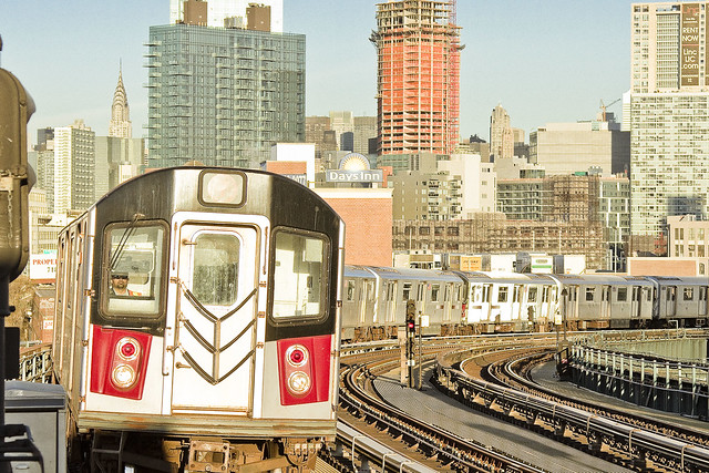
I also got to take the most photogenic of NYC’s subway lines the other day, which is the IRT Flushing or 7 line, as evinced by the shot above.

– photo by Mitch Waxman
Two of my walking tours last week were private affairs, and involved exposing groups of students to LIC. I brought the kids down the Dutch Kills tributary of Newtown Creek, then along the main stem of the Creek itself, and we eventually ended up along the East River waterfront in Hunters Point.
The counterpoints between “America’s Workshop” and the “Modern Corridor” are jarring, and seeing the post industrial section contrasted with the gentrified residential sections really seemed to hit home with them. I love taking out groups of students, incidentally, as ultimately our world will be theirs someday, and they have to start thinking up the solutions to the colossal mess we’re going to be leaving behind.

– photo by Mitch Waxman
Funnily enough, what with all the running around, I ended up walking close to forty miles last week as I scuttled around from place to place. This weekend, I’ve got another private group tour on Saturday, but on Sunday there’s a free event I’m helping to conduct with my colleague Will Elkins from Newtown Creek Alliance. Details are found below for attending the “North Henry Street Project,” which will meet up at 11 a.m on the corner of Kingsland and Norman Avenues in Greenpoint.
This one is part of the citywide MAS Janeswalk event, and I’m hoping you can come along and check out the plans NCA has been concocting for the “Unnamed Canal,” a minor tributary of Newtown Creek.
Upcoming Events and Tours
Sunday, May 8th at 11 a.m. – North Henry Street Project,
with Municipal Arts Society Janeswalk and Newtown Creek Alliance,
in Greenpoint, Brooklyn. Click here for more details.
“follow” me on Twitter- @newtownpentacle
unlimited demand
Me? I like a good arch.

– photo by Mitch Waxman
In glorious Astoria, Queens, you’ll notice that the neighborhood hosts a rail viaduct which carries the New York Connecting Railroad tracks to the Hell Gate Bridge, and that the cyclopean concrete structure uses a series of arches to carry the load. Whenever I’m out shooting, a point is made to photograph arches whenever they’re encountered, strictly in the name of “framing” for the composition. These tracks have been here since 1917, and opened in March, or possibly July of that year.
The arch is actually a relatively modern “thing” as far as human history goes, and began turning up in the built environment roughly 4,000 years ago in Mesopotamia.

– photo by Mitch Waxman
The Romans are famous for their usage of the arch and created several twists on the structural element. They would line up a series of arches to create an arcade, or twist them around a focal point to build domes. They also came up with the idea for triumphal arches, like the one you’ll find on the Canal Street side of the Manhattan Bridge, which also has a colonnade.
In case you were wondering – the Manhattan Bridge arch and colonnade were opened for inspection some five years after the bridge itself premiered. It was in 1910, a year after the bridge opened, that the architectural firm Carrère and Hastings drew the plans for the arch, and it was sculpted by Carl A. Heber. There’s also a sculptural frieze called “Buffalo Hunt” by a fellow named Charles Rumsey.

– photo by Mitch Waxman
Speaking of arches and the New York Connecting Railroad, as well as Astoria, you’d be remiss not mention the treasure of treasures which is Hell Gate. Lindenthal and Horbostel designed the great rail bridge, which is actually a series of bridges when you get down to it. The main attraction is an inverted bow spring arch.
Technically speaking, it’s called the East River Arch Bridge.
The New York Connecting Railroad Bridge, aka the East River Arch Bridge- or commonly the Hell Gate Bridge- is estimated to be the most permanent of all the structures garlanding NY Harbor. According to Discover Magazine’s Feburary 2005 issue – it would take a millennium of environmental decay for Hell Gate’s steel to fail and collapse as compared to a mere 300 years for the other East River crossings. A target of no small strategic importance, Hell Gate was a mission objective for the Nazi saboteurs who were landed in Amagansett, Long Island by a Submarine (U-Boat 202– the Innsbruck) during the second World War’s Operation Pastorius. The legal consequences of Pastorius, by the way, are the precedent setting United States Supreme Court decision of Ex Parte Quinn.
Ex Parte Quinn is the legal pretext that underpins the detention of and trial, by military tribunals, of “foreign combatants” in the United States – a central tenet of our modern Terror War.

– photo by Mitch Waxman
My favorite arches can be found at my favorite place, of course. The Greenpoint Avenue Bridge over Newtown Creek is featured above. There have been multiple bridges erected at this location over the years, but the first one was known as the “Blissville Bridge” and it was erected in 1850.
from the DOT website:
The Greenpoint Avenue Bridge is a double-leaf trunnion bascule, with 21.3m wide leaves. This bridge is a steel girder structure with a filled grid deck. The bridge provides a channel with a horizontal clearance of 45.4m and in the closed position a vertical clearance of 7.9m at MHW and 9.4m at MLW. The bridge structure carries a four-lane two-way vehicular roadway with a 1.2m striped median and sidewalks on either side. The roadway width is 8.6m and the sidewalks are 4.0m and 3.7m for the north and south sidewalk respectively. The approach roadways are narrower than the bridge roadway. The west approach and east approach roadways are 17.1m (including 1.4m center median) and 11.9m respectively.
Greenpoint Avenue Bridge is also known as the J.J. Byrne memorial bridge. Who was Byrne? Long story, click here to learn more.

– photo by Mitch Waxman
Over in Staten Island, the Bayonne Bridge opened for use to the general public was 28,856 days ago, on November 15th, 1931 at 5 A.M. Bayonne is the fourth longest steel arch bridge upon the entire planet, and was designed by Othmar Amman. Click here for more on the Bayonne Bridge, and the construction project underway which is raising its roadway to accommodate a new class of cargo vessel.
“follow” me on Twitter- @newtownpentacle
additional fact
I can’t help it if I’m “literal minded.”

– photo by Mitch Waxman
Given that I used be a “comics guy” who wrote and drew the things, there’s a certain presupposition which possesses me to interpret things in an extremely literal fashion. Given that my days and nights are spent here in Western Queens, which is famously the most diverse collection of humanity upon the entire earth, a humble narrator often finds himself in quite a pickle when signage is encountered. Some of the neighbors offer a charming interpretation of the American variant of English, after all.
I was confused by the signage in the shot above, encountered at the border of Woodside and Sunnyside. They sell Tacos, but not pets? Is the meat in the Taco not pet meat? If so, then what about the hot dogs?

– photo by Mitch Waxman
Certainty exists that the fellow who crafted the signage above intended to signal that the sidewalk was not open for its intended purpose, but one likes to assume it’s a general warning about the pavement’s proximity. On a technical note, the kerning and tracking of the letterforms adorning the missive could really use some love and attention – lousy typography is another one of my pet peeves.

– photo by Mitch Waxman
The chalk screed on the signboard pictured above wasn’t just advertising a Soccer match on Astoria’s Broadway to me, instead it was describing the last 75 years of United States foreign policy. Then again, I am literally minded as offered above, and if you put “USA vs. World” on a sign…
“follow” me on Twitter- @newtownpentacle
heavy features
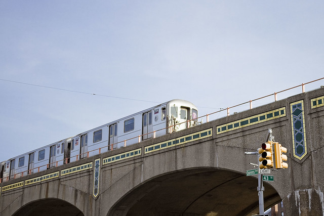
A few shots from NYC’s most photogenic subway line.

– photo by Mitch Waxman
Last week, a post was offered at this – your Newtown Pentacle – describing the 99th anniversary of the opening of the IRT Flushing Line’s Corona Extension. That’s the 11 stops between Queensboro Plaza and what’s now called 103rd Corona Plaza on the 7. My intention for that post was to show you every station, which I did in fact visit and shoot… but you know me… a week late and a dollar short.
Speaking of, I’m running a bit late today.

– photo by Mitch Waxman
Large groupings of photos – in the case of the 7 line shots, I came home with something close to a thousand individual captures which have been boiled down to around 200 – create a sort of roadblock for me. They need to be treated as one continuous shoot during the developing process (I shoot in RAW format, so every shot gets a little love and attention). Procedurally, it works like this – an initial pass to cull out over and underexposed or just junk shots, followed by key wording and then cropping. At the end of the procedural stuff I finally get to do the “developing” stage which is the photoshop equivalent of what you film people used to do in the dark room when pulling prints. Once that’s done I can finally start spawning the final incarnations of the things you see, and upload them to the web for dissemination.
When you’re starting with a thousand individual images, this ends up taking a lot of time.

– photo by Mitch Waxman
I ended up riding the 7 for several hours last week, between Willets Point and Queensboro Plaza. To me, at least, it was worth the effort.
Speaking of transit, tonight at 6:30 at Riccardos by the Bridge in Astoria, there’s a meeting to plan a centennial celebration for the Hell Gate Bridge which I intend on attending. Come with?
“follow” me on Twitter- @newtownpentacle
hath forgotten
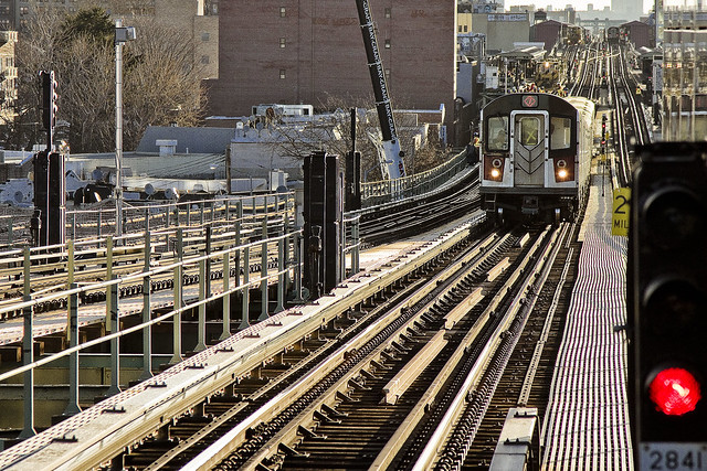
It’s 99 for the 7’s original 11.
– photo by Mitch Waxman
On April 21st, 1917 – the original 11 stops of the IRT Subway line in Queens opened for business. We call the IRT Flushing line the 7, of course. The first stops on the line in Queens – Vernon/Jackson, Hunters Point Avenue, Court Square, and Queensboro were completed a couple of years earlier – but the stretch along Queens Blvd. and Roosevelt Avenue from 33rd Rawson to 103rd Corona Plaza is 99 years old today.
The NY Times was along for that first ride – leaving Grand Central at 3 p.m. and visiting the first 11 stations of the so called Corona Extension. Check out their reportage here.
– photo by Mitch Waxman
The original names for these IRT Flushing line stops were Rawson street (33rd), Lowery street (40th), Bliss street (46th), Lincoln street (52nd), Flake street (61st), Fiske Avenue (69th), Broadway (74th), 25th avenue (82nd), Elmhurst avenue, Junction Blvd., and Alburtis avenue (103 Corona Plaza). Willets Point came online in May of 1917, and Main Street in Flushing would open in February of 1928.
– photo by Mitch Waxman
I actually spent my afternoon yesterday visiting and photographing all of these locations, but was unable to deliver the finished product in time for the anniversary this year, so archive shots of the 7 – some of which have been presented before – are here in their stead.
The historical development of western Queens from a community of farmers and dairymen to the bustling and crowded community of modernity is tied back to several watershed moments in the early 20th century. The opening of Queensboro in 1909, Sunnyside Yards in 1910, and the Steinway subway tunnels opening for business in 1907.
“follow” me on Twitter- @newtownpentacle
Walking Tour – Saturday, April 23rd, 2016 –
First Calvary Cemetery Walk.
Join Newtown Creek Alliance historian Mitch Waxman at First Calvary Cemetery, found in LIC’s Blissville neighborhood along Newtown Creek. Attendance limited to 15 people.
Click here for more info and ticketing.


