Posts Tagged ‘Long Island City’
enchanting metamorphoses

– photo by Mitch Waxman
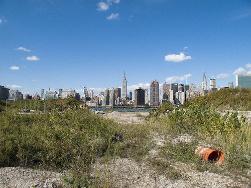
Recent announcements have heralded the formal beginnings of the process which will transmogrify the ancient Hunters Point section of Long Island City irrevocably. The support of overt interests of the Manhattan political elite have been made in public, and the financial and real estate folks are in line behind the project.
Behold, the future home of an estimated 11,000 people, imagine Tower Town.
from nyc.gov
More than 5,000 new apartments are anticipated to be constructed in the primary neighborhood character study area by 2017, including completion of the residential development at Queens West and many other mid-size residential buildings throughout the immediate area. Almost 11,000 new residents are expected in the primary study area as a result of this new construction activity.
As the primary study area (and the secondary study area, discussed below) becomes more densely developed, traffic and pedestrian volumes will increase noticeably from the current levels. Intersections throughout the area will be more congested in the morning, midday, and evening peak hours. The intersections that currently experience some congestion on Vernon Boulevard will be noticeably more congested, with some levels of service D and even LOS F, indicating high to unacceptable delays. In addition, other intersections along Vernon Boulevard in the primary study area will also have moderate to high congestion in the peak hours. On the east-west avenues in the area near the project sites (i.e., 48th, 49th, 50th, and 51st Avenues) traffic volumes are expected to increase slightly.
Pedestrian volumes will also increase in the future without the proposed actions, but sidewalks, corners, and crosswalks will generally continue to operate at acceptable levels. The crosswalk across Vernon Boulevard on the north side of 50th Avenue will, however, become noticeably congested during the morning peak hour, as people cross to enter the subway station there. This crosswalk will operate at LOS E, as will the subway stair closest to the corner (Stair S8). Buses serving the primary study area will also be noticeably more crowded.

– photo by Mitch Waxman
Direct sightlines of the heroic Manhattan skyline will be offered by these new high rise buildings, and soar over the starry old coastline that has known only industrial usage since the first Europeans arrived on the archipelago we know as New York. Its value for industry has long been exhausted, and today it is a brutal waste of land.
also from nyc.gov
The proposed actions would almost double the study area’s population. However, the proposed actions’ mix of affordable and market-rate housing could serve to relieve rather than increase residential market pressure in the study area. Additionally, given the very strong trend already in place in the neighborhood, the new population at Sites A and B would not be expected to introduce or accelerate a trend toward increased market rents in the study area that might cause significant indirect residential displacement. The redevelopment of Site B would introduce new residential uses to the Long Island City industrial area south of Borden Avenue. It is possible that the introduction of this residential use could lead to some limited indirect business displacement because of increased rent pressures. However, the potential for indirect displacement resulting from increased rent pressure is limited, and would not result in significant adverse indirect displacement impacts.

– photo by Mitch Waxman
The new development, a planned community with parks and schools, will extend far from the river- nearly all the way to the Pulaski Bridge with a basketball court and green space sited for the location of the old Vernon Avenue Bridge. The shining city of Queens, and a monument to a revolutionary and aggressive group of city planners, the story of Tower Town has begun.
also from nyc.gov
The Hunter’s Point South Rezoning and Related Actions would allow Site A and Site B to be redeveloped with largely residential buildings with building components ranging in height from
40 to 400 feet. Ground floors would include local retail, lobby, and community facility uses. On Site A, a network of new streets, sidewalks, and bikeways would be developed, creating seven new city blocks from the single 30-acre parcel it is today. Center Boulevard would be continued southward onto Site A and would connect to the rest of the street network. On Site B, it is anticipated that a new publicly accessible private road and open space would roughly bisect the site. The new residential buildings would vary in height, with bases ranging in height from 40 to 70 feet and high rise elements ranging in height from 250 to 400 feet. Nine towers would be developed on Site A, and four towers would be developed on Site B. Ground floors would be occupied by local retail and other commercial uses and community facility uses. A new public school would serve the residents of the buildings and the surrounding neighborhood and create a varied and active streetscape.
In addition, a new public waterfront park would be developed along the East River and Newtown Creek frontages of Site A and a shore public walkway would be developed along the Newtown Creek frontage of Site B. An additional linear public park would also be developed on the south side of 55th Avenue between Center Boulevard and 2nd Street, and a similar public open space would be developed on the south side of the publicly accessible private road on Parcel B, creating a wide boulevard on that street. The new waterfront parks and open spaces on Sites A and B along the East River and Newtown Creek waterfronts would provide greatly increased public access to waterfront views. Wide views of the waterfront and Manhattan would be available from locations throughout the park.
Overall, the proposed actions would change the character of Sites A and B from a commercial and industrial neighborhood to a residential neighborhood. This new residential neighborhood would incorporate retail and park uses that would attract visitors. On both Site A and Site B, pedestrian activity and vehicular activity would increase substantially over existing conditions.
– photo by Mitch Waxman
Tower Town is impossible to argue against, this real estate- former home to rail and ferry docks, and 19th century barge based casinos, and printing plants, and refineries, and power plants- is a blight on the city, and an uncomfortable reminder of that earlier time when brick strewn lots were not remarkable but common.
An economic boom in construction and real estate sales will come, when it is built. A new tax base of luxury and glamour will come to western Queens, and a wildfire of enhanced valuation will spur growth throughout surrounding riverine communities- further enhancing the economy and strengthening their own tax base- Dutch Kills first, then Astoria, and Greenpoint.
Tower Town at Hunters Point South, Atlantic Yards in Brooklyn, Flushing Commons, Willets Point, the Kosciuszko Bridge replacement.
All at once.
from “Air Quality In Queens County” at synapse-energy.com
In the interest of protecting the environment and public health of Northwest Queens, the Natural Resource Defense Council (NRDC) and the Citizens Helping Organize for a Klean Environment (CHOKE) participated in the New York State Article X permitting process for several new power plants proposed in Northwest Queens. One of their objectives was to have a study conducted to analyze the contributors to air pollution in Northwest Queens and to identify possible strategies for improving air quality and reducing risks to public health. As part of the Article X permitting process for its 250 MW Ravenswood Combined Cycle project, KeySpan committed to funding such a study as a community benefit. CHOKE and NRDC contracted with Synapse to conduct this study. The conclusions and recommendations are those of the authors but do not necessarily reflect the position of KeySpan.
One of the reasons that Queens County was chosen for this study is that it is home to many sources of air pollution. In the northwest corner of the county there currently are four large power plants, which together house 46 electric generating units. The county also contains an extensive transportation network that includes the Long Island Expressway, the Brooklyn Queens Expressway, the Grand Central Parkway, two highway bridges, a tunnel to Manhattan, and two airports, along with over 400 miles of arterial and local roads. Queens also has several large industries, and some 2.2 million residents, leading to significant economic activity which contributes to air quality problems.

– photo by Mitch Waxman
A small and insignificant scuttling thing who some might describe as a man, your humble narrator has spent a good deal of time wandering about the lonely industrial frontages of Hunters Point and expended some effort into learning its past. My opinion of this project is meaningless, it is a gathering thunderhead, and Manhattan is coming to Queens. There is just one thing that has been glossed over in mainstream reports about this place…
…this waterfront property…
from a Newtown Pentacle post of 6/7/2009
In 1697, a Dutch sea captain named Peter Praa bought the Bogardus properties and set up farming. He died in 1740, and the land was left to his granddaughter Anne Bennet. Her son, Jacob Diks, inherited next and he passed the land to his daughter- Anna Hunter. In 1817, Hunter, who had three sons, left the land to her children under the proviso that it be sold and the moneys divided evenly between them. This is why the “Mispat” became known as “Hunter’s Point”.

– photo by Mitch Waxman
For the water that promoters of this plan mention is the East River, not the water that has defined it throughout all recorded time.
from a Newtown Pentacle post of 2/28/10:
3.8 miles long, its mouth is directly opposite the Bellevue Psychiatric Hospital in Manhattan, and defines the currently undefended border between North Brooklyn and Western Queens. Estimates state that some 14 million gallons of combined sewage, storm runoff, and industrial waste provide the only flow of water into the Creek. It’s waters are opaque, and in the height of summer turn an unnatural shade of green.
The soft bottom of the waterway is 15-20 feet below the surface of the water, and the hard bottom is occluded by a gelatinous sediment known as “Black Mayonnaise”. Composed of petroleum residues, coal tar, PCB’s, and human excrement- it lies 15 feet thick on the bed. The oxygen content of the water drops precipitously as soon as one leaves the East River. The first of the drawbridges which cross it- known as the Pulaski Bridge, is the borderline beyond which immersion in this water is worthy of full HAZMAT gear and first responders institute biological decontamination procedures for anyone who finds themselves in it.
As I’ve mentioned in the past… the chemicals Putrescine (an organic chemical compound NH2(CH2)4NH2 (1,4-diaminobutane or butanediamine) and Cadaverine (a toxic diamine with the formula NH2(CH2)5NH2)which are produced by the rotting and putrefaction of animal flesh are abundantly found in the Newtown Creek under industrial aliases like Acrylonitrile and are prominent members on the EPA’s list of Volatile Organic Compounds– or VOC’s..
Who can guess, what it is, that may be buried down there?

– photo by Mitch Waxman
Tower Town, you see, will be built along the Creek as well…
…the Newtown Creek…
from epa.gov
“Newtown Creek is one of the most grossly-contaminated waterways in the country,” said Acting Regional Administrator George Pavlou. “By listing the creek, EPA can focus on doing the extensive sampling needed to figure out the best way to address the contamination and see the work through.”
EPA responded to requests by members of Congress to evaluate specific sites along the creek by publishing a September 2007 report that contained a review of past work and recommendations regarding future work at Newtown Creek. The state of New York referred the site to EPA due to the complex nature of the contamination along the creek.
Newtown Creek is part of the core area of the New York-New Jersey Harbor Estuary, which has been designated by EPA as an “estuary of national significance.” Despite the ongoing pollution problems, some residents currently use the creek for recreational purposes such as kayaking, while others catch fish for consumption out of it. Various sediment and surface water samples have been taken along the creek and reveal the presence of pesticides, metals, PCBs, and volatile organic compounds (VOCs), which are potentially harmful contaminants that can easily evaporate into the air.
In the mid -1800s, the area adjacent to the 3.8-mile Newtown Creek was one of the busiest hubs of industrial activity in New York City. More than 50 industrial facilities were located along its banks, including oil refineries, petrochemical plants, fertilizer and glue factories, sawmills, and lumber and coal yards. The creek was crowded with commercial vessels, including large boats bringing in raw materials and fuel and taking out oil, chemicals and metals. In addition to the industrial pollution that resulted from all of this activity, the city began dumping raw sewage directly into the water in 1856. During World War II, the creek was one of the busiest ports in the nation. Some factories and facilities still operate along it, and various adjacent contaminated sites have contributed to its contamination. Today, as a result of its industrial history, including countless spills, Newtown Creek is badly polluted.
Queensboro trapeze

– photo by Mitch Waxman
Oh, how I love it when they forget to close the gates…
recently observed was this aerial ballet beneath the Queensboro bridge in LIC. They seemed to either be ConEd or one of its subcontractors, busily working on some byzantine facet of… what I suspect… to be the steam pipes that follow the underside of the great bridge from the Ravenswood Station (aka Big Allis) to Manhattan.
from wikipedia
The New York City steam system is a district heating system which carries steam from central power stations under the streets of Manhattan to heat, cool, or supply power to high rise buildings and businesses. Some New York businesses and facilities also use the steam for cleaning and disinfection.
The New York Steam Company began providing service in lower Manhattan in 1882. Today, Consolidated Edison operates the largest commercial steam system in the world, now known as Con Edison Steam Operations, providing steam service to nearly 2,000 customers and serving more than 100,000 commercial and residential establishments in Manhattan from the Battery at the southern tip of Manhattan to 96th Street uptown. Roughly 30 billion lbs. (just under 13.64 megatons) of steam flow through the system every year.

– photo by Mitch Waxman
Pithy comments were overheard from the crew’s supervisor regarding your humble narrator, and I can’t necessarily blame them. Who wants to be photographed by some stranger while at work?
from wikipedia
In 1823, Con Edison’s earliest corporate entity, the New York Gas Light Company, was founded by a consortium of New York City investors. In 1824 New York Gas Light was listed on the New York Stock Exchange, it has the record for being the longest listed stock on the NYSE.
In 1884, six gas companies combined into the Consolidated Gas Company. The New York Steam Company began providing service in lower Manhattan in 1882. Today, Con Edison operates the largest commercial steam system in the world, providing steam service to nearly 1,600 commercial and residential establishments in Manhattan from the Battery to 96th Street.
Con Edison’s electric business also dates back to 1882, when Thomas Edison’s Edison Electric Illuminating Company of New York began supplying electricity to 59 customers in a square-mile area in lower Manhattan. After the “War of Currents”, there were more than 30 companies generating and distributing electricity in New York City and Westchester County. But by 1920 there were far fewer, and the New York Edison Company (then part of Consolidated Gas) was clearly the leader.
In 1936, with electric sales far outstripping gas sales, the company incorporated and the name was changed to Consolidated Edison Company of New York, Inc. The years that followed brought further amalgamations as Consolidated Edison acquired or merged with more than a dozen companies between 1936 and 1960. Con Edison today is the result of acquisitions, dissolutions and mergers of more than 170 individual electric, gas and steam companies.
cherished in fancy

– photo by Mitch Waxman
A topic that isn’t terribly popular to discuss at cocktail parties pertains to the Department of Sanitation of New York, as it reminds the “swells” that there’s always a bill to pay. Perhaps my fascinations with the DEP and the wastewater systems of the megalopolis have just adjusted my perception, but the flow of refuse in, around, and out of the City just might be one of the most important strategic issues of our day. I had intended this short post to focus in on the actual truck pictured above, and discuss statistical information about horsepower, load, and fuel consumption- however- I can find absolutely nothing on the subject publicly available.
Odd. DSNY is all about numbers.
There is a dearth of propaganda about an experiment with hybrid electric diesel models assigned to actual routes, but it will take a long time to replace all the big white trucks.
Extant esoterica begins this second annum of this, your Newtown Pentacle…
from nyc.gov
2,196 Collection Trucks
DSNY Collection and E-Z Pak trucks collect 12,000 tons (2,000 pounds = 1 ton) of refuse and recycling each day. Collection trucks service curbside refuse and recycling along with basket collection and can hold up to 12 tons of refuse each. EZ-Pak trucks collect refuse that is stored in containers.
a mediocre fellow

– photo by Mitch Waxman
Fragile and mercurial in temperament, your humble narrator has been suffering from stormy weather of late. Sleep has been an elusive and foresworn luxury, and a season of tumult has settled over Newtown Pentacle HQ, here in the silken heart of Astoria. Seismic twistings of my little world are underway, again.
Always, I must remain, an Outsider.
from wikipedia
In Western philosophy, misanthropy is connected to isolation from human society. In Plato’s Phaedo, Socrates defines the misanthrope in relation to his fellow man: “Misanthropy develops when without art one puts complete trust in somebody thinking the man absolutely true and sound and reliable and then a little later discovers him to be bad and unreliable…and when it happens to someone often…he ends up…hating everyone.” Misanthropy, then, is presented as the result of thwarted expectations or even excess optimism, since Socrates argues that “art” would have allowed the potential misanthrope to recognize that the majority of men are to be found in between good and evil. Aristotle follows a more ontological route: the misanthrope, as an essentially solitary man, is not a man at all: he must be a beast or a god, a view reflected in the Renaissance of misanthropy as a “beast-like state.”

– photo by Mitch Waxman
Always desperate for praise and attention from relative strangers, your humble narrator has found himself walking in august company of late. In the last months, I’ve met (and in some cases actually touched) a Mayor, a Congressman, a Senator, several members of the City Council, 3 Borough Presidents, and a sampling of those third and fourth tier authorities who actually run New York City.
Heady stuff for one such as myself, and such experiences have been forcing me to question exactly which road I’m scuttling down these days. I’m not crowing about this, rather reeling from the experience, as I am neither right nor left- merely lukewarm.
from wikipedia
The industrial revolution produced a parallel revolution in political thought. Urbanization and capitalism greatly reshaped society. During this same period, the socialist movement began to form. In the mid-19th century, Marxism was developed, and socialism in general gained increasing popular support, mostly from the urban working class. Without breaking entirely from the past, Marx established the principles which would be used by the future revolutionaries of the 20th century namely Lenin, Mao Tse Tung, Ho Chi Minh and Fidel Castro. Although Hegel’s philosophy of history is similar to Kant’s, and Marx’s theory of revolution towards the common good is partly based on Kant’s view of history, Marx is said to have declared that on the whole, he was just trying to straighten out Hegel who was actually upside down. Unlike Marx who believed in historical materialism, Hegel believed in the Phenomenology of Spirit.[18] Be that as it may, by the late 19th century, socialism and trade unions were established members of the political landscape. In addition, the various branches of anarchism, with thinkers such as Bakunin, Proudhon or Kropotkin, and syndicalism also gained some prominence. In the Anglo-American world, anti-imperialism and pluralism began gaining currency at the turn of the century.

– photo by Mitch Waxman
Politics are a nasty business, one I have little interest in other than as a spectator sport.
I find myself pining for the empty streets of Long Island City, the canalized horrors of Newtown Creek, and the mysteries of Calvary. These places, and their stories, have become like old friends to me and I’m missing their company. The other night, engaged in conversation with a known and influential member of the national Republican party, I was told that my politics are far left. Just a week or two ago, the horror and shock exhibited by a group of so called leftists I was sharing a bottle with at a local bar, as I argued against a few meme based theories and “accepted truths”, was followed by accusations of my membership in some mythical Nazi party and fidelity to a debauched national mythology.
Sigh…
What can I say, other than that technology and progress is part of the answer, and not all of the problem.
from wikipedia
The terms “left” and “right” appeared during the French Revolution of 1789 when members of the National Assembly divided into supporters of the king to the president’s right and supporters of the revolution to his left. (The seating may have been influenced by the tradition of the English parliament, where the monarch’s ministers sit to the speaker’s right, while the opposition sit to his or her left.) One deputy, the Baron de Gauville explained, “We began to recognize each other: those who were loyal to religion and the king took up positions to the right of the chair so as to avoid the shouts, oaths, and indecencies that enjoyed free rein in the opposing camp”. However the Right opposed the seating arrangement because they believed that deputies should support private or general interests but should not form factions or political parties. The contemporary press occassionally used the terms “left” and “right” to refer to the opposing sides.
When the National Assembly was replaced in 1791 by a Legislative Assembly composed of entirely new members the divisions continued. “Innovators” sat on the left, “moderates” gathered in the center, while the “conscientous defenders of the constitution” found themselves sitting on the right, where the defenders of the ancien regime had previously gathered. When the succeeding National Convention met in 1792, the seating arrangement continued, but following the coup d’etat of June 2, 1793, and the arrest of the Girondins, the right side of the assembly was deserted, and any remaining members who had sat there moved to the center. However following the Thermidorian Reaction of 1794 the members of the far left were excluded and the method of seating was abolished. The new constitution included rules for the assembly that would “break up the party groups”.

– photo by Mitch Waxman
It’s funny the way that the culture has fractured, around outdated 19th century descriptors like republic, capitalism, or socialism, or even the “nation state“. The whole notion of right and left is a relict of earlier times, and the ideation of the New York megalopolis being confined to its legal borders is ridiculous. Our local economy, even in its current state, is greater than that of most countries. Somehow though, everybody seems to be parroting the same lines on the left- and the right has fractured into a million little pieces. Everyone is pissed off, all the time, and ready for battle…
from wikipedia
The economy of New York City is the largest regional economy in the United States and the second largest city economy in the world after Tokyo. Along with London, New York City is the leading financial center of the world and a premier headquarters location for leading global financial services companies. New York is distinctive for its high concentrations of advanced service sector firms in fields such as law, accountancy, banking and management consultancy.
The financial, insurance, health care, and real estate industries form the basis of New York’s economy. The city is also the most important center for mass media, journalism and publishing in the United States, and is the preeminent arts center in the country. Creative industries such as new media, advertising, fashion, design and architecture account for a growing share of employment, with New York City possessing a strong competitive advantage in these industries. Manufacturing, although declining, remains consequential.
The New York Stock Exchange is by far the largest stock exchange in the world by market capitalization of listed companies. The NASDAQ electronic exchange has the most companies listed and is third largest in the world by market capitalization of listed companies.
The New York metropolitan area had an estimated gross metropolitan product of $1.13 trillion in 2005, the largest regional economy in the United States. The city’s economy accounts for the majority of the economic activity in the states of New York and New Jersey.

– photo by Mitch Waxman
Meanwhile, that omniscient thing- which neither sleeps nor breathes nor lives but eternal hungers- looks down from the megalith, amused by the ants.
Musings about the politicians and the philosophies of the bosses stop here, though, on the street…

– photo by Mitch Waxman
…where the wise asses are and the tyranny of “the real” begins. It is going to be a hot summer, I think, the sort of season we haven’t seen since the 1970’s in New York.
Project Firebox 2

Project Firebox, 4930 – photo by Mitch Waxman
This battered sentinel is found on Skillman Avenue, just across the street from the cyclopean Sunnyside Yards.
from wikipedia
The yard is owned by Amtrak, but it is also used by New Jersey Transit. The shared tracks of the Long Island Rail Road (LIRR) Main Line and Amtrak’s Northeast Corridor pass along the southern edge of the yard. Plans for the LIRR East Side Access project to build tracks to Grand Central Terminal would have those tracks diverging in the vicinity of, or perhaps through, the Sunnyside Yard.
Northeast of the yard a balloon track (or reverse loop) is used for “U-turning” Amtrak and NJ Transit trains which terminate at Penn Station. Leading eastward near the south side of the yard, this balloon track switches off and turns left under the LIRR/Amtrak tracks, turns left once again, and merges with the Sunnyside yard track to turn the train west toward Penn Station.


