Posts Tagged ‘New York City’
poised on
Happy Earth Day, from the Poison Cauldron in DUKBO.

– photo by Mitch Waxman
Last week, a humble narrator found himself in Greenpoint over in Brooklyn. One was scuttling along a proscribed route whose intention and path was built around a walking tour conducted for a private group. Given the enormous construction project underway in the area, the NYS DOT’s construction of a replacement for the 1939 vintage Kosciuszko Bridge which carries the Brooklyn Queens Expressway over Newtown Creek, there is little certainty that just because you can move from “point A to point B” via one street or another on one day you can do it on another due to street closures and ongoing construction. From a vehicular POV, it’s actually a bit of a challenge to negotiate the streets hereabouts – there’s detours and so on – but from a pedestrian’s perspective, it’s a real bugbear as you find yourself dodging heavy trucks and moving through an enormous cloud of airborne dust and particulates in this area which are less than desirable to breathe in.
This is the area I describe as “The Poison Cauldron of the Newtown Creek” after all.

– photo by Mitch Waxman
I just got invited to attend a tour of the actual construction site with the DOT show runners next week, so for today I’ll abstain from making a full progress report as by next week I’ll have heard it directly “from the horse’s mouth” and I’ll have shots from within the fence lines to show you.
Saying that, observationally, the project continues to move along at a fast rate, and the roadways of the new bridge are stretching towards the turgid waters of the Newtown Creek.

– photo by Mitch Waxman
For the curious, one would like to reiterate that whereas this area is a photographic wonderland, I cannot describe how dangerous it is and that it’s really best for you to avoid the area for a number of environmental and safety reasons. A humble narrator has received multiple hours of “safety training” from various industrial giants along the Creek (requirements for stepping on several sites around the waterway include a mandatory “union” safety course) and I’m versed in the mores and methods of how to move about safely when the sort of equipment you see above is passing by.
There’s a reason I call it “the Poison Cauldron.” This area in Brooklyn’s DUKBO hosts a startling number of waste transfer stations, and all of that airborne particulate mentioned above is literally just hanging in the air.
“follow” me on Twitter- @newtownpentacle
Walking Tour – Saturday, April 23rd, 2016 –
First Calvary Cemetery Walk.
Join Newtown Creek Alliance historian Mitch Waxman at First Calvary Cemetery, found in LIC’s Blissville neighborhood along Newtown Creek. Attendance limited to 15 people.
Click here for more info and ticketing.
hath forgotten
It’s 99 for the 7’s original 11.
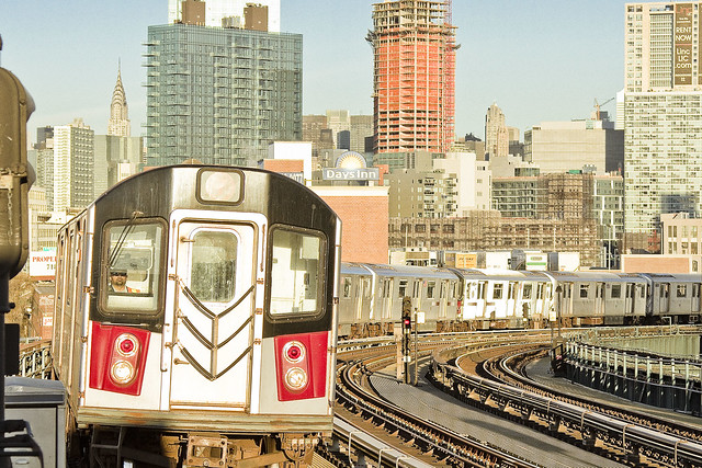
– photo by Mitch Waxman
On April 21st, 1917 – the original 11 stops of the IRT Subway line in Queens opened for business. We call the IRT Flushing line the 7, of course. The first stops on the line in Queens – Vernon/Jackson, Hunters Point Avenue, Court Square, and Queensboro were completed a couple of years earlier – but the stretch along Queens Blvd. and Roosevelt Avenue from 33rd Rawson to 103rd Corona Plaza is 99 years old today.
The NY Times was along for that first ride – leaving Grand Central at 3 p.m. and visiting the first 11 stations of the so called Corona Extension. Check out their reportage here.
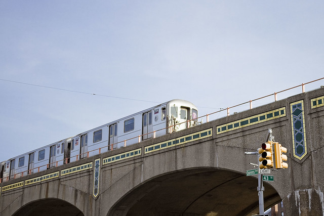
– photo by Mitch Waxman
The original names for these IRT Flushing line stops were Rawson street (33rd), Lowery street (40th), Bliss street (46th), Lincoln street (52nd), Flake street (61st), Fiske Avenue (69th), Broadway (74th), 25th avenue (82nd), Elmhurst avenue, Junction Blvd., and Alburtis avenue (103 Corona Plaza). Willets Point came online in May of 1917, and Main Street in Flushing would open in February of 1928.
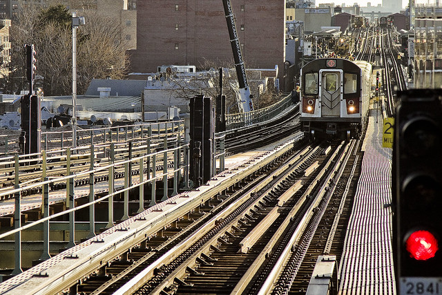
– photo by Mitch Waxman
I actually spent my afternoon yesterday visiting and photographing all of these locations, but was unable to deliver the finished product in time for the anniversary this year, so archive shots of the 7 – some of which have been presented before – are here in their stead.
The historical development of western Queens from a community of farmers and dairymen to the bustling and crowded community of modernity is tied back to several watershed moments in the early 20th century. The opening of Queensboro in 1909, Sunnyside Yards in 1910, and the Steinway subway tunnels opening for business in 1907.
“follow” me on Twitter- @newtownpentacle
Walking Tour – Saturday, April 23rd, 2016 –
First Calvary Cemetery Walk.
Join Newtown Creek Alliance historian Mitch Waxman at First Calvary Cemetery, found in LIC’s Blissville neighborhood along Newtown Creek. Attendance limited to 15 people.
Click here for more info and ticketing.
forgotten nether
Saturday – Calvary Cemetery awaits.

– photo by Mitch Waxman
At 12 p.m. on this coming Saturday, I’ll be narrating (humbly) a walking tour of First Calvary Cemetery here in LIC’s Blissville neighborhood. I will be at the northeast corner of Greenpoint and Review Avenues at 11:30 a.m. As long time readers of this, your Newtown Pentacle, will tell you – I have a special love for Calvary.
It’s the largest chunk of “green infrastructure” found along the Newtown Creek as well as serving as the final resting place of literally millions of Roman Catholic New Yorkers. It’s part of the firmament of LIC, and a significant touchstone for the history of 19th century NYC.

– photo by Mitch Waxman
Expect to encounter unexpected life forms in Calvary. The cemetery lies along the migration routes of several bird species, and I’ve spotted everything from Canada Geese to Great Blue Herons and Red Tail Hawks there. On, and in, the ground there’s a plethora of critters – such as the small rabbits which the Irish of the 19th century would have referred to as “Coney’s.” No guarantee on what we will spot, but there’ll be something interesting.

– photo by Mitch Waxman
Sculptural monuments are found everywhere in First Calvary, from thirty foot high obelisks to enormous mausolea. We will be visiting the final resting place of Governors, Senators, even the tomb of the original gangster himself – Joseph Masseria. The rightful King of Ireland is buried in Calvary, along with members of Corcoran’s Legion – the Fighting 69th. For NYC history fans, and tapophiles – this place is a smorgasbord of interest.

– photo by Mitch Waxman
The walking tour will be roughly two hours long, and will range over several shallow hills which host a natural grass surface. A hat or parasol is highly recommended to shield yourself from the sun. The walk is not difficult, but if you suffer from mobility issues – this likely is not the tour for you. Surrounding Calvary Cemetery are the concrete devastations of Western Queens – and the heavy industrial zone which forms the northern shoreline of the Newtown Creek. We will have a unrivaled view of the ongoing Kosciuszko Bridge construction project, btw.

– photo by Mitch Waxman
Bring your camera along, as Calvary Cemetery is a jewel. The Manhattan skyline is omnipresent, providing for impossibly candid views of an area stretching from the Williamsburg Bridge to the Queensboro. During the era of the so called “Gangs of New York” there was a saying which went “All roads lead to Calvary” and the cemetery was once a major destination for the Catholic masses of tenement Manhattan. Surrounding the great burying ground were saloons and road houses that serviced mourners. After the tour concludes, we will be visiting the last of these road houses (bar and food not included in ticket price, btw, just a post tour hang out).
One other thing to mention, obviously, is that if there’s a funeral underway we are going to steer clear of it out of respect and deference for the mourners.

– photo by Mitch Waxman
Walk ups are always welcome, for those of you uncomfortable with online ticketing, and the cost of the tour is $25 per head. For those of you who are comfortable with such online things, the link found below will take you to a credit card processing page. As a note, I couldn’t make the “ships within two weeks” line go away on the cc processing page, which a couple of people mentioned as being confusing. Nothing will be shipped to you, but you will receive an email receipt and your name will appear on the “check in” list I’ll be using “day of.”
Hope to see you Saturday morning, at the corner of Greenpoint and Review Avenue, at 12 p.m.
“follow” me on Twitter- @newtownpentacle
Walking Tour – Saturday, April 23rd, 2016 –
First Calvary Cemetery Walk.
Join Newtown Creek Alliance historian Mitch Waxman at First Calvary Cemetery, found in LIC’s Blissville neighborhood along Newtown Creek. Attendance limited to 15 people.
Click here for more info and ticketing.
unpleasant person
No matter where I go, there I am.

– photo by Mitch Waxman
One has been particularly verbose and vitriolic this week about subjects substantial, which indicates to those who know me that the proverbial process best described in “Brooklynese” as “gettin my shits togetha” has been underway for the last several weeks. The walking tours season has begun, and I’m planning a series of excursions for the year with Mai Armstrong and the various organizations we work with. Cross your fingers and thank the stars – as boat trips, walking tours, and all kinds of cool stuff are being planned. The Atlas Obscura tour listed below has already sold out, I’m afraid, but I’ve got a few pretty cool irons in the fire right now.
While we’re waiting to finalize things, Mai and I decided we might do a walk through Calvary Cemetery with a smaller than usual group, next weekend – probably Saturday. More on this one Monday, and I’ll have a link ready for those of you who might want to come along.

– photo by Mitch Waxman
There’s a few iconic Queens spots which will be hitting centennial anniversaries pretty soon, and I’m trying to figure out a few ways to commemorate that. Again, these things are on the stove’s back burners and simmering right now. A bizarre part of my thought processes, one which always befuddled and confused those unlucky enough to know me, is that I can take a project and tuck it away in my subconscious for processing while my waking mind concentrates on and handles other stuff like walking and laundry. Sometimes these simmering bits are utterly forgotten until I look through one of my notebooks and then – boom – it boils over and unfolds into something conscious and actionable.
Unfortunately, this “unfolding” often happens at 2:30 in the morning, which finds me huddled over the computer scratching away at a project as the sun is coming up. Lack of sleep is why my eyes often look and feel like they’ve been boiled.

– photo by Mitch Waxman
Photography wise, there’s a few new locations and opportunities I’m interested in pursuing this summer, and many ongoing spots that I need to exert some real effort into continuing to document. Within the next two weeks, one plans to roam through the predominance of the municipality of Long Island City’s former borders, and do so with camera in hand. There’s night shots I want, places I’ve never been that I intend on visiting, and nothing – NOTHING – is going to stop me from getting to Aquarium in Coney Island this year. I’ve got boats to catch, trains to find…
It should all be a lot of fun, but it’s all still kind of depressing at the same time.
“follow” me on Twitter- @newtownpentacle
April 16th, Obscura Day 2016 –
“Creek to Creek Industrial Greenpoint Walking Tour” with Mitch Waxman and Geoff Cobb.
Join Newtown Creek Alliance historian Mitch Waxman and Greenpoint historian and author Geoff Cobb for a three-hour exploration of the coastline of Greenpoint. Click here for more info and ticketing.
repellant mannerisms
No more meetings, supposition instead, in today’s post.

– photo by Mitch Waxman
The last few days, you’ve been informed about my various causes and committees, and some of the “inside baseball” on the Newtown Creek story has been offered. There’s more I could tell you, and will in the fullness of time. I’ve got a whole world of weird minglings with the “powers that be” which I can relate, but a lot of these encounters are in situations where some discretion is expected from all parties and I don’t want to act like a jerk and tattle everything I’ve been told about this and that.
One thing which I’ve been annoying the powerful about is the Mayor’s proposed street car system – the BQX. When I bring it up, the powers and potentates of the permanent government exhibit a momentary flash of wild panic, and they then start assuring me that it’s an entirely reasonable proposal, all the while forcing that horrible crocodile grin of the professional politician across their mugs.

– photo by Mitch Waxman
I’ve got the route of this BQX thing figured out, incidentally. It’s an Einsteinian thought experiment, this, and entirely out of my own brain – none of the officials I know will say anything other than “we’re looking at a number of options” even in informal settings. My impression is that the Mayor just dropped this on officialdom and didn’t really check with anyone to see if the BQX was feasible before announcing it, but that’s strictly an impression. The route I list below is based on my personal knowledge gained from thousands of hours walking the western shore of Long Island, coupled with literally hundreds of water born observations.
At the northern side – it’ll start at the former Politti Power Plant by Astoria Park, travel down Shore Road to the corner of Astoria Park South, and then ride on a causeway built into the water, on its way to the Astoria Point development. It’ll roll around the periphery of the peninsula which Astoria Point will share with NYCHA’s Astoria Houses and then come back to shore at Hallets Cove near Socrates Sculpture Garden. It then heads south along Vernon to LIC, turning west at 46th avenue to meet and make a left on Center Blvd. just after Anable Basin. From there, it continues down to second street and a new drawbridge over Newtown Creek, which meets up with West Street in Greenpoint. South along West to Kent and Williamsburg, then around Wallabout Creek to Kent’s intersection with Flushing Avenue. The BQX then tracks south down Flushing Avenue and around the Navy Yard.
I’ll get to Vinegar Hill and DUMBO in a minute.
Let’s just skip ahead to Brooklyn Bridge Park, where Furman Street would carry BQX south to Columbia and then it would track under the Gowanus Expressway through Red Hook and all the way to Industry City in Sunset Park. I think it would be passing over a retrofitted Hamilton Avenue Bridge spanning over the Gowanus Canal.
Hamilton carries the BQX trackway to Third Avenue and – VOILA – you’re at Industry City.

– photo by Mitch Waxman
The fly in the BQX ointment, as I see it, is precisely that Vinegar Hill section and the area which my dad used to refer to as “Downtown Brooklyn” where the Manhattan and Brooklyn bridges converge with Subway lines, highways, a complex of courts, housing projects, government buildings, the rich people in Brooklyn Heights who are easily annoyed and politically relevant, and – literally – the highest real estate valuations which can be found upon the planet along Brooklyn’s Gold Coast.
I have no idea how you’d thread the streetcar needle through that area, and most of the important people (whom you’d be surprised I even know, let alone enjoy congenial relationships with – I still can’t believe some of the folks I get to interact with) I’ve asked how no idea how to do it either. I’ve been told by engineer friends in the construction business that it would be easier to build the two new bridges over Newtown Creek and the Gowanus Canal for this project, simultaneously, than it will be to acquire or afford enough space in “Downtown Brooklyn” for the BQX.
It’s funny, I have no real opinion on this project. I’m neither for, nor against, as I explain to these members of the permanent government whom I condemn to this conversation. I just think it’s kind of an interesting thought experiment, and when the conversation runs its course – alternatively suggest select bus service which could use the route described above, and you wouldn’t have to build any new bridges or buy up parts of DUMBO to accomplish the goal of the thing and achieve a right of way.
“follow” me on Twitter- @newtownpentacle
April 16th, Obscura Day 2016 –
“Creek to Creek Industrial Greenpoint Walking Tour” with Mitch Waxman and Geoff Cobb.
Join Newtown Creek Alliance historian Mitch Waxman and Greenpoint historian and author Geoff Cobb for a three-hour exploration of the coastline of Greenpoint. Click here for more info and ticketing.
