Posts Tagged ‘Gowanus Canal’
open portal
The Third Street Bridge over the Gowanus Canal, and some demolition type action, in today’s post.

– photo by Mitch Waxman
Unlike the other Gowanus Bridges which have been featured this last week, there’s only one shot of the Third Street span in today’s post. I got these whilst standing in the Whole Foods Supermarket parking lot, one misty day, and unfortunately for the bridge -I was a bit distracted by a whole other show that was being performed on the far bank.
from nyc.gov
The Third Street Bridge is a double-leaf Scherzer rolling lift bascule, supporting Third Street over the Gowanus Canal in the Borough of Brooklyn. It supports two vehicular traffic lanes, each approximately 16 feet wide, and two sidewalks, each six feet wide.
Initially constructed around 1905, the bridge was comprehensively rehabilitated in 1986. This included new mechanical and electrical equipment, and a partial structural rehabilitation.

– photo by Mitch Waxman
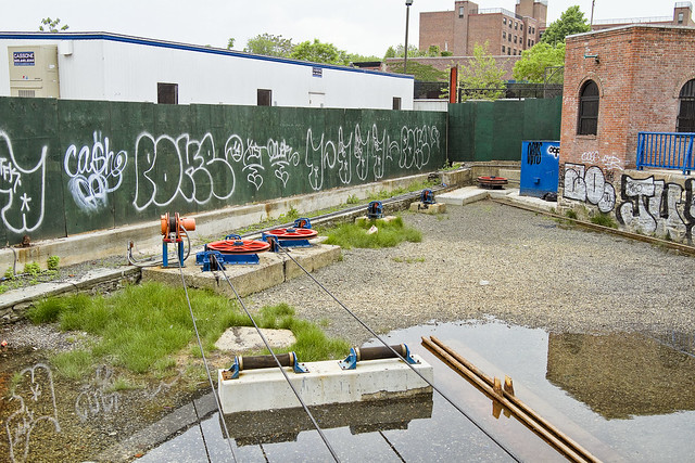
The former Burns Brothers Coal pockets, an iconic feature for area natives, were in the process of being carelessly demolished. I say careless based on both the amount of material which was splashing into the water and the utter lack of dust mitigation. The latter is curable by setting up a hose and lawn sprinkler, but that might add a few bucks onto the contractors bill, so… “Pardonmeforasking” did a great post which includes shots of the former industrial site, when it was still there, which is linked to below.
from pardonmeforasking.blogspot.com
Barely days after the demolition of the iconic silos at Carroll Street on the shores of the Gowanus Canal, comes news that the Burns Brothers coal pockets are in the process of being torn down. The photo above was taken yesterday by my friend Eymund Diegel. By today, Friday, the concrete silos opposite Whole Foods at 6th Street between 2nd and 3rd Avenue will be history.

– photo by Mitch Waxman
Regardless of the sloppy manner, the work being performed was quite dramatic. Whole Foods customers were actually dismounting their bicycles, if you can believe such a thing. They stopped, used their phones to record the process, shook their heads and remounted their bikes. Most rode away in the direction of Park Slope, on the sidewalk, eschewing the use of the bike lanes. The impression I gathered was that the majority had to attempt to complete other high minded and or self satisfying chores, after accomplishing their grocery shopping.
from 6tocelebrate.org
Coal pockets were used to move and store the coal from barges on the canal to wagons and, later, trucks for delivery. The eight pockets closest to the water were built be- tween 1915 and 1924, and by 1938 there were 10 more. These 40- and 50-foot tall structures are no longer used today but remain as relics of the canal’s crucial transportation role.
“follow” me on Twitter- @newtownpentacle
There’s a Newtown Creek walking tour, and a Magic Lantern show, coming up.
Saturday, June 7th, 13 Steps around Dutch Kills with Atlas Obscura.
Click here for tickets and more info.
Wednesday, June 11th, Newtown Creek Magic Lantern Show with Brooklyn Brainery.
Click here for tickets and more info.
out into
The Ninth Street Bridge, over the Gowanus Canal, in today’s post.

– photo by Mitch Waxman
Yesterday, the Hamilton Avenue drawbridge which provides entry to and from the Gowanus Canal in Brooklyn was described. Last Sunday, a humble narrator found his way on to an Open House NY boat trip to the troubled waterway, which penetrated as far back as the Fifth Street Basin.
from nyc.gov
This lift bridge replaced a bascule span that was in an advanced state of deterioration. The current structure provides an improved wider channel in the canal for unobstructed vessel passage. The bridge has state-of-the-art, electronically-controlled lifting machinery that should provide 50 years of reliable service. The bridge carries 3 lanes of traffic; 2 lanes westbound and 1 eastbound.

– photo by Mitch Waxman
Special attention was paid to the opening and closing of the two drawbridges encountered. There are five movable bridges over the Gowanus, as well as two static ones.
There’s actually two bridges in these shots, as the Ninth Street Bridge is overflown by the Smith 9th Street Subway station viaduct.
from wikipedia
The opaqueness of the Gowanus water obstructs sunlight to one third of the six feet needed for aquatic plant growth. Rising gas bubbles betray the decomposition of sewage sludge that on a warm, sultry day produces the canal’s notable ripe stench. The murky depths of the canal conceal the remnants of its industrial past: cement, oil, mercury, lead, multiple volatile organic compounds,[10] PCBs, coal tar, and other contaminants. A 2007 Science Line report found gonorrhea and unidentified organisms in the canal. In 1951, with the opening of the elevated Gowanus Expressway over the waterway, easy access for trucks and cars catalyzed industry slightly, but with 150,000 vehicles passing overhead each day, the expressway also deposits tons of toxic emissions into the air and water beneath.

– photo by Mitch Waxman
The Ninth Street span is a lift bridge, which replaced a failing drawbridge that occupied this spot for decades. The construction of all this gear was pretty recent.
from schiavoneconstruction.com
Reconstruction included demolition, removal and disposal of existing rolling leaf bascule bridge superstructure, machinery and controls, piers and abutments. Construction of new lift bridge included superstructure, machinery, control house, fender system, piers and abutments. Twenty stepped diameter caissons were installed to rock depths of up to 180 feet. All work had to be performed beneath existing NYCT elevated structure requiring temporary support of existing columns.

– photo by Mitch Waxman
It was pretty exciting seeing the roadway just take off and start rising. The operation was nowhere near as noisy as I would have thought, but then again, I was on an idling ferry boat and the sounds of the nearby Gowanus Expressway really travel across this former floodplain.
from epa.gov
There are five east–west bridge crossings over the canal, at Union Street, Carroll Street, Third Street, Ninth Street, and Hamilton Avenue. The Gowanus Expressway and the Culver Line of the New York City Subway pass overhead. The canal is located in a mixed residential-commercial-industrial area, and it borders several residential neighborhoods, including Gowanus, Park Slope, Cobble Hill, Carroll Gardens, and Red Hook. The waterfront properties abutting the canal are primarily commercial and industrial.
Environmental sampling performed before this RI revealed that the sediments throughout the Gowanus Canal are contaminated with a variety of pollutants, including polycyclic aromatic hydrocarbons (PAHs), polychlorinated biphenyls (PCBs), volatile organic compounds (VOCs), and heavy metals (USACE, 2004, 2006; GEI, 2007). No environmental remediation activities have been performed to date.

– photo by Mitch Waxman
Self confessed and avowed as an infrastructure freak, seeing the cable mechanisms climbing the towers was actually kind of thrilling. This is the sort of thing you normally observe from the landward side.
from wikipedia
A vertical-lift bridge or lift bridge is a type of movable bridge in which a span rises vertically while remaining parallel with the deck.
The vertical lift offers several benefits over other movable bridges such as the bascule and swing-span bridge. Generally speaking they cost less to build for longer moveable spans. The counterweights in a vertical lift are only required to be equal to the weight of the deck, whereas bascule bridge counterweights must weigh several times as much as the span being lifted. As a result, heavier materials can be used in the deck, and so this type of bridge is especially suited for heavy railroad use.

– photo by Mitch Waxman
Brooklyn kid that I once was, one has imagined it would be great fun to ride the roadway of one of these lift bridges as it ascended. Turns out that would be foolhardy in the extreme, as the actual tonnages and pressures being levered around are positively cyclopean and could easily squish a man flat.
Last year, in East Boston, one of these lift bridges actually ate somebody.
from nydailynews.com
Police say the woman was crossing the Meridian Street Bridge, which spans East Boston and Chelsea, at about 12:21 p.m. Tuesday. As she started across, the lift operator opened the bridge so a boat could pass beneath the span, the Boston Globe reported.
The movement jolted the unidentified woman off her feet, leaving her hanging from one open end of the bridge, cops say. The woman began screaming for help and the operator, cops say, closed the span in response. Instead of helping, the woman was crushed to death between the massive steel plates.

– photo by Mitch Waxman
For some reason, the NYC DOT is rather vague about certain things.
Once upon a time, they’d brag to anybody that would listen about how many thousands of times a drawbridge opened or closed, citing the smooth exchange of maritime and vehicular traffic streams as a proof of public monies being well invested. These days, they proudly proclaim automotive traffic numbers, as in this 2010 report which describes the Ninth Street Lift Bridge as having allowed some 13,362 toll free automotive crossings.

– photo by Mitch Waxman
May of 1910 saw a true conflagration right around here. A 4 alarm fire erupted at the Cranford Company, immolating oil and gasoline tanks, which drew the attentions of both terrestrial and maritime firefighter. Check out the NY Times piece below for all the sordid details. The losses are described as $150,000, which would be around $3,695,387.30 today.
from at nytimes.com
Firemen from engine companies responding to four alarms and the members of three fireboat companies last night fought a blaze which completely destroyed the building of the Cranford Company, contractors in asphalt and tar work, at Ninth Street and the Gowanus Canal, Brooklyn.

– photo by Mitch Waxman
As far as I’ve been able to dope out, the spot that this Ninth Street Bridge occupies is in the vicinity of where the colonial era “Cole’s Mill” was located. A mill and mill pond supposedly built by John Rapelye and an army of slaves out of the aboriginal marshlands, it then came into the possession of a fellow named Jordan Cole – hence “Cole’s Mill.”

– photo by Mitch Waxman
More recently, roughly a century ago, we’d be enjoying a nice view of the Tartar Chemical Company’s works.
Tartar is something that most modern people would associate with a sauce used on fried fish, but it was one of the wonder chemicals of the 19th century. Essentially, the Tartar Chemical works were an acid factory.
from 1909’s “Contributions From The Sanitary Research Laboratory And Sewage Experiment Station,” courtesy google books
The upper part of the canal is badly polluted by sewage. At the lower end the pollution is largely industrial wastes mixed with more or less sewage.
As a rule the amount of nitrogen present varies directly with the amount of sewage. The other constituents of sewage vary with the nitrogen. Therefore when the nitrogen is greatly increased without a corresponding increase in the other sewage substances it is an indication of industrial wastes. This is exactly what happens in that portion of the canal opposite the Tartar Chemical Company. On talking with one of their employees, we learned that crude argol is digested with sulphuric acid, and that the waste product is an acid sludge running high in sulphates and nitrogen.
In the first series below, Ninth Street the oxygen consumed curve went up rapidly. In the second series the curve had a downward tendency. The starch factory, not running on Sunday, had no waste to discharge at that time. The abnormal values for the oxygen consumed are probably due to gluten in the wastes discharged by the starch factory.

– photo by Mitch Waxman
Three out of five down. Guess that we’re heading over to Third Street, on foot this time, in tomorrow’s post.
from wikipedia
Tartaric acid and its derivatives have a plethora of uses in the field of pharmaceuticals. For example, tartaric acid has been used in the production of effervescent salts, in combination with citric acid, in order to improve the taste of oral medications. The potassium antimonyl derivative of the acid known as tartar emetic is included, in small doses, in cough syrup as an expectorant.
Tartaric acid also has several applications for industrial use. The acid has been observed to chelate metal ions such as calcium and magnesium. Therefore, the acid has served in the farming and metal industries as a chelating agent for complexing micronutrients in soil fertilizer and for cleaning metal surfaces consisting of aluminum, copper, iron, and alloys of these metals, respectively.
“follow” me on Twitter- @newtownpentacle
There’s a Newtown Creek walking tour, and a Magic Lantern show, coming up.
Saturday, June 7th, 13 Steps around Dutch Kills with Atlas Obscura.
Click here for tickets and more info.
Wednesday, June 11th, Newtown Creek Magic Lantern Show with Brooklyn Brainery.
Click here for tickets and more info.
on toward
The Hamilton Avenue Bridge, in today’s post.

– photo by Mitch Waxman
“The truth of our times, as told in graphic narrative” requires a lot of “boots on the ground” time.
To wit, last weekend, a rare Sunday afternoon with no obligations presented a humble narrator with an opportunity to visit the hellish expanses of the Gowanus Canal onboard a tour boat chartered by the Open House NY group.
from nyc.gov
The Hamilton Avenue Bridge is a bascule bridge with two parallel leafs, one carrying the northbound roadway and the other carrying the southbound roadway. Most of the length of Hamilton Avenue runs below the elevated portion of the Gowanus Expressway, including the bridge. The bridge connects Smith Street and Second Avenue over the Gowanus Canal and is the first canal crossing north of the Gowanus Bay.

– photo by Mitch Waxman
The tour utilized a NY Waterways Ferry, leaving from Manhattan’s World Financial Center Ferry Terminal on the Hudson River, nearby Vesey Street. After transiting through Gowanus Bay, which is a whole other story, the vessel arrived at the somewhat unique Hamilton Avenue Bridge – a skew bascule type drawbridge.
a fascinating discussion of this “knee-girder bascule bridge,” and its recent reconstruction, by the actual engineers that performed the rehabilitation, can be found at heavymovablestructures.org
The rarely seen Hanover skew bascule, also known as a knee-girder bascule bridge is a unique and complex movable structure in terms of both design and construction. The replacement of a movable bridge during an accelerated construction period is also an incredibly difficult task to engineer and construct. Either one of these constraints would make a project difficult to execute. For the Hamilton Avenue Bridge project in New York City, however, these two levels of complexity combined to create a one-of-a-kind project that would challenge the owner, designers and constructor to achieve a near impossible goal: to replace a skewed bascule bridge with a new, fully operational span in sixty-four days.

– photo by Mitch Waxman
The bridge’s horns sounded, and its traffic gates were deployed, and employees of the NYC DOT thereupon activated the electrical systems that drew the roadway up and away from its piers. An obtuse angle was achieved, relative to the waters level, which opened an aperture and allowed navigation.
from 1863, ay nytimes.com
THE RAILROAD ACCIDENT AT HAMILTON-AVENUE BRIDGE — CONCLUSION OF THE CORONER’s INVESTIGATION, AND VERDICT OF THE JURY. — The investigation relating to the circumstances connected with the deplorable accident on Wednesday night, upon which occasion car No. 119 of the Greenwood and Fulton Ferry line was precipitated into Gowanus Creek, in consequence of the opening of the draw of Hamilton-avenue Bridge, was concluded before Coroner BENNETT and a jury, yesterday afternoon.

– photo by Mitch Waxman
In the distance, the Smith 9th street elevated Subway station and the Ninth Street lift bridge glitter.
from 1892’s United States Congressional serial set, Issue 2914, courtesy google books

– photo by Mitch Waxman
SuperfunD. That’s how people refer to both Gowanus Canal and my beloved Newtown Creek. That’s superfun with a capital D following it. The more you learn about these places, however, the less fun they are.
from epa.gov
The Gowanus Canal is a 100-foot wide,1.8-mile long canal located in the New York City borough of Brooklyn, Kings County, New York. Connected to Gowanus Bay in Upper New York Bay, the canal borders several residential neighborhoods including Gowanus, Park Slope, Cobble Hill, Carroll Gardens, and Red Hook. The adjacent waterfront is primarily commercial and industrial, currently consisting of concrete plants, warehouses, and parking lots. There are five east-west bridge crossings over the canal, located at Union Street, Carroll Street, Third Street, Ninth Street, and Hamilton Avenue. The Gowanus Expressway and the IND Culver Line of the New York City Subway, an aboveground section of the original Independent Subway System, pass overhead.

– photo by Mitch Waxman
A winter time shot of the bridge’s roadway, which is overflown by the hurtling viridian of the Gowanus Expressway, high overhead. I’m told it’s close to a 300 feet drop from top to bottom.
from nycroads.com
Beginning in 1939, Robert Moses oversaw construction of the Gowanus Parkway, an elevated highway placed on top of the pillars of the old 3rd Avenue BMT Elevated Line through the Sunset Park and Gowanus sections of Brooklyn. It would eventually become part of a limited-access parkway loop encircling four of the five boroughs. Since the Gowanus Parkway was to be constructed atop a pre-existing elevated facility, Moses had little trouble getting his project approved by the New York City Council.
However, the Gowanus Parkway would require more land for a wide roadway and entrance-exit ramps. This required the demolition of many homes and businesses along Third Avenue, a tightly knit block of Northern and Western European immigrants. In his 1974 biography The Power Broker, Robert A. Caro argued that Moses’ highway created a “Chinese wall” that accelerated the process of deterioration that began two blocks west, along the waterfront terminals. He also points out that residents fought to have the highway placed closer to the waterfront to protect the neighborhood.

– photo by Mitch Waxman
Another wintertime shot, this one from the Ninth Street Bridge looking back at the entrance – the front door, if you would – of the Gowanus Canal.
from nyc.gov
The construction of the Canal began in 1849 and was accomplished by deepening and widening the Gowanus Creek and creating bulkheads along the waterfront. The Canal was fully built out by 1869.
Even before it was complete, the Canal was attracting foundries, shipyards, gas manufacturing plants, coal yards and paint and ink factories to the waterfront and adjacent lots. By 1870, the surrounding area, with its natural marshlands and freshwater streams, had been fully urbanized and industrialized.

– photo by Mitch Waxman
Back to last Sunday, and the approach to the Hamilton Avenue Bridge on the NY Waterways Ferry’s return trip. The closest analogy I can use to describe the Gowanus experience, for those of us who live along the currently undefended border of Brooklyn and Queens, is visiting one of the tributaries of Newtown Creek – specifically Dutch Kills. (tour this weekend! scroll down for details)
also from nyc.gov
The Canal was the one of the prime catalysts in shaping the industrial nature of the area, as foundries, gas manufacturing plants, coal yards, paint and ink factories and other businesses flocked to the waterfront and adjacent lots.

– photo by Mitch Waxman
We’ve got the LIE on Dutch Kills, multiple drawbridges, and a similar historical tale.
Both waterways began the industrial age as the home of tidal mill ponds, but Dutch Kills was spared a lot of the early and quite dirty industries which called the Gowanus home as early as the 1860’s. What happened to Dutch Kills largely occurred in the late 19th and especially early 20th centuries (the bad stuff was happening further up the Creek in those days, in Blissville, along English Kills, and especially on Furmans Island).
from riverkeeper.org
After almost 150 years of industrial use and decades of raw sewage discharges from New York City’s sewers, the Gowanus Canal has become one of the nation’s most contaminated bodies of water. The putrid sediments at the bottom of the canal contain PCBs, heavy metals, pesticides, volatile organic compounds, sewage solids and coal tar wastes. Adding to this toxic legacy, the manufactured gas plants (MGP), cement factories, oil refineries, tanneries, chemical plants and other industries that have called the canal home also have left behind underground plumes of pollution and contaminated the land and the groundwater, which continues to leach toxins into the canal.

– photo by Mitch Waxman
That’s the Hamilton Avenue Bridge, gateway to the notorious Gowanus Canal, lords and ladies.
from wikisource.org
That same June evening, without having heard a word from the sea, Malone was desperately busy among the alleys of Red Hook. A sudden stir seemed to permeate the place, and as if apprised by ‘grapevine telegraph’ of something singular, the denizens clustered expectantly around the dance-hall church and the houses in Parker Place. Three children had just disappeared—blue-eyed Norwegians from the streets toward Gowanus—and there were rumours of a mob forming among the sturdy Vikings of that section.
“follow” me on Twitter- @newtownpentacle
There’s a Newtown Creek walking tour, and a Magic Lantern show, coming up.
Saturday, June 7th, 13 Steps around Dutch Kills with Atlas Obscura.
Click here for tickets and more info.
Wednesday, June 11th, Newtown Creek Magic Lantern Show with Brooklyn Brainery.
Click here for tickets and more info.
old native
The Carroll Street Bridge, in today’s post.

– photo by Mitch Waxman
I’ve said it so many times on the Newtown Creek “Dutch Kills” tours that I’ve conducted – “The Borden Street Bridge is one of just two retractable bridges in NYC, the other is on Carroll Street over the Gowanus.” Then I go on to talk about Chicago and what a retractable bridge does and why its special, but it occurred to me that I’ve never done a post on the Carroll Street span. Today, the remedy.
Also, just as a note, I’ll be repeating the above quotation on this coming Saturday’s tour, see the link at the bottom of this post for details.
from nyc.gov
The Carroll Street Bridge is a retractile bridge crossing the Gowanus Canal in Brooklyn. The bridge, which was opened to traffic in 1889, supports a 17 foot wide roadway and two 4.5 foot sidewalks.

– photo by Mitch Waxman
What’s super cool about the Carroll Street span is the wooden road surfacing that allows vehicular egress over this section of the Gowanus Canal. There’s still one more bridge before the Gowanus reaches its inevitable conclusion, Union Street Bridge, but Carroll is where the industrial canal seems to shallow out and is one of the places where its entire “raison d’être” seems to have been forgotten.
from wikipedia
Retractable bridges date back to medieval times. Due to the large dedicated area required for this type of bridge, this design is not common. A retractable design may be considered when the maximum horizontal clearance is required (for example over a canal).
Two remaining examples exist in New York City (the Carroll Street Bridge (built 1889) in Brooklyn and the Borden Avenue Bridge in Queens).
– photo by Mitch Waxman
Pictured above are the pulleys and gears which provide locomotive force to the structure, and the aperture into which the roadway actually retracts to allow theoretical maritime egress. The Gowanus Dredgers boat club is nearby, and I suspect that they can tell you everything you’d want to know about the mores and habits exhibited by the NYC DOT engineers who care for and maintain the structure. Business has called me to South Brooklyn all year, and one of the more interesting “Gowanus People” I’ve met is a fellow named Joseph Alexiou, who provides a satisfying historical narrative for the Gowanus.
from tedxgowanus.com
A journalist and history buff, Joseph Alexiou is writing a book about the Gowanus Canal. He is the author of Paris for Dummies and contributing author to Frommer’s Paris 2012 and has written for New York, the New York Press, New York Observer, Gothamist and Paper Magazine. He is a former associate editor at Out magazine and has a master’s degree from the Graduate School of Journalism at Columbia University.

– photo by Mitch Waxman
Somebody else from the Gowanus crew that has impressed the heck out of me is Eymund Diegel. His knowledge of the Gowanus and its hydrology, history, and personality is staggering. Be forewarned and forearmed though, for if you seek his wisdom, bring a notepad or recording device with you – as the cascade of information he offers can be a bit overwhelming.
also from tedxgowanus.com
Eymund Diegel is the chair of Public Laboratory, a citizen science group partnered with the Gowanus Canal Conservancy’s Grassroots Aerial Photography program, where local citizen’s insights help improve Google Earth and City mapping of the neighborhood. As a Gowanus resident, he also helps out at the Hall of the Gowanus, a community historic research resource. Trained as an urban planner with a focus on watershed and environmental planning, he works with other local residents who have been tying digital cameras to kites and balloons to map and reconstruct the Gowanus Canal’s “ghost stream” network.
“follow” me on Twitter- @newtownpentacle
There’s a Newtown Creek walking tour, and a Magic Lantern show, coming up.
Saturday, June 7th, 13 Steps around Dutch Kills with Atlas Obscura.
Click here for tickets and more info.
Wednesday, June 11th, Newtown Creek Magic Lantern Show with Brooklyn Brainery.
Click here for tickets and more info.
constantly feeling
A walkabout in Red Hook, by the Gowanus.

– photo by Mitch Waxman
An assignment carried me out to the ancient harbor of South Brooklyn, Red Hook. After my business was concluded, a walkabout was conducted. Nothing “formal,” as I wasn’t looking for anything in particular, just poking around a bit while walking back to the train. Can’t have my beloved Creek think I’m cheating on her, especially not with her sister of the superfund.
– photo by Mitch Waxman
The Gowanus Canal, of which I know little. That’s something I say all the time, and I’m being a bit disingenuous. By the standards of the average person, I know a lot about Gowanus, but not enough to satisfactorily describe it. Recently, I attended a lecture by Joseph Alexiou, and that young man knows about the Gowanus.
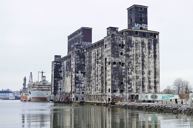
The structure pictured above was formerly a grain terminal, by the way.

– photo by Mitch Waxman
Unfortunately, much of the story here at Gowanus is the same as it is on Newtown Creek. Oil companies and chemical factories and manufactured gas plants and centuries of industrial activity, coupled with the City running open sewers directly into the water. Abandon all hope, ye huddled masses.
“follow” me on Twitter- @newtownpentacle


