Posts Tagged ‘Gowanus Canal’
nitrous vault
Friday

– photo by Mitch Waxman
A few final Friday photos from the far away Gowanus greet you this morning. The shot above looks towards the Union Street Bridge from the Carroll Street Bridge.
Uncharacteristically, I’m sort of at a loss of words today. Obvious reasons, read the news. It’s not like this wasn’t obviously going to happen sooner or later.

– photo by Mitch Waxman
That’s Carroll Street Bridge, which is one of only two retractile bridges in the entire City. The other is Borden Avenue Bridge, crossing the Dutch Kills tributary of Newtown Creek in Long Island City.
I cannot fathom the attempts on social media to rebrand the group of white supremacists who stormed the Capitol as “Antifa.” You broke it, you bought it. Assholes. When you lie down in the street with wild dogs, you get bit.

– photo by Mitch Waxman
On the way home, a quick stop was made to get the shot above, depicting three DSNY trucks on a ramp with the Gowanus Expressway in the background.
Good times, these.
Note: I’m writing this and several of the posts you’re going to see for the next week at the beginning of the week of Monday, January 4th. My plan is to continue doing my solo photo walks around LIC and the Newtown Creek in the dead of night as long as that’s feasible. If you continue to see regular updates here, that means everything is kosher as far as health and well being. If the blog stops updating, it means that things have gone badly for a humble narrator.
“follow” me on Twitter- @newtownpentacle
Buy a book!
“In the Shadows at Newtown Creek,” an 88 page softcover 8.5×11 magazine format photo book by Mitch Waxman, is now on sale at blurb.com for $30.
outrageous conclusions
Thursday

– photo by Mitch Waxman
A few more from the Gowanus Dredging operation today, and since the pursuance of getting these shots required no small amount of physical hardship for a humble narrator, we’re staying on the subject for a bit longer.
As mentioned earlier in the week, one woke up a couple of hours before sunrise in Astoria on the literal other side of a very Long Island, then suffered frigid middle December conditions on the East River to get here, and having dodged heavy trucks the entire morning on the streets of Red Hook and Sunset Park, the two eggs with ham and swiss on a roll which I had for breakfast had long ago burned away. It had also been multiple hours since I had drank anything, and the combination of fatigue and an empty fuel tank were beginning to set in. The diesel exhaust didn’t help.
I go to these places so you don’t have to, Lords and Ladies.

– photo by Mitch Waxman
The material being scooped out of the Gowanus Canal gets shipped elsewhere for processing. The Superfund people at EPA aren’t exactly forthcoming about where the material gets sent, but I’d venture a guess about that as being somewhere in New Jersey and likely not too far from Bayonne. I can offer a conjectured description about what happens to it afterwards, though.
First, excess moisture will be mechanically removed either by centrifuge or compression. The freed liquid is fed into a wastewater treatment process, one not dissimilar to what happens at a sewer plant. Pollutants and contaminants are filtered out, the water is cleaned up, and then released. The filtered contaminants are combined with the dewatered solids. Secondly, the solids are sterilized, dried, and combined with an inert material like concrete. The concrete is formed into blocks, the blocks get shipped off somewhere for disposal. That somewhere is likely a tapped out underground mine which will be sealed off once full of these now inert blocks.
When Newtown Creek’s process begins to manifest physically, it will look a lot like the shots in this week’s post, just on a grander scale.

– photo by Mitch Waxman
The shot above is included, one which I’m fairly sure is of the Third Street Bridge, as I’ve never seen this particular span open before. This didn’t seem to be part of the dredge operation, rather it looked like the NYC DOT (owners of the thing) were performing some sort of maintenance on the thing.
A bit more of this Southwest Brooklyn action tomorrow.
Note: I’m writing this and several of the posts you’re going to see for the next week at the beginning of the week of Monday, January 4th. My plan is to continue doing my solo photo walks around LIC and the Newtown Creek in the dead of night as long as that’s feasible. If you continue to see regular updates here, that means everything is kosher as far as health and well being. If the blog stops updating, it means that things have gone badly for a humble narrator.
“follow” me on Twitter- @newtownpentacle
Buy a book!
“In the Shadows at Newtown Creek,” an 88 page softcover 8.5×11 magazine format photo book by Mitch Waxman, is now on sale at blurb.com for $30.
beckoning vistas
Wednesday

– photo by Mitch Waxman
It took leaving HQ in Astoria at 5:30 in the morning, freezing my falafels off on a ferry in middle December, and then walking about a mile and a half but I managed to get to the Gowanus Canal while superfund dredging was actually happening. Pictured above is the Gowanus, as seen from the Hamilton Avenue Bridge under the Gowanus Expressway. Normal circumstance, if such a thing exists anymore, would have found me taking the G train to the elevated structure at the top of the shot – which is the Smith/9th street station. The draw bridge it overflies is the 9th street Bridge. The bucket barge and fuel barge/tug at lower left aren’t part of the dredge operations, as a note, they were there for other business.

– photo by Mitch Waxman
Named to the Federal Environmental Protection Agency’s CERCLA or “Superfund” list at the same time as my beloved Newtown Creek, Gowanus Canal involves a significantly smaller geographical and simpler pollution problem to solve than Newtown Creek does. The Gowanus Canal is analogous in terms of scale and circumstance to the Long Island City tributary of Newtown Creek called Dutch Kills, in fact. Since the problem is smaller and somewhat simpler, Gowanus got to this part of the process first, whereas Newtown Creek is still several years away from dredging. Saying that, it’s a real mess down there at Gowanus, under the water.
Before you ask – it really didn’t smell that bad. The most miserable thing, odor wise, was experiencing the exhaust pouring out of the stacks of the Tugs and other equipment as they performed their tasks. You’d suddenly find yourself standing in a pall of blue diesel exhaust when the wind bent in your direction.

– photo by Mitch Waxman
There were distinct units working on the various “locks” created by the street bridges crossing the Gowanus. Pictured above is the operation that was stationed between the 9th street and Union Street Bridges. Gowanus Bay narrows into the canal, and it’s crossed by seven bridges; Union Street, Carroll Street, Third Street, the New York City Subway’s Culver Viaduct (Smith 9th street station), Ninth Street, Hamilton Avenue, and the Gowanus Expressway.

– photo by Mitch Waxman
Dredging is something I usually see all the time, but I spend a lot of time on the water under normal circumstance. Maintenance of shipping channels in deeper water usually entails using a specialized rig with it’s own power plant that has steel “pods” which are lowered into the water and act as legs to stabilize the machine. What I saw at Gowanus were “materials handlers” with specialized grabbers on them, as pictured above.
The sediments are scooped off the bottom, the water is drained into one bucket barge, and then the solids go into another. It’s likely that the more liquid material will be decanted and then processed as wastewater or sewage would be.

– photo by Mitch Waxman
That’s the Hamilton Avenue lift bridge raising to allow a tug towing away one of those “solids” barges out of the canal. It’s called a lift bridge as the entire roadway lifts vertically to allow maritime egress.
As always – it doesn’t matter if the Tug is pushing, or pulling, or the barge is tied up “on the hip” it’s called “towing.”

– photo by Mitch Waxman
Same Tug, different bridge. This is the Hamilton Avenue Bridge, which you saw in the first shot from the other side. It’s a double bascule draw bridge, but the two movable sections are parallel to each other. A more traditional setup for this sort of structure would be the Pulaski Bridge at Newtown Creek, where the two bascules are in line with each other and form an arch when closed.
More tomorrow.
Note: I’m writing this and several of the posts you’re going to see for the next week at the beginning of the week of Monday, January 4th. My plan is to continue doing my solo photo walks around LIC and the Newtown Creek in the dead of night as long as that’s feasible. If you continue to see regular updates here, that means everything is kosher as far as health and well being. If the blog stops updating, it means that things have gone badly for a humble narrator.
“follow” me on Twitter- @newtownpentacle
Buy a book!
“In the Shadows at Newtown Creek,” an 88 page softcover 8.5×11 magazine format photo book by Mitch Waxman, is now on sale at blurb.com for $30.
unsigned letter
It’s National Drive-Thru Day, in these United States.
– photo by Mitch Waxman
Ain’t nothing like a heat wave in NYC, huh? Regardless of tropical clime, nor distances involved, a humble narrator nevertheless surged forward into the wilds of Long Island’s western tip recently to gather photographs and experience the truculent realities of our time.
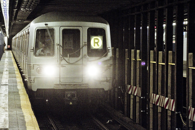
One left Point A in Astoria via the usual means, onboard the so called “R” or Broadway Local Line .
from wikipedia
The R Broadway Local is a rapid transit service in the B Division of the New York City Subway. Its route emblem, or “bullet”, is colored yellow since it uses the BMT Broadway Line in Manhattan.
The R operates local between 71st Avenue in Forest Hills, Queens and 95th Street in Bay Ridge, Brooklyn at all times except nights when it short turns at Whitehall Street–South Ferry in Lower Manhattan from Brooklyn.
– photo by Mitch Waxman
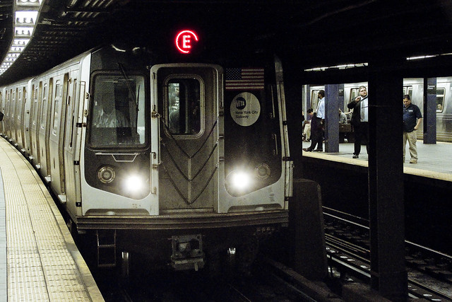
Ultimately, one sought to gain access to the Crosstown or “G” line, which the MTA folks annoyingly force one to enact two transfers to get to from Point A, despite the platform’s location less than a mile and a half from my starting point (and the fact that the G used to run through the same station which I caught the R at). Accordingly, at the sweltering bunker of dripping masonry which the MTA designates as “Queens Plaza,” one debarked the R and vouchsafed a single station ride upon the “E” – or Eighth Avenue Local Line – to the Court Square station where yet another transfer was enacted to access the G.
Urine, it smelled deeply of urine, at the Court Square station.
from wikipedia
The E Eighth Avenue Local is a rapid transit service in the B Division of the New York City Subway. Its route emblem, or “bullet”, is blue since it uses the IND Eighth Avenue Line in Manhattan.
The E operates at all times between Jamaica Center–Parsons/Archer in Jamaica, Queens, and Chambers Street–World Trade Center in Lower Manhattan, running express on the IND Queens Boulevard Line in Queens (except nights when it serves all stops) and local in Manhattan. E trains also serve two local stops in eastern Queens (75th Avenue and Briarwood) on evenings and weekends.

– photo by Mitch Waxman
My penultimate destination, on this particularly warm evening, was Sunset Park – which adjoins the legend choked streets of the Red Hook section of Brooklyn. One does realize, of course, that the R could have taken me all the way to this area which is called “Sunset Park,” but that would have multiplied my travel time due to a circuitous route which transverses all of Manhattan and a good chunk of Brooklyn.
The G discharged a humble narrator, vomiting me forth onto the platforms at the sky flung Smith/9th street station, high over the loathsome and shadow haunted Gowanus Canal. The Gowanus Canal smells of urine (and other things) as well, of course.
from wikipedia
The G Crosstown Local is an 11.4-mile-long (18.3 km) rapid transit service in the B Division of the New York City Subway. Its route emblem, or “bullet”, is colored light green since it uses the IND Crosstown Line.
The G operates at all times between Court Square in Long Island City, Queens and Church Avenue in Kensington, Brooklyn via the IND Crosstown and Culver lines. In Queens, it only serves two stations – Court Square and 21st Street, both in Long Island City – but previously served all stations to and from 71st Avenue in Forest Hills on the IND Queens Boulevard Line.
– photo by Mitch Waxman
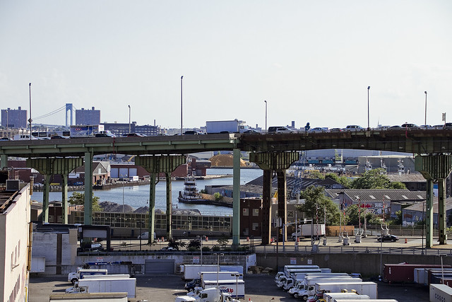
My plan was to pass through the “House of Moses” and under the Gowanus Expressway section of the Brooklyn Queens Expressway, exploiting the shaded path which is offered by this elevated roadway, and head south towards Sunset Park. It should be mentioned, incidentally, that this is perhaps the least pedestrian friendly area in all of Brooklyn. Brobigdagnian trucks whiz about at high speed, angry motorists lurch their vehicles to and fro in frustrated bursts, and the pavement is both shadowed by the expressway above and in a delitorious state of repair.
Also, there’s vampires hiding in the rafters of the Gowanus Expressway.
from nycroads.com
The Gowanus Expressway, which serves as the southern extension of the Brooklyn-Queens Expressway, also connects the Brooklyn-Battery Tunnel approach, the Prospect Expressway (NY 27), the Belt Parkway and the Verrazano-Narrows Bridge. Although guide signs and maps refer to this segment of I-278 as the Brooklyn-Queens Expressway, it is known locally as the Gowanus Expressway.
Beginning in 1939, Robert Moses oversaw construction of the Gowanus Parkway, an elevated highway placed on top of the pillars of the old 3rd Avenue BMT Elevated Line through the Sunset Park and Gowanus sections of Brooklyn. It would eventually become part of a limited-access parkway loop encircling four of the five boroughs. Since the Gowanus Parkway was to be constructed atop a pre-existing elevated facility, Moses had little trouble getting his project approved by the New York City Council.
However, the Gowanus Parkway would require more land for a wide roadway and entrance-exit ramps. This required the demolition of many homes and businesses along Third Avenue, a tightly knit block of Northern and Western European immigrants.

– photo by Mitch Waxman
There are charming sights to be found along the Gowanus Canal, I should mention, lest you think I’m prejudiced against the “Superfund Sister to the South” of my beloved Newtown Creek. Abundant waste transfer and oil distribution facilities, endemic pollution, lakes of unknown chemical constitution lurking just below the streets, untreated sewage oozing out of unmarked pipes? These are all the things I love.
One has never understood the appeal of “going to the country” and vacationing amongst the rural yokels. Camping? Are you insane? I’ve got a dry bed and a door that locks here in NYC, where I get to witness a looming infrastructure crisis and unfolding environmental apocalypse whenever I want to.
from wikipedia
The Gowanus Canal is a canal in the New York City borough of Brooklyn, on the westernmost portion of Long Island. Connected to Gowanus Bay in Upper New York Bay, the canal borders the neighborhoods of Red Hook, Carroll Gardens, and Gowanus, all within South Brooklyn, to the west; Park Slope to the east; Boerum Hill and Cobble Hill to the north; and Sunset Park to the south. It is 1.8 miles (2.9 km) long. There are seven bridges over the canal, carrying Union Street, Carroll Street (a landmark), Third Street, Ninth Street, Hamilton Avenue, the Gowanus Expressway, and the IND Culver Line of the New York City Subway.

– photo by Mitch Waxman
That’s part of the Gowanus Canal, pictured above, as shot from the Hamilton Avenue Bridge and looking back north towards the Smith/9th street station which the G line disgorged me into. Used as I am to the wild expanses and geographic extent of Newtown Creek, my thoughts always turn to compactness when I’m at the Gowanus. Thing is, just like Newtown Creek and its tributaries – two of which the Gowanus would tuck neatly into – the canal interacts with ground water and flows beneath the streets via its connections with the sewer system. Just like Newtown Creek, many of the sewers connected to the Gowanus are in fact former tributary waterways which were converted and buried at the end of the 19th and start of the 20th centuries. Who can guess, all there is, that might be buried down there?
Additionally, both Gowanus Canal and Newtown Creek sport maritime industrial bulkheads along most of their length which are little more than artifacts of the Second Industrial Age, in our modern day NYC.
from nyc.gov
The Hamilton Avenue Bridge is a bascule bridge with two parallel leafs, one carrying the northbound roadway and the other carrying the southbound roadway. Most of the length of Hamilton Avenue runs below the elevated portion of the Gowanus Expressway, including the bridge. The bridge connects Smith Street and Second Avenue over the Gowanus Canal and is the first canal crossing north of the Gowanus Bay.

– photo by Mitch Waxman
Regardless of musings about the wasted space, lack of public access, and utter degradation of the air, water, and soil – one had somewhere to be, and a little bit of walking was required to get there. A humble narrator put his head down, leaned into a southerly declination, and scuttled off into the clouds of auto exhaust mixing with the humid air.
The Gowanus Expressway dwelling Vampires be damned, I needed to get to Sunset Park.
from wikipedia
A vampire is a being from folklore that subsists by feeding on the life essence (generally in the form of blood) of the living. In European folklore, vampires were undead beings that often visited loved ones and caused mischief or deaths in the neighbourhoods they inhabited when they were alive. They wore shrouds and were often described as bloated and of ruddy or dark countenance, markedly different from today’s gaunt, pale vampire which dates from the early 19th century.
Vampiric entities have been recorded in most cultures; the term vampire, previously an arcane subject, was popularised in the West in the early 19th century, after an influx of vampire superstition into Western Europe from areas where vampire legends were frequent, such as the Balkans and Eastern Europe; local variants were also known by different names, such as shtriga in Albania, vrykolakas in Greece and strigoi in Romania. This increased level of vampire superstition in Europe led to mass hysteria and in some cases resulted in corpses being staked and people being accused of vampirism.
Upcoming Tours and events
The Insalubrious Valley of the Newtown Creek Walking Tour, with Newtown Creek Alliance – Saturday August 5th, 11 a.m. – 1;30 p.m.
Century old movable bridges, the remains of a 19th century highway between Brooklyn and Queens, and explore two of the lesser known tributaries of the troubled Newtown Creek watershed. For the vulgarly curious, Conrad Wissell’s Dead Animal and Night Soil wharf will be seen and described, with NCA Historian Mitch Waxman – details here.
Brooklyn Waterfront Boat Tour, with Working Harbor Committee – Saturday August 12th, 6 p.m. – 8 p.m.
Explore the coastline of Brooklyn from Newtown Creek to Sunset Park, with NCA Historian Mitch Waxman, Andrew Gustafson of Turnstile Tours, and Gordon Cooper of Working Harbor Committee on the narrating about Brooklyn’s industrial past and rapidly changing present. – details here.
The Poison Cauldron of the Newtown Creek Walking Tour, with Newtown Creek Alliance – Sunday August 13th, 11 a.m. – 1:30 p.m.
Explore the hellish waste transfer and petroleum districts of North Brooklyn on this daring walk towards the doomed Kosciuszko Bridge, with NCA Historian Mitch Waxman – details here.
Two Newtown Creek Boat Tours, with Newtown Creek Alliance and Open House NY – Wednesday August 16th, 5 p.m. and 7 p.m.
The neighborhoods surrounding Newtown Creek are home to the densest collection of these garbage facilities anywhere in the city and collectively, the waste transfer stations around and along Newtown Creek handle almost 40% of the waste that moves through New York. Join Newtown Creek Alliance’s Mitch Waxman and Willis Elkins to learn about the ongoing efforts to address the environmental burden that this “clustering” has caused. – details here.
“follow” me on Twitter- @newtownpentacle
so dissimilar
Places to go, no one to see.

– photo by Mitch Waxman
Over at Newtown Creek’s LIC tributary, Dutch Kills, a property owner has been clearing away a stand of poison ivy and feral trees which have been occluding views of the turning basin (47th avenue at 29th street). There’s a bit of controversy about the property owner’s plans to erect a fence line here, as it seems to be NYS property, but this is Queens so who cares? If this was North Brooklyn, there’d be hunger strikers and hipster girls would be chaining themselves to the bulkheads. Here, the primary impact on the community is the loss of a good spot for weed smoking used by students from a nearby college and high school.

– photo by Mitch Waxman
Last weekend, Working Harbor Committee did a tour of the Gowanus Bay and Canal which I was onboard for. Conversation with members of the Gowanus Conservancy allowed me to utter aloud one of the “faux pas” for which I am famous. My statement that Newtown Creek is a FAR bigger problem than their troubled waterway was greeted with “oh, here we go.” I explained that its geography, and that Newtown Creek and its tributaries simply occupy more space than the Gowanus. Closest analogy for the Gowanus, in my opinion, is actually Dutch Kills – multitudes of bridges, overflown by a highway, narrow channel, and abandoned bulkheads.

– photo by Mitch Waxman
Got me thinking about Luyster Creek and all the other largely abandoned industrial canals in Queens that never get mentioned, of course. Flushing River, Anable Basin, and the rest seldom receive much notice from regulators. They’ve got the Black Mayonnaise and the VOC’s, the CSO’s and PCB’s. Heck, the entire alphabet can found floating around in New York Harbor. Staten Island’s Kill Van Kull is so rich in pesticides that it could likely wipe out every roach in Manhattan.
“follow” me on Twitter- @newtownpentacle


