Posts Tagged ‘newtown creek’
blissville update

– photo by Mitch Waxman
Just in case you were wondering, not too much new to report on the oil situation in Blissville Queens, which is found on the northern shore of the lamentable Newtown Creek. Our friends at Riverkeeper continue to investigate, as do everyone’s friends at the State DEC. Conversation with highly placed members of both organizations indicate that they have people working on it.
These photos from the beginning of February in 2012 would seem to dispute that. Compare to the same area in August 2011.

– photo by Mitch Waxman
The conversations were informal, and were initiated by your humble narrator. Concurrently, I’m not going to “report” the substance of these exchanges yet, as I’m not “that kind” of blogger. “That kind” would seek to embarrass or denigrate the process and participants for puerile amusement and or self advancement. This is not the case, and I draw a line between what a source tells me privately versus publicly. Suffice to say that things are moving along and that you catch more flies with honey than with vinegar.
The Newtown Creek Alliance is aware of the issue as well, and we are working on it.

– photo by Mitch Waxman
Some of you may have noticed that I said “we” referring to NCA, and in accordance with some standard of full disclosure which only one such as myself adheres to- the group has awarded me the title of “Historian”. I’m picking up the fallen banner of my friend and mentor, Bernie Ente, and will strive to earn the honor by continuing to reveal the occluded history of this place.
The initial assessment of the leak, as presented in the posting “oil in queens” back in December of 2011 has garnered little attention from the mainstream press. The sole venue which ran a story on it is the DNAinfo website, their posting can be accessed here. If this was Manhattan, I’d be fighting the NYTimes for access.
But seriously, who cares anything about Queens?
ALSO:
March 5th, as in tonight:
Riverkeeper and NCA ask: How’s the Water? How’s Newtown Creek?
Join Riverkeeper and the Newtown Creek Alliance for a presentation on water quality in the Hudson River Estuary and its tributaries, focusing on the waters around Manhattan Island and in Brooklyn’s Gowanus Canal and Newtown Creek.
March 5, 2012, 7:30PM to 9:30PM
Brooklyn Brewery, 79 North 11th Street, NY map
and March 6th, as in Tuesday

rhetorical effect

– photo by Mitch Waxman
There is a curious stretch of 50th avenue, a truncated street that starts at 27th street and terminates at 23rd street in the dusty streets of Long Island City, which is orphaned and decapitated. It is dominated by the high flying steel of the Queens Midtown Expressway section of the Long Island Expressway, and the tortured asphalt of the street it shadows often exhibits bursting ruptures revealing century old cobble stones.
Long have I exerted to refer to this area as the “Empty Corridor“.
Pictured above are the relict remains of Irving Subway Grate, which suffered a catastrophic fire a few years back.

– photo by Mitch Waxman
Even during the work week, there are few places in New York City that allow one to feel so isolated and alone as this street. Once it connected with Hunters Point, but that was long before the Queens Midtown Tunnel and the astounding steel viaduct of the Long Island Expressway which sprouts from it were installed and opened to traffic on November 15, 1940.
It was before the Long Island Railroad established its operations that it met with East River, in fact.
Borden and Hunters Point Avenues are the main through way for traffic heading east and west, and this street is little more than relict of earlier times.

– photo by Mitch Waxman
The overhead tracks of the Long Island Railroad are observed at the intersection of 25th street, which govern the passage of large trucks on 50th avenue. Never have these tracks been observed as active by a humble narrator, but those in the know about such matters assure me that they are in fact transited.

– photo by Mitch Waxman
Alongside these tracks, on the loamy midden which surrounds them, one might observe the colonies of feral cats which hunt and frolic around these parts. The kind hearts of area workers insure that these cats are afforded shelter and food, which unfortunately allows them to breed and multiply.
It is not an easy life, to be a feral cat.

– photo by Mitch Waxman
As mentioned in the past, when these nocturnes are observed as my perambulations carry the camera about the concrete devastations of western Queens, a sure notion that the right place and time have been arrived at sets into my mind.
Always, they signal that the path which stretches before me is an appropriate and often revelatory one.

– photo by Mitch Waxman
Beyond the tracks and their feline neighbors, the gargantuan structure with its attendant loading docks on the right are the former Bloomingdales warehouse, and is currently used by the New York City Housing Authority. They refer to it as the “Long Island City Complex” which sounds menacing somehow.
The left (or south) side of the street hosts several garage based businesses, and mainly acts as a parking lot for fleet trucks.

– photo by Mitch Waxman
As the LIE slouches rudely toward the Queens Midtown Tunnel it descends from its 106 foot apex over Dutch Kills, just a few blocks away, and the street noticeably darkens. A guarded parking lot and entrance to the LIRR station lies to the right or north side, which is intended for employee access. To the south, one might follow 23rd street southward, toward Borden Avenue.
An audible hum, the sound of automotive tire spinning upon the elevated roadway above, colors the air.

– photo by Mitch Waxman
The street ends in the driveway of a steel equipment company, which a humble narrator did not feel obliged to explore. What atavist wonders might lurk down there are surely beyond legal access, and are quite visible from the fence which adjoins the LIRR station on Hunters Point Avenue, near the Paragon Oil building. Surely some revelation hides back there, denied to me.
Illegal trespass, however, is not the Newtown Pentacle way.
sitting alone

– photo by Mitch Waxman
All ‘effed up.
In one of those odd moments which often cause my steps to falter, whilst walking down hoary Kingsland Avenue in ancient Greenpoint, this discarded workman apparel seemed to be trying to tell me something.
Clearly, it was pointing at something.
from wikipedia
Ideas of reference and delusions of reference involve people having a belief or perception that irrelevant, unrelated or innocuous phenomena in the world refer to them directly or have special personal significance: ‘the notion that everything one perceives in the world relates to one’s own destiny’.
In psychiatry, delusions of reference form part of the diagnostic criteria for psychotic illnesses such as schizophrenia, delusional disorder, or bipolar disorder during the elevated stages of mania. To a lesser extent, it can be a hallmark of paranoid personality disorder. Such symptoms can also be caused by intoxication, especially with hallucinogens or stimulants like methamphetamine.

– photo by Mitch Waxman
For a moment, the ridiculous notion that its missing owner was in mid gesture and then suddenly dissolved away struck me. The fence seen behind the glove is laden with signs that promise electrocution to those who might attempt trespass of the property it surrounds, and I thought that perhaps its owner had ignored these warnings and had been consumed by torrents of voltage and the sole survivor of the man was this garment.
That’s when I thought “perhaps it’s trying to tell me to look behind me, and offering a warning”.
People suffering from persecutory delusions believe that they are being conspired against or persecuted in some way. Common manifestations include the belief that one is being followed, that one’s mail is being opened, that one’s room or office is bugged, that the telephone is tapped, or that police, government officials, neighbors, or fellow workers are harassing the subject.

– photo by Mitch Waxman
Luckily, nothing was amiss, and your humble narrator remained the lord of his near vicinity.
“I’m all ‘effed up” was all I said, out loud, and then continued walking back to Queens.
also from movementdisorders.org
The subject’s behavior is unusual, bizarre, or fantastic. For example, the subject may urinate in a sugar bowl, paint the two halves of his body different colors, or kill a litter of pigs by smashing their heads against a wall. The information for this item will sometimes come from the subject, sometimes from other sources, and sometimes from direct observation. Bizarre behavior due to the immediate effects of alcohol or drugs should be excluded. As always, social and cultural norms must be considered in making the ratings, and detailed examples should be elicited and noted.
curious heaps

– photo by Mitch Waxman
Like Thoreau, your humble narrator occasionally needs to escape it all and commune with the beasts of the field on their own terms. Journey toward nature and become as one with it, all that. Accordingly, a recent perambulation was embarked upon whose destination would reward me with the presence of creatures for whom freedom is no abstract notion, rather it is their daily experience.
from wikipedia
Walden (first published as Walden; or, Life in the Woods) is an American book written by noted Transcendentalist Henry David Thoreau. The work is part personal declaration of independence, social experiment, voyage of spiritual discovery, satire, and manual for self reliance.
Published in 1854, it details Thoreau’s experiences over the course of two years in a cabin he built near Walden Pond, amidst woodland owned by his friend and mentor Ralph Waldo Emerson, near Concord, Massachusetts.
By immersing himself in nature, Thoreau hoped to gain a more objective understanding of society through personal introspection. Simple living and self-sufficiency were Thoreau’s other goals, and the whole project was inspired by transcendentalist philosophy, a central theme of the American Romantic Period. As Thoreau made clear in his book, his cabin was not in wilderness but at the edge of town, about two miles (3 km) from his family home.

– photo by Mitch Waxman
Unfortunately, despite the unseasonably warm temperatures of recent weeks, it is still winter- limiting my options for observing natures bounties. There will always be birds exploiting safe harborage, it was reasoned, so my steps headed for the shoreline.
There I found my reward as small flocks of birds were exploiting the mud flats typical of estuarine coastlines.
from Walden (1854) by Henry David Thoreau, courtesy en.wikisource.org
What is a country without rabbits and partridges? They are among the most simple and indigenous animal products; ancient and venerable families known to antiquity as to modern times; of the very hue and substance of Nature, nearest allied to leaves and to the ground — and to one another; it is either winged or it is legged. It is hardly as if you had seen a wild creature when a rabbit or a partridge bursts away, only a natural one, as much to be expected as rustling leaves. The partridge and the rabbit are still sure to thrive, like true natives of the soil, whatever revolutions occur. If the forest is cut off, the sprouts and bushes which spring up afford them concealment, and they become more numerous than ever. That must be a poor country indeed that does not support a hare.

– photo by Mitch Waxman
Unlike Thoreau, I have no virginal woodlands with an untouched body of water to retreat to, rather my lot is to yearn for the accursed East Branch of the hated Newtown Creek. Saying that, however, there is a mythology about this body of water which I have become keen to dispel.
This ain’t a dead place, it’s actually teeming with life. Unfortunately, it’s not the cuddly or cute kind of life- instead there are mainly worms, bugs, and other creepy crawlies for whom these anaerobic mudflats are a nutrient rich paradise. The hypoxic state of the water actually reduces the number of potential predators they might encounter.
It’s precisely this sort of critter, who live in the sediment mounds of the Newtown Creek, that the lovely birds in the shots above are feeding on.
from wikipedia
Hypoxia, or oxygen depletion, is a phenomenon that occurs in aquatic environments as dissolved oxygen (DO; molecular oxygen dissolved in the water) becomes reduced in concentration to a point where it becomes detrimental to aquatic organisms living in the system. Dissolved oxygen is typically expressed as a percentage of the oxygen that would dissolve in the water at the prevailing temperature and salinity (both of which affect the solubility of oxygen in water; see oxygen saturation and underwater). An aquatic system lacking dissolved oxygen (0% saturation) is termed anaerobic, reducing, or anoxic; a system with low concentration—in the range between 1 and 30% saturation—is called hypoxic or dysoxic. Most fish cannot live below 30% saturation. A “healthy” aquatic environment should seldom experience less than 80%. The exaerobic zone is found at the boundary of anoxic and hypoxic zones.

– photo by Mitch Waxman
Across the City, State, and even the Nation- engineers are working feverishly on grand designs and byzantine plans whose purpose it is to “fix” Newtown Creek. Many are experts on the place, and can quote a staggering amount of raw data about it from memory, but so few of them have ever actually been here.
It’s as if one can say they understand a neighborhood because they’ve memorized its map and boundaries.
When confronted with the fact that birds, including exotic specimens like egrets, cormorants, and herons are nesting along its banks- to appropriate a term from the British- “they are gob smacked”.
from wikipedia
Tidal flats, along with intertidal salt marshes and mangrove forests, are important ecosystems. They usually support a large population of wildlife, although levels of biodiversity are not particularly high. They are often of vital importance to migratory birds, as well as certain species of crabs, mollusks and fish. In the United Kingdom mudflats have been classified as a Biodiversity Action Plan priority habitat.
The maintenance of mudflats is important in preventing coastal erosion. However, mudflats worldwide are under threat from predicted sea level rises, land claims for development, dredging due to shipping purposes, and chemical pollution.

– photo by Mitch Waxman
Don’t misunderstand, this is an extremely troubled waterway, and the biomass which it should be supporting is exponentially higher than what you’ll find living here today. The early Creek, the one that the Dutch encountered, was known for an abundant biosphere. All of the highest forms of the mammalian, ichthian, and avian species were here in great numbers- everything from pike to bass to shrimp swam in it, deer and bears and wolves were roaming the hills adjoining the salt marshes and coastal wetlands and hawks, owls, and eagles were described as soaring overhead.
Such fauna obviously won’t be coming back, but there are still fish swimming around here. Not big fish, but fish nevertheless. They eat the creepy crawly things too.
from wikipedia
A tidal creek, tidal channel, or estuary is the portion of a stream that is affected by ebb and flow of ocean tides, in the case that the subject stream discharges to an ocean, sea or strait. Thus this portion of the stream has variable salinity and electrical conductivity over the tidal cycle. Due to the temporal variability of water quality parameters within the tidally influenced zone, there are unique biota associated with tidal creeks, which biota are often specialised to such zones.
Creeks may often dry to a muddy channel with little or no flow at low tide, but often with significant depth of water at high tide.

– photo by Mitch Waxman
What chance can such an environment stand with an open sewer the size of an 18 wheeler truck, though?
See, my version of Walden Pond is rent asunder by CSO Outfall NC-083, which discharges an average of 586 million gallons of filth into the East Branch of Newtown Creek per year.
from habitatmap.org
Combined Sewer Outfall NC-083 discharges approximately 586 million gallons of untreated wastewater year into Newtown Creek. This accounts for 2.2% of New York City’s total sewer overflow into the estuary.
This CSO is ranked at #15 out of the 434 permitted outfalls in the city, by volume. It is located alongside a second, smaller, CSO outfall, NC-019.
lethal foliage

– photo by Mitch Waxman
Would that a humble narrator might tell you that these shots were captured whilst riding upon some Hedorah like cacodaemon, but it was actually during one of last fall’s Newtown Creek Tours and onboard an entirely mundane NY Water Taxi that the subject of this “Maritime Sunday” posting was photographed.
As you can see, something was advancing toward us on the Newtown Creek that day, something newly born.
from epa.gov
Newtown Creek, located in the City of New York, is a part of the New York – New Jersey Harbor Estuary and forms the northern border of the Borough of Brooklyn and the southern border of the borough of Queens. In the mid 1800s, the area adjacent to the 3.8 mile Newtown Creek was one of the busiest hubs of industrial activity in New York City. More than 50 refineries were located along its banks, including oil refineries, petrochemical plants, fertilizer and glue factories, sawmills, and lumber and coal yards. The creek was crowded with commercial vessels, including large boats bringing in raw materials and fuel and taking out oil, chemicals and metals.

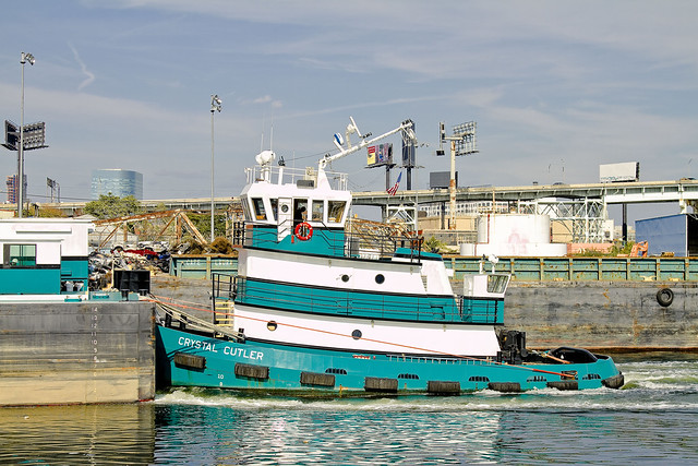
– photo by Mitch Waxman
Built Nov. 04, 2010- this is the tugboat Crystal Cutler and her articulated barge (the Patricia E. Poling) plying the Newtown Creek. The article linked to below will tell you everything you could possibly ask about this tug and those who Captain and command her.
What mysteries they might have witnessed along the Creek, however, are not discussed in this profile.
The 70-foot, 1,500-hp twin-screw tug Crystal Cutler has been pushing and occasionally towing a 15,000-barrel clean oil barge since the tug was introduced in 2010. The tug places a high demand on her captains and crews as she ventures into shallow rivers and estuaries, moving about in a highly dynamic harbor with loads of gasoline, fuel additives or heating oil for small oil terminals.

– photo by Mitch Waxman
Amongst the larger harbor community, Newtown Creek is seldom referred to in glowing terms. There are those who dispute its role and historical significance to the maritime industry- as their eyes and hearts are drawn to the Brooklyn Navy Yard, the West Side of Manhattan, and the gargantuan modern ports in New Jersey.
Many would like to abandon it as an industrial corridor entirely, saying that its day as a working waterway is done, and give it over to kayaking and other recreational occupations.
Founded in 1995, Poling Cutler began operations near the time the former Poling Transportation went out of business.
The Founders of the new company were Ed Poling, whose grandfather started the former Poling company, and Gary Cutler who spent years working in the financial world before getting involved in Marine Transportation.
– photo by Mitch Waxman
One of the greatest sins along the Newtown Creek is precisely how few of its docks are utilized today. Most of the modern business along the Creek looks toward truck transportation to bring their goods to market and for the delivery of raw materials, ignoring their valuable docking rights and imprimature. Miles of bulkheads, expensively installed during prior generations, are allowed to rot away.
What a wasted opportunity.
Moving essential bulk materials by barge is more efficient economically and environmentally. From what we hear, a single barge has the same capacity as 28 – 56 long haul trucks, depending on the industry. Compared to other transportation modes, barge transport of bulk materials is safer in terms of worker injuries and generates far fewer emissions of particulate matter, hydrocarbons, carbon monoxide, CO2 and nitrous oxide on a per ton mile moved basis.
Despite the critical importance of barge transport as a best practice for industries on Newtown Creek, much of the bulkhead along this waterway is in disrepair. Overall bulkhead condition reveals a trend of disinvestment in maritime transit and a decline in related industries. According to Army Corps of Engineers, there were 19 businesses with working docks in 1999, compared to the nine that remain active today, as of January 2011.

– photo by Mitch Waxman
When you boil it down, the whole purpose of the Newtown Creek in its current form is to bring bulk goods into New York City by barge. Admittedly, the days of Standard Oil, Phelps Dodge, and the great Lumber interests are long gone- but… imagine some farmers in upstate New York loading their harvest goods onto a barge, and sending a floating green market directly to Long Island City or Greenpoint or even Maspeth. The barge could return to the farmer laden with cash and whatever else might be needed for the next harvest, completing a virtuous circle.
Imagine standing on the shoulders of giants, rather than rifling through their corpses like so many bugs.
from dot.ny.gov
Commercial and industrial development along Newtown Creek began circa 1854-60 and accelerated rapidly, spurred by low land values, water access for ships and boats, and relative remoteness from populated areas or regulations. The first kerosene refinery in the United States (1854) and modern oil refinery (1867) helped transform Newtown Creek into an industrial waterway. The first few industries also included a distillery near the Newtown side of the Penny Bridge, and the Peter Cooper glue factory relocated from elsewhere in Greenpoint to a site in Bushwick north of Maspeth Avenue10. The influx of industry and jobs, aggressive real estate development in and around Hunter’s Point, including LIRR’s presence on the creek in 1861, and the explosive growth of refined petroleum products all enhanced Newtown Creek’s attractions and helped transform the drainage into an industrial waterway circa 1860-1880. At the Industrial Revolution’s height, Newtown Creek’s industries were flourishing, bringing thousands of people to work at its plants and factories.

– photo by Mitch Waxman
The United States Coast Guard sometimes refers to Newtown Creek as part of “America’s Maritime Superhighway”, a vital industrial waterway which must be protected from the interests of those too short sighted to realize its potential to reinvigorate the economies of those communities through which it flows. It is the very definition of the future, and New York’s destiny is and has always been directly linked to it.
It’s heart warming to see clear eyed mariners like those onboard the Crystal Cutler plying its waters.
from nycppf.org
Significant Maritime and Industrial Area
Newtown Creek, at over 780 acres the city’s largest SMIA, abuts portions of the Greenpoint, Williamsburg, Long Island City, and Maspeth industrial areas. The waterfront area is characterized by heavy industry and municipal facilities, many of which are water- dependent. Newtown Creek is also the largest SMIA in terms of employment.
Although from 1992 to 2008 the SMIA lost roughly half its jobs, from 2000 to 2008 the number of jobs in the SMIA grew by nearly 1,400 to reach a total of approximately 15,000 jobs. Nearly half of the jobs in 2008 were in transportation and warehousing and wholesale trade. However, the business mix is becoming much more diverse. In the eight-year period examined, non-industrial jobs grew by more than 35 percent.


