Posts Tagged ‘English Kills’
Archives #013
Wednesday

– photo by Mitch Waxman
My beloved Creek, how I miss thee… This shot looks towards Brooklyn’s Greenpoint from LIC’s Blissville along the Greenpoint Avenue Bridge. What’s missing here is a rail bridge which used to connect LIRR freight trains to the Brooklyn side, where the Mobil Refinery used to stand.
Today, another archives post from broken ankle country (#brankle) greets you, with all represented posts having been originally presented on this date in their respective years.
This 2015 post discusses the garbage train in LIC’S Blissville section.

– photo by Mitch Waxman
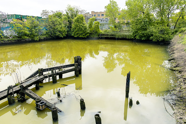
I always figured that if I broke an ankle it would be all the way back in Brooklyn at the end of English Kills, which is also the end of Newtown Creek, and is found some 3.8 miles from the East River. I never liked going back here alone, either. Too easy to get hurt and too difficult to get help if you did.
This 2017 post visits the actual last mile of Newtown Creek in Brooklyn.

– photo by Mitch Waxman
End of December in 2022 is when I left NYC and moved to Pittsburgh. No regrets, I would add. Again, it’s an interesting thing for me to recollect about the actual sensory experience of this particular day when viewing the photos. I remember the day this shot was captured as offering near perfect weather conditions for a long walk.
This 2023 post from October 23 involved me trying to ‘get back on the stick’ exercise wise, after an interval of being stuck at home while caring for Our Lady of the Pentacle after she endured a medical procedure. A year later and our positions have reversed, and I’m the one in trouble.
Back tomorrow.
“follow” me on Twitter- @newtownpentacle
Buy a book!
“In the Shadows at Newtown Creek,” an 88 page softcover 8.5×11 magazine format photo book by Mitch Waxman, is now on sale at blurb.com for $30.
grassy cobbles
Monday

– photo by Mitch Waxman
Last week, one described the circumstances of a navigation of Newtown Creek on September 27th during which the photos in today’s, and prior postings, were captured. The small boat I was riding in had been navigated all the way back to the Metropolitan Avenue Bridge by it’s Captain – Carter Craft. There’s still a bit of navigable water beyond this span, a double bascule drawbridge owned and operated by the NYC DOT, but I seldom go back there in anything larger than a rowboat and I don’t do that often at all.
Down Under the Metropolitan Bridge Onramp or DUMABO, that’s how I “tag” anything which I’ve written about this bridge, or the area directly surrounding it in Brooklyn. The English Kills tributary of Newtown Creek is entirely contained within the political boundaries of the Borough of Brooklyn, in its East Williamsburgh section.

– photo by Mitch Waxman
English Kills is entirely hidden from view on the surrounding streets. A once natural waterway canalized by the various Corporate entities which once housed themselves here, and the United States Army Corps of Engineers. From the surrounding streets, you’d never know it was there if it wasn’t for the industrial noises and horrific smell. The odor is not unlike what you’d expect were you were to shit into a bucket of rubber cement thinner, and then set it out to sit in direct sunlight, while a running diesel engine out gassing exhaust. The sound is a “constant din” as in there’s no specific point source for it, rather there’s an atmosphere of noise echoing off the factory and warehouse walls.
The canalized shape of English Kills follows the jigsaws grid of the surrounding streets, which causes its waters to stagnate around the right angled turns. The presence of CSO’s – or Combined Sewer Outfalls – all along Newtown Creek means that the only fresh water entering English Kills comes from these upland drains. This flow is a mix of storm water, road runoff, and sewage. The latter is full of piss and poop, if you need me to point that out. The runoff and storm water washes through the neighborhoods first, carrying garbage and whatever might have dripped out of vehicles passing by on the roadways, and then into the stagnant water column of the tributary.
Because of the stagnation, a bed of sedimentation sits 15-20 feet thick under the surface of the water, sometimes poking out into the air at low tide. The sediments are referred to as “Black Mayonnaise.”

– photo by Mitch Waxman
Historic records suggest that the natural waterway that was once here, prior to colonization by the Dutch, was fed by upland streams and rock springs running down into the waterway’s basin from the highlands surrounding it, in modern day Maspeth, Ridgewood, and Bushwick. It’s the availability of that fresh water bubbling up from the rock springs that drew German beer breweries to establish themselves in these areas. The springs were capped, and the ground water claimed. That was the first industrial nail in the coffin of this part of the larger waterway. Contaminants and pollution from industrial plants literally miles away on the Creek would end up getting pushed back here and since there was nothing tidally pushing back, the bad stuff settled to the bottom. The Black Mayonnaise encountered “here” can be very different from conditions encountered “there,” despite the fact that it’s the same water body. Even on English Kills, the section you’re looking at in the shot above is entirely different from the hellscape found a half mile away in the zone around the apocalyptic Montrose Avenue Railroad Bridge nearby Newtown Creek’s terminus, at Bushwick’s Johnson Avenue.
Few of the modern businesses on English Kills use their maritime bulkheads, once amongst the most valuable in NY Harbor or even the world due to the nearby Evergreen Line Railroad tracks – which are today’s Long Island Railroad Bushwick Branch tracks.

– photo by Mitch Waxman
Open sewers dating back to the Civil War are seen here.
English Kills is the extermination of ration and hope, and a cautionary tale about municipal indifference. The NYC DEP, who operate those CSO drains mentioned above, found themselves under regulatory scrutiny by New York State a few years ago due to the low levels of oxygen present in these waters. The low oxygen situation is caused by sewage bacteria, which they allow into the Newtown Creek via the CSO’s. The answer DEP came up, since doing anything at all about the outflows themselves would be very expensive to the City, was to instead build an aeration system into the waterway. Giant bubble wands, reminiscent of a hobbyist aquarium’s setup, pump air into the water, which causes surface turbulence. These bubbles theoretically cause atmospheric oxygen to diffuse into the water.
The air flow also introduces mechanical energy into the bottom sediments and causes them to rise and coat the shorelines, where the so called black mayonnaise becomes exposed to the air.

– photo by Mitch Waxman
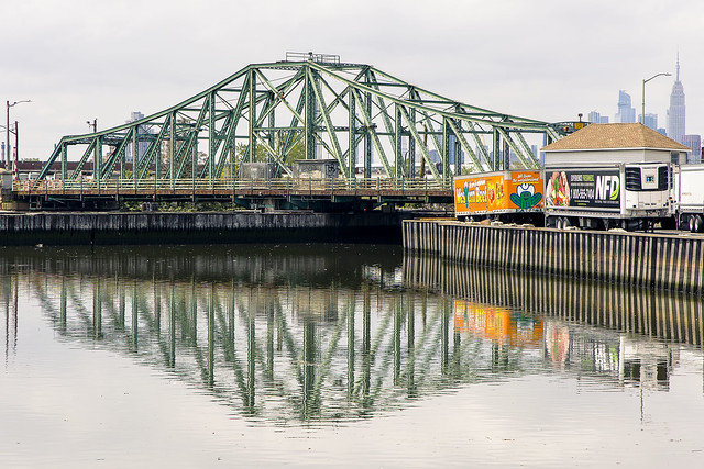
Grand Street Bridge, a swing bridge, is pictured above. The center of that bridge is where the currently undefended border of Brooklyn and Queens is found. If hostilities ever break out, this will be a flash point and no man’s land where campaigns of armed attrition will play out.
Our time on Newtown Creek was nearing an end and my pal Carter captained us back toward Greenpoint, and the Manhattan Avenue Street End where he picked us up earlier in the day. A humble narrator was on an emotional roller coaster, it should be admitted.
“Every time might be the last time.”

– photo by Mitch Waxman
Along our journey back in the direction of the East River, nearly three miles back on the Maspeth side, we saw a guy fishing in Newtown Creek.
Tomorrow, more! And then even more! More all the time, now with extra more! Now – more than ever – more!
“follow” me on Twitter- @newtownpentacle
Buy a book!
“In the Shadows at Newtown Creek,” an 88 page softcover 8.5×11 magazine format photo book by Mitch Waxman, is now on sale at blurb.com for $30.
jaded sensibilities
Tuesday
– photo by Mitch Waxman
On May 15th, a humble narrator was helping out a couple of my buddies from Newtown Creek Alliance on a walking tour of the eastern side of the creek – in East Williamsburgh, Maspeth, and Ridgewood.
Pictured is the end of all hope at Newtown Creek’s English Kills tributary in the East Williamsburgh area. This is some 3.8 miles from the East River.

– photo by Mitch Waxman
Water conditions back here are as bad as they get on Newtown Creek, and that’s really saying something. There’s lots of oil sheens, the water has virtually zero oxygen in it, and the only source of fresh water coming into this area other than the infinitesimal influences of the tidal cycle emerge from one of the largest open sewers in NYC, found at the head of the canal.
It smells like rotting ham and wet reptiles back here.

– photo by Mitch Waxman
On the north side of English Kills is one of Waste Management’s transfer stations, one which is connected to the Bushwick Branch Long Island Railroad freight tracks. This is the same rail you see behind Flushing Avenue in Maspeth, and which leads to the Fresh Pond Yard found to the north east.
That’s the garbage train pictured above. Normally, when I show you this sort of thing, it’s nearby the Review Avenue Waste Management facility which is in Long Island City’s Blissville section.
– photo by Mitch Waxman
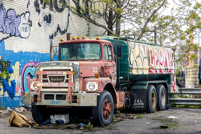
Nearby the Metropolitan Avenue Bridge, this derelict tanker truck caught my eye. It’s sitting alongside the Manhattan Polybag site, which is currently abandoned and being worked on/remediated for toxic materials that were being released into the water. The NYS Department of Environmental Conservation is in charge of this one.
Nothing but happiness and joy at the fabulous Newtown Creek, I always say. Happiness and joy…

– photo by Mitch Waxman
Another tributary of Newtown Creek on the eastern side of its course is called “The East Branch.” It splits like a letter “Y” at the Grand Street Bridge. One section of it terminates at Metropolitan Avenue nearby Scott Avenue in Ridgewood, and it’s there that you’ll find the fourth largest open sewer in NYC.
Happiness and joy…
– photo by Mitch Waxman
The other section of the East Branch forms a short barge sized canal, which is visible from the Western Beef supermarket’s parking lot. There’s a nice view there, pictured above, of the Grand Street Bridge.
Get your shots of this centuried span while you can, the City is in the earliest phases of replacing the thing.
“follow” me on Twitter- @newtownpentacle
Buy a book!
“In the Shadows at Newtown Creek,” an 88 page softcover 8.5×11 magazine format photo book by Mitch Waxman, is now on sale at blurb.com for $30.
have unlocked
Wednesday

– photo by Mitch Waxman
Tired and overwhelmed is a humble narrator, who is out taking pictures of the greatest city in the history of mankind this week and not attending any Zoom meetings or frankly doing anything he doesn’t want to do. Thereby, this week you’ll be encountering single images here at Newtown Pentacle, in pursuance of taking a short break from the normal blather.
Pictured above is the eastern terminus of the fabulous Newtown Creek, found some 3.8 miles back from the East River in Bushwick/East WIlliamsburg.
“follow” me on Twitter- @newtownpentacle
Buy a book!
“In the Shadows at Newtown Creek,” an 88 page softcover 8.5×11 magazine format photo book by Mitch Waxman, is now on sale at blurb.com for $30.
shattered nerves
English Kills, at night.

– photo by Mitch Waxman
So this is where a humble narrator found himself last evening, but as I had good company with me, one was only mildly terrified by the solemnified majesty of Newtown Creek. This is near the end of all things, where Newtown Creek’s tributary English Kills flows into a sewer which also flows into English Kills. Dichotomies notwithstanding, that’s the Montrose Avenue Railroad Bridge in the left of the shot, which carries the tracks of the Long Island Railroad’s Bushwick Branch over the waterway, and into the luminance of Waste Management’s Varick Street location. It was windy.
This is Brooklyn, roughly 3.7 miles from the East River.

– photo by Mitch Waxman
There were rats.
As my pal Bernie Ente used to advise “the rats at Newtown Creek are well fed and won’t bother you, they don’t care that you’re there, but they might run over your feet.” That didn’t happen, foot wise, but my companion and I did spot a few plump specimens skittering between the shadows. The biggest issue encountered, actually, was when we followed a trod upon path around the borders of the canalized waterway. The brush is still thick, and there were a few fallen trees to contend with, but we were determined to gain access to the spot where the story of Newtown Creek suddenly stops.
That spot has a designation: NC-015.

– photo by Mitch Waxman
The mounds of litter and garbage that mix with and provide firmament to a tangle of self seeded vegetation and fallen trees can simply be described as “a trip hazard,” but there were more than a few spots encountered on the way to this location that could have easily ended with a broken ankle. It was quite dark, being night time, it should be mentioned. A portable light was used to illuminate the foreground in the shot above, but prior to that it was a silhouette against the water.
3.8 miles from the East River, the western facing point of view above is from above Combined Sewer Outfall #NC-015. It’s the 20th largest of the 400 such outfalls in NY Harbor, in terms of volume, releasing 344 million gallons of untreated wastewater into English Kills a year (last time I checked).
“follow” me on Twitter- @newtownpentacle


