Posts Tagged ‘Metropolitan Avenue Bridge’
mechanically performed
What I’m doing, while you’re asleep.

– photo by Mitch Waxman
Given my particularly nocturnal activities of late, it was a shock to the system when I had to arrive at an assignment on the Greenpoint/Williamsburg border yesterday at 7:30 in the morning. It’s been quite common for the last couple of weeks for me to be retiring to the bed at about 4:30-5 a.m. after returning from scuttles about the Newtown Creek with an image packed camera card. Seldom have I been out that late, rather, I’ll get back to HQ sometime just after midnight and then sit down to handle the developing process on the freshly minted pixels.
Pictured above is the Grand Street Bridge as seen from one of the two arms of the East Branch tributary of Newtown Creek. One of the things I find “neat” about these night shots, long exposures all, are details which the limitations of human night vision occluded while in the field. Those whitish gray arcing streaks in the water are reflected light coming from the scales of fishes in the water, which were invisible to the naked eye.

– photo by Mitch Waxman
A bit further up the Newtown Creek, this time along the English Kills tributary, and the Metropolitan Avenue Bridge is in focus. This sort of shot is possible only because of my long sought knowledge of every possible point of view on the waterway, which I’ve spent hundreds if not thousands of hours walking around when the burning thermonuclear eye of God itself is bobbing about in the sky. That’s why I’d recommend not attempting these sorts of shots “cold,” since daylight observations have revealed to me all the spots where various urban snares and dead falls into the water can be found.
In the case of the shot above, the shoreline surrounding the bridge is decidedly unstable, with soils that are subsiding into the water and held together only by tree roots and subsurface pipes.

– photo by Mitch Waxman
Safe as houses, that’s how I’d describe the location this (rare for me) vertically oriented shot of the new Kosciuszcko Bridge was gathered, at the Maspeth Avenue Plank Road site. As above, so below, at the Newtown Creek.
As I’ve mentioned before, I’ve come to detest the LED lighting used on this and many other structures in modernity. This system of lighting creates an out of gamut series of colors, are far too bright, and give an otherwise nicely apportioned bridge the appearance of a garish Greek coffee shop back here in Astoria.
“follow” me on Twitter- @newtownpentacle
formula filled
My creek also puts on a show when I’ve been away from her too long.
– photo by Mitch Waxman
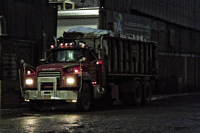
One of my practices, developed over the last decade or so, is to take a Newtown Creek break periodically and “allow my liver to return to a normal size.” I’m joking about the liver, but one does enjoy a bit of detox occasionally, and allowing the poisons I’ve accrued a chance to leach out. This is a luxury one enjoys, as he doesn’t live along Newtown Creek, others aren’t so lucky. Pictured above is roll on/ roll off garbage truck carrying a bin, spotted at a waste transfer station owned by a friend of mine which fairly straddles the border of Brooklyn and Queens.
– photo by Mitch Waxman
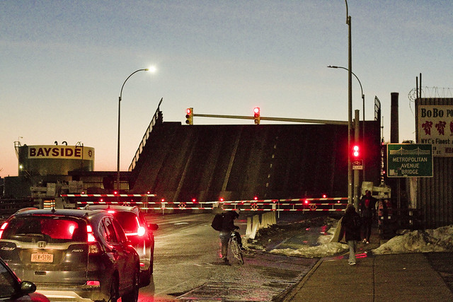
Marching along Metropolitan Avenue, one squealed with delight as the Metropolitan Avenue Bridge began to open. This used to be quite a frequent occurrence “back in the day.” These days there’s only one regular maritime customer back here on the English Kills tributary, which is Bayside Fuel.

– photo by Mitch Waxman
The timing of the bridge opening was bizarre, occurring at precisely the time of one of the heaviest traffic intervals in this section of North Brooklyn, about 6:30 p.m.

– photo by Mitch Waxman
That odd timing, however, allowed one to stand in the middle of Metropolitan Avenue without getting squished.

– photo by Mitch Waxman
I believe that the tug pictured above is the Mary H., which normally handles the Bayside duty, but it’s hard to say as I didn’t get any of its markings. I did manage to focus in on the captain in his wheelhouse, however, so “win.”
As a note, the Metropolitan Avenue Bridge spans the English Kills tributary of the larger Newtown Creek at a navigational mark 3.4 miles eastwards of the East River. Metropolitan Avenue was originally created as a private toll road about 1814, and was called the Williamsburgh and Jamaica Turnpike. The owners of the toll road, and the original bridge, were two brothers whose family name was Masters. That’s why you’ll occasionally see references to the road as the “Masters Turnpike” and the “Masters Bridge” in the historical record, if like me, you stay up until 4 in the morning reading old municipal journals and reports from the Chambers of Commerce of Brooklyn or Queens.

– photo by Mitch Waxman
My conceit is to call this area of Newtown Creek surrounding the Metropolitan Avenue Bridge “DUMABO.” That’s short for “Down Under the Metropolitan Avenue Bridge,” as I believe we need to be ahead of the real estate people on these sorts of things.
“follow” me on Twitter- @newtownpentacle
protecting shade

– photo by Mitch Waxman
Much to the chagrin of Our Lady of the Pentacle, an awful lot of time is devoted to “mah research”, and the recent largesse displayed by the NYC Municipal Records folks in allowing online access to their startling photographic collections has consumed an awful lot of my time.
Of particular interest to me, of course, are the historic shots of Newtown Creek and the surrounding communities at various moments in time. Today’s offering is a comparison of modern conditions with historic ones, which in the shots above and below- portray the venerable Grand Street Bridge in both eras from dissimilar but roughly analogous points of view.
My shot is closer to Queens, with the 1903 one below hugging the Bosserts lumber yard on the Brooklyn side.
Here’s the Grand Street bridge in 1903, when it was brand new courtesy NYC Dept. Of Records

Cool, huh?

– photo by Mitch Waxman
Metropolitan Avenue Bridge, formerly known as Masters Bridge, from English Kills looking west in modernity, and the precursor of the modern span being constructed in 1904 below (also looking west).
DUMABO in 1904, courtesy NYC Dept. Of Records

Also cool, no?

– photo by Mitch Waxman
Meeker Avenue Bridge is what it was called when it opened in 1939, and it was renamed as the Kosciuszko Bridge in 1940. My shot is from the middle of the Newtown Creek, while the historic view below is right next to the Phelps Dodge bulkheads on the Queens side.
Here’s the thing in 1939, courtesy NYC Dept. Of Records

– photo by Arthur J. Foley
____________________________________________________________________________
Click for details on Mitch Waxman’s
Upcoming walking and boat tours of Newtown Creek
July 8th, 2012- Atlas Obscura Walking Tour- The Insalubrious Valley
(note: there are just a few tickets left for this one)
for July 8th tickets, click here for the Atlas Obscura ticketing page
July 22nd, 2012- Working Harbor Committee Newtown Creek Boat Tour
![]()


