Posts Tagged ‘DUMABO’
northward pull
Wednesday, the dusk of the week.

– photo by Mitch Waxman
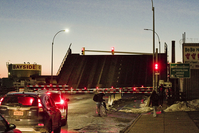
One can affirm that the Metropolitan Avenue Bridge is still there, as of last week. A small but double basculed draw bridge which spans the English Kills tributary of the fabled Newtown Creek, Metropolitan Avenue Bridge is 3.1 miles from the East River. You don’t see much in the way of maritime traffic back here, but there’s usually a tug and fuel barge found at the Bayside fuel depot’s bulkheads.
One would advise the curious that the shoreline is crumbling, and you want to be REALLY careful anywhere near the ragged edge of the land if you don’t want to end up immersed in Newtown Creek’s most polluted section. If you’re not being careful, the dice will roll and it’s either going to be X-Man or Liver Cancer for you.

– photo by Mitch Waxman
A couple of old fuel trucks are permanently stationed hereabouts, which endlessly fascinate me with their late 20th century design cues and onboard signage.
The burning thermonuclear eye of god itself was dipping behind Manhattan just as I arrived at the bridge, which served as my turnaround point on this particular walk. One does not decide in advance on where the pivot takes place, but it is often considered. That’s the thing about the street grid surrounding Newtown Creek – there’s so many dead ends and cul de sacs, which aren’t a big deal when you’re in a vehicle, but if on foot you need to factor them into your route.

– photo by Mitch Waxman
It was when I pivoted that the roar of powerful engines was heard. Frankly, I thought that a massive nocturnal bit of construction might be afoot due to the noise which was clearly audible even with my headphones in and Black Sabbath playing. It was approaching the sound levels encountered nearby the helicopter landing pads you encounter on the east side of Manhattan.
More on the tumult tomorrow.
Note: I’m writing this and several of the posts you’re going to see for the next week at the beginning of the week of Monday, September 28th. My plan is to continue doing my solo photo walks around LIC and the Newtown Creek in the dead of night as long as that’s feasible. If you continue to see regular updates here, that means everything is kosher as far as health and well being. If the blog stops updating, it means that things have gone badly for a humble narrator.
“follow” me on Twitter- @newtownpentacle
Buy a book!
“In the Shadows at Newtown Creek,” an 88 page softcover 8.5×11 magazine format photo book by Mitch Waxman, is now on sale at blurb.com for $30.
correlated causeways
Eleven bridges, one creek.

– photo by Mitch Waxman
Pulaski Bridge is the first span you encounter, when you’ve left the East River and embarked on a journey down the fabulous Newtown Creek. A double bascule drawbridge, and electrically powered, the Pulaski Bridge connects 11th street in Long Island City with McGuinness Blvd. to the south in Brooklyn’s Greenpoint. Built in 1954, the Pulaski Bridge is owned and operated by the New York City Department of Transportation or “NYC DOT.” The Pulaski Bridge carries five lanes of traffic, plus a dedicated bicycle lane and a separate pedestrian pathway. It overflies the Queens Midtown Tunnel and Long Island Expressway, as well as active railroad tracks found on Borden Avenue.

– photo by Mitch Waxman
DB Cabin acts as a gatekeeper to the Dutch Kills tributary of Newtown Creek. It’s a railroad swing bridge owned by the Long Island Railroad, and connects two rail yards – the Wheelspur Yard (to the west, or left in the shot above) and the Blissville Yard – across the water. Both rail yards and the bridge itself are part of the LIRR’s Lower Montauk tracks. DB Cabin dates back to the 1890’s and is in a terrible state of repair. The swing bridge’s motors are nonfunctional, which isolates the Dutch Kills tributary from maritime traffic, and from the rest of the Newtown Creek.

– photo by Mitch Waxman
Cabin M is just to the north of DB Cabin on Dutch Kills, and the single bascule drawbridge connects the Montauk Cutoff with the Blissville Yard mentioned above. The Montauk Cutoff is an elevated track which used to provide a connection between the LIRR’s Main Line tracks at the nearby Sunnyside Yards with the Lower Montauk tracks along the north (or Queens side) shoreline of Newtown Creek. The 2020 Capital Plan just released by the Long Island Railroad’s owner – The MTA – includes funding to demolish Cabin M.

– photo by Mitch Waxman
Borden Avenue Bridge is owned by the NYC DOT, and is one of just two retractile bridges in NYC (the other being the Carroll Street Bridge over the Gowanus Canal). Built in 1908 to replace an earlier wooden drawbridge (1868) at the intersection of Borden Avenue and Dutch Kills, Borden Avenue Bridge received extensive upgrades and structural repairs in 2010 and 2011, and had its electronic components destroyed by flooding during Hurricane Sandy. Another round of repairs and upgrades began in 2019, which included asbestos abatement work.

– photo by Mitch Waxman
The Long Island Expressway is 71 miles long, and is operationally managed in three sections. The Queens Midtown Expressway is how it’s owners, the New York State Department of Transportation, refer to the section found between the Queens Midtown Tunnel and Greenpoint Avenue in Long Island City. This section is elevated, rising to 106 feet above the waters of Dutch Kills. The LIE truss pictured above handles some 87.7 thousand daily vehicle trips, or 32 million annually, to and from Manhattan,
– photo by Mitch Waxman
Hunters Point Avenue Bridge is due north west of Borden Avenue Bridge and the LIE truss. It’s a single bascule drawbridge, owned by the NYC DOT. Replacing an earlier wooden draw bridge that was opened and closed by a donkey walking on a wheel, the Hunters Point Avenue Bridge was built in 1910. Back then, it was a double bascule bridge, but a rebuild in the 1980’s simplified the mechanism to a single bascule. The masonry of the bridge is original to the 1910 design.

– photo by Mitch Waxman
The Greenpoint Avenue Bridge is found some 1.37 miles from Newtown Creek’s intersection with the East River, and roughly a half mile from the mouth of Dutch Kills. It’s a double bascule bridge, built in 1987, and owned and operated by the NYC DOT. There have been many Greenpoint Avenue Bridges, dating back to the first one built by Greenpoint’s town father Neziah Bliss back in 1850, but that one was called the “Blissville Bridge.” The Greenpoint Avenue Bridge is a traffic machine, carrying 28.3 thousand vehicle trips a day, or about ten million a year. Most of that traffic takes the form of heavy trucking.

– photo by Mitch Waxman
The brand new Kosciuszko Bridge(s) replaced a 1939 vintage truss bridge that carried the Brooklyn Queens Expressway over Newtown Creek and are found some 2.1 miles from the East River. The NYS DOT is busy putting the finishing touches on the new cable stay bridge’s construction. In addition to the… ahem… high speed traffic lanes of the BQE, there is also a pedestrian and bicycle pathway found on the new Kosciuszko Bridge which connects 43rd street in Queens’s Sunnyside section with Meeker Avenue in Brooklyn’s Greenpoint.

– photo by Mitch Waxman
The Grand Street Bridge is a swing bridge connecting Maspeth’s Grand Avenue in Queens with East Williamsburg/Bushwick’s Grand Street in Brooklyn. 3.1 miles back from the East River, in a section of Newtown Creek once called “White’s Dock,” the NYC DOT have recently announced plans to replace this 1909 beauty – which is actually the third bridge to occupy this spot. Damage from Hurricane Sandy, and the narrow roadways with height restrictions that the bridge offers, have pretty much sealed its fate. It will be missed.
This is where the main spur of Newtown Creek ends, as a note. Directly east is a truncated tributary called the East Branch, and another tributary called English Kills makes a hard turn to the south just before you encounter Grand Street Bridge.

– photo by Mitch Waxman
Metropolitan Avenue Bridge is a double bascule drawbridge that crosses the English Kills tributary of Newtown Creek, and is owned by the NYC DOT. Metropolitan Avenue was originally built as a private toll road in 1813, and the first bridge here was a part of the “Williamsburg and Jamaica Turnpike.” The current Metropolitan Avenue Bridge was built in 1931, although it has received significant alterations in 1976, 1992, 2006, and again in 2015. The 2015 alterations?
You guessed it, Hurricane Sandy strikes again.

– photo by Mitch Waxman
Montrose Avenue Rail Bridge is the final crossing found over the waters of Newtown Creek and its tributaries. Some 3.7 miles back from the East River, it’s the property of the Long Island Railroad and used for freight service on their Bushwick Branch tracks. A truss bridge, or trestle if you must, my understanding of things are that whereas the trackway and parts of the rail bridge date back to approximately 1924… there has been quite a lot of work done on the thing which I have not been able to fully document so rather than fill in blanks with assumptions – I’m just going to say that I don’t know everything… yet.
It’s an active track, it should be mentioned.
“follow” me on Twitter- @newtownpentacle
Buy a book!
“In the Shadows at Newtown Creek,” an 88 page softcover 8.5×11 magazine format photo book by Mitch Waxman, is now on sale at blurb.com for $30.
formula filled
My creek also puts on a show when I’ve been away from her too long.
– photo by Mitch Waxman
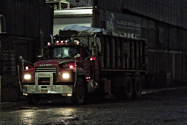
One of my practices, developed over the last decade or so, is to take a Newtown Creek break periodically and “allow my liver to return to a normal size.” I’m joking about the liver, but one does enjoy a bit of detox occasionally, and allowing the poisons I’ve accrued a chance to leach out. This is a luxury one enjoys, as he doesn’t live along Newtown Creek, others aren’t so lucky. Pictured above is roll on/ roll off garbage truck carrying a bin, spotted at a waste transfer station owned by a friend of mine which fairly straddles the border of Brooklyn and Queens.
– photo by Mitch Waxman
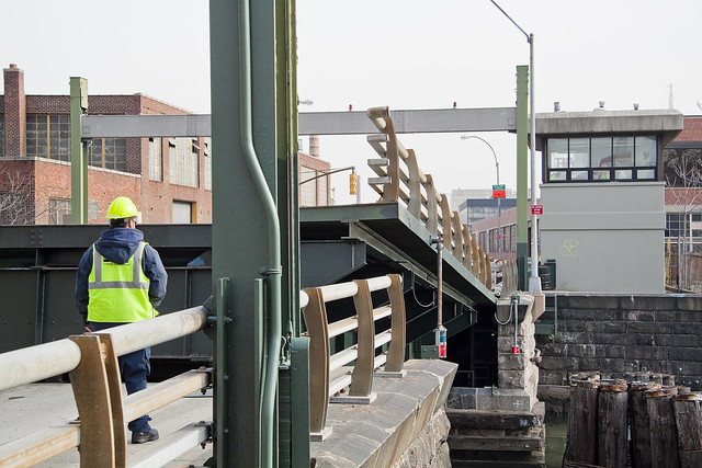
Marching along Metropolitan Avenue, one squealed with delight as the Metropolitan Avenue Bridge began to open. This used to be quite a frequent occurrence “back in the day.” These days there’s only one regular maritime customer back here on the English Kills tributary, which is Bayside Fuel.

– photo by Mitch Waxman
The timing of the bridge opening was bizarre, occurring at precisely the time of one of the heaviest traffic intervals in this section of North Brooklyn, about 6:30 p.m.

– photo by Mitch Waxman
That odd timing, however, allowed one to stand in the middle of Metropolitan Avenue without getting squished.

– photo by Mitch Waxman
I believe that the tug pictured above is the Mary H., which normally handles the Bayside duty, but it’s hard to say as I didn’t get any of its markings. I did manage to focus in on the captain in his wheelhouse, however, so “win.”
As a note, the Metropolitan Avenue Bridge spans the English Kills tributary of the larger Newtown Creek at a navigational mark 3.4 miles eastwards of the East River. Metropolitan Avenue was originally created as a private toll road about 1814, and was called the Williamsburgh and Jamaica Turnpike. The owners of the toll road, and the original bridge, were two brothers whose family name was Masters. That’s why you’ll occasionally see references to the road as the “Masters Turnpike” and the “Masters Bridge” in the historical record, if like me, you stay up until 4 in the morning reading old municipal journals and reports from the Chambers of Commerce of Brooklyn or Queens.

– photo by Mitch Waxman
My conceit is to call this area of Newtown Creek surrounding the Metropolitan Avenue Bridge “DUMABO.” That’s short for “Down Under the Metropolitan Avenue Bridge,” as I believe we need to be ahead of the real estate people on these sorts of things.
“follow” me on Twitter- @newtownpentacle
hidden laboratory
It’s International Cheese Day, for the industrialized and lactose tolerant nations of this planet.

– photo by Mitch Waxman
3.4 miles from the East River is a spot which one refers to as DUMABO – or Down Under the Metropolitan Avenue Bridge Onramp. The first bridge over the flowing waters of English Kills was erected here (slightly to the west, actually) in 1814 and was privately owned by the Masters brothers, so it was accordingly referred to as the “Masters Bridge.” Historic sources indicate this spot as being, during the colonial to civil war period, the demarcation point between salt and fresh water on the English Kills tributary of the fabulous Newtown Creek. Shellfish were described as being found in “great abundance.” It was once known as White’s Dock, for the vulgarly curious. The precursor of the modern day Metropolitan Avenue Bridge was built in the 1870’s, and the modern bridge (much altered) was erected in 1931.
The fresh water was being fed into English Kills by upland springs and streams in nearby Bushwick that flowed downhill into it, and by ground water entering it from the bottom. Back in 1814, Metropolitan Avenue was just a wooden plank toll road rising up from the swamps, and it was called the “Williamsburgh and Jamaica Turnpike road.” The springs and streams of Bushwick are what attracted beer breweries like the Ulmer people to a then German speaking rural neighborhood to ply their trade, but I digress. The fat renderers and acid factories began to show up in the 1830’s and 40’s around these parts, and notably – Peter Cooper’s “pestilential” glue factory, where Jello was invented, was just a few blocks away.

– photo by Mitch Waxman
NYC DOT has been doing a bunch of work at this spot recently, some sort of construction that they attached to the bridge itself. Unfortunately, they didn’t do anything about the loose soil on the shoreline, nor the decaying wooden bulkheads holding that shoreline in place. Of course, not many people come back here, but it would have been fairly easy to fall into English Kills given the rotting shoreline when the shot above was captured.

– photo by Mitch Waxman
That’s the Mary H. tug, tied up to the Bayside Fuel Depot bulkheads, just east of the Metropolitan Avenue Bridge. This is pretty much the extent of serious maritime access to English Kills given the black mayonnaise/sediment mound situation that gobbles up operational draught and depth. The green wall with all the kit on top is Waste Management’s Varick Street Waste Transfer Station. The Waste Management facility handles predominantly “putrescent” or black bag garbage for the NYC Department of Sanitation, which is processed on site and then loaded onto the so called “garbage train” which travels on the tracks of LIRR’s Bushwick Branch to Fresh Pond and then over the Hell Gate Bridge to points unknown.
Seriously, unknown. I’ve asked and was told “homeland security” precluded the dissemination of where NYC’s garbage is dumped.

– photo by Mitch Waxman
One headed up Varick Street towards industrial Bushwick from Metropolitan Avenue, where this spectacular salt dome structure was encountered. Seriously, no sarcasm is offered, this was a visually interesting and somewhat elegant solution to the problem. The rest of the neighborhood is dull, weathered, depressing. It’s nice to see a bit of color and style on display for something so pedestrian. It’s right next door to the Waste Management facility on Varick Avenue.

– photo by Mitch Waxman
The streets in this section, just south and east of Newtown Creek, are industrial in the extreme. Heavy trucking, the garbage industrial complex… suffice to say that the roadways aren’t exactly bike or pedestrian friendly, and that they are in a sorry state of repair. Watch your step hereabouts, and never cross in front of a driveway without first taking a look. This part of the Newtown Creek watershed is what the band Metallica was likely describing with their “death magnetic” album. There’s “ghost bikes” everywhere you look, the air is a poisonous fume…
Yep, it’s pretty much Tolkien’s Mordor back here.

– photo by Mitch Waxman
Turning off of Varick, I found myself wandering down Stewart Avenue and onto Randolph Street towards the undefended border of Brooklyn and Queens and that hazy industrial borderland which can either be called Ridgewood, East Williamsburg, or Bushwick – depending on whom you ask. Saying that, move quickly through this area, don’t talk to anyone, and certainly do not ask them questions if they speak to you. I would expand on why, but I’d again be told that I’ve seen too many movies, by some rich guy that moved to Hipster Bushwick from Connecticut less than six months ago who is trying to connect with a local art or club scene that they heard about on Instagram.
Of course, I couldn’t have more inconspicuous – the only person for about a square mile not wearing a safety vest and hard hat, and instead clad in a filthy black raincoat flapping about in the poison wind while waving a camera about.

– photo by Mitch Waxman
Speaking of the Bushwick Branch of the LIRR, which carries the garbage train from Bushwick into Queens and its mysterious destination on the continent, it’s just beyond that fence in the shot above. It’s been a while since I wandered through here, and those corrugated fences you see are fairly new, as evinced by a near total lack of graffiti. Back to the implied presence of criminally inclined individuals who are organized into a structure which one might define as a “crew” or a “family,” I’d point out the total lack of graffiti on a visible fence line in North Brooklyn – the high end graffiti capital of these United States.
Go ask someone who grew up in Brooklyn or Queens what that means.
Nevertheless, as is always the case when wandering through the industrial zones surrounding the fabled Newtown Creek, that horrible inhuman thing with the three loved burning eye that cannot possibly exist in the sapphire megalith of Long Island City was watching. It sees all, owns all, knows all.
More to come, next week, at this – your Newtown Pentacle.
“follow” me on Twitter- @newtownpentacle
tradition emphasizes
Creek week continues, in today’s post.

– photo by Mitch Waxman
As promised in yesterday’s post, a different perspective on the Creek is offered today. For the last few days, we’ve been on the DEP property in Greenpoint, and a birds eye perpective on DUGABO – Down Under the Greenpoint Avenue Bridge Onramp – was offered. In today’s post, the POV is from onboard a NY Water Taxi, and it’s the English Kills Tributary of the larger Newtown Creek.

– photo by Mitch Waxman
That’s the Metropolitan Avenue Bridge, as seen from the turning basin adjoining it, looking east towards Bushwick and East Williamsburg. I call this spot DUMABO – Down Under the Metropolitan Avenue Bridge Onramp. In colonial times, this was traditionally the demarcation point between fresh and brackish water on the Creek, but back then English Kills was fed by dozens of upland streams and springs. The water bubbling up out of the earth up on the hills of Ridgewood and Bushwick are part of what drew the Germans out here, and a lot of them – like the Ulmers – were involved in the beer business.
The beer guys, who do the holy work of delivering sacrament to bars and bodegas, are still in the area but there’s mainly micro brew hipster stuff going on these days and it’s fed by the DEP’s croton water system rather than ground water. The big guys like Budweiser – pictured above – ship their product in from elsewhere. There’s a pretty big beer distributor nearby on Grand Street, whose warehouse backs up on English Kills, and that Bud Light truck is likely heading there.

– photo by Mitch Waxman
Also on Brooklyn’s Grand Street is the former Charles J. King recycling company, which seems to have recently changed ownership. Luckily, the new owners continue to exploit their maritime bulkheads to ship their product out of the area, rather than truck it out. The sections of Brooklyn and Queens surrounding the eastern sector of the Newtown Creek have some of the highest concentrations of heavy truck traffic in the entire City of New York.

– photo by Mitch Waxman
That’s the NYC DOT’s Grand Street swing bridge in the shot above, a 1909 relic of the days when Tammany Hall came to Newtown Creek shortly after the consolidation of the City of Greater New York in 1898. It’s the titular ornamentation signifying the positioning of the currently undefended legal border of Brooklyn and Queens. On the Queens side of the bridge, Grand Street becomes Grand Avenue, which travels through Maspeth and several other communities. Despite a few interruptions in its path introduced by Robert Moses, Grand Avenue eventually enters Astoria and becomes 30th avenue which heads all the way down to the East River near Halletts Cove.
Of course – on the Brooklyn side – Grand Street more or less connects to the East River in Williamsburg.

– photo by Mitch Waxman
The Brooklyn side concrete company pictured above, called Empire Transit Mix, is sited on what was once called Furman Island. There used to be two islands found in the neighborhood of Maspeth Avenue, with the smaller one known as Mussel Island. Mussel was dredged away in the WW1 era, and its spoils were used to connect Furman Island to Brooklyn. This netted Brooklyn a bit of additional land mass and supposedly increased its legislative delegations by one seat.
Furman Island is the former home of Peter Cooper’s Glue Factory, Martin Kalbfleisch’s Acid and Chemical works, and Conrad Wissel’s Night Soil and Offal dock.

– photo by Mitch Waxman
The area where the Newtown Creek widens out is referred to as “the Turning Basin” and it’s where you’ll find the National Grid company’s LNG facility, which sits on a former Manufactured Gas Plant which was operated by the Brooklyn Union Gas Company. There’s a lake of coal tar under the National Grid property, and a wall of the stuff clinging to their property in the water.
As a note, I have made multiple attempts to formally visit the National Grid site, using institutional means. Polity and smarmy conviviality have been met with a brick wall of denial of entry. Every attempt to learn what goes on there has been met with obfuscation and a cry of “Homeland Security.” It’s a “no cameras” zone, National Grid says. It’s a “Marsec 1” zone, National Grid says.
It’s visible from above, via the Kosciuszcko Bridge, and from the water, and from the street sides – say I. I’ve got long zoom lenses, as well. I’ve also got access to documentation on the place via the environmental review process, State DEC oversight, and the Superfund investigations.
One wonders what they’re hiding back in there. I’ll find out over the course of time.

– photo by Mitch Waxman
Speaking of the Kosciuszcko Bridge, at the western end of the turning basin, you’ll find the 1939 span and the replacement span which the State DOT is currently working on.
These shots were captured just last week while onboard a pair of sold out Open House NY tours of the Newtown Creek which I conducted with my colleague T. Willis Elkins from Newtown Creek Alliance. My practice on these tours is to narrate the excursion – discussing the past – in from the East River to the Metropolitan Avenue Bridge, then hand the microphone over to Willis – who discusses the future.
While he’s talking, one grabs the camera and gets busy.
Upcoming Events and Tours
Sunday, August 14th, 11:00 p.m. – 1:00 p.m. –
Calvary Cemetery Walking Tour,
with Atlas Obscura. Click here for more details.
Sunday, August 21, 11:00 a.m. – 1:00 p.m. –
Poison Cauldron Walking Tour,
with Atlas Obscura. Click here for more details.
“follow” me on Twitter- @newtownpentacle


