Archive for the ‘Montrose Avenue Railroad Bridge’ Category
correlated causeways
Eleven bridges, one creek.

– photo by Mitch Waxman
Pulaski Bridge is the first span you encounter, when you’ve left the East River and embarked on a journey down the fabulous Newtown Creek. A double bascule drawbridge, and electrically powered, the Pulaski Bridge connects 11th street in Long Island City with McGuinness Blvd. to the south in Brooklyn’s Greenpoint. Built in 1954, the Pulaski Bridge is owned and operated by the New York City Department of Transportation or “NYC DOT.” The Pulaski Bridge carries five lanes of traffic, plus a dedicated bicycle lane and a separate pedestrian pathway. It overflies the Queens Midtown Tunnel and Long Island Expressway, as well as active railroad tracks found on Borden Avenue.

– photo by Mitch Waxman
DB Cabin acts as a gatekeeper to the Dutch Kills tributary of Newtown Creek. It’s a railroad swing bridge owned by the Long Island Railroad, and connects two rail yards – the Wheelspur Yard (to the west, or left in the shot above) and the Blissville Yard – across the water. Both rail yards and the bridge itself are part of the LIRR’s Lower Montauk tracks. DB Cabin dates back to the 1890’s and is in a terrible state of repair. The swing bridge’s motors are nonfunctional, which isolates the Dutch Kills tributary from maritime traffic, and from the rest of the Newtown Creek.

– photo by Mitch Waxman
Cabin M is just to the north of DB Cabin on Dutch Kills, and the single bascule drawbridge connects the Montauk Cutoff with the Blissville Yard mentioned above. The Montauk Cutoff is an elevated track which used to provide a connection between the LIRR’s Main Line tracks at the nearby Sunnyside Yards with the Lower Montauk tracks along the north (or Queens side) shoreline of Newtown Creek. The 2020 Capital Plan just released by the Long Island Railroad’s owner – The MTA – includes funding to demolish Cabin M.

– photo by Mitch Waxman
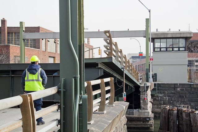
Borden Avenue Bridge is owned by the NYC DOT, and is one of just two retractile bridges in NYC (the other being the Carroll Street Bridge over the Gowanus Canal). Built in 1908 to replace an earlier wooden drawbridge (1868) at the intersection of Borden Avenue and Dutch Kills, Borden Avenue Bridge received extensive upgrades and structural repairs in 2010 and 2011, and had its electronic components destroyed by flooding during Hurricane Sandy. Another round of repairs and upgrades began in 2019, which included asbestos abatement work.

– photo by Mitch Waxman
The Long Island Expressway is 71 miles long, and is operationally managed in three sections. The Queens Midtown Expressway is how it’s owners, the New York State Department of Transportation, refer to the section found between the Queens Midtown Tunnel and Greenpoint Avenue in Long Island City. This section is elevated, rising to 106 feet above the waters of Dutch Kills. The LIE truss pictured above handles some 87.7 thousand daily vehicle trips, or 32 million annually, to and from Manhattan,
– photo by Mitch Waxman
Hunters Point Avenue Bridge is due north west of Borden Avenue Bridge and the LIE truss. It’s a single bascule drawbridge, owned by the NYC DOT. Replacing an earlier wooden draw bridge that was opened and closed by a donkey walking on a wheel, the Hunters Point Avenue Bridge was built in 1910. Back then, it was a double bascule bridge, but a rebuild in the 1980’s simplified the mechanism to a single bascule. The masonry of the bridge is original to the 1910 design.

– photo by Mitch Waxman
The Greenpoint Avenue Bridge is found some 1.37 miles from Newtown Creek’s intersection with the East River, and roughly a half mile from the mouth of Dutch Kills. It’s a double bascule bridge, built in 1987, and owned and operated by the NYC DOT. There have been many Greenpoint Avenue Bridges, dating back to the first one built by Greenpoint’s town father Neziah Bliss back in 1850, but that one was called the “Blissville Bridge.” The Greenpoint Avenue Bridge is a traffic machine, carrying 28.3 thousand vehicle trips a day, or about ten million a year. Most of that traffic takes the form of heavy trucking.

– photo by Mitch Waxman
The brand new Kosciuszko Bridge(s) replaced a 1939 vintage truss bridge that carried the Brooklyn Queens Expressway over Newtown Creek and are found some 2.1 miles from the East River. The NYS DOT is busy putting the finishing touches on the new cable stay bridge’s construction. In addition to the… ahem… high speed traffic lanes of the BQE, there is also a pedestrian and bicycle pathway found on the new Kosciuszko Bridge which connects 43rd street in Queens’s Sunnyside section with Meeker Avenue in Brooklyn’s Greenpoint.

– photo by Mitch Waxman
The Grand Street Bridge is a swing bridge connecting Maspeth’s Grand Avenue in Queens with East Williamsburg/Bushwick’s Grand Street in Brooklyn. 3.1 miles back from the East River, in a section of Newtown Creek once called “White’s Dock,” the NYC DOT have recently announced plans to replace this 1909 beauty – which is actually the third bridge to occupy this spot. Damage from Hurricane Sandy, and the narrow roadways with height restrictions that the bridge offers, have pretty much sealed its fate. It will be missed.
This is where the main spur of Newtown Creek ends, as a note. Directly east is a truncated tributary called the East Branch, and another tributary called English Kills makes a hard turn to the south just before you encounter Grand Street Bridge.

– photo by Mitch Waxman
Metropolitan Avenue Bridge is a double bascule drawbridge that crosses the English Kills tributary of Newtown Creek, and is owned by the NYC DOT. Metropolitan Avenue was originally built as a private toll road in 1813, and the first bridge here was a part of the “Williamsburg and Jamaica Turnpike.” The current Metropolitan Avenue Bridge was built in 1931, although it has received significant alterations in 1976, 1992, 2006, and again in 2015. The 2015 alterations?
You guessed it, Hurricane Sandy strikes again.

– photo by Mitch Waxman
Montrose Avenue Rail Bridge is the final crossing found over the waters of Newtown Creek and its tributaries. Some 3.7 miles back from the East River, it’s the property of the Long Island Railroad and used for freight service on their Bushwick Branch tracks. A truss bridge, or trestle if you must, my understanding of things are that whereas the trackway and parts of the rail bridge date back to approximately 1924… there has been quite a lot of work done on the thing which I have not been able to fully document so rather than fill in blanks with assumptions – I’m just going to say that I don’t know everything… yet.
It’s an active track, it should be mentioned.
“follow” me on Twitter- @newtownpentacle
Buy a book!
“In the Shadows at Newtown Creek,” an 88 page softcover 8.5×11 magazine format photo book by Mitch Waxman, is now on sale at blurb.com for $30.
shattered nerves
English Kills, at night.

– photo by Mitch Waxman
So this is where a humble narrator found himself last evening, but as I had good company with me, one was only mildly terrified by the solemnified majesty of Newtown Creek. This is near the end of all things, where Newtown Creek’s tributary English Kills flows into a sewer which also flows into English Kills. Dichotomies notwithstanding, that’s the Montrose Avenue Railroad Bridge in the left of the shot, which carries the tracks of the Long Island Railroad’s Bushwick Branch over the waterway, and into the luminance of Waste Management’s Varick Street location. It was windy.
This is Brooklyn, roughly 3.7 miles from the East River.

– photo by Mitch Waxman
There were rats.
As my pal Bernie Ente used to advise “the rats at Newtown Creek are well fed and won’t bother you, they don’t care that you’re there, but they might run over your feet.” That didn’t happen, foot wise, but my companion and I did spot a few plump specimens skittering between the shadows. The biggest issue encountered, actually, was when we followed a trod upon path around the borders of the canalized waterway. The brush is still thick, and there were a few fallen trees to contend with, but we were determined to gain access to the spot where the story of Newtown Creek suddenly stops.
That spot has a designation: NC-015.

– photo by Mitch Waxman
The mounds of litter and garbage that mix with and provide firmament to a tangle of self seeded vegetation and fallen trees can simply be described as “a trip hazard,” but there were more than a few spots encountered on the way to this location that could have easily ended with a broken ankle. It was quite dark, being night time, it should be mentioned. A portable light was used to illuminate the foreground in the shot above, but prior to that it was a silhouette against the water.
3.8 miles from the East River, the western facing point of view above is from above Combined Sewer Outfall #NC-015. It’s the 20th largest of the 400 such outfalls in NY Harbor, in terms of volume, releasing 344 million gallons of untreated wastewater into English Kills a year (last time I checked).
“follow” me on Twitter- @newtownpentacle
ignorantly spared
Back on the job.

– photo by Mitch Waxman
Since the recent extreme cold spell has broken, a humble narrator has found himself marching about again, and boy are my dogs barking. On Tuesday, a stroll over to Bushwick East Williamsburg was enacted and the farthest reaches of the Newtown Creek at English Kills were observed. As expected, the waterway was frozen over.

– photo by Mitch Waxman
Toxic ice. You don’t get to say that particular phrase that too often, but that’s what you’re looking at in the shot above. English Kills is the far eastern terminus of Newtown Creek, which branches off of the East River nearly 3.8 miles from the larger waterbody. These shots were gathered at about 3.7 miles back.

– photo by Mitch Waxman
That big sewer outfall at the end of the tributary is the 3.8 mile terminus mark, and the north/south street seen beyond the fencelines is Johnson Avenue. The surrounding neighborhood is gentrifying (dictionary definition of gentrifying), but on a fairly small scale as compared to points found to the west like LIC and Greenpoint.

– photo by Mitch Waxman
One decided to hang around the neighborhood for a bit and stretch my legs after the long interval of being trapped in the house by inclement clime, and visit a few of my favorite places. This shot is from the Scott Avenue footbridge, which spans the LIRR’s Bushwick Branch freight tracks, just as the burning thermonuclear eye of God itself was dipping behind New Jersey to the west.

– photo by Mitch Waxman
Heading over towards Metropolitan Avenue, and another of the dead end tributaries of Newtown Creek – the East Branch, one discovered that this section of the water was similarly locked in a decidedly polar state.

– photo by Mitch Waxman
The ice was decaying faster in both waterways where it touched the open sewer outfalls, no doubt due to the flow of melt water laden with road salt coming in from as far away as Canarsie. This untreated sewage is quite biologically active as well, and the metabolism of the microscopic entities contained in the water column likely helps to warm it up a bit.
“follow” me on Twitter- @newtownpentacle
quiet removal
It’s National Boston Creme Pie Day, in these United States.

– photo by Mitch Waxman
If you want to know what the end of the world looks like, I can take you there. It’s about 3.8 miles from the East River, in an area of Brooklyn that is clearly Bushwick but which the real estate people refer to as East Williamburg. The end of the world is surrounded by heavy industry and waste transfer stations, and is crossed by a railroad bridge. It’s defined by a waterbody called English Kills, which is a dead end tributary of the fabulous Newtown Creek.
Just last week, a visit was paid to this paradise of nihilism.

– photo by Mitch Waxman
The open sewers are just one of the apocalyptic factors back here, as is the enormous waste transfer station operated by a transnational conglomerate that handles about a third of the black bag (or putrescent) garbage collected by the Department of Sanitation. There is virtually zero laminar flow to the water here, which means that the rising and falling of the tide is a vertical affair rather than a horizontal one, creating stinking shoals along the banks and allowing sediment mounds to rise from the channel. It often smells like rubber cement thinner along this stretch of English Kills, the waters are greasy, and they commonly exhibit an uncommon and unnatural coloration highlighted by patches of weird iridescence.
Men and women seem to become possessed by the spirit of the place, wildly dumping garbage into the shallows with a gleeful abandon.

– photo by Mitch Waxman
References in the historical record refer to distinct periods in English Kills’ existential course. Once, a mostly fresh water stream fed by the springs and streams of a Bushwick that drew German beer Brewers to the area, which bled sweet water into the main body of Newtown Creek, just a decade after the American Civil War English Kills began to be described as the “industrial canals of Brooklyn.” By the time that the Army Corps of Engineers oversaw the WW1 era shaping of the Newtown Creek watershed into something we would recognize on a google map in modernity, English Kills had open pipes carrying industrial and chemical waste products into the water from acid factories and the other dirty industries surrounding it. The upland springs and steams which drew the brewers here were paved over or turned into sewers, and the only naturally occurring liquid entering the narrow channel afterwards was a tepid trickle of brackish East River water (which was itself terribly compromised) weakly pulsing in with the daily tide, or storm runoff from the streets.
Brooklyn legend suggests this area was used as a graveyard by mobsters, but that’s just a legend. Gangsters dump bodies into fast moving or oceanic water bodies like Jamaica Bay or the Hudson River. The idea is to get rid of the evidence, not to leave something incriminating in a place where it can be found.
Whatever enters English Kills stays in English Kills.

– photo by Mitch Waxman
The structure pictured above is the Montrose Avenue Railroad Bridge, part of the Bushwick Branch lead tracks of the Long Island Ralroad. The bridge, and adjacent fencelines, are covered in odd graffiti which is in English but drawn with characters that betray a runic influence. The screeds warn of witches and other mythological creatures.
This is what the end of the world looks like, if… like me… the borders of your world are defined and bisected by that lugubrious ribbon of urban neglect known as the Newtown Creek.
Upcoming Tours and events
Exploring Long Island City, from Luxury Waterfront to Abandoned Factories Walking Tour,
with NY Adventure Club – Sunday, November 12th, 2:30 p.m. – 4:30 p.m.
Long Island City is a tale of two cities; one filled with glittering water-front skyscrapers and manicured parks, and the other, a highly active ground transportation & distribution zone vital to the New York economy — which will prevail? With Newtown Creek Alliance Historian Mitch Waxman – details here.
“follow” me on Twitter- @newtownpentacle
perilous experiences
Shut your trap.

– photo by Mitch Waxman
2012 and 2013 seem to have been years wherein I spent more time in Greenpoint than I did in Queens, which is something that great efforts in the name of correction have been made in 2014. Lost in soliloquy and pondering the meaning of itself, North Brooklyn has plenty of folks watching over it, while Queens screams for attention and there seems to be only me paying it any mind. Spotted on Steinway Street in Astoria, this yellow horse offers vainglorious thrills, although it is a shadow of what is possible in the world of equestrian statuary.
I do not think that the apogee of horse sculptures will offer rides for 50 cents, however.
from wikipedia
The Genghis Khan Equestrian Statue, part of the Genghis Khan Statue Complex is a 40 metre (131 ft 3 in) tall statue of Genghis Khan on horseback, on the bank of the Tuul River at Tsonjin Boldog (54 km (33.55 mi) east of the Mongolian capital Ulaanbaatar), where according to legend, he found a golden whip. The statue is symbolically pointed east towards his birthplace.

– photo by Mitch Waxman
On Newtown Road in Astoria at its intersection with 41st street, one notices a rare artifact of an earlier age.
An uninterrupted block of Matthews Model Flats ends with a wrap around corner that hosts a commercial shop on the first floor. My network of Croatian informants tell me that they remember nothing about the storefront ever being anything other than what it is now, an electrician’s location, and one hopes that some Astorian reading this post can help fill the rest of us in on the past history of the spot.
from mas.org
The Mathews Model Flats were built by speculative developer Gustave X. Mathews and designed by Louis Allmendinger in the early part of the 20th Century. Considered to be some of the most innovative housing in the city, these “new law” tenements were designed with more space and better sanitation than their overcrowded 19th Century counterparts.

– photo by Mitch Waxman
Finally- a shot from Brooklyn’s Bushwick, or East Wiiliamsburg as the Real Estate people call it.
This is the dead bang end of Newtown Creek – actually, its tributary English Kills.
More and more of the people I encounter from this neighborhood are coming down here, seeking vicarious thrills and “disaster tourism.” Some are actually dragging boats and kayaks through the sediments to get into the water.
Lords and Ladies… English Kills is an open sewer, and one of the most polluted spots in New York City if not the planet. I know a whole lot about what’s going on back here and try to limit my exposure to this spot down to 3 or 4 times a year. There’s a reason that the Feds are going to spend hundreds of millions to clean things up. If you’re going to insist on boating in Newtown Creek, please launch from someplace safer. Please?
from habitatmap.org
People using the creek for recreational purposes such as swimming and boating may come into direct contact with chemical contaminants and harmful biological organisms. People may come in contact with contaminants present in the shallow creek sediments while entering or exiting the creek during recreational activities.
“follow” me on Twitter- @newtownpentacle
There are three Newtown Creek walking tours coming up.
Sunday, June 21st, America’s Workshop
A FREE tour, courtesy of Green Shores NYC, click here for rsvp info
Saturday, June 28th, The Poison Cauldron
With Atlas Obscura, click here for tickets and more info.
Sunday, June 29th, The Insalubrious Valley
With Brooklyn Brainery, lunch included, click here for tickets and more info.


