Archive for the ‘Manhattan Bridge’ Category
tag removed
Don’t go to Manhattan unless you have to, that’s what I say.

– photo by Mitch Waxman
Last week, one used his free time to visit a few spots in Lower Manhattan which offer a certain resonance to the historically minded traveler. A quick ferry trip from Greenpoint found me in the financial district, whereupon a looping path carried the camera through first Chatham Square and then over to Paradise Square – aka the former Five Points. It wasn’t a formal “lookee look” as I’ve done and written about that in the past, instead I just wanted to refresh the muscle memory of where a number of Jakob Riis’s photos were captured, and take a walk through one of the few sections of Manhattan that are still interesting.
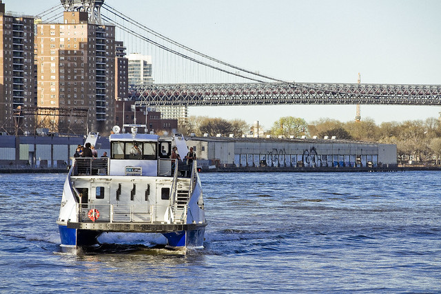
Also, I was craving Chinese Roast Pork Buns (Bao) and I know a great bakery in the shadow of the Manhattan Bridge near Eldridge Street. My old “go to” on Walker Street has changed management and no longer regularly produces the savory variant of Bao, and instead they focus on the manufacture of sickly sweet ones filled with custard – blech.

– photo by Mitch Waxman
There’s a pretty neat roughly two hour route around Lower Manhattan which I feel like I can hang my hat on, starting at the Pier 11 ferry stop at Wall Street. You walk north past Peck Slip and the Brooklyn Bridge, hanging a left a couple of blocks south of the Manhattan Bridge. That carries you through a set of new law tenements to the east side of Chinatown, where you can pick up Canal and make a left on Bowery towards modern day Confucius Plaza (Chatham Square) and then up Mott to the actual Five Points. From there, head west to Broadway and then South through Printers Square where all the courthouses are, then head to the Battery where you’ll find Castle Clinton and Pier A and then loop back again to the Ferry at Pier 11.
It’s a nice walk, lotsa history.
– photo by Mitch Waxman
One has been supernally busy for the last couple of weeks, which is not a complaint, and when a rare opportunity for some “me” time came up – I grabbed it by both horns. One has quite a few irons in the fire at the moment, planning events and tours for the summer months, and there’s also been a sudden deluge of meetings to attend regarding that fabulous cataract of urban malfeasance known as the Newtown Creek. It was nice to have an afternoon off which I could fill with some meandering.
NYC History notes for today include the anniversary of the 1936 opening of the Bronx Whitestone Bridge, which was actually yesterday, and today is the anniversary of the creation of the Port Authority of New York and New Jersey in 1921.
Upcoming Tours and Events
May 17th – Port Newark Boat Tour – with Working Harbor Committee.
For an exciting adventure, go behind the scenes of the bustling Port of NY & NJ on our Hidden Harbor Tour® of Port Newark! Get an insider’s view of the 3rd largest port in the nation, where container ships dock and unload their goods from around the world. See how the working harbor really works and learn about what all those ships and tugs do. See giant container terminals, oil docks, dry dock repair, and more!
Tickets and more details here.
“follow” me on Twitter- @newtownpentacle
rational position
I really need a vacation.

– photo by Mitch Waxman
Part of the fun involved with buying a new lens is testing it out. Doesn’t matter how good or bad the device is, there’s “sweet spots” and contradictory failings which the itinerant wanderer needs to be familiar with if the thing is part of the daily carry. The B&H folks have a fairly generous return and exchange policy, and in my experience, the window in which you can hand them back the lens is a crucial interval for the investment. Accordingly, one has been shooting everything, and everywhere.
I can tell you this, the sigma 50-100 is one hell of a portrait lens, but I’ve had unequal results in certain circumstances. My effort at the moment is to discover where and when those failings occur, rendering them predictable.

– photo by Mitch Waxman
One of the places this lens absolutely sings is in the dark. The shot above is “wide open” and was captured while I was waiting for the train at 59th street recently. I’ve been saying it for a while, but the subway system is an absolutely fantastic photography workshop. Worst case scenario lighting, with a reflective subject moving at speed through darkness.
I don’t often “open the hood” on the process I use to produce shots for Newtown Pentacle, but since a bunch of you asked after yesterday’s post…

– photo by Mitch Waxman
The shots above were captured at f2.2, with the lens dialed out to 94mm at ISO 5000. I’ve got a few other “bright lenses” but the sigma 50-100 really does a beautiful job drinking in the lurid shimmerings of pale light, and it literally outshines the other specimens in my “dark” kit. You can discern the lens’s aperture blades in the hot spots surrounding the R train’s headlights, incidentally.
Shots like these subway images are dependent, in my experience on shooting posture. There are US Army sniper rifle manuals out there which discuss shooting postures, and the body posture process which riflemen use to steady and focus their fire on targets is quite appropriate for the capture of light through a lens, IMHO.

– photo by Mitch Waxman
From a different commute, the shot above was captured at Queens Plaza, and also depicts an R line train entering the station. There’s a bright, almost cartoony quality to the way that sigma’s “art” series lenses renders primary colors which required some adjusting on the saturation slider when I was working on the shot in Photoshop’s “camera raw” window.
For those not in the know, RAW format is essentially an uncompressed digital negative which allows a great deal of fine tuning to the captured shot as the file contains ALL of the information which the sensor saw, whereas JPEG is an image which is compressed and all the decisions have been made for you by the camera. Those decisions include color temperature, depth of shadows/highlights and so on. Every RAW shot can therefore receive a bit of a tweak, and I always shoot in that format.

– photo by Mitch Waxman
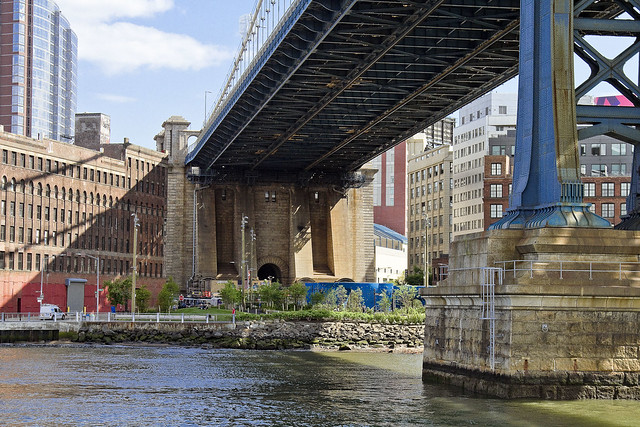
One of the things I engage in when testing a lens is trying to push it to fail. Architectural detail does not work well with a wide open lens, due to the shallow depth of field. Even an infinity focus will produce unacceptable “bokeh” in this context, or at least it’s unacceptable to my eye. I want to see every rivet.
Saying that, the two shots of the Manhattan Bridge in today’s post were shot at f2.2 on a sunny afternoon.
I think I’m going to keep this lens.
“follow” me on Twitter- @newtownpentacle
be ready
Green Acres, that’s the place for me?
– photo by Mitch Waxman
I grew up in a place called Brooklyn. I lived there nearly half my life, followed by a decade in Manhattan, and the most recent portion has been in Queens. Occasionally, I’ve visited… Staten Island… and the Bronx. The only time I’ve ever spent outside the City were a) day trips to various Aunts and Uncles who lived in New Jersey, Maryland, or Long Island when I was a kid, b) business trips around the Eastern Seaboard back when I was drawing comics, c) or on vacations with Our Lady of the Pentacle. When the news of the day reaches me, my first question always revolves around “how does this affect me?” This selfish interpretation of events makes me an archetypal New Yorker.
All told, I’ve probably spent all but an aggregate of maybe 3-4 months of my entire existence (nearly five decades now) outside of the Megalopolis. I always say that if I moved away, it would be ceding victory to the City that it had finally beaten the tar out of me.
I guess that makes me a “City Boy.”
– photo by Mitch Waxman
Personally, I’ve considered it a privilege to live my life at the very navel – the omphalos, if you will – of the American Civilization, but when I mention the fact that my experience in life is fairly well limited to the Megalopolis – a lot of people I mention this to get a sad or pitiful look in their eyes. My environmentalist buddies, in particular, will offer to take me camping or something with them so I can experience the wonders of untamed nature.
Blecchhh.
I went camping once, just once. I ended up sleeping in the car as it had doors which locked, it was dry, and there were cushioned seats. A day trip to the woods sounds like fun, but with a sunburn and mosquito bites, and the “Brooklyn” wiseass in me offers that I have an apartment with a bed in it. Like I said – City Boy.
– photo by Mitch Waxman
I’ve often reminded people that the ocean is a giant stomach desperate to digest you, that woodlands are full of ticks and bears and other critters which are specifically designed to overpower and consume you, that there’s a reason our ancestors paved over everything, and that the entire history of mankind – up until the 1970’s – was about not just taming nature but utterly subjugating it. Look at the shot above for confirmation of this fact, which is the epitome of what was once called “Progress.”
Now, I’m not saying that my antipathy towards clouds of biting insects and giant Pleistocene era predators is normal, nor necessarily desirable, nor something you should make a part of yourself. If you enjoy this sort of activity – Mazel Tov. I like hanging out in Astoria and nursing a pint at my local. What I’m trying to get to is this:
The littoral environment hereabouts is somehow recovering from the centuries long hammer blows of open sewage, ocean dumping of garbage, and industrial effluent which it was been hit with. The continued existence of our own species is directly tied to this recovery, IMHO, which is why this City Boy has found himself constantly talking about environmental issues. If we can’t control and promote environmental health in the built environment of NYC, where a switch or lever can be thrown to control nearly everything you can think of – where else can you figure out how to fix the future?
NYC has always led the Nation, it’s the bow of the American ship. We need to find out, together, how to be a mega city for plants and animals and humans and commerce and be the global example on the subject of clean water in an urban environment. The City boy has spoken.
Upcoming Events and Tours
Thursday, May 26th at 6 p.m. –
Brooklyn Waterfront: Past & Present Boat Tour,
with Working Harbor Committee. Click here for more details.
Saturday, June 4, 11:00 a.m. -1:30 p.m. –
DUPBO: Down Under the Pulaski Bridge Onramp,
with Brooklyn Brainery. Click here for more details.
“follow” me on Twitter- @newtownpentacle
nervous motion
Brooklyn, Manhattan, Williamsburg.

– photo by Mitch Waxman
As mentioned yesterday, one is taking a short break – hence the singular image which greets you above. Back soon with new stuff.
“follow” me on Twitter- @newtownpentacle
Upcoming Tours and events –
October 7th, 2015
Our Polluted History:
A Non-Toxic & Fascinating Forum on Greenpoint’s Environmental Past panel discussion
with GWAPP, click here for details
October 10th, 2015
Calvary Cemetery Walking Tour
with Atlas Obscura, click here for details and tickets
pale vapors
Lower Manhattan’s FDR drive, in today’s post.

– photo by Mitch Waxman
Just prior to this shot of Manhattan’s FDR Drive being captured, a humble narrator had walked across the East River via the Williamsburg Bridge from the border of Greenpoint and Williamsburg at Meeker Avenue. One enjoyed a brief sit down and contemplation of the past at Corlears Hook park on Cherry Street before continuing on. Cherry Street on the East Side is one of those spots in NYC which is writ large in the historic record, and even Jacob Riis mentions it (during its degenerate period).
According to contemporaneous reports, the absolute worst tenements of the 19th century were not found at the famous Five Points but here at Cherry street. Additionally, a gang whose specialty was river piracy operated out of this area – they were called the Swamp Angels – and it’s because of their infamy that the NYPD ultimately created the Harbor Unit. After resting for a few minutes (it’s important to give your lower back an interval of downtime on a long walk, since it’s actually doing most of the work) I crossed one of the pedestrian bridges over the coastal parkway and entered “The House of Moses.”
from wikipedia
In 1785, the four-story mansion at 3 Cherry Street was leased by the Continental Congress to serve as the Executive Mansion for Richard Henry Lee, President of the Congress under the Articles of Confederation. It continued to serve as such for the next three Presidents and, in April and May 1789 served as the first Executive Mansion of the President of the United States and Mrs. Martha Washington.

– photo by Mitch Waxman
Another term of my own invention, “The House of Moses” is appropriately used when you find yourself on Borden Avenue in LIC, or Meeker Avenue in Greenpoint, in certain parts of Astoria, or even here along the East River coast of the Shining City itself. Wherever NYC’s master builder Robert Moses felt it was appropriate to eliminate vast swaths of residential or industrial real estate in order to make way for a high speed road (distinguished by zero grade crossings, mind you), you’re in the “The House of Moses.”
from wikipedia
Robert Moses (December 18, 1888 – July 29, 1981) was the “master builder” of mid-20th century New York City, Long Island, Rockland County, and Westchester County, New York. As the shaper of a modern city, he is sometimes compared to Baron Haussmann of Second Empire Paris, and was arguably one of the most polarizing figures in the history of urban planning in the United States. His decisions favoring highways over public transit helped create the modern suburbs of Long Island and influenced a generation of engineers, architects, and urban planners who spread his philosophies across the nation. One of his major contributions to urban planning was New York’s large parkway network.

– photo by Mitch Waxman
“The House of Moses” had a tendency to blight the areas surrounding it. The sections of Sunset Park and Red Hook which the Gowanus Expressway casts its shadow upon have never truly recovered, for instance. For generations, this East River waterfront was generally verboten to residents of surrounding communities, due to stink and crime. For most of my lifetime, this area was a de facto parking lot for Municipal employees, and a homeless camp. Ummm, ok – it is STILL both of those things, but there’s a lot less of the foreboding and sense of imminent doom or threat of arrest than there used to be.
The same process played out along the Hudson, and is currently underway on the western coast of a Long Island – the so called Brooklyn and Queens Greenways. The modern motivation for improving these littoral areas is that parks aid real estate development, of course.
from wikipedia
The East River waterfront in Lower Manhattan was known for heavy maritime activity, with over 40 piers in operation by the later 1950s. The busy waterfront provided easy access to New York Harbor and the Atlantic Ocean in the south, the Hudson River on the west, with a connection to the Erie Canal. However, the rise of truck traffic and the transfer of port activity to the Port Newark-Elizabeth Marine Terminal drastically reduced maritime traffic on the river after the middle 20th century. With many piers now defunct, ambitious plans have been made to reclaim and reuse the pier space. The north-south arterial highway, the FDR Drive, was moved to an elevated location to allow convenient access to the piers. In the 1970s, the Water Street Access Plan was drafted to extend the confines of the traditional Financial District eastward and create a new business corridor along Water Street, south of Fulton Street. Noting the success of the World Financial Center, the East Side Landing plan was created in the 1980s to add commercial and office buildings along the waterfront, again south of Fulton Street, similar to Battery Park City. This plan never materialized.

– photo by Mitch Waxman
The process is quite far along in the tony sections of Brooklyn’s Gold Coast like DUMBO and Williamsburg, as well as in Hunters Point. The eventual goal on that side of the East River will be a contiguous pathway which will allow you to walk or ride a bike through a modern residential corridor extending from Red Hook all the way to Astoria Park with just a few interruptions offered by obstacles like the Brooklyn Navy Yard, and certain unpleasantries – such NYCHA housing projects or Newtown Creek.
On the Manhattan side, the river walk currently extends (contiguously, I mean, as it does travel quite far north with interruptions) from 23rd street all the way south to Wall Street in the financial district and connects into Battery Park nearby the Staten Island Ferry.
Saying that, some sections of the promenade seem better used than others.
from nyc.gov
The East River waterfront has developed over the past 350 years as a central place in the city’s maritime history. The city began here, and as it grew and developed, the island expanded into the river. As population expanded, the city promoted the infill of waterfront lots to serve the growing demand for land in Lower Manhattan. As a result, the current shoreline is more than three city blocks from the original shore. The present location of Pearl Street is in fact the original East River shoreline of Lower Manhattan. As the city’s position as the premier port for trade on the east coast grew, so did the need for new piers to service the vessels coming and going out of the port. At its peak in the 1950’s there were over 40 piers along this two-mile stretch of waterfront; today there are fewer than 10 remaining.
With the decline in maritime activity over the past 40 years, various master plans have been developed for this waterfront. The Water Street Access Plan in the 1970’s envisioned Water Street as a commercial spine for modern office buildings and the expansion of the financial core. In the 1980’s, the plan for East River Landing, inspired by Battery Park City, proposed new office development on the waterfront south of Fulton Street. In the 1990’s, a new outpost for the Guggenheim Museum was proposed on the waterfront at the present location of piers 13 and 14 at the foot of Wall Street. Aside from some components of the Water Street Access Plan, none of these waterfront schemes have been realized to date.

– photo by Mitch Waxman
Part of the planning and construction offered to the 20th century by the “House of Moses” included not just highways but block after block of “slum clearance” projects. Hundreds of acres of walk up tenement buildings were razed to make room for apartment houses whose footprint could encompass an entire city block, something you see a lot of in the eastern section of Chinatown. These apartment complexes were financed and built using Federal monies that filtered through carefully chosen banks and insurance companies. His allies in finance and government were fiercely loyal to Robert Moses and urban renewal was how he paid them back. Author Robert Caro called Moses “The Power Broker.”
It’s fantastic that those days are long over, and there isn’t some moneyed clique of real estate, insurance, and construction interests that colludes with Government officialdom to displace and eradicate whole waterfront neighborhoods. That would be awful, wouldn’t it?
from wikipedia
Caro’s depiction of Moses’s life gives him full credit for his early achievements, showing, for example, how he conceived and created Jones Beach and the New York State Park system, but also shows how Moses’s desire for power came to be more important to him than his earlier dreams. Indeed, he is blamed for having destroyed more than a score of neighborhoods, by building 13 expressways across New York City and by building large urban renewal projects with little regard for the urban fabric or for human scale. Yet the author is more neutral in his central premise: the city would have been a very different place—maybe better, maybe worse—if Robert Moses had never existed. Other U.S. cities were doing the same thing as New York in the 1940s, 1950s, and 1960s. Boston, San Francisco and Seattle, for instance, each built highways straight through their downtown areas. The New York City architectural intelligentsia of the 1940s and 1950s, who largely believed in such prophets of the automobile as Le Corbusier and Mies van der Rohe, had supported Moses. Many other cities, like Newark, Chicago and St. Louis, also built massive, unattractive public housing projects.

– photo by Mitch Waxman
It’s actually in Chinatown where you’ll notice how thoroughly a community can embrace one of these waterfront esplanades installed by the House of Moses. Unfortunately, there are no signs installed by the State DEC cautioning against regular consumption of East River fish and crabs, and not once did I notice a bit of signage from the City DEP advising of the presence of a combined sewer outfall. Those pipes you’ll notice traveling down the supports of the FDR drive drain the elevated highway and feed directly into the East River.
Any who, that’s the House of Moses for ya.
from wikipedia
Large scale urban renewal projects in the US started in the interwar period. Prototype urban renewal projects include the design and construction of Central Park in New York and the 1909 Plan for Chicago by Daniel Burnham. Similarly, the efforts of Jacob Riis in advocating for the demolition of degraded areas of New York in the late 19th century was also formative. The redevelopment of large sections of New York City and New York State by Robert Moses between the 1930s and the 1970s was a notable and prominent example of urban redevelopment. Moses directed the construction of new bridges, highways, housing projects, and public parks. Moses was a controversial figure, both for his single-minded zeal and for its impact on New York City.
“follow” me on Twitter- @newtownpentacle
Upcoming Tours –
September 3rd, 2015
Newtown Creek Boat Tour
with Open House NY, click here for details and tickets.
September 20th, 2015
Glittering Realms Walking Tour
with Brooklyn Brainery, click here for details and tickets


