he wishes
Friday
– photo by Mitch Waxman
A bit of personal news, firstly. On December 30th, a humble narrator began to notice his throat feeling a bit sore. On New Year’s Eve, a wicked ibuprofen proof headache set in, and on New Year’s Day I developed a low grade fever with hot and cold flashes accompanied by body aches and fatigue. Given that this more or less describes the way I felt after getting the Covid vaccine a few months prior, guess what? The good news is since I am full vaxxed, the entire experience only lasted about 36 hours, and I’m back to the fine fettle I normally enjoy. Our Lady of the Pentacle is feeling similar symptoms as you’re reading this, minus the fever.
It was pretty miserable, but I’m glad that say that the vaccine protected me from ending up in a hospital. Overall, I’d give Covid 3 of 4 stars for physical misery, were I leaving it a Yelp review. Compared with what people I know experienced in middle 2020, this was a cakewalk, and wasn’t even close to the sickest I’ve ever felt from a virus.
– photo by Mitch Waxman
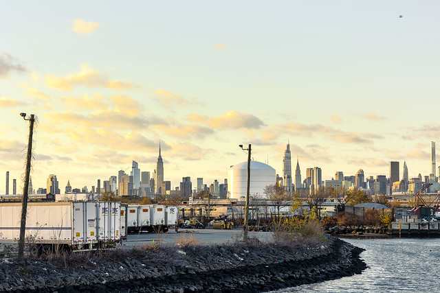
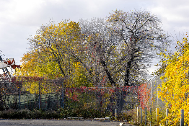
Saying all that, won’t be heading out for a walk again for a few days, despite desperately needing some outside time and exercise. Pictured above is one of the very few “independent” gas stations left in Western Queens. I’ve been making it a point of recording gas stations for a couple of years now. Gas Stations are targets for Big Real Estate because of the size of the lots they inhabit, and because the titans of affordable housing tax abatements know that they can get New York State to pay for the environmental cleanup of said lots under the “NYS Brownfield Opportunity Areas” program. Believe me when I tell you that the local political people aren’t going to be approving any new permits for such establishments anytime soon, because climate change and “Four wheels bad, two wheels good.”
This is Maspeth, in a legendary locale known only as Haberman.
– photo by Mitch Waxman
Oh, industrial Maspeth, the happy place, how I long for thee.
After shooting this photo, I boarded a rideshare taxi and headed home to Astoria. The shots above were captured after I had departed the company of that Grad Student whom I mentioned earlier in the week. Given that I had already scuttled around for about seven miles, I figured that a bit of comfort would be welcome. My driver told me about his theory that the last person legally elected President was Herbert Hoover. Under my mask, there was a big grin. My favorite conspiracy theories are the ones so grand in scope that they approach opera.
– photo by Mitch Waxman
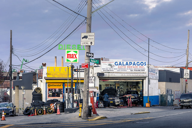
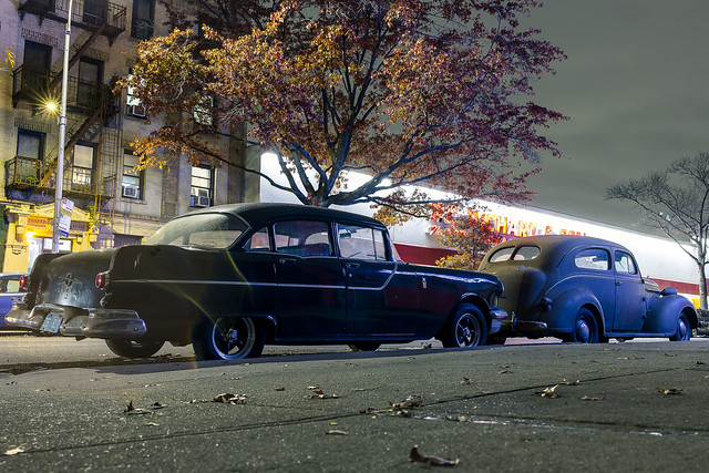
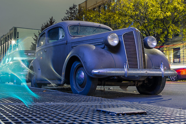
I was out the next night and shlepping down Steinway Street when I spotted a pair of atavist automobiles in front of a mechanic’s storefront. This was the first of several recent perambulations which I’ve described to Our Lady of the Pentacle as “local” and “not leaving the neighborhood.”
I’m trying to take more frequent walks these days, ones which are a bit shorter than walking home from the Brooklyn Navy Yard, in the name of burning off some of the pandemic blubber suit which I’m wearing. I’m not just overweight right now, I’ve gotten fat.
– photo by Mitch Waxman
The plan I’ve hatched is to jack up my metabolism a bit with a two pronged regime. First is to cycle in daily walks of no less than 90 minutes, with longer walks scheduled every three to four days. What that means, as an example, would be to walk from Astoria to Dutch Kills in LIC and back – roughly 4 subway stops each way – followed by a longer walk on the third day – industrial Maspeth or East Williamsburg or Flushing. The dailies build up my stamina and endurance, while the longer ones build muscle and eat up the adipose. The wild card is that trick left foot of mine.
Hopefully, by late spring or early summer I can begin to see “fighting weight” coming up in my rear view mirror.
– photo by Mitch Waxman
That green splotch on the left side of the shot is what happens when it starts to rain and a blob of water lands on the lens. There’s actually something I really like about the way that a distant traffic signal’s green light flowed into the droplet.
Back next week with some images from a newly instituted schedule of constant movement at this – your Newtown Pentacle.
“follow” me on Twitter- @newtownpentacle
Buy a book!
“In the Shadows at Newtown Creek,” an 88 page softcover 8.5×11 magazine format photo book by Mitch Waxman, is now on sale at blurb.com for $30.
he flees
Thursday

– photo by Mitch Waxman
On one of the very few public facing Newtown Creek walks of 2021, I was approached afterwards by one of the Gradate Students who had attended the thing. They asked me if I’d be willing to “show them the ropes” on the eastern side of Newtown Creek. This was before the current Pandemic surge condition set up, so I said “sure.”
I set a meet up point at 43rd street and Queens Blvd., but decided to take the train there from Astoria instead of the Q104 bus or just walking. M line to Jackson Heights, and transfer to the 7.
– photo by Mitch Waxman
A buddy of mine in Astoria gives me the “you’re crazy” face when I tell him to go this way, as he likes transferring to the 7 Line at Court Square. He’s wrong, as it’s three stops to Jackson Heights from my stop in Astoria and 4 stops to Court Square. Given that his route goes through Queens Plaza, it’s always going to take longer.
I’m smart… Smart, not dumb, not like people say.
– photo by Mitch Waxman
The particular path I took the grad student on involved some of the less visited spots along Newtown Creek like Maspeth Creek. As open sewers go, it’s a beauty.
Foliage, that’s what I kept on thinking. Foliage.
– photo by Mitch Waxman
Luckily, the pandemic has annihilated another Newtown Creek business, this one a distribution hub for an international bakery company that sells snack cakes. Accordingly, open fences, and an opportunity to get a shot that I’ve never gathered before.
Funnily enough, some of my Newtown Creek people – who always tell me that I’ve seen too many movies – recently discovered that the Mafia are still active in the Maspeth area. Surprising, huh? Beverage and snack food distribution using fleets of trucks to deliver to all cash businesses like Bodegas… who would associate the Mafia with that… I mean, it’s not like you grew up in New England and I grew up in 1980’s Flatbush and Canarsie. Thereby, your point of view on this topic is superior to mine. Saying that, I had a neighbor whose car horn literally played “The Godfather”’s theme music.

– photo by Mitch Waxman
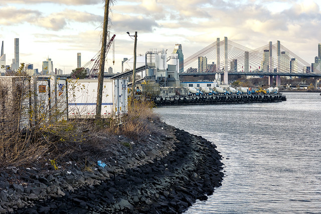
Around the end of our walk, I asked the Grad Student where they wanted to be for sunset, which was greeted with a shrug. I suggested the Grand Street Bridge, and the view you see above.
This shot is from early December, which ended up being a pretty productive month for a humble narrator. The reason I’m embedding six shots in the posts at the moment is to try and catch up with the actual calendar.
– photo by Mitch Waxman
Technically, this shot was captured in Brooklyn. The actual dividing line between the boroughs is more or less the dead bang center of the Grand Street Bridge.
More tomorrow.
“follow” me on Twitter- @newtownpentacle
Buy a book!
“In the Shadows at Newtown Creek,” an 88 page softcover 8.5×11 magazine format photo book by Mitch Waxman, is now on sale at blurb.com for $30.
he seeks
Wednesday

– photo by Mitch Waxman
The last stop on my early morning walk from the Brooklyn Navy Yard to Astoria… well, I didn’t make it to Astoria on foot since my left one was screaming with arthritic pain by this point… was the Meeker Avenue Street End site in Greenpoint. This used to be the Brooklyn side mooring of the Penny Bridge, replaced in 1939 by the “New Penny Bridge” which was renamed as the Kosciuszcko Bridge in 1940 and has since been replaced by the modern day Kosciuszcko Bridge seen above. I cannot count how many times I’ve had to make all of those connections to explain Penny Bridge over the years.
In every post describing every step of the way, I’ve mentioned the constancy of needing to find a place to pee or poop. Why? Well, in the midst of all the high fallutin political movements here in the City that never sleeps, one of the things that we continually ignore is basic human biology. You can decarcerate, you can include, you can… but you can’t work out how to create public bathrooms. The City has a hundred billion dollar budget and there’s no way to solve this.

– photo by Mitch Waxman
During non pandemic times, the “NYC system” revolved around walking into a diner or fast food joint and ordering something cheap off the menu – like a coffee – and then asking if the facilities are available. That’s what’s known as “passing a problem off to the private sector.” We do a lot of that here in NYC. The political estate mandates stuff all the time, and then hopes that the private sector can work out the details. It’s a big part of the pandemic issue right now. Vaccine requirements are meant to be enforced by bars and restaurants, but there’s no clear set of regulations for them to follow, nor is there a clear set of instructions for what to do if somebody refuses to cooperate other than summoning the cops to come and do their usual wrecking ball “overt display of authority” thing. It’s dopey.
My understanding is that NYPD’s morale is at the lowest it’s been since the late 1980’s. Telling people what to do is different than convincing them to do what’s best for everyone. It’s not a Cop’s job to do the latter, it’s a politician’s. Our Politicians all want to be superstars, and spend most of their time coming up with new laws rather than finding ways to make the old ones work better, and expect the cops to enforce whatever the hell it is they just came up with. Also, our laws never get retired, despite irrelevancy or ineffectiveness. You still can’t keep a goat, ferret, or chicken in your apartment for instance, and the NYC Anti Mask mandate of 1845 is still on the books. It’s illegal to wear a mask in public in several regions of the United States, which was a 1960’s statutory response to the Ku Klux Klan. The NYC version was installed to keep landlords from sending masked gangs into tenement buildings to keep their tenants in line.

– photo by Mitch Waxman
The Politicians rattle on about climate issues, but the vast majority of the so called affordable housing built under the recent regime, in the last decade, is rated “D” or worse by the City’s Department of Buildings on energy efficiency. Fossil fuel companies are the culprits, they say, and not the political campaigns which take election year contributions from National Grid and a host of other “energy and job providers.” What is the “super power” of a City Council member? It’s called ULURP, for NYC’S “Uniform Land Use Review Procedure,” which effectively gives an office holder the power to shape development in their district. ULURP power is also held by the Borough Presidents, and City Hall. You need Council, BP, and Mayor’s offices to sign off on this process. The latter can overwrite what the former opposes, but that’s a whole other story which involves pecking order and rank.
Let’s say that you’re a City Council Member – would you demand that new construction in your district include real estate investment that has environmental benefit and green space? Playgrounds? Transit contributions? Or – would you just let the same players who have been raping the urban environment and exploiting the political system’s vanity your whole life sidle up to the trough for another rich meal? Tenants don’t write checks during election campaign season, after all, landlords do.

– photo by Mitch Waxman
The mantra… Nothing matters and nobody cares…
There’s a situation at another section of the fabulous Newtown Creek, one in Long Island City, which grows increasingly perilous. A collapsing shoreline and tidal action which is clearly undermining a well travelled street that’s within a stone’s throw of LaGuardia Community College and several charter schools. Reporting the situation to the relevant agency was the most depressing experience I had in 2021, and given what the rest of that cursed year was like… The agency essentially said that they wouldn’t even inspect the situation since they looked at it three years ago when a different section of the shoreline collapsed.
Now, if a thumb tack was found in a bike lane – they’d call the FBI – but… Bah.

– photo by Mitch Waxman
A few people on the Twitter have asked me why I keep on rattling on about bike lanes, which is a program and network expansion thereof that I’m generally very much in support of. Here’s the thing – bike lane support doesn’t make you an environmental crusader – and support for a network of protected pathways for non automotive traffic to flow through isn’t a substitute for talking about the frankly existential storm water issue, and about legitimate and actual open soil green space. The actual implementation of most of these bike lanes has been piss poor – painting the gutter green, and surrounding it with plastic sticks about 30% of the way isn’t sufficient. You need actual physical separation, as in concrete barriers, not paint and plastic sticks. You also need to install a fourth lens on traffic signals, which will allow bikes an extra thirty to forty five seconds to cross and clear intersections before vehicular traffic gets the go ahead. Other cities with fewer resources have managed this.
If I’m wrong, then why did the Vision Zero years see traffic related fatalities go up instead of down? I swear, if anyone brings up Amsterdam to me again… Amsterdam has a population of just under 900,000 living in the central city, and about 2.5 million in its “greater metropolitan” area. The latter number is about how many people live just in the Borough of Queens. When a City agency tells you why they can’t do something it’s “because of scale,” but then they bring up freaking Amsterdam as an example of what’s possible. This is New York City, we don’t follow trends, we set them.

– photo by Mitch Waxman
See that leaking fire hydrant? I’ve watched it leak for about 15 years. It’s been reported to the City hundreds of times. The water it oozes carries street garbage to a nearby sewer grate which empties directly into Newtown Creek. The garbage causes the grate to become clogged, which creates a garbage pond. The pond, in turn, slowly empties into Newtown Creek carrying trash along with the flow. The last time that I managed to get the drain cleared, you want to know who I called to bring in a work crew? ExxonMobil. They operate some of their pumping equipment nearby, for the oil spill cleanup operation, and when I mentioned the “optics” of this to one of their principals, it was handled quickly and they used heavy equipment to scoop away the garbage pond’s embankments. Saying that, it was about four or five years ago. The hydrant continues to leak, and the pond grows. Someday, there’s going to be a waterbody called “Lake Meeker” here. Will that qualify as green space, or parkland?
Nothing matters, and nobody cares.
“follow” me on Twitter- @newtownpentacle
Buy a book!
“In the Shadows at Newtown Creek,” an 88 page softcover 8.5×11 magazine format photo book by Mitch Waxman, is now on sale at blurb.com for $30.
he screams
Tuesday

– photo by Mitch Waxman
That’s the Kosciuszcko Bridge, crossing my beloved Newtown Creek, pictured above. One had scuttled here from the Brooklyn Navy Yard along Meeker Avenue, and since my trick left foot was acting up, I decided that this would be an excellent place to chill out for a bit. As mentioned yesterday, a bathroom break was also required. There’s usually an unlocked Porta Potty down here, so that was my first destination in and area I call DUKBO – Down Under the Kosciuszcko Bridge Onramp (the Porta Potty was a great experience, I gave it a three out of four stars Yelp review).
I set up the camera on the tripod and got busy, afterwards. Of course, I could have gotten away with just doing hand held shots here, as it wasn’t even close to noon o’clock yet. Saying that, I wanted to “slow things down” a bit and attached a filter to my lens to cut down on the amount of light entering it. Smooth out some of the distracting texture and reflection in the water, all that.

– photo by Mitch Waxman
One finds its fascinating, actually. When you’ve got the shutter open for 10-30 seconds, you can begin to visualize the currents in the water column. See how, and where, the flow goes, y’know’s?
My pals at Newtown Creek Alliance shake their heads “no” at me when I describe my desire to release hundreds of thousands of rubber duckies into Newtown Creek, just to see where they go and illustrate how the currents work. Something about “micro plastic” and illegal dumping pretty much describes their objections. They also don’t like my plan to seed pumpkins and or carnivorous plants into the shorelines in Maspeth. No fun.

– photo by Mitch Waxman
You’ll notice structures like the one pictured above all over the harbor, and their purpose is to provide protection for shoreline features from passing maritime traffic. Called “dolphins,” they’re generally a bunch of wooden piles held together with galvanized steel rope. This is one of the ones which protect the piers of the Kosciuszcko Bridge, but it’s obviously associated with the 1939 version, rather than the newer one that’s currently extant.
The wood is likely creosote treated, which is why it hasn’t rotted away. Creosote is a chemical treatment for wood – usually coal tar creosote or petroleum creosote in a setting like this- which involves placing wood in a vacuum chamber to rid it of any water in the wood’s cellular matrix and then after introducing the creosote into the chamber, reversing the pressure to several atmospheres to force the creosote into the wood’s cellular lattice. This effectively makes the wood a hostile environment for micro and macro organisms. This process is used for railroad sleeper ties, dolphins, piers, utility poles and a host of other applications. Creosote is also a major component of a substance sold as a food flavoring additive called “Liquid Smoke.”

– photo by Mitch Waxman
Over on the Queens side of my beloved Newtown Creek, that’s the former site of the Penny Bridge. It’s also formerly a Long Island Railroad Lower Montauk line station called “Penny Bridge.”
Just to recap my day to this point, I left HQ in Astoria at about 4:30 in the morning and made it over to the NYC Ferry dock at Hallets Cove. From there, I captured shots for a photo assignment at the Brooklyn Navy Yard and then walked along and under the BQE through Brooklyn to this spot at Newtown Creek. The shot above was captured at about 10:30 in the morning on November the 21st, so I’d been “at it” for quite a while at this point.

– photo by Mitch Waxman
I’d ingested a meal along the way, a standard NYC egg sandwich and a container of orange juice which I grabbed at some deli in Williamsburg. Saying that, I had become fairly dehydrated by this point and was regretting my normal prohibition against carrying bottles of fluid. This habit of mine, which is prosaic as I’m literally carrying high capacity batteries and electronic devices all around my person, has bit me in the ass several times recently. Have to work out a way to get around my physical needs, I always think.
Between my sweatshirt – which hosts 22 distinct and secure pockets – my usual pants – which have 13 pockets – and the filthy black overcoat with its two pockets, and the ubiquitous camera bag(s) – I’ve got to figure out some spot where I can secret away a pint of water. Of course, then you have to pee again, so it’s a recursive feedback loop.

– photo by Mitch Waxman
I made one more stop after this, and then abandoned the entire idea of walking the rest of the way home due to the operatic condition offered by the trick left foot which I’ve been complaining about for what feels like years now. Internal dialogue wise, I refer to my feet as “the roadway interface” and having a full 50% of this apparatus malfunctioning has become a bit more than an annoyance. It’s slowing a humble narrator down, damnit.
More tomorrow.
“follow” me on Twitter- @newtownpentacle
Buy a book!
“In the Shadows at Newtown Creek,” an 88 page softcover 8.5×11 magazine format photo book by Mitch Waxman, is now on sale at blurb.com for $30.
he shuns
Monday

– photo by Mitch Waxman
As described, last year, a humble narrator’s perambulatory pursuits found him shambling eastwards on Brooklyn’s Meeker Avenue from the Brooklyn Navy Yard towards Astoria in Queens. My route was entirely encapsulated by the miles long steel and concrete pergola formed by the elevated roadway of the Brooklyn Queens Expressway. There has always been a population that dwells in this corridor – unfortunates and inebriates who set up camp sites constructed from tarps, cardboard, and shipping palettes – but during the pandemic months their numbers have exploded.
Empathy for their plight and situation would be expressed if I was still capable of experiencing emotions. Instead, one has become not unlike a stick of wood – dry, unyielding, uncaring, ready to burst into flame at the first hint of a spark. I’m intolerant of nonsense now, and it’s nonsensical that the greatest City in history cannot do anything about this situation other than build luxury condominiums in Manhattan’s Soho… but, alas, my new motto still applies – “Nothing matters and nobody cares.”

– photo by Mitch Waxman
This section of Brooklyn was once where the political boundary between Bushwick and Greenpoint was drawn, back when your electeds were called “Alderman” or “Ward Boss.” That’s before Robert Moses arrived on the scene in the late 1920’s. Moses was quite keen on something he referred to as “The Brooklyn Queens Connecting Highway” and after his ribald success in building both Mighty Triborough and the Grand Central Parkway, the Federal Government agreed to fund his ideation. Moses made the case that the multitudes of Brooklyn would choke local street traffic as they made their way to his 1939 World’s Fair in Flushing, and that a high volume/speed road was required.
Moses showed a certain predilection for building his projects right on the border between two political districts. The highway above required the whole scale demolition of a city block wide corridor, and thousands of homes and businesses were eradicated to clear the space. I’d imagine having two politicians feeding at his trough rather than one made the disruption to the locals easier to handle.

– photo by Mitch Waxman
The modern day Brooklyn Queens Expressway was christened in the post WW2 Urban Renewal era. The original road was a highway, which means a high speed road with frequent exit and entrance ramps and in places – bike and pedestrian paths – but when it became an expressway it lost several of those ramps and any thought of pedestrian access was removed. Parkway (planted shoulders), highway (high speed), throughway (no exits except at start and end), expressway (limited exits). These are all self explanatory terms, Moses would tell you, before offering analogies about breaking eggs and omelettes. The usage for the space below the elevated truss road was meant to saturate parking availability, but as you can see – “world longest homeless camp” is largely how it’s being used today.
The Brooklyn Queens Connecting highway, or at least the sections of it north of the Williamsburg Bridge leading into Queens, opened for business during the month of August in 1939. August 23rd, to be exact.

– photo by Mitch Waxman
One is supposed to be empathic towards those who dwell below. That’s virtue signaling horse shit, however. Nobody cares, nothing matters, and these people will be taken care of when the politicians and the crooks who buzz around them like shit flies figure out a way to make political capital and money off of the situation. Personally, everytime I buy a new bag of socks, the older ones get washed and thrown in a shopping bag which I leave nearby similar campsites, or are handed off to one of the many people I encounter in Queens who are living rough. I’m one bad month away from being in this situation myself, and my resources are best analogized as “not enough butter spread over too much bread.”
Life is cheap in the big city, but living costs a fortune.

– photo by Mitch Waxman
By this stage of the walk back to HQ in Astoria, one was beginning to experience fatigue. The trick left foot was singing an opera, and since my left leg was dragging a bit due to the foot, that caused a cramp to set up in my back. NYC doesn’t acknowledge human biology and thereby a series of urine splotches marked my northward progress. I also had to poop, but I’m not that far gone yet. I’ll gladly slip between two parked cars and piss into a sewer grate, but dropping a deuce in the open air isn’t a line I cross.
Also, what if somebody saw it? That’s how you end up on Instagram. “Hey, check out Mitch from Newtown Creek Alliance, he’s shitting in the street now.” Clearly, this signals that their entire thing is a corrupt eidolon offered up by real estate interests and morally bankrupt politicians. Told you he’s no good. I have a friend who advocates for bike lanes and safer streets, and he got photographed jaywalking and that spawned several days of commentary, for instance.

– photo by Mitch Waxman
My destination in this section of Brooklyn was ultimately the Kosciuszcko Bridge, which would carry me into Queens. There’s a neat bit of public space under the new bridge, where – coincidentally – I know there would a “Porta Potty” where I could solve my alimentary issues in private. Along the way, a park bench of two offered some relief for the operatic conditions being offered by the left foot.
More pedantic adventures tomorrow, at this, your Newtown Pentacle.
“follow” me on Twitter- @newtownpentacle
Buy a book!
“In the Shadows at Newtown Creek,” an 88 page softcover 8.5×11 magazine format photo book by Mitch Waxman, is now on sale at blurb.com for $30.


