Archive for the ‘Brooklyn Queens Expressway’ Category
he shuns
Monday

– photo by Mitch Waxman
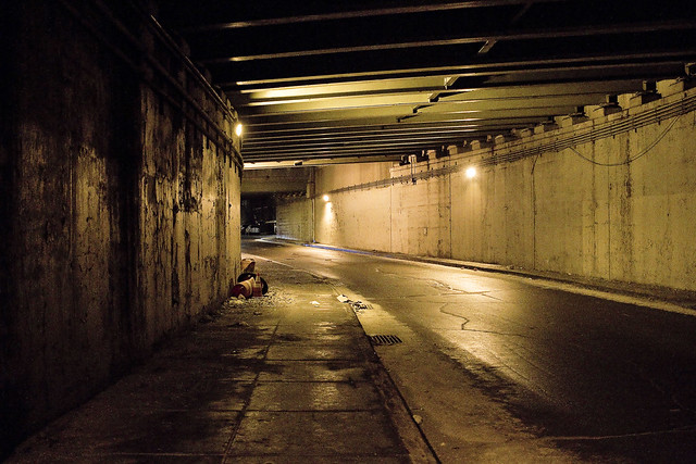
As described, last year, a humble narrator’s perambulatory pursuits found him shambling eastwards on Brooklyn’s Meeker Avenue from the Brooklyn Navy Yard towards Astoria in Queens. My route was entirely encapsulated by the miles long steel and concrete pergola formed by the elevated roadway of the Brooklyn Queens Expressway. There has always been a population that dwells in this corridor – unfortunates and inebriates who set up camp sites constructed from tarps, cardboard, and shipping palettes – but during the pandemic months their numbers have exploded.
Empathy for their plight and situation would be expressed if I was still capable of experiencing emotions. Instead, one has become not unlike a stick of wood – dry, unyielding, uncaring, ready to burst into flame at the first hint of a spark. I’m intolerant of nonsense now, and it’s nonsensical that the greatest City in history cannot do anything about this situation other than build luxury condominiums in Manhattan’s Soho… but, alas, my new motto still applies – “Nothing matters and nobody cares.”

– photo by Mitch Waxman
This section of Brooklyn was once where the political boundary between Bushwick and Greenpoint was drawn, back when your electeds were called “Alderman” or “Ward Boss.” That’s before Robert Moses arrived on the scene in the late 1920’s. Moses was quite keen on something he referred to as “The Brooklyn Queens Connecting Highway” and after his ribald success in building both Mighty Triborough and the Grand Central Parkway, the Federal Government agreed to fund his ideation. Moses made the case that the multitudes of Brooklyn would choke local street traffic as they made their way to his 1939 World’s Fair in Flushing, and that a high volume/speed road was required.
Moses showed a certain predilection for building his projects right on the border between two political districts. The highway above required the whole scale demolition of a city block wide corridor, and thousands of homes and businesses were eradicated to clear the space. I’d imagine having two politicians feeding at his trough rather than one made the disruption to the locals easier to handle.

– photo by Mitch Waxman
The modern day Brooklyn Queens Expressway was christened in the post WW2 Urban Renewal era. The original road was a highway, which means a high speed road with frequent exit and entrance ramps and in places – bike and pedestrian paths – but when it became an expressway it lost several of those ramps and any thought of pedestrian access was removed. Parkway (planted shoulders), highway (high speed), throughway (no exits except at start and end), expressway (limited exits). These are all self explanatory terms, Moses would tell you, before offering analogies about breaking eggs and omelettes. The usage for the space below the elevated truss road was meant to saturate parking availability, but as you can see – “world longest homeless camp” is largely how it’s being used today.
The Brooklyn Queens Connecting highway, or at least the sections of it north of the Williamsburg Bridge leading into Queens, opened for business during the month of August in 1939. August 23rd, to be exact.

– photo by Mitch Waxman
One is supposed to be empathic towards those who dwell below. That’s virtue signaling horse shit, however. Nobody cares, nothing matters, and these people will be taken care of when the politicians and the crooks who buzz around them like shit flies figure out a way to make political capital and money off of the situation. Personally, everytime I buy a new bag of socks, the older ones get washed and thrown in a shopping bag which I leave nearby similar campsites, or are handed off to one of the many people I encounter in Queens who are living rough. I’m one bad month away from being in this situation myself, and my resources are best analogized as “not enough butter spread over too much bread.”
Life is cheap in the big city, but living costs a fortune.

– photo by Mitch Waxman
By this stage of the walk back to HQ in Astoria, one was beginning to experience fatigue. The trick left foot was singing an opera, and since my left leg was dragging a bit due to the foot, that caused a cramp to set up in my back. NYC doesn’t acknowledge human biology and thereby a series of urine splotches marked my northward progress. I also had to poop, but I’m not that far gone yet. I’ll gladly slip between two parked cars and piss into a sewer grate, but dropping a deuce in the open air isn’t a line I cross.
Also, what if somebody saw it? That’s how you end up on Instagram. “Hey, check out Mitch from Newtown Creek Alliance, he’s shitting in the street now.” Clearly, this signals that their entire thing is a corrupt eidolon offered up by real estate interests and morally bankrupt politicians. Told you he’s no good. I have a friend who advocates for bike lanes and safer streets, and he got photographed jaywalking and that spawned several days of commentary, for instance.

– photo by Mitch Waxman
My destination in this section of Brooklyn was ultimately the Kosciuszcko Bridge, which would carry me into Queens. There’s a neat bit of public space under the new bridge, where – coincidentally – I know there would a “Porta Potty” where I could solve my alimentary issues in private. Along the way, a park bench of two offered some relief for the operatic conditions being offered by the left foot.
More pedantic adventures tomorrow, at this, your Newtown Pentacle.
“follow” me on Twitter- @newtownpentacle
Buy a book!
“In the Shadows at Newtown Creek,” an 88 page softcover 8.5×11 magazine format photo book by Mitch Waxman, is now on sale at blurb.com for $30.
grisly claws
Thursday

– photo by Mitch Waxman
It’s not like this in other cities. Not even Philadelphia. After having ridden on the NYC Ferry from Astoria to the Brooklyn Navy Yard, a humble narrator began a long scuttle northwards back towards Queens. One followed the Brooklyn Queens Expressway, and used its shadowed under vaults to escape the deleterious brightness of the burning thermonuclear eye of god itself. Shadow and filth.
This is a horrific corridor, as a note. Abandoned cars, mystery trucks without license plates, camp sites. Above are legions of fowl, and splattered below is their collective foul. Garbage turns in wind driven vortexes, stagnant pools glimmer with slime, the residue of spent petroleum coats everything in soot. The very air you breathe is a poisonous fume.

– photo by Mitch Waxman
This is figuratively the sort of New York City which Jakob Riis wrote about, where the toll of political corruption is writ large. This is literally the New York City spoken of by Robert Caro, and since 1939 this has been the House of Moses. Robert Moses, that is.
Hey… wait a second… did you notice… I was almost starting to care again. Woah. Glad I caught myself. “Nothing matters and nobody cares… Nothing matters and nobody cares… Nothing matters and nobody cares.”

– photo by Mitch Waxman
Don’t believe me that “Nothing matters and nobody cares”? Just look at that one above, Bro.
There’s a runoff pipe from the BQE, positioned right over a sewer grate that empties into the East River without ever entering a sewer plant first. It’s packed in with garbage, in one of the few open parking spots, where any random person can park a panel truck without license plates indefinitely. Think that nobody who works for the City or State has spotted this? Worried about “homeland security concerns” the way they would under the FDR Drive? Answer is yes, but it doesn’t matter to them and they don’t actually care.
Hey, do you know who the current President of the Borough of Brooklyn is? Do you suppose this sort of scene matters to him, and whether or not he cares about it? Within the next 48 hours, he’s got a new first name – Mayor.
“follow” me on Twitter- @newtownpentacle
Buy a book!
“In the Shadows at Newtown Creek,” an 88 page softcover 8.5×11 magazine format photo book by Mitch Waxman, is now on sale at blurb.com for $30.
gathered here
Mitch Waxman, working for YOU!

– photo by Mitch Waxman
The pathway which will allow access to the bike and pedestrian lane of the new Kosciuszcko Bridge is pictured above, a terrifying “last mile” section which is owned by the City. This is the approach at “Queens Midtown Expressway” or “Borden Avenue” (depending on whose map it is) which you get to via a southward journey along 43rd street in Sunnyside. It’s also the onramp for the BQE, and there’s nothing separating you from traffic other than a three inch curb. If you’re wondering, this is actually a fairly well used foot path between industrial Maspeth and South Sunnyside – so it’s not just me.
Why do I go this particular way? I’ll show you at the end of the post.

– photo by Mitch Waxman
Inviting, ain’t it?
A humble narrator is ringing the alarm bells here for a fairly simple reason, the Kosciuszcko Bridge construction project is meant to be opening the second and final half of the project up to traffic (of all kinds) by the end of the summer, at the latest. The City, which is supposed to have been redesigning this section of things (they own it), hasn’t been shown to have started any risible progress yet. Supposedly NYC DOT has a design, but where is it? Shovels in the ground, boys?
I’d be happy with a bunch of jersey barriers, truth be told.

– photo by Mitch Waxman
For years, literally years, I’ve been keeping an eye on this one.
I cannot tell you how many times in Western Queens that I’ve had the sudden realization that the sidewalk I was scuttling on led onto a highway. One time, after leaving St. Michael’s cemetery, the section of Astoria Blvd. I was walking along suddenly became the shoulder lane of the Grand Central Parkway as the sidewalk just ended.
– photo by Mitch Waxman
This path leads to a pedestrian bridge, one that the K Bridge project has recently constructed as a replacement for a far older but similar lane. Friends who grew up on the southern flank of Sunnyside tell me that this path was well familiar to them growing up, and that the road and sidewalk conditions found in the shot above date back to their earliest recollection.

– photo by Mitch Waxman
Just last week, I was walking through here and spotted the condition above. Hadn’t been through in about a month, so it’s possible this collapsed in sewer grate had been lying in wait for an errant tire to enter it for weeks.
Here’s the “working for you part.”

– photo by Mitch Waxman
First things first, you document it. That’s me and the camera in the shadow on the left. Second, you report it.
Now, here’s the thing… I often have trouble making 311 or 911 operators understand that Queens has hyphenated addresses. Also, it took several paragraphs of text and a few photos to describe the location and condition of this place to you, my quite savvy and well traveled Lords and Ladies of the Pentacle. Additionally, this was a dangerous situation and I feared somebody could be seriously hurt if their tire entered the hole.
Prior experience with road condition and damaged sewer hatch reporting (yep, lots and lots of prior experience) has taught me that it can take weeks for the City to dispatch somebody to do repairs. They’ll send the cops out to throw down a traffic cone, but otherwise – weeks. I’m “Mitch Waxman” however, so a quick scan of the contact list on my phone allowed me to contact the K Bridge team’s Community Liason’s office, who in turn alerted the NYC DEP, whose sewer it is. DEP dispatched an emergency squad within the hour and they had the thing all fixed and repaired by the next morning. On the repair front, I let my pals at Jimmy Van Bramer’s office know about all the goings on and how great I thought it was how the K Bridge team and DEP handled the situation. That was also in the name of “reporting it” since JVB’s office keeps a list of complaints and problems in his District and since this one wouldn’t come to them via 311 or 911, there you are.
Nobody gets hurt. Street boo boo all better now.

– photo by Mitch Waxman
On the other side of the “last mile” path, there is a permanently installed concrete separation between you and the onramp of the BQE. Where it slopes down and ends is the demarcation point of NYC and NYS’s property lines, or so I’m told. Want to guess why they’re there?
Yeah, that was me, suggesting it to the Engineering Team at K Bridge sometime back in 2012 or 2013.

– photo by Mitch Waxman
My pal “Special” Ed once described his ideal job title as “freelance unsolicited criticism,” which would take the form of waking into a bank and decrying the arrangement of the padded ropes leading to the tellers, whereupon he would then hand them a bill for his services. I don’t charge, but I fear that I’m living out Ed’s dream. Ed used to live downstairs from me in an apartment building on Manhattan’s Upper West Side, one which was packed with high school and college friends. We lived a life disturbingly reminiscent of “Seinfeld,” I’m afraid. Ed had nothing in his refrigerator save for a single glass of water and a spoon, and stored his clothing in the kitchen cabinets. I miss Ed.
Pictured above is the K Bridge from that pedestrian ramp dealie which carries you over the onramps to it from the LIE onto Laurel Hill Blvd. at the border of Maspeth and Blissville, and between the Kosciuszcko Bridge and First Calvary Cemetery.

– photo by Mitch Waxman
This is why I go this particular way. The view.
Just imagine what treasures await, when the ped and bike path is open. That’s presuming you don’t get squished by traffic on your way here, and end up in there.
“follow” me on Twitter- @newtownpentacle
vital change
DUKBO, in today’s all ‘effed up post.

– photo by Mitch Waxman
Before you ask, no, I didn’t get any shots of the Astoria Borealis. I was too busy running around HQ and unplugging all my gear. Not my first Con Ed rodeo here in Astoria, and experience has expensively taught me to unplug the gear when weird electrical things are occurring. Now, back to…
Laurel Hill Blvd. used to be the legal border between Maspeth and Long Island City, and in those halcyon days before NYC consolidation, nobody used the term “Queens.” They sort of made that one up in 1898, the Tammany boys did. This “angle” between neighborhoods is often visited by a humble narrator, and given the deserted and lonely condition of the place it’s where one such as myself belongs. I shouldn’t be around people, preferring as I do the darkness found amongst these places of abandonment, broken pavement, and poisoned soil.
At this particular moment, still reeling from all the smiling and comraderie of the holiday season, one is not unlike a regularly beaten animal – vicious and ready to bite.

– photo by Mitch Waxman
Whilst hanging about the fencelines of a cemetery at night, as one does, I was busy mentally considering my “book of rules,” specifically the section that discusses the verbalization or offering of threats. My “book of rules” is a codified series of truisms which I’ve created or collected for myself over the years. Every man should have a code, I believe. Mine includes “say what you do and do what you say,” amongst others, but in the case of the “threats” subsection of the larger “aggressive behavior” chapter heading I’ve been thinking about adding a few things lately. There’s a couple I’ve picked up from others like Nietzche’s “regret is like chewing on a stone and has the same result” or Shaka Zulu’s “never leave an enemy alive or he will rise again to strike at your throat.” Mainly, these revisions to the code revolve around, and advise, specificity. There’s a whole section on “That’s how they getcha” which advises against ordering pasta as a main course in restaurants, but that’s a different story.
On the threat front, it’s far more effective – in my experience – to offer “I’m going to take your eyes” or “I’m going to break your arm, the left one, above the elbow” than more generalized statements revolving around the kicking or punching of the various sections of an enemy’s anatomy. Also, “I’m going to end you” is just way, way too vague.

– photo by Mitch Waxman
When I’m out at night taking photos of junkyards and construction sites, one is attempting to use every watt of brain energy he’s got, which isn’t much so I have to ration. In addition to watching out for the approach of vehicular traffic or malign examples of the local population, and avoiding obstacles or pitfalls in my path, as I’m composing photos and operating the camera, there’s generally an audiobook or podcast playing through my headphones. In another layer of thought, I’m engaging in an inner dialogue which focuses on times I’ve been wronged without redress (the shot above involved reliving the time in Third Grade that Karen Yee told the teacher that I’d kicked her on the stairs while our class was going down to assembly. I was innocent then, and now, and Karen Yee can burn in the hell of liars). Yet another layer is constantly revising the codification of the “Book of Rules” which, as mentioned above, revolve around several topics. “Don’t eat shellfish at the start of a vacation,” for instance.
Also, I had to pee.
“follow” me on Twitter- @newtownpentacle
frenzied letter
My beloved Creek.

– photo by Mitch Waxman
An interesting thing about night time tripod based photos, which take fairly long intervals to capture, is that you become quite familiar with traffic patterns on area bridges. One was out fairly late on a Sunday night recently, shooting from the Greenpoint Avenue Bridge, and attempting to execute the shot above in between traffic light signal rotations. Finding a twenty five second interval, even forty minutes after midnight on a Sunday night, in which a heavy truck or MTA Bus is not crossing the Greenpoint Avenue Bridge and causing it to shake, vibrate, or heave… is a challenge.
There were about six shots on my camera card previous to the one above which were ruined by the sudden appearance of a speeding garbage truck, bus, or oil delivery semi and their somewhat seismic effect on the bridge. Such is life, I suppose.

– photo by Mitch Waxman
Things were a bit quieter back on Greenpoint’s Apollo Street, the titular epicenter and official discovery point of the Greenpoint Oil Spill. Once upon a time, this was the dividing point between two of Standard Oil’s refinery facilities (both of which later became a part of Mobil), but today it’s just a wasted little street end defined by a former BP Amoco and now Kinder Morgan petroleum distribution tank farm. The eastern side of the street is owned by the Manhattan/Empire Beverage Distribution company, a warehouse based operation that accomplishes the holy task of stocking NYC’s bars and liquor stores with product.
I’ve never met the Empire Beverage people, but I’d personally like to thank them for facilitating my life long love of degeneracy and for several besotted episodes of happiness that have punctuated my otherwise miserable existence.

– photo by Mitch Waxman
Funnily enough, at night, the sections of the Newtown Creek industrial zone where you’d expect things to be buzzing 24 hours a day are rather quite peaceful. It’s basically you and hundreds of feral kitties back here. There are weird moving shadows you’ll spot out of the corner of your eye snaking along the rooftops, which are often accompanied by a chittering sound that I do not like, but the less said about that the better.
There are some things you do not want to say too much, or know anything about, quite frankly.
“follow” me on Twitter- @newtownpentacle


