Posts Tagged ‘queens’
suggesting question
Canada Goslings in industrial Maspeth.

– photo by Mitch Waxman
Marching about recently, my path carried the camera past Maspeth Creek, which – as the name would imply – is in industrial Maspeth and is in fact a tributary of that lugubrious cataract of cautionary tales known to all simply as the “Newtown Creek.” Whilst scuttling past the Maspeth Creek waterway’s head waters, which flow out a sewer, these Canadian invaders were shifting from foot to foot in a manner which I did not like.
Geese, in general, are dicks. Canada Geese, in particular, are jerks as well as dicks.

– photo by Mitch Waxman
The good news, for this dick specie, is that there’s now more of them. “Goslings” are what you call baby geese. While I was shooting this, one of the adults – I’m presuming it was the papa – was ambling towards me while sticking his tongue out. I once had to punch a goose in the face at one of the area cemeteries to ward off an attack. This particular paragon of poultry was intent on killing me for wandering too close to a nest, I guess. For you PETA types out there, one tried every other recourse first including “flight” before “fight” became my only option. That “sumbitch” chased me half way across Calvary Cemetery before I had to vigorously assert my right to be unmolested with a closed fist.
Seriously, Geese are mean dicks, but they’re real cute when they’re babies.

– photo by Mitch Waxman
The one who was messing with me the other day is the big one, at the back of the group in the shot above. I’m not sure if Maspeth Creek is in the 108th or the 104th precinct, but if anyone recognizes that goose I’d appreciate it if you called the NYPD tips line and let them know. I bet that its name is Claude or Jean or something… pfft… Canada.
Back in conventional reality, rather than within my inner dialogue about rude avian biota, the Canada Goose is one of the many, many birds that arrive at Newtown Creek each and year.

– photo by Mitch Waxman
Newtown Creek, and all of NY Harbor, sits in the migratory Atlantic Flyover zone. Every year you get to see nestlings putting on weight and size all summer long around the creek. Towards mid August and late September, they’ll begin vacating the area for parts unknown, returning in late March and April.
There’s a bunch of them wallowing around in the toxic sediments of Maspeth Creek, in the shot above.

– photo by Mitch Waxman
Most of what I look out for as a hazard around the Newtown Creek are trucks rather than birds, and while making my way home, one marveled at all the different kinds. Semis, packers, roll on and roll offs, panel, box, wreckers, concrete… I even saw a couple of crane trucks. Industrial Maspeth is lousy with that sort of thing. There’s trains, too.

– photo by Mitch Waxman
Leaving the Maspeth area via 48th street, you cross under and over the Long Island Expressway while heading north into Sunnyside. I like to use this steel and concrete landmark, a corridor of the House of Moses, to mentally signal that I’ve left the Creeklands and reentered the world as it’s meant to be.
As in, if an aggressive goose showed his face around south Sunnyside, he’d soon find himself cooked.
Upcoming Tours and Events
June 22nd – The Birthplace of Mobil Oil: A Walking Tour
– with Newtown Creek Alliance.
Join NCA historian Mitch Waxman and NCA’s project manager Willis Elkins for walk through the birthplace of Mobil Oil, past the DEP’s largest Wastewater Treatment Plant and to the Kingsland Wildflowers green roof. The tour will also visit NCA’s Living Dock on the way; showcasing restoration efforts adjacent to major industrial operations and in the wake of legacies of pollution and neglect.
The tour will end at the 22,000 square foot Kingsland Wildflowers project, with panoramic views of the Newtown Creek and Manhattan skyline at sunset.
Tickets and more details here.
June 30th – The Skillman Avenue Corridor
– with Access Queens.
Starting at the 7 train on Roosevelt Avenue, we will explore this thriving residential and busy commercial thoroughfare, discussing the issues affecting its present and future. Access Queens, 7 Train Blues, Sunnyside Chamber of Commerce, and Newtown Creek Alliance members will be your guides for this roughly two mile walk.
Skillman Avenue begins at the border of residential Sunnyside and Woodside, and ends in Long Island City at 49th avenue, following the southern border of the Sunnyside Yards for much of its path. Once known as Meadow Street, this colonial era thoroughfare transitions from the community of Sunnyside to the post industrial devastations of LIC and the Dutch Kills tributary of Newtown Creek.
Tickets and more details here.
“follow” me on Twitter- @newtownpentacle
palpably diabolic
Being stressed out is a crutch, yo.

– photo by Mitch Waxman
One was scuttling along on a recent afternoon, marveling at the wonders of Queens. My day’s photographic targets having been captured, and fully entranced by one of my favorite HP Lovecraft audiobooks (The Horror at Red Hook, read by Wayne June), the path I was on had been chosen to get me home to Astoria from Newtown Creek as quickly as possible via 39th street in Sunnyside. There’s bunches of lovely residences along this stretch, but my visual instinct is generally unexcited by homes and gardens. Nevertheless, the camera is always ready to click and whirr should something interesting pop up.
I am, it should be mentioned, fascinated by the concrete clad topography of Western Queens. The “lay of the land” as it were. There’s all sorts of elluvial hillocks and ridges hidden beneath all the asphalt and brick, and when you walk these streets a lot, you can easily discern where water once flowed or pooled prior to the massive land reclamation and drainage projects of the early 20th century. These projects, and the concombinant political corruption involved with the execution of them, ended the careers of several of the early Borough Presidents of Queens in court.

– photo by Mitch Waxman
File the shot above under “you don’t see that every day,” and even for a humble narrator who has become jaded by the wonders of municipal industry, it isn’t every day that you see a heavy tow truck clad in FDNY trade dress towing an ambulance. I’m sure that the combination was ultimately heading for Maspeth, where the Fire Department maintains a couple of vehicle maintenance facilities.
After capturing the shot, I offered the driver a friendly wave of the hand. He smiled and waved back. Only employees of the FDNY seem to do this, amongst all the City agencies. Cops and Sanitation workers just kind of glare at me. I figure anything that a City employee is driving is partially owned by me anyway, so click and whirr.

– photo by Mitch Waxman
The shot above is from a different afternoon, the day that the Bicycle Fanatics came to Sunnyside to stage a protest. I took a bunch of shots of their “human protected bike lane” hooey, but do not wish to inflate their egos or cause any further than necessary. Accordingly, the crepuscular rays dancing about the Sapphire megalith and the ominous mestastase of the LIC skyline are presented instead.
“follow” me on Twitter- @newtownpentacle
muttered formulae
Deadman’s curve and the Pratt Oil Works, in today’s post.

– photo by Mitch Waxman
Normally, one would not be seen marching along the LIRR tracks in Blissville, but I had my reasons. It was a Sunday afternoon, anyway, meaning that the chances of there being any rail traffic at all on the Lower Montauk would be slim to none so I decided that it would be a good time to throw the dice and hope that I wouldn’t get squished by a passing locomotive. There’s plenty of places to dive out of the way, if I were able to discern an approaching train, but that’s kind of the issue – trains move pretty quickly and the physics of how sound moves around the air dam created by the engine as it’s moving seriously reduce the “early warning” time. Saying all that, I didn’t get squished, but do not recommend you chance it yourself. It is illegal trespass, after all.
Me, I was scoping out the latest wrinkle in the environmental story around the fabled Newtown Creek.

– photo by Mitch Waxman
I went to a meeting a couple of weeks ago at the NYS DEC offices in Long Island City, which discussed the “Pratt Oil Works Site” or as I’ve been referring to it for several years – “The Queens County Oil Works of Charles Pratt” or alternatively “The Blissville Seep.” ExxonMobil has taken responsibility for the site, which ultimately used to belong to its corporate parent Standard Oil, and has (under DEC guidance) begun the process of siphoning “product” out of the ground. Said product, the ExxonMobil folks said, is distinct from the liquid product which has been oozing from the Creek side bulkheads into the water. The modern day owner of the site is largely the Waste Management company, which operates a waste transfer station along Railroad Avenue that handles DSNY collections and loads up the Garbage Train. Said garbage train provides framing in the shot above. The Queens County Oil Works was in operation from 1842-1949, whereupon the property was subdivided and sold off. ExxonMobil representatives described the materials their contractor Roux will siphoning out of the ground as “Lube Oil and wax” and the petroleum product oozing into the Creek as “LNAPL” or Light Non-Aqueous Phase Liquid. LNAPL is lighter than water and floats on top of ground water.
ExxonMobil’s contractors, Roux Associates, who handle the Greenpoint Oil Spill for them directly across the Newtown Creek in Greenpoint, has been activated to handle the Blissville situation. Roux has installed 62 wells on the property, 42 of which are recovery wells and the other 20 are monitoring wells. Waste Management, separately, has several issues they’re dealing with on the site, including a high level of acidity in the soil and the presence of toxic chemicals – specifically Toluene and Chlorinated Volatile Organic Compounds. Waste Management will be aerosolizing these chemicals, meaning that they will be using a process called “SPARGing” which will release them into the open air.

– photo by Mitch Waxman
ExxonMobil representatives were cagey about the quantity of “product” in the ground, even after I confronted them about specifics. Saying that, I’m certain they know exactly what’s down there, as engineers who have installed 62 wells don’t just do so randomly and hope for the best. Waste Management claimed that their timeline for remediation of both the soil ph conditions and the presence of “chemicals of concern” would be four to eight years, whereas the ExxonMobil folks said it’s an open process and wouldn’t commit to a timeline.
Oddly enough, a review of the combined project’s boundaries corresponds neatly to the property lines of the former Queens County Oil works. Luckily for Blissville, here in Queens, subterranean oil deposits respect above ground political and property lines. If you are technically minded, or just curious enough to “get it straight from the horse’s mouth,” follow this link for the NYS DEC fact sheet.
“follow” me on Twitter- @newtownpentacle
neighboring alcove
Kosciuszcko Bridge project in today’s post.

– photo by Mitch Waxman
A couple of weekends ago, I decided to take the camera out for a walk and we headed on over to the Queens side of DUKBO – Down Under the Kosciuszcko Bridge Onramp. Most of what’s going on at the work site right now, which will result in the second half of the new bridge, seems to involve foundation and structural work. Laurel Hill Blvd. is largely closed to traffic due to the construction, as you’d imagine.
The shot above looks south along Laurel Hill Blvd. towards Brooklyn.

– photo by Mitch Waxman
The steel piles above are the firmament which will carry the approach ramp for the bridge, which in turn carries the Brooklyn Queens Expressway. These will be the southbound lanes, which are also meant to host the bicycle and pedestrian lane that I – for one – am pretty excited about. I’ve seen renderings of the planned bike and pedestrian section and it promises to be a photographer’s dream come true.

– photo by Mitch Waxman
Documenting this project has been a long standing project of mine – this 2012 post tells you everything you could want to know about Robert Moses, Fiorella LaGuardia, and the origins of the 1939 model Kosciuszcko Bridge. Just before construction started, I swept through both the Brooklyn and Queens sides of Newtown Creek in the area I call “DUKBO” – Down Under the Kosciuszcko Bridge Onramp. Here’s a 2014 post, and another, showing what things used to look like on the Brooklyn side, and one dating back to 2010, and from 2012 discussing the Queens side – this. Construction started, and this 2014 post offers a look at things. There’s shots from the water of Newtown Creek, in this June 2015 post, and in this September 2015 post, which shows the bridge support towers rising. Additionally, this post from March of 2016 detailed the action on the Queens side. Most recently, here’s one from May of 2016, and one from June of the same year. Here’s one from August of 2016, the December 2016 one, one from March of 2017 which discusses the demolition of the 1939 bridge.
Here’s a post showing what I saw during a pre opening walk through in early April of 2017, and the fanfare surrounding the opening of half of the new bridge in April of 2017, a walk through of the Brooklyn side job site in June of 2017. Here’s some night shots from early July of 2017. A series of posts focused in on the removal of the central truss of the 1939 bridge from the summer of 2017 – a timelapse, some stills, and the barging out of the truss.
Most recently, in late September of 2017, a final series of shots of the old bridge were captured in this post. Acquisition of a souvenir chunk of steel from the 1939 bridge was described in this post, and a video of the “energetic felling” of the approaches on October 1st was offered in this one. Still shots and views of the aftermath from the waters of Newtown Creek from later in the day on Oct. 1 are found in this posting, and the aftermath of the demolition as seen from Calvary Cemetery in LIC’s Blissville section in this post from October 5th. This post from December of 2017 closed out an event filled year in DUKBO, and a visit to the site at night is described in this March of 2018 post.

– photo by Mitch Waxman
That’s the first section of the new bridge, which opened last year, and as seen from 43rd street in industrial Maspeth.
The NYS DOT has committed to making the currently dirt and equipment filled lots along 43rd street available to the NYC Parks Dept. for conversion to public “green space.” There’s other spots around the project which will turned into publicly accessible areas, but most will be shadowed by the onramps.

– photo by Mitch Waxman
One scuttled across the Lower Montauk tracks of the Long Island Railroad to get a better view of the progress at the construction site. The land in this spot used to be the home of a company called Phelps Dodge, which acquired it from the original tenant – General Chemical. General Chemical manufactured sulphuric acid hereabouts, and Phelps Dodge incorporated the GC campus into their operations, which was mainly copper refining.
This section of the LIRR tracks used to be known as “Deadman’s curve” for all the factory workers who were struck by speeding locomotives hereabouts. It’s also the site of the Berlinville Railroad disaster, where two LIRR trains collided in 1893. Check out this contemporaneous NY Times piece for more on that.

– photo by Mitch Waxman
After having crossed the tracks and a byway formerly known as “Creek Street“ the still forming concrete towers which will support the “cable stay” roadway of the second bridge came into view. Having followed the project so closely as the first half of the new K-Bridge went up, it’s actually pretty interesting to watch them working on it this time around, given that I know how the story plays out.

– photo by Mitch Waxman
The shot above, depicting the teeny tiny construction workers moving around on ladders, is included for scale. Down on the ground, these guys are HUGE, six + footers who weigh a couple of hundred pounds each and who tower over a humble narrator. On the K-Bridge site, they look like action figures.
I continued along my southern path and headed down to the bulkheads of that lugubrious cataract of urban neglect known as the Newtown Creek.

– photo by Mitch Waxman
The Kosciuszcko Bridge is found 2.1 miles from the East River, and overflies the Newtown Creek. It carries the Brooklyn Queens Expressway from the border of Sunnyside/Blissville/Maspth in Queens to Greenpoint/Bushwick/Williamsburg in Brooklyn.
Newtown Creek itself is an inland tributary of the East River, and extends 3.8 miles eastward of the larger waterway. There are multiple tributaries of Newtown Creek itself which extend into Long Island City, Bushwick, and Maspeth.

– photo by Mitch Waxman
Having satisfied myself with a “check in” on the bridge project, one began his trek towards home and HQ in Astoria.
Sometime during this week, I plan on heading over to Greenpoint to see what’s doing with the K-Bridge project over there. I’ll let y’all know what I find.
“follow” me on Twitter- @newtownpentacle
sounding concurrency
Long Island City, all right!

– photo by Mitch Waxman
A late evening walk recently found me scuttling down Skillman Avenue in the direction of “proper” Long Island City, with the intention of gathering a few night shots. That’s the bike lane which the Bicycle Fanatics have designated as being the only possible way to vouchsafe entry to the Queensboro Bridge, and eliminate the lakes of cyclist blood which they describe as flowing freely in the streets due to the presence of automobiles. Their fix for this is to put as many bicycles in the path of as many automobiles as you can find, which in the case of Queens is Queens Plaza.
I found out why the Bicycle Fanatics don’t like the Northern Blvd. route that I’ve suggested a few times… turns out Northern is a NYS controlled road and their lapdog Mayor can’t grandstand there.

– photo by Mitch Waxman
The red light district of LIC isn’t so called for the usual reasons – involving ladies of the evening and the flesh trade. Instead… well… there’s a bunch of red lights installed on the construction sheds.
I’m sure that the red lights indicate something, as there’s regular white lights installed as well. If you’re in the subway, whenever you see a blue light, that means you’ve found a stairway leading to an exit of one kind or another installed along the tunnels. Always remember, a way out is also a way in, which is something that can come in handy in case of an illegal Space Alien invasion.
– photo by Mitch Waxman
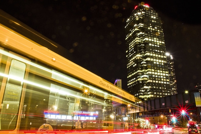
Unpredictability seems to have been the watchword of late here in Queens when the subject turns to the weather. It had been a fairly lovely evening when I started out, but a storm was going to herald the arrival of another temperature inversion and the first “spritz” of rain was beginning to appear in the air. One last tripod setup on Jackson Avenue, focused in on the Court Square station and the Sapphire Megalith of Long Island City was made serendipitous by the sudden passage of a NYCTA Bus through the frame.
Luckily, it got stuck at the light during one of the long exposure images which I was collecting all evening.
Upcoming Tours and Events
June 9th – Exploring Long Island City – with NY Adventure Club.
Long Island City is a tale of two cities; one filled with glittering water-front skyscrapers and manicured parks, and the other, a highly active ground transportation & distribution zone vital to the New York economy — which will prevail?
Tickets and more details here.
“follow” me on Twitter- @newtownpentacle


