Author Archive
Working Harbor Committee 6/15/09 tour part 1

Brooklyn and Manhattan Bridges from South Street Seaport -Photo by Mitch Waxman
After a driving rainstorm that blackened the skies over Manhattan, the very end of which I experienced while standing on Pier 16 while waiting for the hired Circleline company’s Zephyr Catamaran to return from the first of its two tours of New York Harbor being offered by the Working Harbor Committee. These esteemed maritime enthusiasts will be offering 3 more of these narrated excursions over the course of this summer of 2009. If its convenient, you too- dear reader- should consider booking passage for an interesting and revealing summer evening cruise.

Brooklyn Promenade from South Street Seaport -Photo by Mitch Waxman
The story of the destruction of New York City’s maritime neighborhoods by Robert Moses and the BQE doesn’t end when he cut Astoria in twain or screwed the Bronx up forever with the Cross Bronx Expressway.
His attempt to cleave Brooklyn Heights in half was averted by the massive wealth and political clout of the community who didn’t want to see their neighborhood turned into Long Island City. Instead, the BQE runs along the coast as a double decker highway with a cement cover on it that Moses called “the promenade“. Nobody screwed with Bob Moses, except for the governor who wrested control over federal transportation and public housing money away from him by creating the MTA, which absorbed control over Moses’s powerbase- the Triborough Bridge and Tunnel Authority in 1968.
Governor Nelson Rockefeller was the man who cut the godlike Moses down to size, having seen how the “man who built New York” operated when they worked together on building the United Nations complex.

Red Hook Container Cranes -Photo by Mitch Waxman
Confession:
As I’ve mentioned in the past, I’m a huge nerd. Comic books, Star Trek, and Lovecraft. Lots of H.P. Lovecraft. This next series of photos is from Red Hook- as in “the Horror at Red Hook“. I’m going to try and control myself but… but… MORE PEOPLE ENTER RED HOOK THAN LEAVE IT BY THE LANDWARD SIDE!!! Whew. Got that out of my system. Back to the facts.
If you click the above image, and go to its page at flickr, and then hit all sizes for the zoom-in higher resolution shots- you’ll notice these things are on wheels. They move around, and are the bridge for railroad car sized containers between land to sea transport. These are container cranes- and small ones at that- at the Brooklyn Cruise Terminal. Wait till you see the ones at the other end of the trip.
from wikipedia:
a small map of Atlantic Basin in 1849 (actual size below- sorry)


Red Hook Shoreline -Photo by Mitch Waxman
Good to see that Red Hook’s waterfront is just as available to its residents as the Queens and Brooklyn waterfront is back in the Pentacle. Fenced off, privately owned, used as vehicle parking and storage.

Red Hook approaching Erie Basin -Photo by Mitch Waxman
This was some kind of victorian warehouse, and unless I’m mistaken, this is the Beard St. Pier. Its waterfront had no fence, and it was collapsing.

Entering Erie Basin by (possibly?) Beard St. Pier -Photo by Mitch Waxman
Said collapsing waterfront- I’ve looked around online and have found pictures of this pier existing in this condition all the way back to the early 90’s. This was facing toward shore, over my shoulder were docks…

Erie Basin Tug -Photo by Mitch Waxman
This is the Tug Zachery Reinauer docked in Erie Basin. It was built in 1971 at the Matton Shipyard, and cruises at an average of 9.4 knots. It weighs 271 tons.

Manhattan Skyline from Red Hook -Photo by Mitch Waxman
This area was either the location of, or very close to, the site of the Todd Shipyards. The 12th ward is another of New York’s oldest neighborhoods- first settled by the Dutch in 1636- They called it Roode Hoek. In the 1980’s, Life magazine once named Red Hook the “crack capital of the United States”. It’s where Al Capone and Crazy Joe Gallo are from.

Erie Basin -Photo by Mitch Waxman
Red Hook was an early home to the Rapelje (Rapelye) clan- a dutch family who got into New York real estate early in the game.
from gowanuslounge.com. click here for the full post
“Joris Jansen Rapalje was one of the first white settlers on the Long Island. The Rapaljes gave birth to and baptized eleven children—the first child, Sarah, was the first European female born in what would become New York, though whether she was born in Brooklyn or upstate New York is in dispute. It is believed that the Rapaljes have over a million descendants.”
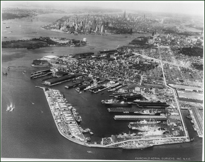
image from statesmarinelines.com/
“Erie Basin Terminal
At the foot of Columbia Street, Red Hook, Brooklyn, NY. Governor’s Island and lower Manhattan Island in the background. Circa early 1950s? Before States Marine Lines bought Isthmian.”

Tug and barge in New York Harbor -Photo by Mitch Waxman
The Tug Austin Reinauer pushes a fuel barge through New York harbor. Built in 1978 as the Morania #20- sold in 1988 as the Mobil-5- then again in 1993 as the Tamarac- as the Morania-1 in 1995- and finally as the Austin Reinauer in 1997. It cruises at an average of 10.2 knots. The barge is the RTC 100, which is a 100,000 barrel capacity fuel barge. I have to post the source for this info- check this out.
note:
Exxon is Esso. Mobil is Esso. Esso is S… and… O. S&O and all its other brand names are ultimately Standard Oil

Looking east into New York harbor from the Kill Van Kull -Photo by Mitch Waxman
All I could think of as we passed through the Kill Van Kull, was that the Newtown Creek must have looked something like this in its day. And that “they” are doing it all over again, this time in Jersey. It was a Monday night, after 7pm, and the industrial complexes on Jersey side were still humming. The Staten Island side of the waterway, however, looked small harbor town sleepy.

Staten Island Waterfront, Kill Van Kull -Photo by Mitch Waxman
Here’s an excellent history of the Staten Island waterfront story from globalsecurity.org. Staten Island’s esoteric past is well outside of my knowledge.
Also- My 2 cents say that once again, New York built a wall between its citizenry and their waterfronts.

Tug nudging ship into place at dock in the Kill Van Kull -Photo by Mitch Waxman
The tug Ellen McAllister was originally built for the U.S. Navy, as the Piqua, at the Marinette Marine Shipyards in Wisconsin in July of 1967. The Piqua’s anchorage for many years was at Holy Loch, Scotland. It spent most of its naval career providing tug services for the 1st naval district and the Atlantic Fleet. It was sold under its current name in 2001 to McAllister Towing.

Tug at dock, Kill Van Kull -Photo by Mitch Waxman
I’m sort of leaning toward this being the tug Durham- but can’t find much about a ship of that name- or a clear photo to match it with.

the Tug K-Sea Falcon -Photo by Mitch Waxman
A New York Harbor barge mover, the 3,200 BHP Falcon has a raised second pilothouse to see over its charges. It’s a youngster– built in 1990 at the Tampa Ship yards in Florida. The gigantic ship in the background is an ocean going transport ship that carries automobiles.

Floating Dry Docks, Staten Island -Photo by Mitch Waxman
That’s a tugboat in that floating drydock. It’s the K-Sea Coral Sea- a 3,280 horsepower, 193 gross ton tug that, along with a long career all along the atlantic seaboard, participated in the evacuation of the World Trade Center site on September 11, 2001. It was built in 1973 as “the Venturer” at the Houma Louisiana Main Iron Works yards. This floating drydock is most likely the Cadell Dry Dock and Repair Co.
from wikipedia:
A floating drydock is a type of pontoon for dry docking ships, possessing floodable buoyancy chambers and a “U” shaped cross-section. The walls are used to give the drydock stability when the floor is below the water level. When valves are opened the chambers are filled with water, the dry dock floats lower in the water, allowing a ship to be moved into position inside. When the water is pumped out of the chambers, the drydock rises and the deck is cleared of water, allowing work to proceed on the ship’s hull.

Newark bay skyline, from Kill Van Kull -Photo by Mitch Waxman
Finally, at the western side of the Kill Van Kull, we near the Bayonne Bridge and see the Newark Bay skyline in the west with the setting sun behind it. Luckily, the date chosen for this excursion was perilously close to the summer equinox (Beltane), and despite the late hour- the burning sun still stared down upon New Jersey- and the culmination of the journey- Newark Bay and Port Elizabeth.

Down under the Bayonne Bridge- aka DUBBO -Photo by Mitch Waxman
But that’s on the other side of the Bayonne Bridge… and another post
as always, if something you read here is contradicted by something you know, contact me. Additions and corrections are always welcomed.
Adventures upon the East River 3
The last bit of the Queensboro Bridge Centennial Celebration was a narrated river cruise that circled from the 23rd street docks in Manhattan up the East River, past Roosevelt Island, under the bridge, and then turning at Hells Gate and returning to 23rd street.
Here’s what I saw:

Chrysler Building Manhattan Skyline, from the East River -Photo By Mitch Waxman
It was one of the few sunny days in June 2009, the 6th, that the Marco Polo Boat tour left for its short journey up the river. The narrators onboard the trip were Bernard Ente, and Dave Frieder. We slid up the west channel at first for the initial part of the trip and were greeted by panoramic views of iconic New York architecture like the 77 story Chrysler Building. The second tallest (surviving) building in NYC- construction began in september of 1928 at the behest of the Chrysler automobile company, and it was designed by William Van Alen.

United Nations Building, from the East River -Photo By Mitch Waxman
Oh… LeCorbusier and Niemeyer- this is one you got right- other than the leaky roofs and windows. I am not a fan of Le Corbusier, let me just say.
His idiotic notion of stacking communities into vertical spires surrounded by parkland (modern Long Island City’s Queens West near Gantry Park comes to mind) is the greatest formula for the destruction of civic awareness and “neighborhood” since… ever. The urbanist theory that the monolithic public housing projects manifested by the 20th century’s obsession with Urban Renewal would somehow benefit the urban poor comes from LeCorbusier. The rich live in their own version of this concept- the condo building.
LeCorbusier is responsible- ideologically and in some case literally- for the ring of poverty surrounding Paris, the council housing of London, the housing complexes of Chicago, and of course- New York’s rather disastrous experience with “the projects”. He was the Ayn Rand of architecture.
here’s what he wanted to do in Paris, from wikipedia:
Theoretical urban schemes continued to occupy Le Corbusier. He exhibited his Plan Voisin, sponsored by another famous automobile manufacturer, in 1925. In it, he proposed to bulldoze most of central Paris, north of the Seine, and replace it with his sixty-story cruciform towers from the Contemporary City, placed in an orthogonal street grid and park-like green space. His scheme was met with only criticism and scorn from French politicians and industrialists, although they were favourable to the ideas of Taylorism and Fordism underlying Le Corbusier designs. Nonetheless, it did provoke discussion concerning how to deal with the cramped, dirty conditions that enveloped much of the city.
here’s what his politics were, also from wikipedia:
Le Corbusier moved increasingly to the far right of French politics in the 1930s. He associated with Georges Valois and Hubert Lagardelle and briefly edited the syndicalist journal Prélude. In 1934, he lectured on architecture in Rome by invitation of Benito Mussolini. He sought out a position in urban planning in the Vichy regime and received an appointment on a committee studying urbanism. He drew up plans for the redesign of Algiers in which he criticised the perceived differences in living standards between Europeans and Africans in the city, describing a situation in which “the ‘civilised’ live like rats in holes” yet “the ‘barbarians’ live in solitude, in well-being.”[10] These and plans for the redesign of other cities were ultimately ignored. After this defeat, Le Corbusier largely eschewed politics.
Until he designed the United Nations Secretariat, a 39 story building and complex located in Turtle bay, Manhattan. This part of Manhattan is not part of the sovereign territory of the United States, incidentally, its legally international territory and not subject to the laws of New York City or the USA unless the U.N. says so. Here’s the proviso:
United Nations, Pub. L. No. 80-357, 61 Stat. 756 (1947): “Except as otherwise provided in this agreement or in the General Convention, the federal, state and local courts of the United States shall have jurisdiction over acts done and transactions taking place in the headquarters district as provided in applicable federal, state and local laws.”
Interesting note:
The land that the complex sits was purchased from William Zeckendorf (a mid 20th century real estate baron) in a deal brokered by the Chase Manhattan Bank. Chase, of course, was the instrument of future New York Governor and United States Vice President Nelson Rockefeller. Grandson of John D. Rockefeller, and inheritor (with his brothers) of the Standard Oil fortune. The Rockefellers had already offered some of their own land- the house that Standard Oil built- and Rockefeller family castle,in Westchester, for use as the potential seat of a world government- but it was “too far away” for the diplomats. So, he had his father- John D. Rockefeller Jr. buy Turtle Bay and donate the land to the city for the UN.
The area called Turtle Bay was where the Draft Riots of 1863 started, and it was a neighborhood of tenements, butchers, slaughterhouses, and dangerous organized crime controlled docks which handled the traffic coming to and from Long Island City via rail and barge. The United Nations building was completed in 1950.
1950 is also when the decline of the economic infrastructure of North Brooklyn and Western Queens, especially the area around the Newtown Creek in Queens and Red Hook in Brooklyn, began in earnest. Connected? Maybe.

U Thant (or Belmont Island) with Commorrant Nursery. LIC in background, from the East River -Photo By Mitch Waxman
This was cool.
In the 1890’s, the redoubtable William Steinway was attempting to establish trolley service to Manhattan via an East River tunnel. A granite outcrop near Turtle Bay, the Man’O’War, was built up with landfill from a shaft tunneled from the subaqueous worksite below. The result was Belmont Island – the 100×200 foot patch of rock right in front of the modern UN building. In 1977, Sri Chinmoy renamed the island after the then Secretary-General of the United Nations- U Thant. Hence- U Thant island. The weird curvy structure, in addition to being a bird sanctuary, is a “Oneness” arch. The Steinway Tunnel is currently owned by the Metropolitan Transit Authority (MTA) and carries the 7 train into Manhattan from Queens.
And the MTA was established in 1965 by Governor Nelson Rockefeller. Here’s the system.

Queensboro bridge, as it enters Manhattan, from the East River -Photo By Mitch Waxman
I always have to ask. That apartment that’s on eye level with the subway track, and the one 2 flights up that’s level with the roadways… who lives there? Is it ever dark, or quiet?

Queensboro bridge, Roosevelt Island tower, from the East River -Photo By Mitch Waxman
Queensboro used to have an enormous vehicular elevator building which carried cargo down to the “hospitals” here on Roosevelt (welfare) Island.

Queensboro bridge and Roosevelt Island Bridge, from the East River -Photo By Mitch Waxman
A concurrence of arches greeted us after the turn, the boat is now traveling in the East Channel of the river.

Roosevelt Island Bridge and the Big Allis Power Plant, Ravenswood shoreline, from the East River -Photo By Mitch Waxman
The only way, by land, to get to Roosevelt Island is this 1955 vintage lift bridge. It lifts to 100 feet off the river, severely limiting the size of ships which can cross from Long Island Sound and New York Harbor and creating a traffic bottleneck on the west channel. Big Allis, or Ravenswood 3, looms over the crossing.

Big Allis Power Plant, Ravenswood shoreline, from the East River -Photo By Mitch Waxman
I did a post on Big Allis a little while back, but I’ve never quite seen it from the river. These are fuel barges, apparently, in the process of delivering the fuel that will generate 16% of New York City’s electricity each and every day.

Queensboro bridge, Ravenswood tower shoreline, from the East River -Photo By Mitch Waxman
Deplorable. Look at this riverfront, locked away from the public by Citibank and Consoldiated Edison and the City of New York. Used as a dump and vehicle storage area by the City, ConEd has a high security set of picnic tables set up here, and Citibank is allowing the landmarked Terracotta House to crumble. Queensbridge park ends on the left side of this image and its “boardwalk” is a half submerged, fenced off mastaba of cement collapsing into the East River. Shame.
That’s the swank new Ravel Hotel, on the right, which is where I got to watch the fireworks from.

Queensboro bridge, Ravenswood tower shoreline, from the East River -Photo By Mitch Waxman
For the rest of the Queensboro Bridge event stuff, click here
Newtown Grafiti
Ms. Heather over at NYshitty recently ran a piece on some interesting runic grafiti found in Greenpoint, Brooklyn. Examination by her extensive network revealed a sinister meaning to the appearance of these runes. Connections to the late 19th century German mystics and conjurers who inspired Hitler’s Wagnerian mythos emerged.
As I’ve ambled across the Newtown Pentacle in the last few years, I too have noticed odd grafiti that hints of esoteric knowledge. My interests and studies have crossed the left hand path more than once, and I have the eye of one acquainted with an iconography of the occult. The Pentacle is steeped in magick all the way back to the Dutch.
This makes sense, as the pastoral shamanism of the Koreans and the ghost worshipping of the Catholics stands cheek by jowl with Nestorian Christianity and the Yesidi clan of Kurdish devil worshippers (here’s one of their holy books- I shit you not). Mohammedan or Hasid, Presbyterian or Hindoo, all the mainstream faiths in the area have thrown great spires at the sky and filled the socratic skyline with their particular “gnosis”. The one thing all these people have in common, other than problems with subway service, is that every one of these churches has its apostates. The Catholics have Opus Dei, and the Muslims have the Sufists.
Groups of true believers who think that the “big church” has lost its way, these philosophies offer hidden truths and revelation. Cults, or as we might say it in modern newspeak- “self organizing grass roots gatherings of religious enthusiasts”. Often, these cults form within gangs. The South American and Mexican gangs, in particular, are known to employ magicians called “Padrinos” to amplify their advantages in hostile encounters. If you believe in magick, it works. They do.
In February of 2009, during a religious ritual in Flushing, a 6 year old was burned with “accelerants”. Invocations of a Loa often involve spitting flaming rum at the intended participant of the ceremony. Santeria (and its black magick equivalent- Palo) also employs similar magickal techniques and symbology.
Also… how does Aleister Crowley always end up getting into the mix? The goetia, which that nasty man said was “the Lesser Key of Solomon” contains ritual sigil designs that are very similar to designs found appearing all over Astoria since mid 2007. A better thing to read, would be this. Seriously, this is the craziest thing you’ll see today. Ok, maybe this is.
If you’re interested in this sort of thing, I would suggest reading up on the Rosicrucians, The Order of the Golden Dawn, Madame Blavatsky and the Theosophists, and the 19th century Spirititualist movement. Compare with the “model tenement” movement, John Harvey Kelogg, and eugenics. The occult inheritances of these debauched philosophies have filtered out into popular culture as Veganism, New Age Movement, Alcoholics Anonymous and the Recovery Movement, and a series of badly spellchecked grimoires which all refer to themselves as “the Necronomicon”.
At the end of the 19th century, occult topics played well in the absinthe fueled cocktail party culture of the middle class- the “sustainable living” and “green technologies” conversations of their day.
First, there is a difference between grafiti and occult markings. These are grafiti.

Ravenswood- This is a “tag”, a kind of grafiti which is painted or etched with differing levels of artistic merit. Often, taggers will “bomb” a neighborhood, leaving behind dozens if not hundreds of iterations of their particular icon. Often the tag will refer to gang or ethnic affiliations -photo by Mitch Waxman

Sunnyside Yards Honeywell Bridge Tag. The top right looks sigili-ish, but the 187 (police code for an undercover cop in trouble) indicates this is New York Street culture oriented -photo by Mitch Waxman

Street work painted by DOT. An amazing coincidental drawing of a theoretical tesseract or hypercube -photo by Mitch Waxman
The next two are Latin Kings tags. No affiliation or hate.

Astoria Latin Kings tag -photo by Mitch Waxman
I hesitate to post anything about… umm… self organizing fraternal societies of urban youth- but these are Latin King tags. The number of points in the crown has some significance which I am ignorant of, the presence of circles amongst the points which indicates political standing or factional allegiances of the tagger to the citywide organization is also something I am completely ignorant about. Go ask a King.

Woodside Latin Kings tag -photo by Mitch Waxman

Dutch Kills abandoned factory: Part of a series of enigmatic scrawls found in a muddy place where no footprints could be seen -photo by Mitch Waxman
Now, either by design or accident of design- the occult::

This is in one of the isolated spots in Long Island City. Similar to Ms. Heather’s runes, these are under the LIE and over the LIRR in Long Island City, behind the midtown tunnel -photo by Mitch Waxman

Mt. Zion altar. Found this on 59th street while walking the Mt. Zion cemetery fenceline. It was a little wooden mortar and pestle with coarse gray ash inside of it. There was candle wax as well -photo by Mitch Waxman

This is a fairly modern, post-industrial era sigil representing the demon Asmodeus. Lamp pole in Astoria -photo by Mitch Waxman

Astoria, chaos dragon/snake mother sigil. Compare with the ancient Naga of the Mahabharata -photo by Mitch Waxman
and another one, miles away in Ravenswood-

Ravenswood Sigil -photo by Mitch Waxman
Obviously the work of a small group or possibly even one person, this next grouping started turning up all over astoria since middle 2007. The one with my shadow in it is in Maspeth, by an abattoir.

Occultish grafiti found along the fenceline of a gigantic Korean Church -photo by Mitch Waxman

Occultish grafiti found in Astoria -photo by Mitch Waxman

Occultish grafiti found in Astoria -photo by Mitch Waxman

Occultish grafiti found in Maspeth -photo by Mitch Waxman

Occultish grafiti found in Astoria -photo by Mitch Waxman

Occultish grafiti found in Astoria -photo by Mitch Waxman

Graphomania like this is all over the place, and gets denser as you travel toward Corona and Roosevelt. Most likely a mexican or ecuadorian fraternal group. Read the text from multiple angles and directions. Correct orientation will be apparent to members. Standard fenceline style of code -photo by Mitch Waxman

Occultish grafiti found in Greenpoint -photo by Mitch Waxman
Of course, Queens being Queens… some things require little or no explanation

Dutch Kills -photo by Mitch Waxman
Adventures upon the East River 2

The Tug Pegasus, doing Tourist duty- Photo By Mitch Waxman
From the Tug Pegasus Preservation Project website (be sure to check out the blueprints):
“The tugboat Pegasus was built in 1907 as S. O. Co. No. 16, for the Standard Oil Company of New Jersey, by the Skinner Shipbuilding Yard of Baltimore, Maryland.
The Skinner yard had a long history. There had been shipbuilding on that site at the foot of Federal Hill since 1783. Zachariah Skinner established his yard there in 1832 to build small schooners for the Bay and coastal trades. By the 1870s, the yard had produced some of the finest steamboats operating on Chesapeake Bay.
The yard survived into the 1980s, at the end under the ownership of the Bethlehem Steel Company. Bethlehem preserved most of the Skinner plans from the early twentieth century, including many for No. 16 and her sisters. These plans are now in the collection of the Baltimore Museum of Industry.”
Interesting how Standard Oil, so long after its day, is still on the river. John D. Rockefeller is still one of New York’s influential citizens.

NYFD fireboat, which (I’m fairly sure) is the Firefighter- Photo By Mitch Waxman
The Firefighter is a National Historic Landmark. Built in 1938, this was the NYFD’s most powerful diesel-electric fireboat when she joined the fleet. Serving as Marine Company 9, Firefighter participated in putting out over 50 major maritime fires in the last 71 years- including the SS Normandie Disaster, the collision of the Esso Brussels and the SS Sea Witch. Firefighter also helped to quench the fires of September 11, 2001. Firefighter is scheduled for a well deserved retirement this year.

Staten Island Ferry- Photo By Mitch Waxman
The Staten Island Ferry pulling into its Manhattan docks. This particular ferry is the “Spirit of America”- whose spirit, I guess, can be expressed-metaphorically– as a giant orange boat.
This particular giant orange boat is a “Molinari” class ship that can carry 4,500 passengers and 40 vehicles. The docks are called South Ferry, and serve as a transportation hub with connections to both IND and BMT subway tracks. The City’s fleet of ferries makes the 5 mile trip to Staten Island in 22 minutes. Vehicles used to use the Ferry to transit to the St George terminal on the far side, but fear of terrorism has reduced the ferry to passenger only service since September 11th. For the full story on the Staten Island Ferry, check out the wikipedia article here, and the official NYC website here.
Interesting note…
the original Ferry service, the one that was bought in 1838 by Cornelius Vanderbilt, was bought by the B&O railroad in 1884. B&O- as in Canton Iron- as in Peter Cooper– as in Cooper’s Glue from the Newtown Creek. Also, as the story progresses, B&O, through acquisitions and mergers morphs into the Pennsylvania Railroad which ends up owning the Long Island Rail Road running freight to Manhattan along the Newtown Creek.

Brooklyn Bridge, from the East River, Manhattan Tower and skyline.- Photo By Mitch Waxman
Built in 1883, the iconic span was slapped with its current moniker because of a letter to the editor at the Brooklyn Daily Eagle, and officially pronounced “da Brooklyn Bridge” in 1915. For all the history on this, watch the Ken Burns documentary or hit the the wikipedia page.

Brooklyn Bridge, from the East River, Manhattan Tower and skyline.- Photo By Mitch Waxman
What I can tell you is this place holds a weird reputation, and has claimed a lot of lives over the years. Its a favorite spot for suicides, and some woman on the Manhattan side claims to have been abducted by a ufo- from her apartment. Said apartment is behind the largish white building to the right of the bridge. I knew a couple of Goth girls that liked to come down under the FDR drive by the tower, back during the 80’s, to play witch. They said it was “a place of power”, got high, and lit candles inside a sidewalk chalk circle.

Brooklyn Bridge, from the East River- Photo By Mitch Waxman
NYPD doesn’t keep an official record of suicides, at least not publically. Once, it was quite in vogue to jump from the bridge. A fellow named Donaldson tried to jump 3 times before construction was even finished, a professional daredevil named Odlum learned a few fatal facts about physics in 1885, and then… there was Steve Brodie.

Brooklyn Bridge, from the East River- Photo By Mitch Waxman
As I’ve mentioned before, I’m from Brooklyn. The part of Brooklyn that says “Erl Cumpnie”, and “Doity Boid”- a place where the “F word” is simultaneously a verb, noun, synonym, term of affection, and adjective. When using the “F word in polite” company, one uses “effin”. The pizza is very, very good there. So are the bagels.
Steve Brodie was some kind of weird iconic figure to my dad and uncles, who grew up during the Great Depression. Brodie, apparently was bookie. He jumped off the Brooklyn Bridge to win a bet. When you’re from Brooklyn, and someone dares you to do something, and you have money on the line, you either do it or you’re an effin… well that’s another use of local vernacular. Brodie, of course, turns up in a Bugs Bunny cartoon as well.
image from wikipedia


Manhattan Bridge, from the East River- Photo By Mitch Waxman
The steel colossus next door to the Brooklyn Bridge- this thing carries 7 lanes of cars and truck traffic and also has 4 subway tracks, and a couple of pedestrian/bicycle ramps. It connects Manhattan’s lower east side to the Fulton Landing in Brooklyn, now called DUMBO.
from nycroads.com
PLANNING “SUSPENSION BRIDGE NUMBER 3”: The Manhattan Bridge was first planned as a traditional wire-cable suspension bridge to be used exclusively by trains. In 1892, elevated railway magnate Frederick Uhlmann proposed this span just north of the present site of the Manhattan Bridge. The bridge was planned in conjunction with another one of his proposals, the Williamsburg Bridge. While Uhlmann’s railroad bridge was never constructed, the Williamsburg Bridge was approved in 1895 to handle mixed traffic.

This tug, the Dorothy J, is pushing a barge of shredded autos, most likely coming from the Newtown Creek, down the East River. Manhattan Bridge in background- Photo By Mitch Waxman
Moving under the Manhattan Bridge, our trusty vessel passed a tugboat, the Dorothy J. was threading a load up the East River. My friend, by whose largesse I was enjoying these splendid times on the waters surrounding New York, advised that it most likely coming from the auto salvage operations on the Newtown Creek. Inset below are images of just such a business on Newtown Creek, viewed from the Newtown Creek Wastewater Treatment Facility Nature Walk. Yes, you read that correctly. It’s actually sort of lovely.

Auto recycling at the Newtown Creek, from “newtown creek nature walk with George Trakas”- Photo By Mitch Waxman

This tug, the Paul Andrew, is pushing a barge of shreded autos down the East River. Most likely coming from the Newtown Creek. Williamsburg Bridge in background- Photo By Mitch Waxman
Soon, another Tugboat- the Paul Andrew passed by bearing a similar load of in the process of being recycled autos. Below can be found one of my controversial challenges to conventional orthodoxy and challenge to use “institutional memory” when thinking about modern times:
Something to consider, says wise Old Mitch, is that contrary to what most people think- recycling is probably the least “green” industry there is. Think the whole chain through- toxic materials, gathered from every festering hole that New Yorkers can stuff garbage into, loaded onto diesel trucks, and carried to concentration points in places like Greenpoint and Long island City and Maspeth. All around the Creek, industry reduces these materials to constituents, and in turn, the valuable elements are loaded onto barges and and eventually shipped to infinitely distant capitals in (currently) Asia for resale and manufacturing. So, ummm, what do you suppose happens to the stuff that nobody wants? The oil that drips, the printing inks, and all the little bits of paint? Where do you suppose that goes, and whose ground water is poisoned? Were the Night Soil docks green? And can I open a recycling center next door to your house?
I’m just saying…

Auto recycling at the Newtown Creek, from “newtown creek nature walk with George Trakas”- Photo By Mitch Waxman

Williamsburg Bridge, from the East River- Photo By Mitch Waxman
Not quite the monolith that Manhattan is, nor as stylish as the Brooklyn, the Williamsburg bridge connects Delancey Street with the tony Brooklyn neighborhood for whom the span is named. To any longtime Brooklynite, of course, calling Williamsburg tony always brings a smile. Up until yesterday, this was one of the skeeviest parts of Brooklyn. Bedford and Grand was four corners of brick lots with naked hookers roaming the deserted streets. A small community of Hasids lived here, with most of the population in the projects. It was so bad in the late 80’s that my friends wouldn’t even drive down here, and a threat was “I’ll leave you in Williamsburg…”.

Williamsburg Bridge, from the East River- Photo By Mitch Waxman
The bridge’s Manhattan landing is in another of New York’s 1980’s garden spots- the Lower East Side. Used to be dangerous and fun, now its safe and boring.

Empire state and public housing, former (today would be superfund) siting of part of the Gaslight District- Photo By Mitch Waxman
As we moved back up the river to our eventual docking at 23rd street, we passed by two more items of interest. Once, when it was its own lonely self with only part of the Bronx for company, Manhattan had to actually do all the nasty industrial stuff for itself- or pay through the nose to anyone in Brooklyn or Long Island City with their hands stuck out to generate power or handle sewage or manufacture things- which is the way Manhattan does it now. These buildings, which are public housing, sit either on or just south of the former location of Manhattan’s gas light district.
Editorializing again:
The “wild hunt” of the industrial revolution came in the night . Amongst their number were cholera, and tuberculosis, and the timeclock- and the period after the civil war was their first real attempt at subjugating nature. and first real chance at the complete destruction of the nature of mankind. The tenements fed the bosses labor, hapless mendicants who were consumed by the “dark satanic mills”. If a worker was sick, or killed, 10 more were waiting for “their place”. Industry ran wild in Manhattan during this time. Hell’s Kitchen on the west side got it’s name from just such a gas work as the ones that were sited here. Matter of fact, the people who swept away all the bad stuff down here in the early twentieth century, they were named Rockefeller. The electric industry grew out of the gas industry. They grew on top of it, and sold all the properties they didn’t need anymore- the reeking tanks and leaky pipes could be someone else’s problem.

United States Coast Guard’s ship, Katherine Walker- Photo By Mitch Waxman
Below 14th street and above Delancey, the east side was bristling with docks and sailing vessels being fed textiles, and iron, and manufactured goods of every kind from a vast industrial zone. Today, there was just us and a Coast Guard ship.
The power plant behind the ship is the East River Generating Station, and the ship is the Coast Guard’s Katherine Walker.
from Sorabji, a member of our Flickr Gorup
This is a comment reply to my “The Cemetery Belt” posting a while back, and I didn’t want it to get buried in the comments. I started up a Newtown Pentacle Flickr Group (please join us as a member and post your stuff) and met Sorabji there. Here’s his comments and links out to some great photos from Old Cavalry.
I have been roaming Old Calvary for years, and have done a fair amount of research into the mighty Johnston Mausoleum, as well as the Civil War Memorial — the latter is one of my favorite cemetery finds in New York, while the mausoleum is an ongoing fascination of mine.
The War Memorial is in bad shape after 150 years of exposure to the elements but in 2007 Parks began a restoration of the work, starting with a coat of paint placed on one of the 4 life-size statues. I may be in a small minority when I say this but I was excited to see this charming memorial get some sorely needed attention, and I anticipated that the job would mirror the restoration of a similar monument (by the same family of sculptors) at Green-Wood Cemetery several years earlier.
Alas, the work begun on the Calvary War Memorial in 2007 seems to have halted, probably for want of financing to continue the project, and now the marker is decidedly lopsided with three of the statues looking like pulverized metal with just one of them sporting a coat of dark green paint. It seems further unfortunate that the work done on that one statue appears to be wearing away already. It is an unfortunate situation but in these strained financial times I guess it is not surprising that a relatively obscure project like this might fall off the radar of the city’s attention.
I have several pictures of the War Memorial (maybe a few too many pictures) at this address:
http://www.sorabji.com/pictures/cemeteries/Calvary_Veterans_Memorial/
I plan to summarize the research I’ve shared in those pages into a single page, and I hope to open it up for discussion on a new message board I’m setting up at sorabji.com.
The War Memorial is only one of the many items I have followed with interest at Calvary over the years. I love that place.
Later today, look for the second installment of “Adventures upon the East River” and the 3rd LIC post is STILL in the works. I’m having issues with conflicted sources, and with significant amounts of the information sourcing back to copyrighted materials. Working on it, and its coming soon.


