Archive for the ‘Pennsylvania’ Category
Duck Hollow Trail, too
Tuesday

– photo by Mitch Waxman
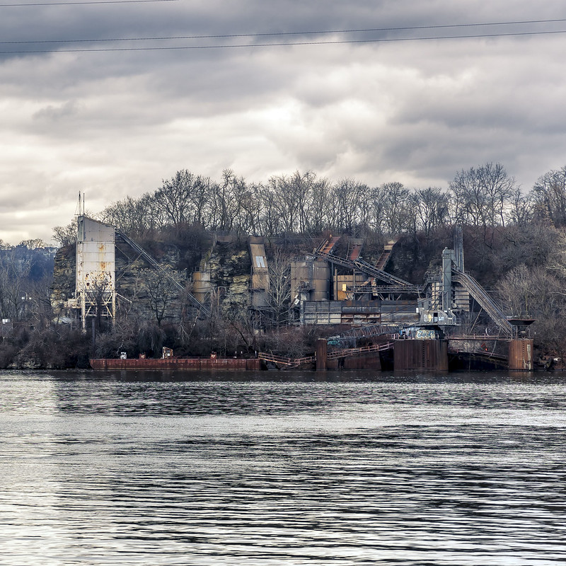
As described yesterday, a humble narrator was enjoying an inaugural walk on the Duck Hollow Trail, here on the northern bank of the Monongahela River in Pittsburgh. During this ‘short walk,’ industrial leave behinds like the intricacy pictured above were encountered. The Homestead Steel Mill used to be located on the southern shoreline of the river, so it’s pretty easy to speculate on the purpose of the relict machinery here.
I had to do a bit of climbing for this shot, as the thing was obscured by feral vegetation. To me, this looks like the sort of conveyor belt system you’d use to transport bulk materials like coal or coke from a train to a river going barge (there were two sets of tracks in this area, one was the right of way that the trail occupies, and there’s parallel system which is still active is about a hundred feet away).

– photo by Mitch Waxman
This is what it looked like from the trail, hence the climbing. I had maneuvered myself onto one of the steel beams at the lower right hand side of the shot above for the first view. It wasn’t exactly a graceful climbing exhibition. I’m no Squirrel, but I do aspire to Monkey.
As stated hundreds of times over the last 13 months, I’ve been scouting while out shooting and scuttling about. Still looking for the ‘POV’s.’

– photo by Mitch Waxman
Back in April of last year, I attended a boat tour up the Monongahela River, and happened to get a photo of this contraption from the water side – which is the shot embedded above. Like I said – scouting.
Based on the graffiti, this seems like a ‘thing’ for the local youths to visit, but don’t know much more about it than the speculation offered above.
Residential Pittsburgh in this section occupies a much higher in altitude position than this waterfront does, and a steep landform rises up about a hundred to a hundred fifty feet away from the water. The neighborhood of Squirrel Hill is found up there, on the landform.
I analogize Squirrel Hill as being culturally a lot like the part of NYC’s Brooklyn which starts in Midwood along Kings Highway in the 30’s streets, and then continues over to Ocean Parkway, in the alphabet avenues. Largely populated by Middle Class Jewish folk in terms of population, Squirrel Hill is, which completes and colors my analogy to ‘the old neighborhood.’

– photo by Mitch Waxman
The Duck Hollow Trail’s offerings officially terminate at a smallish rail yard, which encountered signage described as being called Glenwood Junction. A worn footpath in the brush indicates that people don’t automatically stop at the train yard and continue on along its periphery. Maybe that’s how you connect to the rest of the Three Rivers Heritage Trail.
Me? This was my predesignated ‘turn around’ point for the day, exactly 2.5 miles from where I had parked the Mobile Oppression Platform.
I will never, ever, stop being grateful for the maniacs who run the Queens branch of NYC’s Transportation Alternatives lobbying outfit for describing ‘SUV’s’ as Mobile Oppression Platforms. Such enrichment is inspirational, so when Toyota insisted I give the car a name, this became my only choice. I also enjoyed their ‘two ton death machine’ terminology, and their assertion that every driver exists in a state of ‘pre murder’ once they put the key in the ignition. Good stuff.
As a note, when somebody insists that I offer my preferred pronouns, my answer is “It” and “That.”

– photo by Mitch Waxman
I found myself under the Glenwood Bridge in this spot. It’s a ‘Warren Through Truss’ type bridge, made of steel, and it has carried four lanes of PA 885’s vehicular traffic over the Monongahela River since it was opened in 1966. It connects the two ‘north side of the river communities’ of Hazelwood and Glenwood with a south side section called Hays.
I found myself wandering a bit too close to the rail yard here, which seems to be something that Pittsburgh’s Yinzers do often, but I come from a place which offers the citizenry tickets for spitting gum on the sidewalk and hosts a police force that’s larger than some country’s armies, so I obeyed my original plan and reversed course.

– photo by Mitch Waxman
One noticed this swing set up under the bridge, a companion to the tire swing in the last shot. Couldn’t help but pop out a shot and start heading back to the MOP. Things to do back at home, and projects which needed attention, all that.
I regret not climbing onto the swing for some ad hoc fun, I’d mention. Need to play more, me.
Back tomorrow.
“follow” me on Twitter- @newtownpentacle
Buy a book!
“In the Shadows at Newtown Creek,” an 88 page softcover 8.5×11 magazine format photo book by Mitch Waxman, is now on sale at blurb.com for $30.
Duck Hollow Trail
Monday

– photo by Mitch Waxman
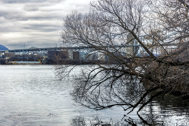
Found on the north shore of the Monongahela River, opposite the community of Homestead, one will find the Duck Hollow Trail is laying in wait. I’ve spotted this trail – in the past and onboard a boat – and as I’m always looking for someplace new to go (luckily, everything in Pittsburgh is pretty much new to me) for one of my walks, decided to drive over on a recent afternoon and check this public facility out.
There are markers embedded in its path, indicating that this is part of the Three Rivers Heritage trail network of interconnected paths, but one is at a loss as far as finding the connection at its western terminus to the rest of the trail. On this particular day, which was a ‘short walk’ occasion of around five miles, one scuttled down about half of the trail.

– photo by Mitch Waxman
There’s parking, so I positioned the Mobile Oppression Platform – pictured above – with a nice view of the Homestead Waterfront across the waters of the Monongahela. Why shouldn’t the MOP enjoy a nice view? On a related note… I really have to get the car washed sometime soon.
After donning my camera, bag and affixing a 28-105 zoom lens to the camera, one leaned into it and sallied forth.

– photo by Mitch Waxman
That’s the Homestead Grays Bridge pictured above, named for the famous ‘Negro League’ Baseball outfit, and that’s one whopper of a bridge – which opened in 1937. It’s 3,750 feet long with its approaches, connects the Squirrel Hill section on the north side of the river with the Borough of Homestead on the southern bank, all the while providing some 108 feet of clearance over the waters of the Monongahela. It’s also the first built example of an engineering feature called the Weichart Truss, something you can read up on along with all its nitty gritty, at this page at aisc.org.
The trail itself had more of those ‘high slopes and difficult to get to the water’ setups which I’ve described in previous posts along the Ohio River, but under the Homestead Grays Bridge I was able to scuttle right down to the shoreline. Again, I have to figure that this built up banks situation is about flood control during spring thaws.

– photo by Mitch Waxman
Most of the trails in the Pittsburgh area that I’ve been visiting are ‘rail to trail’ implementations, where the footprint of a defunct right of way for a rail company that’s out of business or no longer needed have been converted over to civilian usage. These rail lines used to service the steel mills which infested these shores, and in the case of Homestead, served the largest steel mill on the planet. These rights of way have seen their tracks pulled up and have been surfaced with either asphalt or crushed limestone, but occasionally patches of soil are encountered along them. The rail grading standard of one foot in elevation per every hundred feet horizontally makes them a fairly easy walk or bike ride, and they’re very well used by surrounding communities.
For one such as myself, this sort of grading allows me to vary my walking speed consciously and get to optimum ‘heart beats per minute’ levels which provide a curative to the various health issues I enjoy. Advice from the team of doctors has always revolved around this concept, which boils down to ‘slow and steady wins the race.’

– photo by Mitch Waxman
Somehow, I always manage to navigate myself to a spot where I’m happily standing in front of an open sewer. This one looks like a storm sewer, to me. Presumptively it’s draining off of the bridge’s vehicle lanes above, but there are also communities and residential developments lining the shoreline here so it might be performing ‘neighborhood’ based combined sewer duty as well.
I kept an eye out for homeless encampments and signs of morbid habitation along the shoreline when I’m shlepping along, but didn’t observe any signs of homeless villages nor vagabonds. I literally have zero fear regarding these encampments, instead I want to be respectful to folks who are already living through quite a rough time.

– photo by Mitch Waxman
One continued along his way, with a predetermined ‘turnaround point’ in mind that’s nearby a small railyard. If you’re curious about locale, this shot was gathered roughly here. The wooded sides of the trails were pretty typical for the region. Lots of birds, signs and tracks of nocturnal mammalian presence (raccoons etc.), and while scuttling along I encountered a few humans who were riding bikes, walking dogs, and or jogging or just walking along.
It’s nice, and I stuck my headphones into the ear holes to listen to one of the audiobooks I keep on my phone. This time around it was a dramatization of H.P. Lovecraft’s ‘Shadow over Innsmouth.’
More tomorrow.
“follow” me on Twitter- @newtownpentacle
Buy a book!
“In the Shadows at Newtown Creek,” an 88 page softcover 8.5×11 magazine format photo book by Mitch Waxman, is now on sale at blurb.com for $30.
Ten mile scuttle, part six
Friday

– photo by Mitch Waxman
I punked out on the last section of my walk, and headed over to the T Light Rail Station on Pittsburgh’s First Avenue to catch a ride back home. Of all the T stations I’ve visited, the one that looks the most ‘right’ to me is First Avenue.
On your way out of Pittsburgh, you either pay when exiting the T or at the Station you’re getting out at. It’s all very confusing.

– photo by Mitch Waxman
Back in Dormont, after debarking the T and getting a Gatorade at the gas station across the street, I stopped off for a quick shot of a Pittsburgh bound train set picking up passengers.
I began my scuttle down the hills towards HQ, with a genuinely weary gait. I had walked somewhere just over ten miles in about three hours.

– photo by Mitch Waxman
As I faced down the ice on the steep hill of the block that HQ is found at the bottom of, I cracked out one last shot of a lovely little house that has just changed hands at the top of the hill. I know the place is vacant, so I was positive that nobody’s privacy was going to be pierced by clicking the shutter.
According to Zillow, this 1,104 square foot, three bedroom and two bathroom house just got sold for $319,000. There’s a driveway, and a pretty big yard, too. Sweet.
Back next week.
“follow” me on Twitter- @newtownpentacle
Buy a book!
“In the Shadows at Newtown Creek,” an 88 page softcover 8.5×11 magazine format photo book by Mitch Waxman, is now on sale at blurb.com for $30.
Ohio Digestif
Friday
– photo by Mitch Waxman
This is a short one, filed under ‘Odds and Ends.’ After taking a short walk up the Ohio River and turning around at the Western Penitentiary campus, here in Pittsburgh, I was quick stepping it back to the car.
The quick steps thing was about getting my heart rate up to a certain level and maintaining that speed for an interval. Cardiology, amirite?
– photo by Mitch Waxman
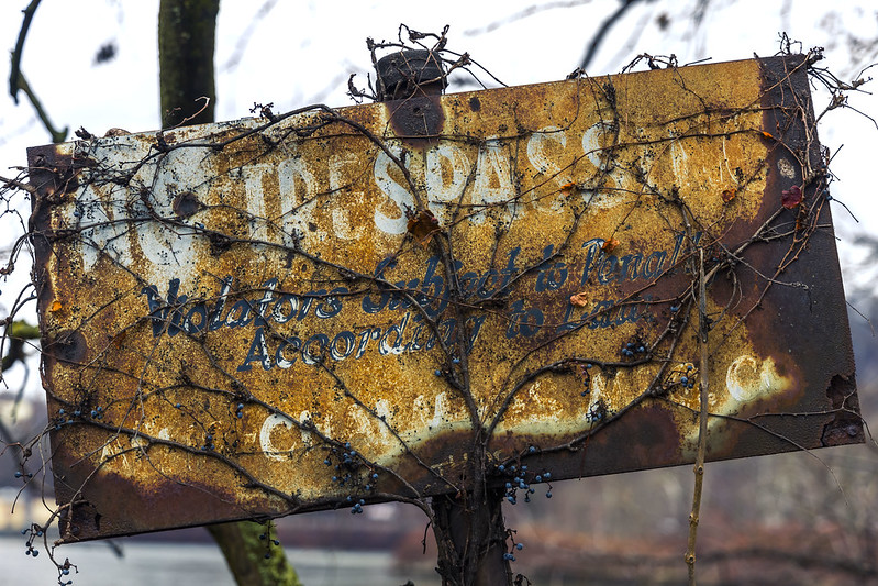
Along the way, I grabbed a few opportune shots, including one of what seems like an abandoned concrete factory on Brunot’s Island.
Man, if I ever find a way onto that landform, I’m heading straight for this spot.
– photo by Mitch Waxman
I love a rusty sign, especially one which hosts a message from an earlier era’s governmental bureaucracy, or some long shuttered business, admonishing or threatening arrest for trespass. I always found this sort of thing to be quite useful from a historical POV, along Newtown Creek and the East River.
Back next week.
“follow” me on Twitter- @newtownpentacle
Buy a book!
“In the Shadows at Newtown Creek,” an 88 page softcover 8.5×11 magazine format photo book by Mitch Waxman, is now on sale at blurb.com for $30.
The Pen in Western Pennsylvania
Thursday
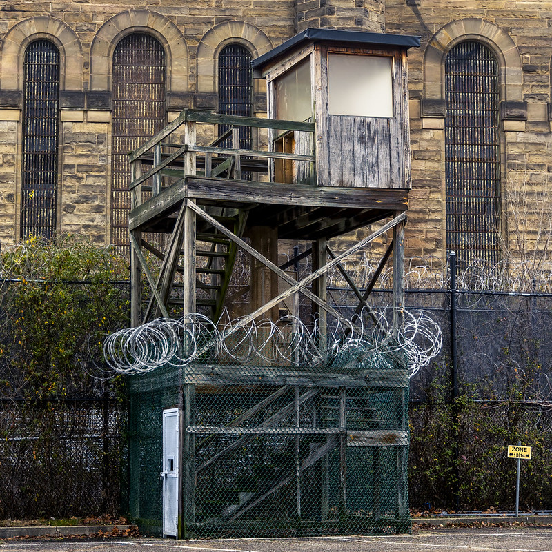
– photo by Mitch Waxman
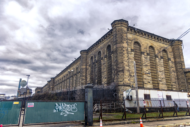
That’s the closed ‘State Correctional Institution – Pittsburgh’ or ‘Western Penitentiary’ pictured above, aka ‘The Wall.’ Founded back in 1826, this counterpart of Philadelphia’s famously haunted ‘Eastern State’ was closed in 2017. A more modern ‘Big House’ called SCI Fayette now houses the Commonwealth’s incarcerated bad boys and girls.
An excellent work up on Western Penitentiary, with enormous attention to historic detail, is found at abandonedonline.net.
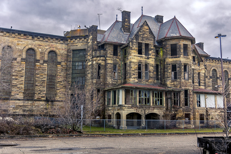
– photo by Mitch Waxman
The trail I was walking on ends nearby the western side of the prison campus, so it made for a convenient turn around point for the scuttle.
My understanding is that infrequent opportunities to photograph the interior of the place do manifest in the form of tours, and a humble narrator intends on attending such an outing (or is it an ‘inning?) when I can. I’ve never been inside a jail, which doesn’t mean I’m a model citizen, rather it indicates that I’ve just never been caught while doing anything really bad.
– photo by Mitch Waxman
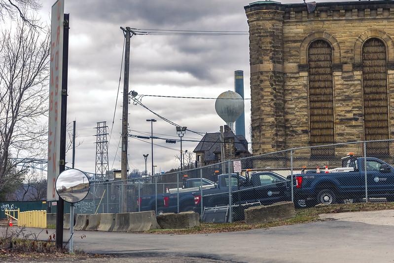
All of these shots were gathered through the stout iron fence surrounding the campus, while following my personal prohibition forbidding trespassing. There was a security guard sitting in a car in the place’s parking lot, but that’s not what dissuades one such as myself from trespass.
I’m like a Vampire, and need to be invited in to do my thing.

– photo by Mitch Waxman
This was a particularly cold and ‘raw’ day. I was wearing longjohns under the normal black sackcloth ‘Mitch Suit,’ and the flapping black raincoat (aka my ‘Street Cassock’) was all I needed for the outer shell.
Another one of the adaptations I’ve had to make since moving to Pittsburgh has involved the purchase of an actual Winter Coat.
I chose one from the Carhartt brand, as it offered several voluminous pockets which zipper close and is of stout construction. Its downy insulation is only needed when it’s going to be freezing or below, I’d add, and it feels a bit like I’m wearing a down comforter when it’s on. Given how warm it is, it’s surprisingly light in terms of weight, which is a plus.
– photo by Mitch Waxman
At my ‘turnaround point,’ and standing in the driveway of the abandoned state prison. I’ve read about several schemes hatched over the years to do something productive with the property. It belongs to the Commonwealth, as in the State, which is something that seems to annoy the municipality level politicians who want to build… ready for it… ‘affordable housing’ on the 21 acre footprint of the place.
It’s funny, but it seems to me, something like this joint should be turned into a museum that explores the history of the carceral state and law enforcement. Apparently the cost of maintenance and in particular heating and cooling the interior of the gargantuan structure is an untenable expense, however.
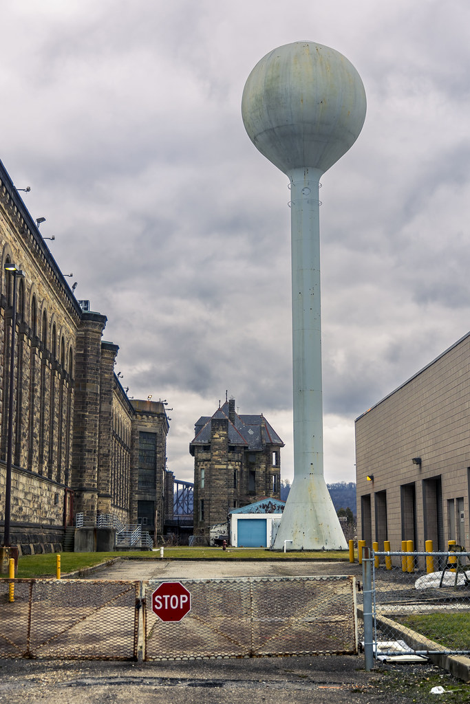
– photo by Mitch Waxman
One began the scuttle back towards the spot which I had parked the Mobile Oppression Platform (my car) in, where this short walk had started from. It gets dark early here, and I wanted to be well on my way home before I had to activate the MOP’s headlamps. It’s about a ten mile drive from this spot back to HQ, if you’re curious.
Back tomorrow with a few odds and ends from this very gray day.
“follow” me on Twitter- @newtownpentacle
Buy a book!
“In the Shadows at Newtown Creek,” an 88 page softcover 8.5×11 magazine format photo book by Mitch Waxman, is now on sale at blurb.com for $30.


