Archive for the ‘Queens Plaza’ Category
Newtown Grafiti
Ms. Heather over at NYshitty recently ran a piece on some interesting runic grafiti found in Greenpoint, Brooklyn. Examination by her extensive network revealed a sinister meaning to the appearance of these runes. Connections to the late 19th century German mystics and conjurers who inspired Hitler’s Wagnerian mythos emerged.
As I’ve ambled across the Newtown Pentacle in the last few years, I too have noticed odd grafiti that hints of esoteric knowledge. My interests and studies have crossed the left hand path more than once, and I have the eye of one acquainted with an iconography of the occult. The Pentacle is steeped in magick all the way back to the Dutch.
This makes sense, as the pastoral shamanism of the Koreans and the ghost worshipping of the Catholics stands cheek by jowl with Nestorian Christianity and the Yesidi clan of Kurdish devil worshippers (here’s one of their holy books- I shit you not). Mohammedan or Hasid, Presbyterian or Hindoo, all the mainstream faiths in the area have thrown great spires at the sky and filled the socratic skyline with their particular “gnosis”. The one thing all these people have in common, other than problems with subway service, is that every one of these churches has its apostates. The Catholics have Opus Dei, and the Muslims have the Sufists.
Groups of true believers who think that the “big church” has lost its way, these philosophies offer hidden truths and revelation. Cults, or as we might say it in modern newspeak- “self organizing grass roots gatherings of religious enthusiasts”. Often, these cults form within gangs. The South American and Mexican gangs, in particular, are known to employ magicians called “Padrinos” to amplify their advantages in hostile encounters. If you believe in magick, it works. They do.
In February of 2009, during a religious ritual in Flushing, a 6 year old was burned with “accelerants”. Invocations of a Loa often involve spitting flaming rum at the intended participant of the ceremony. Santeria (and its black magick equivalent- Palo) also employs similar magickal techniques and symbology.
Also… how does Aleister Crowley always end up getting into the mix? The goetia, which that nasty man said was “the Lesser Key of Solomon” contains ritual sigil designs that are very similar to designs found appearing all over Astoria since mid 2007. A better thing to read, would be this. Seriously, this is the craziest thing you’ll see today. Ok, maybe this is.
If you’re interested in this sort of thing, I would suggest reading up on the Rosicrucians, The Order of the Golden Dawn, Madame Blavatsky and the Theosophists, and the 19th century Spirititualist movement. Compare with the “model tenement” movement, John Harvey Kelogg, and eugenics. The occult inheritances of these debauched philosophies have filtered out into popular culture as Veganism, New Age Movement, Alcoholics Anonymous and the Recovery Movement, and a series of badly spellchecked grimoires which all refer to themselves as “the Necronomicon”.
At the end of the 19th century, occult topics played well in the absinthe fueled cocktail party culture of the middle class- the “sustainable living” and “green technologies” conversations of their day.
First, there is a difference between grafiti and occult markings. These are grafiti.

Ravenswood- This is a “tag”, a kind of grafiti which is painted or etched with differing levels of artistic merit. Often, taggers will “bomb” a neighborhood, leaving behind dozens if not hundreds of iterations of their particular icon. Often the tag will refer to gang or ethnic affiliations -photo by Mitch Waxman

Sunnyside Yards Honeywell Bridge Tag. The top right looks sigili-ish, but the 187 (police code for an undercover cop in trouble) indicates this is New York Street culture oriented -photo by Mitch Waxman

Street work painted by DOT. An amazing coincidental drawing of a theoretical tesseract or hypercube -photo by Mitch Waxman
The next two are Latin Kings tags. No affiliation or hate.

Astoria Latin Kings tag -photo by Mitch Waxman
I hesitate to post anything about… umm… self organizing fraternal societies of urban youth- but these are Latin King tags. The number of points in the crown has some significance which I am ignorant of, the presence of circles amongst the points which indicates political standing or factional allegiances of the tagger to the citywide organization is also something I am completely ignorant about. Go ask a King.

Woodside Latin Kings tag -photo by Mitch Waxman

Dutch Kills abandoned factory: Part of a series of enigmatic scrawls found in a muddy place where no footprints could be seen -photo by Mitch Waxman
Now, either by design or accident of design- the occult::

This is in one of the isolated spots in Long Island City. Similar to Ms. Heather’s runes, these are under the LIE and over the LIRR in Long Island City, behind the midtown tunnel -photo by Mitch Waxman

Mt. Zion altar. Found this on 59th street while walking the Mt. Zion cemetery fenceline. It was a little wooden mortar and pestle with coarse gray ash inside of it. There was candle wax as well -photo by Mitch Waxman

This is a fairly modern, post-industrial era sigil representing the demon Asmodeus. Lamp pole in Astoria -photo by Mitch Waxman

Astoria, chaos dragon/snake mother sigil. Compare with the ancient Naga of the Mahabharata -photo by Mitch Waxman
and another one, miles away in Ravenswood-

Ravenswood Sigil -photo by Mitch Waxman
Obviously the work of a small group or possibly even one person, this next grouping started turning up all over astoria since middle 2007. The one with my shadow in it is in Maspeth, by an abattoir.

Occultish grafiti found along the fenceline of a gigantic Korean Church -photo by Mitch Waxman

Occultish grafiti found in Astoria -photo by Mitch Waxman

Occultish grafiti found in Astoria -photo by Mitch Waxman

Occultish grafiti found in Maspeth -photo by Mitch Waxman

Occultish grafiti found in Astoria -photo by Mitch Waxman

Occultish grafiti found in Astoria -photo by Mitch Waxman

Graphomania like this is all over the place, and gets denser as you travel toward Corona and Roosevelt. Most likely a mexican or ecuadorian fraternal group. Read the text from multiple angles and directions. Correct orientation will be apparent to members. Standard fenceline style of code -photo by Mitch Waxman

Occultish grafiti found in Greenpoint -photo by Mitch Waxman
Of course, Queens being Queens… some things require little or no explanation

Dutch Kills -photo by Mitch Waxman
A Big Dig in Queens
Sorry for the quotidian nature of parts of this post, but if someone says it better and more succinctly than you can- just acknowledge and accredit the source I always say.

Sunnyside Yards, Degnon Terminal- photo by Mitch Waxman
An Observation:
Good old fashioned “Progress” is on the move again in the City of Greater New York.

Sunnyside Yards, from Skillman Avenue- 3 exposure HDR photo by Mitch Waxman
Along the east side in Manhattan, a new subway line is under construction. The project has called for an expansion of the Long Island Rail Road’s cyclopean Sunnyside railyards at the Degnon Terminal here in Queens. (ps- check this video of a ride on the 1950’s Manhattan Third Avenue El at YouTube).
Quoted content from trainsarefun.com
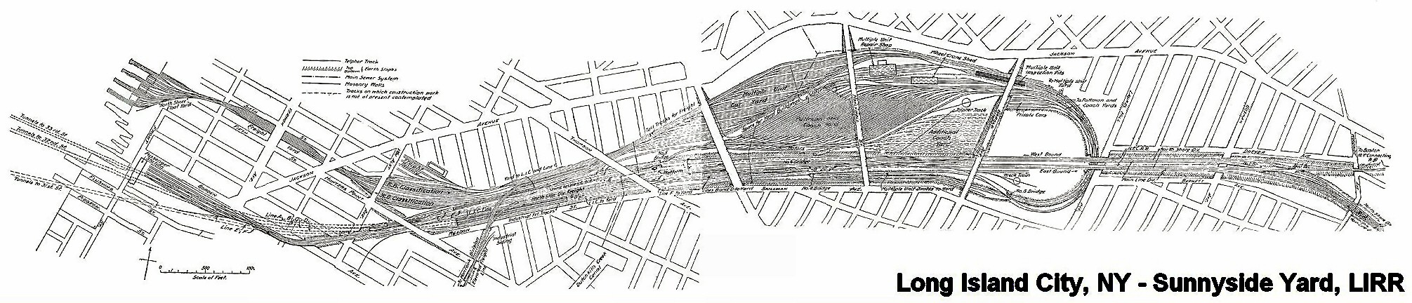
Sunnyside Yard Rendering C. 1905
In 1910 the Pennsylvania Railroad had completed its terminal in New York City, which was connected by tunnels to New Jersey, and under the East River to Long Island. At Sunnyside the large yard of the Pennsylvania Railroad was constructed. An agreement was made with that Railroad and the Pennsylvania Tunnel and Terminal Railroad Company whereby the cars of the Long Island Railroad would be carried through the tunnels under the East River into the Terminal at Seventh Avenue and Thirty-second Street, New York. Thus the Long Island Railroad acquired what successive administrations had striven for in vain, a terminal on Manhattan Island. In order to reach this terminal it was necessary to electrify from Jamaica to New York, which was accomplished in 1910, and the first train run into the Pennsylvania Station on September 10th of that year.
-Felix E. Reifschneider’s 1925 Long Island Rail Road History
I REALLY have to recommend some time spent at Trainsarefun.com for any antiquarian, and especially for the intrepid photographer trying to peel back a few layers. This is one of the best collections of old photos and maps on the Long Island City and Newtown Creek industrial complexes that I’ve found so far. Wow. This is the link to their LIC page (same as one on accredidation).

Sunnyside Yards, Degnon Terminal- photo by Mitch Waxman
The Plan:
as quoted (verbatim) from the wikipedia article on the subject:
Extending between Sunnyside, Queens, and Grand Central Terminal, the East Side Access project will route the LIRR from its Main Line through new track connections in Sunnyside Yard and through the lower level of the existing 63rd Street Tunnel under the East River. In Manhattan, a new tunnel will begin at the western end of the 63rd Street Tunnel at Second Avenue, curving south under Park Avenue and entering a new LIRR terminal beneath Grand Central Terminal.
Current plans call for 24-trains-per-hour service to Grand Central Terminal during peak morning hours, with an estimated 162,000 passenger trips to and from Grand Central on an average weekday. Connections to AirTrain JFK at Jamaica Station in Jamaica, Queens, will facilitate travel to John F. Kennedy International Airport from the East Side of Manhattan.
A new LIRR train station in Sunnyside at Queens Boulevard and Skillman Avenue[1] along the LIRR’s Main Line (into Penn Station) will provide one-stop access for area residents to Midtown Manhattan.[2] The station may spur economic development and growth in Long Island City.
A comment:
Once again, the recurring theme of “spurring development and growth in Long Island City” emerges. Look at the photos here at the Newtown Pentacle, go to our flickr group and see what other people are compelled to record and share. Does this place look undeveloped or undergrown? These are real estate interests talking, trying to grab away what remains of New York’s industrial infrastructure. These buildings are full of companies that employ people in low paying jobs that you don’t need a diploma or even ID to get. Greasy, necessary jobs handling garbage and other things you wouldn’t like to think about. Abattoirs and crematories are part of the story, like sewers and trains, of the greatest metropolis in the history of mankind.

Sunnyside Yards, Degnon Terminal- photo by Mitch Waxman
Minutia:
Degnon Terminal and the Sunnyside Yards are so large and obvious from the air, so critical to the economy and strategic operational capabilities of the United States- that they were designated by the Soviet Union’s Missile Forces as the first strike target in a nuclear attack on the New York Metropolitan area, not Manhattan (which is only a mile and half away, mind you, and would have been obliterated along with the yards).
– I’m trying to back that one up right now, but its something I read a while back- perhaps at conelrad, I’ll find my source on this- I just have to stop looking
-Astoria, incidentally, is where the famous “Duck and Cover” propaganda flick was made (here’s the youtube link).
Astoria and Sunnyside provided a large number of the 16,000 employees who worked here at the Degnon Terminal, almost all of whom belonged to labor unions. These were jobs “with benefits” like health insurance or paid vacations, a rarity before the late 1970’s. The shells of the titanic companies like Adams (Beeman) Chewing Gum, and Sunshine Biscuits line the streets surrounding the yard, but modernity has largely cut their links to it. These industrial buildings- filled piecemeal with dozens of smaller companies- load their containerized goods onto trucks, not trains, and the international port that will ship their products is in Newark, New Jersey.

Sunnyside Yards, this street corner is actually on a bridge over the yards- notice the change in elevation at lower left- still around 30-50 feet (10-15 meters) over the tracks– The structure at horizon is another road bridge over the yards. –3 exposure HDR photo by Mitch Waxman

Sunnyside Yards, Degnon Terminal- photo by Mitch Waxman
An opinion:
These sort of tectonic shifts in the landscape are nothing unusual in New York City, which is not so much a series of individual structures as it is an enormous complex of infrastructure whose every perspective is ultimately centered on Manhattan and whose borders ultimately lie hundreds, if not thousands, of miles away radiating in every direction including out to sea and in the air.

Sunnyside Yards, Degnon Terminal- photo by Mitch Waxman
Here in the Newtown Pentacle, near the very center of this Megalopolis– centuries of power, phone, water, and sewer systems weave around layered building foundations, abandoned trolley lines, and the legacy of the industrial revolution. Deep under the streets, streams and creeks that once ambled over the stubborn hills of New Amsterdam now crash through stone clad sewers in a century clad darkness, mixing with industrial runoff and raw sewage. Even under the best of circumstances, a lot of New York’s untreated waste ends up in the harbor. A significant portion of that dumping, by the City of New York, happens at Newtown Creek.

Sunnyside Yards, Queensboro Plaza Side, also a bridge over the yards- photo by Mitch Waxman
A warning:
In the very near future, vast new residential populations are envisioned to live nearby- at Hunter’s Point, and Queensboro Plaza, and all around the Sunnyside yards, if “growth is spurred”. I’m just an observer, but I’ve watched condo developers carving bloody chunks out of Long Island City, reducing enigmatic and functional structures down to a neighborhood eerily reminiscent of Battery Park City. These new developments are not required to improve the sewers, or build subway stops, or even compel the local electric company to improve the quality of its archaic grid. Can these ancient Newtown foundations support a magnified community they were never designed for?

Newtown Creek Bulkheads- photo by Mitch Waxman
On the waterfront(s), these waters flow into forgotten subterranean vaults, and flow through depression era landfills, swirling through long buried smuggler tunnels and abandoned building foundations on their pathway to the river– silt buried structures which await only the discovery of modernity. All the poisons which lurk in our Newtown mud leech into the water, eventually percolating into the East River and New York Harbor beyond.

Sunnyside Sewer- photo by Mitch Waxman
Who can imagine what might be buried down there, under all the layers of progress, and what the Big Dig in Queens might be stirring up?

Sunnyside Yards, Degnon Terminal- photo by Mitch Waxman
ps: Check out this video at Youtube for sound reasoning on why New York was the center of the universe– it’s Geography!
“Influence of Geography & History on Port of New York 1949”
Queensboro Bridge

Queensboro HDR, originally uploaded by Mitch Waxman.
May 31st- Late in the day, after the Queensboro Bridge Centennial Parade was winding down- I found myself virtually alone on the Queensboro Bridge. Tramway park in Manhattan had free donuts and the Queens side was empty.
The last ferry ran from Greenpoint, Brooklyn to Manhattan in 1933 and the Queensboro Bridge was responsible for the end of regular service. When Adriaen Block (a Dutch navigator who charted parts of New York Harbor and Long Island Sound in the 1600’s) charted the East River, He called it “the River of Sound”. Gustav Lindenthal designed the enormous “geared” structure which opened in 1909.
Its Queens tower is in Ravenswood south of Queens Plaza where its vehicular traffic disgorges. In Manhattan, its locus is 59th street and 2nd avenue. There is also a tower footing on Roosevelt Island, formerly known as Blackwell’s Island.
Home to the insane asylum’s of Nellie Bly’s time, there was once a vehicle elevator that carried trucks and workers down to serve the island’s “hospitals”. Queensboro was referred to as the Blackwell’s Island Bridge for much of its construction.
There is a pedestrian walkway on the lower level that offers spectacular views of Roosevelt Island, Manhattan, and western Queens to the intrepid antiquarian. Watch out for speeding bicycles.
Queensboro sits on the western leg of the Newtown Pentacle, nearly equidistant between Pot’s Cove and Hunter’s Point.


