Millvale scuttle
Wednesday

– photo by Mitch Waxman
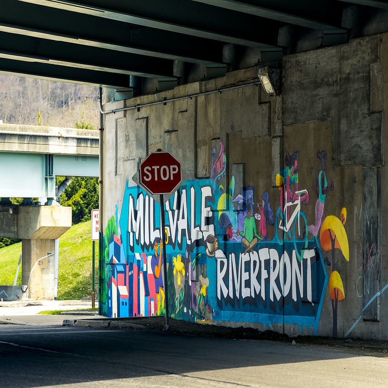
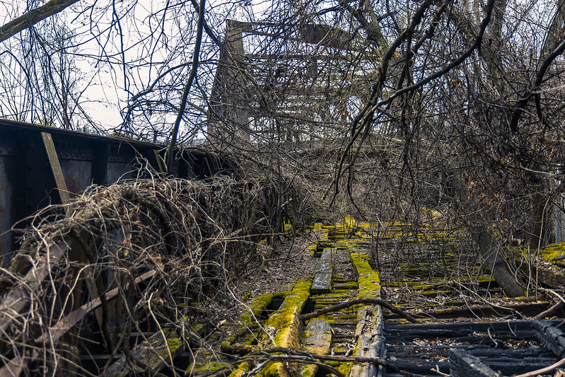
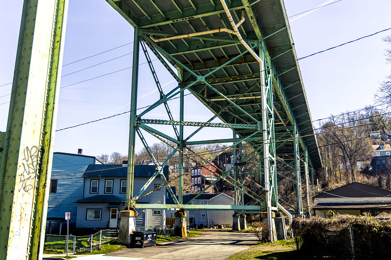
One piloted the Mobile Oppression Platform over to the community of Millvale recently, to check out a ‘river walk’ trail that I’ve had pegged on my Google maps inventory for a while now. This spot is on the north coast of the Allegheny River and just east of Pittsburgh proper. Active rail moves through here, and there’s also plenty of ruined rail infrastructure to inspect as well.
Funny thing is, this was a particularly annoying afternoon for me but that had little to do with the two or three miles of photowalking which I came here to experience. In general, but specifically on this afternoon, the human infestation just sucks the joy out of everything.
People, amirite?
– photo by Mitch Waxman
This trail is a part of the Three Rivers Heritage Trail, a combined bike and pedestrian dealie which snakes all around the Pittsburgh Metro area.
There’s a parking lot, which is where I left the car while walking around – as you’d imagine. When it was time for me to leave, I get into the car and pull out of the spot. Where I pulled out, it’s a marked lane indicating travel in the other direction, which means I needed to cross to the other side of the lot where the intended direction is allowed to travel. Thing is, just as I pulled out of the spot and into the lane, I see these two guys on bikes riding towards me, so I immediately come to a complete stop with the intention of waiting for them to pass before I do anything else.
Now, these two guys – they were the ‘Bro Type’ of bikers. You know these sorts of testosterone monkeys – wearing Oakley mirror sunglasses, bike helmets, the biker’s stretchy shorts, and logo laden silky bicycle shirts. The bike is outfitted with multiple water bottles and gadgets. The sort who talk about riding a bicycle with the thousand mile stare of a combat veteran.
One of them (the apparent Dominar who likely self describes himself as an ‘Alpha’ or ‘Sigma’ male) rides up to my drivers side window, while I’m waiting for them to pass rather patiently – with a sneer on his face – to inform me that ‘it’s one way, asshole’ and then gestures at my rear view mirror in a manner that indicated he was planning on knocking it off the door.
Why are ‘the bicycle people’ always such complete and utter dicks?
Four wheels bad, two wheels good, that’s why. Seriously, their two road bikes probably cost as much as my car did. They were drivers too, obviously, as I saw them unloading their bikes from a rack on the back of a Subaru. I’ll bet you anything that they wouldn’t have sat there patiently waiting for me to pass if I was walking past their car.
When the guy mouthed off at me, I let him know what Brooklyn sounded like, and he seemed shocked by both the depths of my profanity and the revelation which he received about his Mother’s sexual proclivities. Specifically shocking to him was Mommy’s passion for lying down with the beasts of the field, while singing Dixie.
– photo by Mitch Waxman
Closer to home and later on in the day, I found myself merging into a turn lane in the center of the City, something which another driver some four to five car lengths behind me displayed great umbrage over.
A tiny person who was driving a gray Volkswagen, this eidelon of assholes started steady honking her horn at me while throwing up both middle fingers, and unintelligibly screaming hostilities out her car window. This series of behavioral tics were observed in my rear view mirror when she was merely two car lengths away, as traffic compressed behind a red light – which also seemed to upset her. The tirade continued for about two to three miles, until she triumphantly passed me by at a traffic light, with one last middle finger salute offered as she passed. Wow.
Road rage is a really, really weird phenomena and I just don’t understand why the angry humans act as they do. It doesn’t make sense, and why do something so high energy if it isn’t going to achieve anything at all? I mean… there’s traffic and a red light. Why would you accelerate your vehicle if you’re coming up to a complete stop?
It… doesn’t… make… sense…
“follow” me on Twitter- @newtownpentacle
Buy a book!
“In the Shadows at Newtown Creek,” an 88 page softcover 8.5×11 magazine format photo book by Mitch Waxman, is now on sale at blurb.com for $30.
Goldurnit
Tuesday

– photo by Mitch Waxman
Sigh… so… the local transit outfit, which operates the T Light Rail here in Pittsburgh, is called ‘Pittsburgh Regional Transit,’ or simply ‘PRT.’ Compared to the monstrous political patronage outfit and financial black hole back in NYC which calls itself the MTA – PRT is comparatively a small family sized business that runs buses, inclines, and a truly tiny light rail system around the Pittsburgh metro area. The PRT does a better job of all this – with far fewer resources – if you ask me, but they’re still the ‘Gub’mint.’
Recently announced, there’s a series of repair and maintenance projects barreling down the pike towards Pittsburgh. Several of these will specifically affect me, so when PRT announced they were going to stage a public meeting to present on and discuss the situation…
As always: They’d show up with their PowerPoint presentations, and a consolidated ‘This is how it’s going to be’ message. Somebody from the community always has to show up, ignore the social contract of not questioning your betters, and say to them ‘not good enough.’

– photo by Mitch Waxman
I said that I was never going to another Governmental meeting, didn’t I?
I’m done, I said.
Despite that… there I was, with my big mouth flapping open and saying it – “Hi, I’m Mitch Waxman, and…” Before I knew it I was asking how they’d combat decaying headway times during the construction process, and questioning their (highly optimistic and flawed) metrics about the time factor of loading shuttle buses versus the light rail system.
Damn it. The battle with darkness never ends, does it.

– photo by Mitch Waxman
Suffice to say that you’re not going to be seeing shots here of the T running between the end of May and September, and that I’m finally going to be taking a ride on a Pittsburgh bus. Looking forward to checking out the busway system, I am, with its private rights of way separate from private vehicular traffic. That’s the plus, the positive side of things.
The negative is that the summer of ‘24 outage in T service is just the beginning of a long series of projects which are scheduled to play out over a nearly five year interval. Even worse news is that I’m supposed to attend a meeting of the local transit advocacy group, tomorrow night.
Back tomorrow.
“follow” me on Twitter- @newtownpentacle
Buy a book!
“In the Shadows at Newtown Creek,” an 88 page softcover 8.5×11 magazine format photo book by Mitch Waxman, is now on sale at blurb.com for $30.
A Schenley Scuttle
Monday

– photo by Mitch Waxman
After entering Schenley Park via a southern entrance (as described last week), your humble narrator walked along the Junction Hollow Trail. Paved with asphalt, this is a pretty easy walk through a series of sports fields and open meadows of grass. On either side of the urban corridor it moves through, here in Pittsburgh, steep hillsides sprinkled with urbanized residential areas were observed.
Pictured above (I think) is the Charles Anderson Memorial Bridge, which is currently undergoing emergency repairs that were undertaken after the nearby Fern Hollow Bridge collapsed suddenly back in 2022.

– photo by Mitch Waxman
There are rail tracks here (Junction Hollow!), which I’m told were once used as a main line right of way for the B&O Railroad. The rails seem to be polished and shiny, which suggests there’s at least occasional rail traffic here, but I didn’t see any while walking through.
One wasn’t here for rail shots, but I definitely wouldn’t have complained if serendipity struck. Frankly, a bit of serendipity would have been nice at this moment.

– photo by Mitch Waxman
This is where I was heading to, anyway, Panther Hollow and Panther Hollow lake. Manmade, a significant amount of upland storm water drainage is directed towards this body. It, in turn, drains via another water way called Four Mile Run into the Monongahela River.
There were birds and critters, and a bunch of those icehole Canada Geese milling about and despoiling the shoreline with incessant pooping.

– photo by Mitch Waxman
High above, spanning the hollow, is the 1896 vintage Panther Hollow Bridge. This was my turnaround point on the walk, which is nearly always pre-decided upon on during this sort of outing.
I had to backtrack to the car, and reverse the steps which I’d already taken. The park itself was beginning to get populated with college students who were bounding about, jogging, doing yoga stretches – that sort of thing. People… yuck.

– photo by Mitch Waxman
A conversation was started up with some random fella, who was walking his dog, and it turned out that his brother lived in Brooklyn’s Greenpoint so we found some random commonality between us. The guy, and his dog, lived here in the Run and he described the neighborhood’s charms in an effusive fashion.
I bid him adieu, and continued scuttling along back to the car.

– photo by Mitch Waxman
It was late afternoon and time to head back to ‘my neck of the woods’ for… sigh… more on that tomorrow.
I said I wasn’t going to ever do that again… over and over, I said it…
“follow” me on Twitter- @newtownpentacle
Buy a book!
“In the Shadows at Newtown Creek,” an 88 page softcover 8.5×11 magazine format photo book by Mitch Waxman, is now on sale at blurb.com for $30.
Scuttling Hollow
Friday
– photo by Mitch Waxman
While walking through a Pittsburgh neighborhood called ‘The Run,’ one of the first things I noticed and pointed the camera at was the Swinburne Bridge. It’s a 1915 steel girder affair, which carries Frazier Avenue over the ravine which the Run community is embedded into. Clicking that link above will bring you to a page at historicbridges.org, which will tell you all the nitty gritty about it – when, where, who, and why.
I was heading for an area called Panther Hollow in Schenley Park, and was walking there shortly after having parked the Mobile Oppression Platform in a public lot set up for visitors to the network of trails that snake around Pittsburgh.

– photo by Mitch Waxman
A neighboring span carries I-376 (aka Penn-Lincoln Hwy./US Hwy. 22/Hwy. 30) high over the ravine. The entirety of this high speed roadway is a fairly massive structure, which was built in 1956 as part of the Federal Interstate Highway System build out.
I continued on towards the entrance of Schenley Park, where I was happy to find a Porta Potty waiting for me to ‘dewhizzulate.’ I know that it’s odd to constantly mention when and where I took a piss in these posts, but as a lifelong New Yorker… the idea that such public amenities exist at all are still startling to me.
Imagine it… an acknowledgment of human biology… by a government…
– photo by Mitch Waxman
Panther Hollow itself is set into a ravine or valley found between two steep hills which are built out with residential and collegiate buildings. The name of the place comes from the observance of wild Panthers here during the 18th and 19th centuries, critters which are also known as Mountain Lions. Sportsball teams associated with the nearby PITT university use Panthers in their branding, thereby.
Back next week with more from Panther Hollow – at this – your Newtown Pentacle.
“follow” me on Twitter- @newtownpentacle
Buy a book!
“In the Shadows at Newtown Creek,” an 88 page softcover 8.5×11 magazine format photo book by Mitch Waxman, is now on sale at blurb.com for $30.
Run, rabbit, run
Thursday

– photo by Mitch Waxman
Recent endeavor found your humble narrator driving over to a section of Pittsburgh called ‘The Run’ which adjoins Schenley Park. I wasn’t visiting or exploring the community, rather passing through and I was following a trail map which led through the park.
At the nearby end of the Eliza Furnace Trail is found a parking lot, where the Mobile Oppression Platform had been berthed. I should have looked more deeply at the trail maps, as I could have parked a bit closer to my destination, but I’m never one to complain about a bit of extra walking.
That’s Pittsburgh’s Second Avenue pictured above, and the large property on the right is called ‘Blair Park,’ but it used to be part of a Steel Mill (or so I’m told). Still learning about this joint, me.

– photo by Mitch Waxman
Second bends onto Saline Street, which then leads into a neighborhood called ‘the Run.’ There’s a great local YouTube channel, produced by a fellow named Dean Bog, that offers a nice short about this area – check it out here.
Bog’s inventory of videos explore the various communities in the Pittsburgh Metro area, and they impart the ‘vibe’ encountered when exploring the habitations of the local human infestation. Here’s one about the part of town where HQ can be found and where a humble narrator dwells – the Borough of Dormont.

– photo by Mitch Waxman
My goal for the afternoon, beyond getting some exercise and seeing a place which was novel and new, was to get to a spot called Panther Hollow in Schenley Park. The ‘front door’ to this park is nearby the campuses of PITT and Carnegie Mellon University, whereas a ‘back door’ is found down here.
Back tomorrow with more.
“follow” me on Twitter- @newtownpentacle
Buy a book!
“In the Shadows at Newtown Creek,” an 88 page softcover 8.5×11 magazine format photo book by Mitch Waxman, is now on sale at blurb.com for $30.


