possible cure
On the boat.

– photo by Mitch Waxman
As mentioned yesterday, I took a ride on the new Soundview line of the NYC Ferry recently in pursuance of scouting out a tour which I’m going to conduct along its route. Soundview is a long ride by the standards of the new Ferry system, some 46 minutes. It takes you north from Pier 11 Wall Street along the eastern shoreline of Manhattan with stops at 34th street and then at 90th street. Its path carries you along the rather familiar sights of the great bridges section of the East River (Brooklyn to Queensborough) and then proceeds into the River’s west channel between Roosevelt Island and Manhattan.
Pictured above is a tug towing an empty fuel barge southwards along the waterway. How do I know it’s empty? Look at how high the barge is riding in the water… that’s how.

– photo by Mitch Waxman
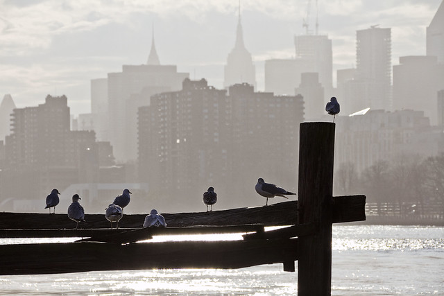
The west channel of the East River is preferred for the passage of larger ships and maritime industrial traffic for a couple of reasons, most notably the absence of height restrictions due to the Roosevelt Island Bridge and the “no wake” zone around the Big Allis power plant in Queens’ Ravenswood section. The Soundview ferry uses this channel to proceed northwards, passing by notable Upper East Side landmarks like Rockefeller University in the East 60’s.
That’s another huge articulated tug and fuel barge in the shot above, operated by the Reinauer company. Articulated means that there are cabling connections which allow the Captain of the tug to operate the two entities as a single vessel. There is also a large cutout notch in the bow of the barge which the tug nestles into.

– photo by Mitch Waxman
Last stop in Manhattan is at East 90th street, whereupon the ferry route heads across the East River to the east channel, and heads into Hells Gate. Those of you with a historical mindset might already have an inkling of what this tour will be talking about, but let’s just say that a little bit more than a century ago on a nice morning in mid June, a large group of people boarded a boat just north of Wall Street at Peck Slip, and more or less followed this route. Things did not go as planned for them, and bad things happened. Very, very bad things.
More tomorrow, at your Newtown Pentacle.
“follow” me on Twitter- @newtownpentacle
outside world
This light of day thing is a real drag.
– photo by Mitch Waxman
About a week ago, I spent the afternoon with one of my professional tour guide chums, specifically Corey from NY Adventure Club. We were scouting out a boat tour that we’re planning for June, one which will take advantage of the new NYC Ferry Soundview route. Soundview starts at Pier 11/Wall Street in Manhattan, visits the 34th street ferry dock, and then heads north along the East River towards its ultimate destination in the Bronx. It was late afternoon when Corey and I boarded the boat, and the back and forth of the trip ate up a couple of hours on a February afternoon. Today’s post shows a few highlight shots of what was observed, and later this week we’ll take a closer look at what you can see while onboard.
The shot above is actually from Astoria’s Ferry dock, which was from the very end of the excursion, when I was on my way back home to HQ.

– photo by Mitch Waxman
As you may have discerned from recent posts, a humble narrator has been experiencing a bit of wanderlust this winter. Desire to see places and things less familiar has been bubbling up, and steps have been taken to accommodate this. One is nothing if not systematic, and long time readers will be able to tell you that the southern sections of NY Harbor – Port Elizabeth Newark, the Kill Van Kull, Gowanus Bay and Canal, the “Great Bridges” zone, Wallabout Bay and the Brooklyn Navy Yard, Bushwick Inlet, Hells Gate, and especially Newtown Creek have received a tremendous amount of attention over the last decade. Simply put, I’ve either had or found the means and ability to get to these places.
Recently, a fascination with the northern expanses has emerged – Flushing Bay and Creek, and the “unknown country” of the Bronx’s southern shorelines. The Soundview Ferry puts some of these places within reach of my lens.

– photo by Mitch Waxman
This week, I’m taking you with for the first ride I’ve taken on the Soundview route NYC Ferry. The wonders you can see…
Additionally, there’s going to be a couple of extra postings coming your way, if you’re subscribed for the email delivery of the Newtown Pentacle. The big project which I’d been working on and referring to throughout the last half of 2018 is finally ready for public consumption, and I’m going to be doing a few extra posts to announce it.
“follow” me on Twitter- @newtownpentacle
recent letters
A day late, and a dollar short.

– photo by Mitch Waxman
Sorry for the single image today, a humble narrator’s scheduling got the best of him and that’s why you’ve got a shot of the 4 entering 59th/Lex instead of a proper post today. Back Monday with some of the interesting stuff I saw while riding the new Soundview Line of the NYC Ferry last week.
“follow” me on Twitter- @newtownpentacle
radical profundity
Wrapping up at Flushing Creek.

– photo by Mitch Waxman
Ignorance is bliss.
As described in prior posts, one found his way down onto the sand at Flushing Creek, which was a fairly intriguing spot. I’ve already made inquiries with one of my paddler buddies about who I have to talk to in order to get on the water in a rowboat or something back here, so stay tuned as the weather gets warmer and the plants start turning green again.

– photo by Mitch Waxman
As also mentioned, I’m trying to stay a bit ignorant about conditions and history back here for the moment, but at first flush there are a very different set of environmental issues hereabouts when compared with my beloved Newtown Creek. Everywhere I looked, there were shellfish clinging to this and that all along the intertidal or littoral zone. My ignorance is willful, as I just want to wander around and take pictures.
Of course, I’m entirely ignorant… about… kinds… of… shellfish… speciation… of… No!

– photo by Mitch Waxman
A lot of the talk centering around the Superfund Rememdiation process on my beloved Creek has discussed the creation of wetland habitat not dissimilar to what’s pictured above. Hopefully, the illegal dumping and wind blown trash won’t be part of the final equation in Long Island City or Greenpoint.
I wonder how long that truss bridge is… how high… average daily traffic… about who built… NO! My ignorance will not be pierced… I refuse!

– photo by Mitch Waxman
Personally speaking, it was actually quite a bit of fun for a humble narrator to see new things, given how much time I devote to chronicling the western end of the Newtown Pentacle. Yes, Flushing has always been on my map, but there’s always been something else to do which is closer to home.
Akkk… is that the Van Wyck… Grand Central… something that ends in a “78”… IGNORANCE!

– photo by Mitch Waxman
My pal Val and I left the beach and proceeded up onto the Northern Blvd. truss bridge leading to downtown Flushing and what, by this point, would be a well deserved and very affordable luncheon meal at a Chinese restaurant in the downtown area.
Even on a weekday winter afternoon, throngs of shoppers were marching about, and the streets of downtown Flushing were quite crowded. The neighborhood BIDS and the Chambers of Commerce of Western Queens could learn a thing or two at the end of the 7 Line, I think. Managers and promoters of dying or moribund commercial strips like Steinway Street – for instance – should study Roosevelt Avenue, and Prince or Main Street. In terms of street level retail activity and abundant small businesses, Flushing is popping. What do I know? I’m largely ignorant.
Down by the water though, it’s the usual story.

– photo by Mitch Waxman
Government owned shorelines with fenced off industrial facilities, too few businesses taking advantage of those precious maritime bulkheads. Has to be all kinds of yuck in the water… Flushing Creek itself is situated at a locus of high speed roads, the 7 line… Arrggggghhhh… I almost just looked up Flushing Creek… NO!
I shall maintain my ignorance… I will not… I…
Back tomorrow with something completely different at this, your Newtown Pentacle.
“follow” me on Twitter- @newtownpentacle
awkward signatures
On the sand at Flushing Creek.

– photo by Mitch Waxman
After having successfully navigated my way to the water’s edge at Flushing Creek through an open gate, a humble narrator (and my pal Val, who was game for this particular caper) proceeded off the concrete and down onto the sand. As mentioned previously, I’m intentionally staying dumb about the Flushing Creek waterway – for now – as it’s entirely novel to me to “know” nothing about something and I want to preserve that as long as possible. It’s philosophic with me, ignorance, and it’s difficult to preserve. Every year, I play my “Super Bowl Challenge,” which is prophylactic in terms of information regarding the big game. I don’t want to know when, where, who… anything. It’s more difficult to know nothing than everything about something these days.
A challenge I’m several years into, as a note, is the Lady Gaga challenge. I know nothing about Lady Gaga other than her name. Never looked at a photo, listened to a song, wouldn’t recognize her if she was sitting next to me. No animosity against the house of Gaga is offered, of course, it’s just extremely challenging to remain completely ignorant of somebody is who apparently a huge pop star – and it’s a challenge I accept. I guess I know she’s a pop star.

– photo by Mitch Waxman
By my standards, which are set to a high bar by that legendary exemplar of urban neglect which is the Newtown Creek, things didn’t look too bad around here. There were all sorts of garbage, dumping, broken pipes like the one above encountered… but… I mean… Maspeth Creek… y’know?
Part of the reason I wanted to come here during the brown and brittle months of the winter, incidentally, involved the lessened chances of encountering biting insects and ticks in particular. Got to imagine that there are clouds of mosquitos and black flies around this spot during the summer months.

– photo by Mitch Waxman
There was some sort of ruggose canvas placed on the shoreline, no doubt an attempt at fighting erosion of the sandy beach. The good news is that said canvas created a hard pack surface which was easy to walk on. We were visiting Flushing Creek at the low tide interval of the daily cycle, so lots and lots of shoreline was revealed.

– photo by Mitch Waxman
Modern day Flushing, with its massive “Hong Kong” style real estate developments, provided a backdrop for the scene. Like LIC, this “other” end of the 7 line in Queens has been growing exponentially in recent years. Manhattan’s Chinatown has been relegated to history’s dustbin, a relic of a forgotten age in NYC. Flushing is where it’s at these days, as far as where Chinese people live and work, and the place is being remodeled according to their tastes and preferences.
The “American Way” at work.

– photo by Mitch Waxman
We proceeded back along Flushing Creek for a bit, and the further that we went in the direction of Roosevelt Avenue, the more marshy the ground became. Brush and grasses became thicker, and salt water streams punctuated the foliage with increasing frequency. The sound of traffic on the nearby highways and area streets were the only non naturally generated sounds, other than the occasional passage of a 7 Line train set on the overhead trackage which carries the subway to and from Flushing’s Main Street.

– photo by Mitch Waxman
There were oodles and oodles of birds flapping around, and I’m sure that at night this part of Flushing Creek would be crawling with Raccons and Rats and all sorts of nocturnal critters doing their thing.
More tomorrow, at this – your Newtown Pentacle.
“follow” me on Twitter- @newtownpentacle
