Posts Tagged ‘Lock and Dam 2’
Scouting in Sharpsburg
Thursday

– photo by Mitch Waxman
Back to the Allegheny River, and my desire to get some photos of the United States Army Corps of Engineers Lock and Dam 2, after diverting away to check out the Highland Park Reservoir. Remote scouting using Google Maps had suggested several locations which might provide a point of view, and an attempt was made to visit them all.
That’s the Highland Park Bridge’s interchange ramp structure, as seen from below, on the south side of the Allegheny River.

– photo by Mitch Waxman
An ice cream shop, closed for the season, had a parking lot set on a prominence which overlooked the river. The shop actually had one of those tourist binoculars things that you pay a quarter to look through set up in the parking lot, along with picnic benches. It was “customers only” but since they were closed and I couldn’t purchase a vanilla cone, photos were gathered instead. That’s the Highland Park bridge again, and the dark shape in the river is the USACE dam.
Simple concrete based modifications to the natural flow of water has long been a potential remedy for Newtown Creek, back in NYC, that I’ve supported. Flow is Newtown’s problem, ultimately. Cheap and simple alterations like fish ladders and fixed crest dams are the way to encourage the laminar movement of water through the system. The City and all the other powers that be favor pumps and other mechanical contrivance instead. If you’ve got to plug it in, you’ve already lost, I always say.

– photo by Mitch Waxman
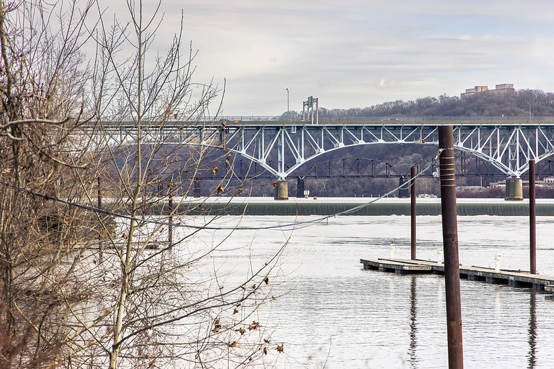
Across the river, in the north shore community of Sharpsburg, one had spotted a marina of sorts which sat on the river side of a railroad trestle. Said trestle is more or less at the center of the shot above. The island at the left side is called Six Mile Island, which I understand as being a nature preserve overseen by the USACE.
One packed up the gear and hopped into the Mobile Oppression Platform (my nickname for the Toyota RAV4), whereupon a quick crossing of the river on the Highland Park Bridge was executed. I soon found myself staring down a series of weathered “No Trespassing” signs at what seems to be a defunct or at least closed for the season boat launch.

– photo by Mitch Waxman
I could probably spend an hour or two just photographing the trestle found there, to be honest. Nitre cloaked, moldy, mossy, dripping… There was a dirt road one could have easily accessed with the MOP (all wheel drive, me) but the fence posts had “posted” signage. It probably would have been a “nothing burger” heading back there, but as is often mentioned – I’m like a vampire, inasmuch as I need to be invited in to do my work. What would Superman do? Answer – the Man of Steel doesn’t knowingly trespass even if he, unlike me, is bulletproof.
People are extremely well armed out here in Western Pennsylvania. There are gun shops in shopping malls, and as the saying goes – if you fuck around, you’ll find out. I intend not to fuck around.

– photo by Mitch Waxman
The trestle carries railroad tracks above it, ones which the Norfolk Southern railroad outfit travel on. Beneath the tracks, it’s a dripping mess, and exactly the sort of post industrial sight that draws somebody like me directly in. As I was completely alone while driving through the thing to get back onto an actual paved road that goes somewhere, I opened the moon roof on the MOP and shot a few exposures on my way out through the roof of the car.
Monday’s post described the recent climate in Pittsburgh, with bands of rain and snow moving through the area, that have been inimical to my pursuits.

– photo by Mitch Waxman
Thereby, given that this particular day out was likely the only opportunity I would have – another system of winter storms was in the forecast – for a few days, I decided to make the most of it and scout out another potential “POV” spot in another community nestled up against the Allegheny. You’ll see that one tomorrow.
More scouting from Pittsburgh and its riverfronts, at your Newtown Pentacle, in Friday’s installment.
“follow” me on Twitter- @newtownpentacle
Buy a book!
“In the Shadows at Newtown Creek,” an 88 page softcover 8.5×11 magazine format photo book by Mitch Waxman, is now on sale at blurb.com for $30.
Lock and Dam too, Allegheny River
Tuesday
– photo by Mitch Waxman
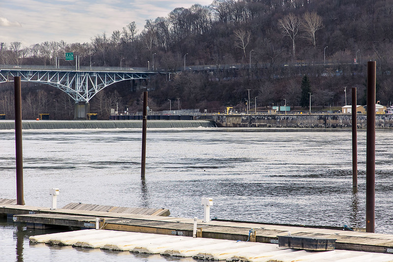
The 1932 vintage Allegheny River Lock and Dam No. 2 (aka Highland Park Lock and Dam) along the Allegheny River drew my interest recently. The St. Patrick’s day flood of 1936 in Pittsburgh, which is part of the same climatological event that drowned nearby Johnstown, resulted in a lot of Federal attention to the rivers surrounding Pittsburgh. The United States Army Corps of Engineers got busy planning a solution after the Flood Control Acts of 1936 and 1938 were passed by Congress. The USACE realized flood control over the Allegheny River after the Kinzua Dam was completed in 1965. Of course, they’ve got three rivers to worry about here (four, actually) and there’s similar USACE infrastructure found on both the Ohio and Monongahela Rivers.
It seems that the USACE design creates about 24 miles of level navigable water on the three rivers, which is referred to as the “Pittsburgh Pool,” and the water level is meant to be some 710 feet above sea level. When a ship navigates into this particular Allegheny River lock, it’s raised or lowered 11 feet from the pool’s altitude depending on direction. There’s a long series of these fixed crest dams and boat locks on the Allegheny River leading all the way back to the Kinzua Dam, which is on the New York side of Pennsylvania’s northern border.
Pennsylvania is wild, man.
– photo by Mitch Waxman
After becoming interested in this sort of infrastructural goodness, I began the usual scouring of Google maps’ satellite views for potential locations from which I could get a look at the thing in action and maybe even set up the tripod for a few “low and slows.”
That sounds bad, doesn’t it? I mean long exposure, tripod mounted landscape shots, not any of the things you could slot “low and slow” into. Aww, that sounds even worse…
“Highland Park Dam Overlook” is what it says this spot is called on Google maps, and after following a Google street view truck’s ride into the area, I decided that this would be the first of several nearby spots where I’d try to find some points of view and maybe the odd natural composition or two.

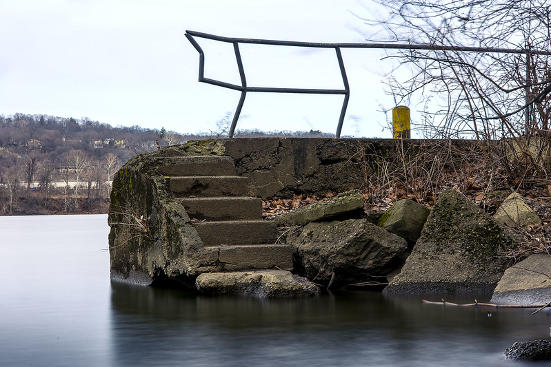
– photo by Mitch Waxman
The furthest out into the water, and the closest clear shot of the Lock and Dam I could get near in this Overlook section, was literally the spot pictured above – on a chunk of what was probably 90 year old concrete sticking out into the Allegheny River. The 1937 vintage bridge in the shot is called the Highland Park Bridge.
I did walk down to the gates of the USACE compound which operates the machinery of the lock, but it was all chain link with barbed wire with security cameras there. I made a mental note to try and charm the pants off of whomever is in charge of this stuff and strive to get some future access for photos from them. I’ve done it before.

– photo by Mitch Waxman
I had to drive a bit of a circuitous route to hit my list of “POV’s,” and since something else that I wanted a look at was found along this route, I diverted away from my lock and dam fever for about an hour. More on that tomorrow.
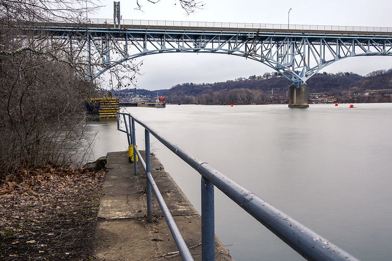
One arrived at another previously remote scouted location for the point of view above after the diversion. That dark line in the water is a fixed crest dam, a concrete structure in the water column which introduces an 11 foot drop in elevation to the Allegheny River. The USACE maintains a minimum depth of nine feet for the Allegheny, it’s deeper in many places, but that’s a lot of water cascading about.
I had a couple of other locations marked down, including a few other potential points of view on the opposite shoreline. I hopped into the Mobile Oppression Platform and crossed the Highland Park Bridge, heading into the community of Sharpsburg.
– photo by Mitch Waxman
Somebody probably wasn’t supposed to be where he was, while shooting these last two shots. Saying that, the property definitely seemed to be out of business or abandoned, but the former occupants left their “no trespassing” signs behind. That’s my story. I pulled the MOP over, cracked out a couple of shots, and then moved on.
The scouting area I’ve been looking at and writing about, since relocating to Pennsylvania, forms a rough circle with circumference points no further than a 30 minute drive from HQ, which is located about 4.5 miles from Downtown Pittsburgh. Using HQ as the center of that circle, I’ve been exploring triangular “pizza slice” sections of the new surroundings, slice by slice. Nerd.
– photo by Mitch Waxman
I was too far away to get a decent shot of it, but right after this shot, a tug and barge appeared and began to navigate into the lock. Wow.
As mentioned, in yesterday’s post, we’ve had a run of wet and snowy weather here in Pittsburgh for the last week. I know this is shocking news for late January. All the shots you’re seeing in this week’s six picture posts were frenetically gathered in a single day. Whew!
More tomorrow, from the Paris of Appalachia, at your Newtown Pentacle.
“follow” me on Twitter- @newtownpentacle
Buy a book!
“In the Shadows at Newtown Creek,” an 88 page softcover 8.5×11 magazine format photo book by Mitch Waxman, is now on sale at blurb.com for $30.


