Posts Tagged ‘Long Island City’
low toned
Holy smokes, the FreshDirect building is toast!

– photo by Mitch Waxman
Just at the point where one traditionally turns back towards HQ and begins the journey from the LIC Dutch Kills “zone,” I suddenly stopped in my tracks at the realization that I could see the sky. The gigantic building with yellow painted corrugated steel walls that used to house the FreshDirect operation here in LIC has been demolished. Tectonic!
This was a HUGE footprint building, five or six stories tall, with both refrigerated and shelf stable warehousing as well as several food preparation workshops. There were interior driveways large enough for multiple semi tractor trailers to reverse into, and smaller loading bays that could handle about ten or so of the FreshDirect local delivery trucks at the same time. Gone.

– photo by Mitch Waxman
Just as an aside for the thousands of people who have interrupted me while photographing over the years to ask “why are you taking pictures of that” while looking at me suspiciously and asking if I like hummus, this is exactly the reason. Creating some sort of record of what was there prior to it being replaced by something new. The “new” thing will have all sorts of government and corporate effort attached to it whose singular goal is the obfuscation of the site’s history. Ask the people in Queens Plaza if they know about the chemical factory, or lead foundry, which used to occupy the site of their shiny new condominium building. That’s the FreshDirect facility pictured above, as seen from a few blocks east.
A big part of the mission here at Newtown Pentacle is to create a record of this era of transition and rapid change in Western Queens for posterity which is independently held and not beholden to the political or business order. Whatever goes up on the site of that FreshDirect building… well… what used to be there?
Glad you asked.

– photo by Mitch Waxman
The big historic factory here was owned by the American Druggist Syndicate, who made pharmaceuticals – so essentially a chemical plant. There were a couple of varnish factories as well, so petrochemical processing. Then a few of the smaller lots were occupied by metal working and refining companies involved mostly in iron working, so that means heavy metals and coal retort residues. The statement above comes from a cursory scan of a 1919 fire insurance map in my possession. Did the 20th century bring in plastics? Garbage handling? Good questions.
Right behind the FreshDirect lot is a set of tracks used by the LIRR which have been liberally doused with rodenticides and herbicides over the centuries, and the soil they sit on hosts lakes of PCB’S, PAH’S and other electrical insulating oils beneath the surface which has bled out of their trackside equipment. Newtown Creek itself is about 2,000 feet away from the Borden Avenue sidewalk pictured in the first shot of this post.
Note: I’m writing this and several of the posts you’re going to see for the next couple of weeks at the start of the week of Monday, March 16th. My plan is to continue doing my solo photo walks around LIC and the Newtown Creek in the dead of night as long as that’s feasible. If you continue to see regular updates as we move into April and beyond, that means everything is kosher as far as health and well being. If the blog stops updating, it means that things have gone badly for a humble narrator.
“follow” me on Twitter- @newtownpentacle
Buy a book!
“In the Shadows at Newtown Creek,” an 88 page softcover 8.5×11 magazine format photo book by Mitch Waxman, is now on sale at blurb.com for $30.
queer noises
Newtown Creek is always fabulous, yo.

– photo by Mitch Waxman
Dutch Kills splits off from the main stem of the Newtown Creek waterway about 7/10th of a mile from the larger water body’s intersection with the East River. Long Island City’s Dutch Kills is a fully canalized tributary, and proceeds on a generally northern trajectory. The water here is highly polluted with both industrial and sewage contaminants. Dutch Kills gets its moniker from the colonial era in NYC history. There’s another tributary of Newtown Creek in Brooklyn called English Kills. Simply, LIC is where the Dutch settled and Brooklyn is where the English put down stakes.
Dutch Kills used to have its own system of tributaries and tidal wetlands, and stretched back (as a navigable waterway) into Queens nearly all the way to Astoria.

– photo by Mitch Waxman
The wooden structures you might notice around bridges are called “Dolphins” and they are usually constructed from creosote treated lumber and galvanized steel rope. The job of these items is to keep a vessel from getting into an allission with the bridge. “Allission” you ask? Yes. That’s when a moving “thing” interacts with a static thing. When two moving “things” interact it’s a collision, so if two vessels were to smash into each other they “collide” whereas if you were to run a vessel up against the dolphin or bridge they would “allide.” Maritime law is quite specific about this.
The dolphins pictured today vouchsafe the 1908 Borden Avenue Bridge.

– photo by Mitch Waxman
Speaking of Borden Avenue, and the “Empty Corridor” thereof which I’ve been walking you through this week, one resumed his westerly course and continued on. That’s when I noticed something missing. Holy Moley!
More on that tomorrow.
Note: I’m writing this and several of the posts you’re going to see for the next couple of weeks at the start of the week of Monday, March 16th. My plan is to continue doing my solo photo walks around LIC and the Newtown Creek in the dead of night as long as that’s feasible. If you continue to see regular updates as we move into April and beyond, that means everything is kosher as far as health and well being. If the blog stops updating, it means that things have gone badly for a humble narrator.
“follow” me on Twitter- @newtownpentacle
Buy a book!
“In the Shadows at Newtown Creek,” an 88 page softcover 8.5×11 magazine format photo book by Mitch Waxman, is now on sale at blurb.com for $30.
horror forcing
The empty corridor.

– photo by Mitch Waxman
Borden Avenue, or at least the section of it pictured in today’s post, was officially designated as such in 1868, after an engineered “plank road” was erected through the swampy low lands surrounding the Dutch Kills tributary of Newtown Creek. It was primarily designed as a commercial corridor, connecting the upland farms and dairies of Maspeth and Woodside with the docks in Hunters Point at the East River. Borden… Borden Milk… Roads were named for where they went back then.
The wetlands of Dutch Kills were filled in at the start of the 20th century, and the railroad took advantage of all the new dry land to hurl spurs out to the various industrial buildings which were erected on the reclaimed flatlands. LIRR still crosses Borden Avenue several times a day at street grade, about a mile west of where these shots were gathered.
The Long Island Expressway truss defines the section of Borden between Greenpoint Avenue and Review Avenue, and the blighted area beneath it is something I refer to as the “Empty Corridor.”

– photo by Mitch Waxman
Dutch Kills itself was rendered into its current form and course at the start of the 20th century, shortly after NYC consolidation in 1898. A huge land reclamation project was being conducted by the Pennsylvania Railroad Company – the creation of the Sunnyside Yards – was occurring about a half mile to the north and west and a construction magnate named Michael Degnon began buying up the wetlands surrounding Dutch Kills from the estate of a former Governor of New York State. Degnon used excavated fill from another one of his projects – the East River subway tunnel which carries the modern day 7 line train – to create dry land around Dutch Kills. Concurrently, the United States Army Corps of Engineers was busy creating industrial bulk heads and “canalizing” the entire Newtown Creek and its tributaries.
That’s the Borden Avenue Bridge pictured, the existing version of which was erected in 1908. It’s not the first Borden Avenue Bridge, but it’s the one that’s stood the test of time.

– photo by Mitch Waxman
While all this tumult and “terraforming” was going on, the Long Island Railroad was investing in the LIC area as well. The Lower Montauk trackage, as it’s known today, connects the Fresh Pond Yard with the East River along the northern shore of Newtown Creek. There are two railroad bridges spanning Dutch Kills. One is DB Cabin, a turnstile bridge which is still quite active but cannot turn or open, and it provides a direct track link between the Blissville and Wheelspur Yards on the lower montauk right of way. The other is Cabin M, which leads to the Montauk Cutoff elevated tracks that formerly connected to the LIRR Main Line tracks at the Sunnyside Yards. Before all this end of the world stuff started, MTA indicated it was going to demolish Cabin M. Somehow, I don’t think that’s happening anytime soon.
As I always say, despite the fact that I call it the “empty corridor” there’s quite a lot going on down here and lots of interesting things to see on a walk in LIC.
Also, on this day in NYC history: The Triangle Shirtwaist Fire occurred in 1911.
Note: I’m writing this and several of the posts you’re going to see for the next couple of weeks at the start of the week of Monday, March 16th. My plan is to continue doing my solo photo walks around LIC and the Newtown Creek in the dead of night as long as that’s feasible. If you continue to see regular updates as we move into April and beyond, that means everything is kosher as far as health and well being. If the blog stops updating, it means that things have gone badly for a humble narrator.
“follow” me on Twitter- @newtownpentacle
Buy a book!
“In the Shadows at Newtown Creek,” an 88 page softcover 8.5×11 magazine format photo book by Mitch Waxman, is now on sale at blurb.com for $30.
alien shadow
Seeing the big rigs in Long Island City.

– photo by Mitch Waxman
One encountered a lonely semi truck on my recent scuttle across a still quite industrial section of LIC. It’s a “class 8” heavy truck, and manufactured by the Kenworth company. “Class 8” are vehicles which serve vocational applications – heavy dump trucks, concrete pump trucks, and refuse hauling – as well as including long-haul 4×2 and 6×4 tractor units such as the one pictured above. Washington state based, Kenworth has been in the truck business since 1912. Don’t ask me to identify what model of truck this is, as I’m sure there’s a gear head reading this who can help with the ID (share in the comments section) and will know far more than I about it. Like taxis and tugboats – when you see a vehicle like this just sitting there parked on the street, the owner is losing money.
I have always been fascinated with this idea of perpetually moving vehicles. Certain vehicles are meant to be operated continuously by multiple crews of drivers, and meant to never stop moving. Police cars and ambulances, subways and trains of all types… cargo ships… all are meant to rest only when undergoing maintenance or changing work crews and operators. That’s interesting, no?
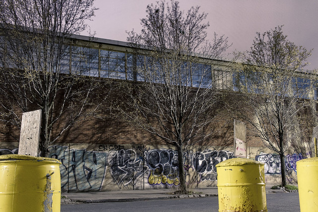
– photo by Mitch Waxman
A graffiti crew had obviously taken fairly recent advantage of the expansive warehouse walls (a “building trade” lumber operation) on this particular block in LIC, but I was more interested in the sickly trees lining the sidewalk than the fairly inexpert tags. In these industrial zones, trees are scarce, and often fall victim to the hustle and bustle of getting things done. In this sort of area, the DEP and FDNY have to erect bollards around their fire hydrants to vouchsafe them from getting knocked over or down, and you’ll often notice utility poles which have had huge swaths carved out of them by careless truckers moving multi ton loads about. Stop signs and lamp posts are regularly snapped off their stanchions as well.
As I tell the people who have just discovered Newtown Creek – all the time – be careful, it’s easy to get dead around here if you don’t know the lay of the land. Luckily, I’ve been obliged to sit through literally days of the safety training which the “union guys” get in order to legally enter job sites and facilities with the camera, and I “sprech the deutch” of their acculturations.

– photo by Mitch Waxman
That’s the Queens Midtown Expressway section of the Long Island Expressway in the upper left, and it’s been towering over Borden Avenue in LIC since 1939. The LIE rises from ground level at Greenpoint Avenue all the way to 106 feet over the waters of Newtown Creek’s nearby Dutch Kills tributary before beginning its descent into the Queens Midtown Tunnel in Hunters Point. I refer to the zone underneath the LIE as “the empty corridor,” but there’s actually quite a lot going on down here.
More from the empty corridor tomorrow, at this, your Newtown Pentacle.
Note: I’m writing this and several of the posts you’re going to see for the next couple of weeks at the start of the week of Monday, March 16th. My plan is to continue doing my solo photo walks around LIC and the Newtown Creek in the dead of night as long as that’s feasible. If you continue to see regular updates as we move into April and beyond, that means everything is kosher as far as health and well being. If the blog stops updating, it means that things have gone badly for a humble narrator.
“follow” me on Twitter- @newtownpentacle
Buy a book!
“In the Shadows at Newtown Creek,” an 88 page softcover 8.5×11 magazine format photo book by Mitch Waxman, is now on sale at blurb.com for $30.
brushed boldly
Industrial zones and pandemics, a natural combination.

– photo by Mitch Waxman
The long walks I take often end up taking me to lonely and deserted places wherein the only other inhabitants of the local vicinity are the drivers and passengers of passing motor vehicles. Now, more than ever, my footfalls lead me and the camera to uninhabited places. There’s a section of Long Island City, west of Sunnyside and north of Blissville, which I’ve always found visually interesting. The land slopes down towards the Dutch Kills Tributary of Newtown Creek, affording one interesting views and an easy perambulation. You’ve always got a real sense of vulnerability here, but intellectually know that at any given moment you’re on half a dozen CCTV security cameras and that there’s a sleep deprived night watchman watching you and hoping that they don’t have to get up and yell at you to stop doing something they are supposed to police. I never trespass, and graffiti ain’t my bag, so…
This section of LIC is interesting in terms of the utilitarian architecture encountered here, some of which is actually quite fetching, but I like a good warehouse or factory.

– photo by Mitch Waxman
Pictured above is a nicely maintained structure found at the corner of 48th Avenue and 34th street, which is currently on sale – based on the Realtor’s banner signage hung on its wall. The 4 story building sits in an M2 industrial zone, hosts 141,000 square feet within its walls, and was erected in 1926 (altered and upgraded in 2013). A little detective work reveals that prior to the renaming of streets and avenues in Queens – and LIC in particular – back in the first half of the 20th century (which happened twice, and is very confusing) 48th Avenue was called “Anable Avenue” and that the factory pictured above was the home of the Morganite Brush Company. Here’s one of their advertisements.
Apparently, Morganite Brush (they’re still around, but call themselves Morgan Advanced Materials these days, and seem to do business from the American South East) manufactured electrical components called “carbon brushes” here. Not wanting to research and write a dissertation on carbon brushes, a quick call to my pal Hank the Elevator guy reveals that “it’s a moving component that supplies voltage to motors” and that he replaces a lot of brushes in the elevator motors he maintains as part of his daily round. Suddenly, the existing modern day profusion of elevator industry supply warehouses and maintenance companies in this section of LIC makes all the sense in the world to me.

– photo by Mitch Waxman
As mentioned, one wasn’t really thinking about a destination and was just following the direction which my toes were pointing towards, while trying to consciously stop myself from wandering anywhere close to congregations of the humans. As is always the case with me, I’d eventually end up at Newtown Creek or one of its tributaries on this particular walk, which you’ve probably guessed by now. Along the way, photos were gathered.
One thing which has really taken my notice is how clean the sidewalks and gutters have become with all of us sequestered away in our hidey holes. Have to figure that the rats and pigeons must be wondering where all the free food has gone.
Note: I’m writing this and several of the posts you’re going to see for the next couple of weeks at the start of the week of Monday, March 16th. My plan is to continue doing my solo photo walks around LIC and the Newtown Creek in the dead of night as long as that’s feasible. If you continue to see regular updates as we move into April and beyond, that means everything is kosher as far as health and well being. If the blog stops updating, it means that things have gone badly for a humble narrator.
“follow” me on Twitter- @newtownpentacle
Buy a book!
“In the Shadows at Newtown Creek,” an 88 page softcover 8.5×11 magazine format photo book by Mitch Waxman, is now on sale at blurb.com for $30.


