Posts Tagged ‘Borden Avenue Bridge’
especially after
Wednesday

– photo by Mitch Waxman
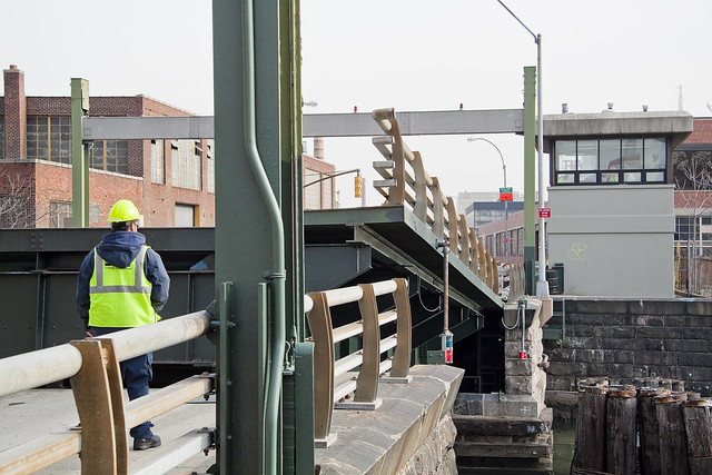
After capturing images of a super saturated sunset in Long Island City, one converted the camera back into its handheld mode and began scuttling towards the train at Hunters Point Avenue. Along the way, something caught my eye at the bridge house for the Borden Avenue Bridge.
There’s graffiti everywhere, but most of the extant paintings are “tags” left behind by “punks.” Every now and then, it’s something different.

– photo by Mitch Waxman
This particular monologue seemed to written in either chalk or grease pencil, and asked several pointed questions. This messaging stood out, and was intriguing.
I did a bit of looking around in response to the curious screed, which led to an internet rabbit hole.

– photo by Mitch Waxman
There’s a small population of people out there who claim that they are being stalked by organized groups, and believe that the group has some sort of connection to shadowy intelligence world entities. Sometimes these groups are governmental, or part of a “globalist cabal,” or they’re connected to some corrupted local branch of law enforcement.
There’s more than one subreddit for “gangstalking” and it’s a “thing.” I watched a couple of videos offered by psychologists who have studied and attempted to treat what they described as a paranoid delusion, and the Docs reported problems with getting these patients to accept help because “the shrink is in on it, and working with the persecutors.” Gang Stalking is described by these medical professionals as a paranoid delusion which is built on top of other psychological pathologies. The bit about “the light” can refer to two things in this world view – one is the weaponry used by the cabal to torture the victim of the gang stalking (said “light” has a variety of effects, from burning the skin to triggering programmed behaviors to somehow surveilling the subject), to the “light of god” as offered by lay priests leading suspect storefront church organizations that offer protection and comfort to the “targeted.”
Disturbingly, several mass shooters (notably the fellow who shot up a Navy Base in Virginia a few years ago) have left behind manifestos that discussed gang stalking as being part of why they did why they did. Most of the people who describe themselves as being “targeted” seem to have a host of other intractable problems – drug addiction, homelessness, mental illnesses. Like I said, “Internet Rabbit Hole.”

– photo by Mitch Waxman
Spotted a cool car as well, while changing the subject.
A late model Ford F-150 pickup.

– photo by Mitch Waxman
Looking north, along Dutch Kills, from the Borden Avenue Bridge towards the Hunters Point Avenue Bridge with the 106 feet over the water Long Island Expressway’s Queens Midtown Expressway Truss framing the shot.
My trick left foot was starting to sing it’s song again, so I started limping towards the train station and a ride back to Astoria.

– photo by Mitch Waxman
More tomorrow – at this, your Newtown Pentacle.
“follow” me on Twitter- @newtownpentacle
Buy a book!
“In the Shadows at Newtown Creek,” an 88 page softcover 8.5×11 magazine format photo book by Mitch Waxman, is now on sale at blurb.com for $30.
joint furlough
Friday

– photo by Mitch Waxman
Back where I belong, like every other piece of wind blown trash in NYC, at Newtown Creek. Specifically, this is the Dutch Kills tributary of the larger waterway, which is found in Long Island City’s Degnon Terminal subsection. This is the turning basin pictured above, wherein one could expect the space required to rotate a tug and barge combination and reverse course back out to the main stem of Newtown Creek and the East River beyond.
What? You think I’m going to purchase a new lens and not bring it here? Pfah. The new lens in question for today’s post is a 35mm f1.8 prime lens.

– photo by Mitch Waxman
The critical factor in purchasing this lens is that it has onboard image stabilization technology, which couples with a different stabilization mechanism inside of the camera body. This combination has been allowing me to pull off handheld shots that I formerly would have needed to use a tripod to achieve. That’s a 1/60th of a second shot above, and the one below is an astounding 1/10th of a second. With my older camera system, I was lucky if 1/80th of a second was possible.
All told, I’m fairly pleased with myself at choosing to invest in the Canon R6 mirrorless system as my primary rig for the next few years.

– photo by Mitch Waxman
As far as “it,” “It” has remained elusive and whereas I’ve hear splashing indications and seen vortexes in the water that indicate something large and heavy had submerged itself, even after several months of looking for “it” I haven’t been able to produce any documentation of “It.”
If “It” is down there, I will get eventually get a shot of it. Just a matter of time and patience, and time spent at the water’s edge here in the heart of the Newtown Pentacle.
Note: I’m writing this and several of the posts you’re going to see for the next week at the beginning of the week of Monday, February 1st. My plan is to continue doing my solo photo walks around LIC and the Newtown Creek in the dead of night as long as that’s feasible. If you continue to see regular updates here, that means everything is kosher as far as health and well being. If the blog stops updating, it means that things have gone badly for a humble narrator.
“follow” me on Twitter- @newtownpentacle
Buy a book!
“In the Shadows at Newtown Creek,” an 88 page softcover 8.5×11 magazine format photo book by Mitch Waxman, is now on sale at blurb.com for $30.
roughly be
LIC.

– photo by Mitch Waxman
More time has been spent in the last two months around the Dutch Kills tributary of Newtown Creek than anywhere else in walking distance, barring my fortress confine back in Astoria, by a humble narrator. It’s deserted here, but for the small armadas of very fast and very loud cars being driven about the empty streets by area youth. They’re blasting around, playing truly awful music (that auto tune crap has to go), but what do I care? Can’t imagine how awful it must be to be young, dumb, and full of quarantine during this interval. I’ve been noticing one of my teenage neighbors straining against her inclination to be vivacious and out in the world. Not my problem, ultimately.
As far as the shot above, there’s a reason I call this particular stretch of LIC “The Empty Corridor.” My big problem at the moment revolves around empty pockets, as in the absence of cash money. Tick tock, tick tock. Ringle tinkle, coins when they mingle…

– photo by Mitch Waxman
I won’t bore you with another posts about the particular peregrinations of photographic settings and techniques utilized in the production of these shots, but suffice to say that you’re looking at a lot of button pushing and parameter dialing embedded into those pixels. Hey… when you’ve got the time to rethink how you do things, come up with new methods and experiment, it would be foolish not to take advantage of opportunity,
Pictured are the ruins of the Irving Subway Grate Iron Foundry, overflown by the Queens Midtown Expressway section of the larger Long Island Expressway.

– photo by Mitch Waxman
That’s the Borden Avenue retractile Bridge pictured above, looking westwards across Dutch Kills towards midtown Manhattan.
As stated in the past, one continues to eschew areas which can be constituted as being heavily populated, given that we are all living in what’s essentially a random number generator as far as getting sick with Covid 19 goes. Precautions, when moving around in my well populated neighborhood, are routinely taken. Sensible usage of a face mask and the regular washing of hands are religiously observed. When I leave the area, and enter these unpopulated industrial zones, the mask comes off and one can breathe free.
Well, as free as you can breathe at a Federal Superfund site, at any rate.
Note: I’m writing this and several of the posts you’re going to see for the next week at the beginning of the week of Monday, May 18th. My plan is to continue doing my solo photo walks around LIC and the Newtown Creek in the dead of night as long as that’s feasible. If you continue to see regular updates as we move into April and beyond, that means everything is kosher as far as health and well being. If the blog stops updating, it means that things have gone badly for a humble narrator.
“follow” me on Twitter- @newtownpentacle
Buy a book!
“In the Shadows at Newtown Creek,” an 88 page softcover 8.5×11 magazine format photo book by Mitch Waxman, is now on sale at blurb.com for $30.
horror forcing
The empty corridor.

– photo by Mitch Waxman
Borden Avenue, or at least the section of it pictured in today’s post, was officially designated as such in 1868, after an engineered “plank road” was erected through the swampy low lands surrounding the Dutch Kills tributary of Newtown Creek. It was primarily designed as a commercial corridor, connecting the upland farms and dairies of Maspeth and Woodside with the docks in Hunters Point at the East River. Borden… Borden Milk… Roads were named for where they went back then.
The wetlands of Dutch Kills were filled in at the start of the 20th century, and the railroad took advantage of all the new dry land to hurl spurs out to the various industrial buildings which were erected on the reclaimed flatlands. LIRR still crosses Borden Avenue several times a day at street grade, about a mile west of where these shots were gathered.
The Long Island Expressway truss defines the section of Borden between Greenpoint Avenue and Review Avenue, and the blighted area beneath it is something I refer to as the “Empty Corridor.”

– photo by Mitch Waxman
Dutch Kills itself was rendered into its current form and course at the start of the 20th century, shortly after NYC consolidation in 1898. A huge land reclamation project was being conducted by the Pennsylvania Railroad Company – the creation of the Sunnyside Yards – was occurring about a half mile to the north and west and a construction magnate named Michael Degnon began buying up the wetlands surrounding Dutch Kills from the estate of a former Governor of New York State. Degnon used excavated fill from another one of his projects – the East River subway tunnel which carries the modern day 7 line train – to create dry land around Dutch Kills. Concurrently, the United States Army Corps of Engineers was busy creating industrial bulk heads and “canalizing” the entire Newtown Creek and its tributaries.
That’s the Borden Avenue Bridge pictured, the existing version of which was erected in 1908. It’s not the first Borden Avenue Bridge, but it’s the one that’s stood the test of time.

– photo by Mitch Waxman
While all this tumult and “terraforming” was going on, the Long Island Railroad was investing in the LIC area as well. The Lower Montauk trackage, as it’s known today, connects the Fresh Pond Yard with the East River along the northern shore of Newtown Creek. There are two railroad bridges spanning Dutch Kills. One is DB Cabin, a turnstile bridge which is still quite active but cannot turn or open, and it provides a direct track link between the Blissville and Wheelspur Yards on the lower montauk right of way. The other is Cabin M, which leads to the Montauk Cutoff elevated tracks that formerly connected to the LIRR Main Line tracks at the Sunnyside Yards. Before all this end of the world stuff started, MTA indicated it was going to demolish Cabin M. Somehow, I don’t think that’s happening anytime soon.
As I always say, despite the fact that I call it the “empty corridor” there’s quite a lot going on down here and lots of interesting things to see on a walk in LIC.
Also, on this day in NYC history: The Triangle Shirtwaist Fire occurred in 1911.
Note: I’m writing this and several of the posts you’re going to see for the next couple of weeks at the start of the week of Monday, March 16th. My plan is to continue doing my solo photo walks around LIC and the Newtown Creek in the dead of night as long as that’s feasible. If you continue to see regular updates as we move into April and beyond, that means everything is kosher as far as health and well being. If the blog stops updating, it means that things have gone badly for a humble narrator.
“follow” me on Twitter- @newtownpentacle
Buy a book!
“In the Shadows at Newtown Creek,” an 88 page softcover 8.5×11 magazine format photo book by Mitch Waxman, is now on sale at blurb.com for $30.
correlated causeways
Eleven bridges, one creek.

– photo by Mitch Waxman
Pulaski Bridge is the first span you encounter, when you’ve left the East River and embarked on a journey down the fabulous Newtown Creek. A double bascule drawbridge, and electrically powered, the Pulaski Bridge connects 11th street in Long Island City with McGuinness Blvd. to the south in Brooklyn’s Greenpoint. Built in 1954, the Pulaski Bridge is owned and operated by the New York City Department of Transportation or “NYC DOT.” The Pulaski Bridge carries five lanes of traffic, plus a dedicated bicycle lane and a separate pedestrian pathway. It overflies the Queens Midtown Tunnel and Long Island Expressway, as well as active railroad tracks found on Borden Avenue.

– photo by Mitch Waxman
DB Cabin acts as a gatekeeper to the Dutch Kills tributary of Newtown Creek. It’s a railroad swing bridge owned by the Long Island Railroad, and connects two rail yards – the Wheelspur Yard (to the west, or left in the shot above) and the Blissville Yard – across the water. Both rail yards and the bridge itself are part of the LIRR’s Lower Montauk tracks. DB Cabin dates back to the 1890’s and is in a terrible state of repair. The swing bridge’s motors are nonfunctional, which isolates the Dutch Kills tributary from maritime traffic, and from the rest of the Newtown Creek.

– photo by Mitch Waxman
Cabin M is just to the north of DB Cabin on Dutch Kills, and the single bascule drawbridge connects the Montauk Cutoff with the Blissville Yard mentioned above. The Montauk Cutoff is an elevated track which used to provide a connection between the LIRR’s Main Line tracks at the nearby Sunnyside Yards with the Lower Montauk tracks along the north (or Queens side) shoreline of Newtown Creek. The 2020 Capital Plan just released by the Long Island Railroad’s owner – The MTA – includes funding to demolish Cabin M.

– photo by Mitch Waxman
Borden Avenue Bridge is owned by the NYC DOT, and is one of just two retractile bridges in NYC (the other being the Carroll Street Bridge over the Gowanus Canal). Built in 1908 to replace an earlier wooden drawbridge (1868) at the intersection of Borden Avenue and Dutch Kills, Borden Avenue Bridge received extensive upgrades and structural repairs in 2010 and 2011, and had its electronic components destroyed by flooding during Hurricane Sandy. Another round of repairs and upgrades began in 2019, which included asbestos abatement work.

– photo by Mitch Waxman
The Long Island Expressway is 71 miles long, and is operationally managed in three sections. The Queens Midtown Expressway is how it’s owners, the New York State Department of Transportation, refer to the section found between the Queens Midtown Tunnel and Greenpoint Avenue in Long Island City. This section is elevated, rising to 106 feet above the waters of Dutch Kills. The LIE truss pictured above handles some 87.7 thousand daily vehicle trips, or 32 million annually, to and from Manhattan,
– photo by Mitch Waxman
Hunters Point Avenue Bridge is due north west of Borden Avenue Bridge and the LIE truss. It’s a single bascule drawbridge, owned by the NYC DOT. Replacing an earlier wooden draw bridge that was opened and closed by a donkey walking on a wheel, the Hunters Point Avenue Bridge was built in 1910. Back then, it was a double bascule bridge, but a rebuild in the 1980’s simplified the mechanism to a single bascule. The masonry of the bridge is original to the 1910 design.

– photo by Mitch Waxman
The Greenpoint Avenue Bridge is found some 1.37 miles from Newtown Creek’s intersection with the East River, and roughly a half mile from the mouth of Dutch Kills. It’s a double bascule bridge, built in 1987, and owned and operated by the NYC DOT. There have been many Greenpoint Avenue Bridges, dating back to the first one built by Greenpoint’s town father Neziah Bliss back in 1850, but that one was called the “Blissville Bridge.” The Greenpoint Avenue Bridge is a traffic machine, carrying 28.3 thousand vehicle trips a day, or about ten million a year. Most of that traffic takes the form of heavy trucking.

– photo by Mitch Waxman
The brand new Kosciuszko Bridge(s) replaced a 1939 vintage truss bridge that carried the Brooklyn Queens Expressway over Newtown Creek and are found some 2.1 miles from the East River. The NYS DOT is busy putting the finishing touches on the new cable stay bridge’s construction. In addition to the… ahem… high speed traffic lanes of the BQE, there is also a pedestrian and bicycle pathway found on the new Kosciuszko Bridge which connects 43rd street in Queens’s Sunnyside section with Meeker Avenue in Brooklyn’s Greenpoint.

– photo by Mitch Waxman
The Grand Street Bridge is a swing bridge connecting Maspeth’s Grand Avenue in Queens with East Williamsburg/Bushwick’s Grand Street in Brooklyn. 3.1 miles back from the East River, in a section of Newtown Creek once called “White’s Dock,” the NYC DOT have recently announced plans to replace this 1909 beauty – which is actually the third bridge to occupy this spot. Damage from Hurricane Sandy, and the narrow roadways with height restrictions that the bridge offers, have pretty much sealed its fate. It will be missed.
This is where the main spur of Newtown Creek ends, as a note. Directly east is a truncated tributary called the East Branch, and another tributary called English Kills makes a hard turn to the south just before you encounter Grand Street Bridge.

– photo by Mitch Waxman
Metropolitan Avenue Bridge is a double bascule drawbridge that crosses the English Kills tributary of Newtown Creek, and is owned by the NYC DOT. Metropolitan Avenue was originally built as a private toll road in 1813, and the first bridge here was a part of the “Williamsburg and Jamaica Turnpike.” The current Metropolitan Avenue Bridge was built in 1931, although it has received significant alterations in 1976, 1992, 2006, and again in 2015. The 2015 alterations?
You guessed it, Hurricane Sandy strikes again.

– photo by Mitch Waxman
Montrose Avenue Rail Bridge is the final crossing found over the waters of Newtown Creek and its tributaries. Some 3.7 miles back from the East River, it’s the property of the Long Island Railroad and used for freight service on their Bushwick Branch tracks. A truss bridge, or trestle if you must, my understanding of things are that whereas the trackway and parts of the rail bridge date back to approximately 1924… there has been quite a lot of work done on the thing which I have not been able to fully document so rather than fill in blanks with assumptions – I’m just going to say that I don’t know everything… yet.
It’s an active track, it should be mentioned.
“follow” me on Twitter- @newtownpentacle
Buy a book!
“In the Shadows at Newtown Creek,” an 88 page softcover 8.5×11 magazine format photo book by Mitch Waxman, is now on sale at blurb.com for $30.


