Posts Tagged ‘queens’
An Oil spill… in Queens

– photo by Mitch Waxman (February 16, 2009)
Sadly, oil is seeping out of a bulkhead on the Queens side of the Newtown Creek.
Famously, the Greenpoint Oil Spill (click here for a link to newtowncreekalliance.org for more) occurred just across the water from this spot, but every indication points to this as being a separate event. The former site of Charles Pratt’s Queens County Oil Works, which was an approximately 18 acre parcel which would later be called the “Standard Oil Blissville works”, the sites occupation in modernity has little or nothing to do with petroleum.
Welcome, by the way, to Newtown Creek- and to the “Blissville Oil Spill”.
Just a note: For the purposes of this posting, I’m departing from the normal formatting, and the photos are presented along with the dates upon which they were captured.

– photo by Mitch Waxman (September 14, 2008)
My practice for the last several years has been to shoot everything I see along the Newtown Creek, whether or not it seems significant at the time. This practice evolved out of the paucity of photographic documentation of the place which survived the 20th century, and the effort has been made with the notion of leaving behind something for future researchers to work with. As time has gone by, and my technological capabilities have expanded, I’ve developed quite a library of shots.
The photo above depicts the site in question during the autumn of 2008, and shows the historic condition of the bulkheads.

– photo by Mitch Waxman (September 14, 2008)
A standard codex for interpreting what one sees along the Newtown Creek states that wooden bulkheads are 19th century, reinforced concrete dates from the early to mid 20th, and steel plating is late 20th and early 21st century. This rule is not “scientific” but allows one to approximate the manufacture of these fallen docks to a relative time period. As you can observe in the shot above, the risible decay of the wooden bulkheads, and their manner of construction, speak to a long period of disuse and lack of maintenance as far as September of 2008.

– photo by Mitch Waxman (February 20, 2010)
In the winter of 2010, a crew began to install modern steel plating along this frontage, which drew my interest. Again, anything that is in a state of flux along the waterway is a point of interest for me. This project went on for several months, and was conducted from a barge with a small crane installed on it.

– photo by Mitch Waxman (February 4, 2011)
By the same period a year later, in February of 2011, the modern installation was complete. Conflicting reports on this style of bulkhead are often heard. The older wooden structures offer a structure for biological organisms to nest and shelter, but “slow” the already tepid flow of water through the narrow passages of the Creek. The steel ones “quicken” the flow, but offer no toeholds for organic life.
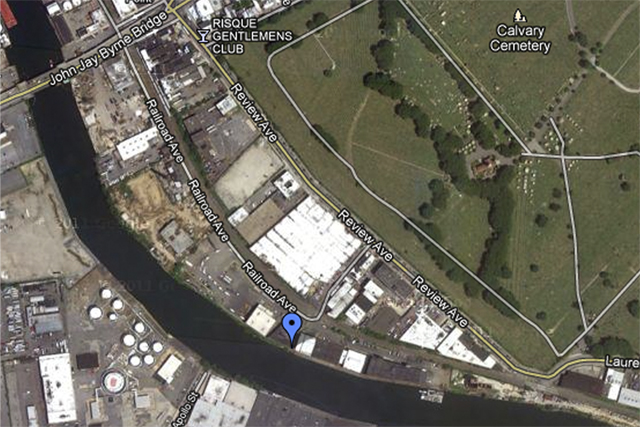
Modern day, (December 2011) google maps screen capture, click here or the image above for the dynamic google map. This is an industrial cul de sac today, accessed by a private driveway. The companies which use this space are largely waste management oriented, warehouse operations, furniture refinishing, or other truck based businesses. Despite the presence of freight tracks through the middle of the site, few of these companies utilize their sidings. Calvary Cemetery and the Kosciuszko Bridge loom large and distinguish the area.

1924 view of the area, screen capture from “NYCityMap” at nyc.gov.
The oil tanks in the center of the site betray the presence of the “Queens County Oil Works” of Charles Pratt, which were also known as the “Standard Oil Blissville Works”. Blissville, of course, is the historic name of this part of Queens which was once a residential area.

Clear plans of the area in 1936 overlaid with the 1924 aerial projection from NYCityMap. Click here to see a large version of the overlay.

Detail view of the area, click here for larger incarnation. The works were here as late as 1951, but at this point, I still haven’t been able to confirm the date they were closed down.

– photo by Mitch Waxman (August 6, 2011)
In the summer of 2011, I was tasked with photographing a “Bulkhead Survey” which members of the Newtown Creek Alliance were conducting. The good folks at Riverkeeper volunteered to take our party out on the Newtown Creek onboard their patrol boat, and when we were passing by the former Queens County Oil Works, we noticed the presence of both containment booms on the water and petroleum product flowing freely from the shoreline itself.

– photo by Mitch Waxman (August 6, 2011)
The theory which has been advanced by knowledgeable sources is that when the steel bulkheads were installed, a process in which the plating is slid down into place and then secured, and that a sealed chamber or buried pipeline was likely ruptured during the construction process which freed “the product”.
I have been asked to mention (by Newtown Creek Alliance and Riverkeeper itself) that investigation of the situation is underway, and the State and City officials responsible for policing this sort of thing are fully and enthusiastically engaged in the process.

– photo by Mitch Waxman (August 6, 2011)
The story of Charles Pratt, his “Astral Oil”, and their involvement with John D. Rockefeller’s Standard Oil Trust will be discussed in a later posting on this subject, as the lengthy history would divert attention from this otherwise serious issue. Suffice to say that the Blissville works were some 18 acres in size, and suffered several “total loss” fires in the late 19th century.
Note that this is a distinct property (and event) from the adjacent State Superfund site which is referred to as the Quanta Resources site.

– photo by Mitch Waxman (November 19, 2011)
Again onboard a Riverkeeper patrol, this time in November of 2011, the overt visual presence and subtle aroma of petroleum was encountered. The black and yellow structure is what is known as a hard boom, and is designed to contain surface contamination and “floatables”. It extends to a few inches below the surface.

– photo by Mitch Waxman (November 19, 2011)
The steel plating at the site is painted with oil, undoubtedly splashed up by wave action during storms at high tide. The white objects which are saturated with petroleum products are absorbent booms, designed to wick up the free floating product.

– photo by Mitch Waxman (November 19, 2011)
The leaves in the shot above are literally stuck into the gluey residues of the oil. You can see the high tide mark left by the water on the cleaner bulkhead which is just beyond the hard boom. Perhaps this is the source of oil, which many have reported to me over the course of the last year, which has been witnessed as it floats toward the East River.

– photo by Mitch Waxman (November 19, 2011)
It is not news that there are environmental contaminants floating freely in this troubled waterway, nor is there any revelation to be found in the fact that petroleum products are commonly observed pooling and flowing about the Newtown Creek watershed.
What is news is that this is in Queens.

– photo by Mitch Waxman (August 6, 2011)
Much of the attention, and deservedly so because of the large and growing population of Greenpoint and Williamsburg, which Newtown Creek receives is all about Brooklyn. The north shore of the Creek in Queens is often left out of discussion (and from both remediation and environmental benefits funding) because of its relatively tiny population and industrial character. One of the questions which this blog has asked since day one has been “Who can guess all there is, that might be buried down there?”.
In the case of the Blissville Oil spill, the question might as well be “How much there might be?”.

– photo by Mitch Waxman (November 19, 2011)
This is just the beginning of a new Newtown Creek story, the tale of the Blissville Oil Spill. I fear it will be the first of many such stories, as we move into the Superfund era.
foetid darkness

– photo by Mitch Waxman
On Monday the 5th of December, the Newtown Creek Alliance had drawn me from the safety of Astoria to the wild streets of Brooklyn and far off Williamsburg’s Graham Avenue. I decided to walk, as the mists had begun to swirl. When the meeting ended, certain Greenpoint based members of the Alliance offered me a lift as far they were going and I gladly took their offer.That’s how I ended up on the Pulaski Bridge in the middle of an astounding weather event.
In the photo above, what is missing from the shot of Newtown Creek is Manhattan.
from wikipedia
Fog is a collection of water droplets or ice crystals suspended in the air at or near the Earth’s surface. While fog is a type of stratus cloud, the term “fog” is typically distinguished from the more generic term “cloud” in that fog is low-lying, and the moisture in the fog is often generated locally (such as from a nearby body of water, like a lake or the ocean, or from nearby moist ground or marshes).

– photo by Mitch Waxman
Even the nearby spires of Tower Town in Long Island City were obscured, lost in some primal soup. The sound was eerie, as well, and our Lady of The Pentacle (who is British) informs me that her countrymen would often remark that sound doesn’t travel the same way through fog as it does in clear air and great caution should be exercised when moving around in it.

– photo by Mitch Waxman
Looking toward Dutch Kills along Borden Avenue, which trails along the malefic Newtown Creek, the enormous advertising sign mounted upon the “Fresh Direct” facility (which recently was, but I’m not sure if it still is, the nations largest illuminated sign) was creating quite a lightshow in the mist.

– photo by Mitch Waxman
This thing plays through several advertisements for the Internet green grocer, and spotlights key products and offers to passing drivers on the Long Island Expressway, which it towers above. Depending on when in the repeating reel of ads you were, the mist either looked like this…

– photo by Mitch Waxman
…Or like this!

– photo by Mitch Waxman
Additionally, here’s one from earlier in the day, at Maspeth Creek, looking toward the Kosciuszko Bridge.
cherished pet

– photo by Mitch Waxman
On one of my walks, as I was crossing from Dutch Kills (the neighborhood, not the waterway) into Astoria via a disreputable corridor shunned by most area wags, these festively adorned bicycles were observed. I can’t tell you a deep story about them, describe some dire and hidden meaning, or point to some occult connection to old world evils or even jungle born horror- knowledge of which which would cause our civilization to retreat into a new and everlasting dark age of ignorance.
All I can do is congratulate the elaborate whimsy of such contrivance.

– photo by Mitch Waxman
Long has my personal palette been described as gloom ridden, dark, and wholly unsaturated. A preference for black clothes, constructed of decidedly coarse and “non shiny” fabric, has often been shown by your humble narrator. Display of such ostentatious pageantry makes me uncomfortable, breaks my confidence, and scares me just a little bit. Can’t tell you why, but it does.
Colorful pomposity might draw attention and inspection upon me from peers and passerby, something which never goes well for me, as cracks in my facade yawn wide.
hewn rudely

– photo by Mitch Waxman
Recently, your humble narrator was onboard a speeding vessel as it hurtled down the River of Sound (or East River as it’s known to modern residents). Turning from the jewel like facade of the Shining City called Manhattan, my thoughts turned to Long Island City and it’s burgeoning Tower Town neighborhood, known to ancient residents as Ravenswood and Hunters Point.
High above and distant from the water I was traveling across, an impression nevertheless grew in my mind that the monocular thing which cannot possibly exist in the spire of that Sapphire Megalith turned and fixed its gaze upon our tiny craft- an intuition of which of I am certain.
from “Laws of the State of New York, Volume 2“, 1870, courtesy google books
AN ACT to incorporate Long Island City.
Passed May 6, 1870; three-fifths being present
The People of the State of New York, represented in Senate and Assembly, do enact as follows:
TITLE I.
Section 1. All that part of the town of Newtown in city the County of Queens, included within the following boundaries, to wit: Beginning at the mouth of Newtown creek, on the east side of the East river, running thence easterly along the center line of said Newtown Creek to the westerly side of the Penny bridge (so called); thence northerly along the westerly side of the Bushwick and Newtown turnpike to the road on the southerly side of Calvary cemetery, known as the road to Dutch Kills; thence along the center of said last-named road on the southerly and westerly sides of Calvary cemetery as far as the boundaries of said cemetery extend; thence northerly along sajd cemetery to the center of the road leading to Green Point, on the northerly side of said cemetery; thence along said last-mentioned road to the intersection of the same with the road leading from Calvary cemetery to Astoria; thence easterly to the center of Woodside avenue ; thence northerly along the center line of said avenue to Jackson avenue; thence northeasterly along the center of the Bowery Bay road to low water mark in Bowery bay; thence westerly along low water mark to the East river; thence southerly along low water mark in the East river, to the place of beginning, shall be a city known as Long Island City; and the citizens of this State, from time to time inhabitants within the said boundaries, shall be a corporation by the name of “Long Island City,” and as such may sue and be sued, complain and defend, in any court, make and use a common seal and alter it at pleasure; and may receive by gift, devise, grant, bequest or purchase, and hold and convey, such real and personal property as the purposes of said corporation may requite.

– photo by Mitch Waxman
The reputation endured by Long Island City in the 19th and most of the 20th centuries can hardly be described as desirable, as the historical record displays. The ancient home of graft, as it has been called, the hybrid assemblage of distant villages and towns into a single municipality which occurred in 1870 spawned a seemingly lawless community.
Tales of gambling dens, vice ridden hotels and inns, foreign born highwaymen, and an endless series of corrupt political organizations abound in contemporaneous accounts of the place.
from “Wallace’s monthly, Volume 8 By John Hankins Wallace“, 1882, courtesy google books
Ever since the enactment of the law against pool selling the police and judicial authorities of this city have been more or less persistent and successful in their attempts to suppress this form of gambling. Whatever charges of negligence and connivance may be brought against them, their services have been valuable and in a measure successful. This is evident from the fact that this particular form of gambling has been driven across the river into Queens County, Long Island, where the dirty scoundrels and their victims congregate to transact their nefarious business. Their protection there, by the local authorities, has been so thoroughly and even fiercely exposed by the daily press that an honest man don’t like to be seen crossing the ferry to Hunter’s Point, or Long Island City, as it is called. In the public estimation the place has become a moral lazaretto and in a choice of residence a man would not have much to choose between that and a smallpox hospital. But why should all this odium lie cast upon poor little tax ridden and rogue ridden Long Island City?

– photo by Mitch Waxman
It is said that when Manhattan outlawed bare knuckle boxing, barges with rings and bleachers upon them appeared at Hunters Point and ferries would carry crowds from the larger city to so called “pugilist exhibitions”. Additionally, according to Comstock and other guardians of the public good, when horse parlors and pool betting (the modern day numbers racket) were similarly banned in the Shining City- a flurry of such activity began across the river at what we moderns would call Long Island City. All of this increasingly organized crime was nourished and populated by the transient customers of the Long Island Railroad and a concurrent Ferry station- again, I’m owing this to period reports from reliable (and multitudinous) sources.
Of course, in LIC, it was the mayor, coroner, police chief, and fire department who both (personally) owned and operated the back room casinos, whorehouses, and dens of iniquity. The LIRR bosses cared little, as long as local government did not get in their way, and the payoff demands were reasonable. It was only during the era of Patrick Gleason that things got out of hand and the LIRR finally had enough of it.
from Wikipedia
Gantry Plaza State Park is a state park on the East River in the Hunter’s Point section of Long Island City, in the New York City borough of Queens.
The 10-acre (4.0 ha) park first opened in May 1998 and was expanded in July 2009. The southern portion of the park is a former dock facility and includes restored gantry cranes built in the 1920s to load and unload rail car floats that served industries on Long Island via the Long Island Rail Road tracks that used to run along 48th Avenue (now part of Hunter’s Point Park). The northern portion of Gantry Plaza State Park was a former Pepsi bottling plant.

– photo by Mitch Waxman
The days of the Rail bosses secretly pulling the strings here are long gone, their proudest achievements reduced to show pieces for the slavering pet of that thing which cannot possibly persist in the Megalith. Cherished and nurtured beneath the unblinking and fire sheathed eye of that which does not breath, nor sleep, yet hungers- this coagulation of industry and greed which it nurtures here is a tangled knot of labor unions, land speculators, and ambitious politicians. This pet- a drooling hound of limitless appetite and vainglorious aspiration has no name- but its malice and cold desire is clearly manifest in Tower Town and will soon spread along the waterfront south across Hunters Point and then into Brooklyn and beyond…
Allegorical references to “Fenrir the Wolf” would seem appropriate, but would be inaccurate- an ancient nomen for a modern threat…
For now, can we just refer to the force trapped behind the black gates of Western Queens as the “Real Estate Industrial Complex“?
from “A history of Long Island: from its earliest settlement to the present time, Volume 1” 1902, courtesy google books
It is noticeable that some of the deeds in the early part of the last century conveying lots at Hunter’s Point call it Long Island City. It continued to be a straggly, dreary, povertystricken place, with few settlers and these of the poorest class, until the Long Island Road, because it could not make the necessary arrangements in Brooklyn, selected it as the main terminus of the road. Since then it has steadily increased in population, and as the First Ward of Long Island City it rapidly assumed the lead in the destinies of that now happilv departed shade. Railway and manufacturing interests have steadily built up its population and added to its material resources, most of which, however, were mercilessly squandered by political intriguers.
a Newtown Creek Alliance meeting

– photo by Mitch Waxman
Newtown Creek Alliance Meeting – 12/5
When: Monday, December 5th, 6:00pm
Where: Williamsburg Community Center, 195 Graham Ave, Brooklyn
The Newtown Creek Alliance will be meeting to to discuss Creek matters. Everyone is welcome. We will be discussing the next steps in the Superfund cleanup process, the progress of the Brownfield Opportunity Area plan, NCA’s educational programming, green infrastructure and green jobs at Martinez Playground, and forming working groups on bioremediation, solid waste, and education.