far within
A bright, light, sunshiney day, in Today’s Post.

– photo by Mitch Waxman
Recently, the Federal NOAA agency placed a plaque at Bushwick Inlet’s U.S.S. Monitor Museum site, signifying the launch site of the United States’ first ironclad war ship from the spot in Greenpoint. One made it a point to arrive early, there was an event planned which involved dignitaries speaking and children singing, and take a bit of time to get “artsy – fartsy” with the camera and grab some shots.
– photo by Mitch Waxman
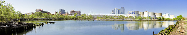
The one above is a stitched panorama, representing around 200 degrees of view. Just to the right of center are some of the big condo buildings in Williamsburg, and at far right are the tanks of Bayside Fuel.

– photo by Mitch Waxman
That’s Franklin Street on the other side of the fence, btw, behind an overgrown fence line which one didn’t explore except with a zoom lens.

– photo by Mitch Waxman
There was, indeed, a duck of some kind there.

– photo by Mitch Waxman
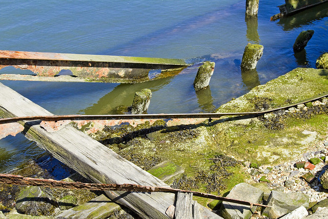
Rotting timbers found in the littoral zone, which look quite a bit different than the ones you’ll find along my beloved Newtown Creek. These are green and teeming with life, as the East River is actually quite a bit cleaner here than in its northern tributary.

– photo by Mitch Waxman
There were lots of rusty bits sticking up out of the ground, but heck – this used to be Continental Iron Works after all.

– photo by Mitch Waxman
Continental Iron Works, in addition to building the Monitor, also fabricated the caissons of the Brooklyn Bridge here.
– photo by Mitch Waxman
Most of this stuff doesn’t date back to the 1860’s, obviously, there’s a large MTA warehouse and workshop on the landward side and this was the industrial coast of North Brooklyn. Nothing laid fallow here until pretty late in the game – the 1960’s at the very earliest. The experts on this site are George and Janice from the Greenpoint Monitor Museum, who can tell you all about it here.

– photo by Mitch Waxman
My interest in Bushwick Inlet is Newtown Creek oriented, of course. The historical definitions of the wetlands surrounding my beloved Creek always mention Bushwick Creek (here) to the south, and Sunswick Creek (Hallets Cove) to the north.
The area between Newtown and Bushwick Creek was called “the Cripplebush,” which is a fun fact.

– photo by Mitch Waxman
Looking past the mouth of Bushwick Inlet, one finds the Freedom Tower, rising from the LeCorbusier inspired NYCHA housing which rings the Shining City.
“follow” me on Twitter- @newtownpentacle
Upcoming Tours –
June 20th, 2015
Kill Van Kull Walking Tour
with Brooklyn Brainery, click here for details and tickets.


Leave a comment