Posts Tagged ‘Bushwick Inlet’
far within
A bright, light, sunshiney day, in Today’s Post.

– photo by Mitch Waxman
Recently, the Federal NOAA agency placed a plaque at Bushwick Inlet’s U.S.S. Monitor Museum site, signifying the launch site of the United States’ first ironclad war ship from the spot in Greenpoint. One made it a point to arrive early, there was an event planned which involved dignitaries speaking and children singing, and take a bit of time to get “artsy – fartsy” with the camera and grab some shots.
– photo by Mitch Waxman
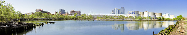
The one above is a stitched panorama, representing around 200 degrees of view. Just to the right of center are some of the big condo buildings in Williamsburg, and at far right are the tanks of Bayside Fuel.

– photo by Mitch Waxman
That’s Franklin Street on the other side of the fence, btw, behind an overgrown fence line which one didn’t explore except with a zoom lens.

– photo by Mitch Waxman
There was, indeed, a duck of some kind there.

– photo by Mitch Waxman
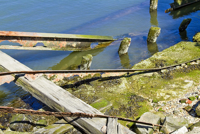
Rotting timbers found in the littoral zone, which look quite a bit different than the ones you’ll find along my beloved Newtown Creek. These are green and teeming with life, as the East River is actually quite a bit cleaner here than in its northern tributary.

– photo by Mitch Waxman
There were lots of rusty bits sticking up out of the ground, but heck – this used to be Continental Iron Works after all.

– photo by Mitch Waxman
Continental Iron Works, in addition to building the Monitor, also fabricated the caissons of the Brooklyn Bridge here.
– photo by Mitch Waxman
Most of this stuff doesn’t date back to the 1860’s, obviously, there’s a large MTA warehouse and workshop on the landward side and this was the industrial coast of North Brooklyn. Nothing laid fallow here until pretty late in the game – the 1960’s at the very earliest. The experts on this site are George and Janice from the Greenpoint Monitor Museum, who can tell you all about it here.

– photo by Mitch Waxman
My interest in Bushwick Inlet is Newtown Creek oriented, of course. The historical definitions of the wetlands surrounding my beloved Creek always mention Bushwick Creek (here) to the south, and Sunswick Creek (Hallets Cove) to the north.
The area between Newtown and Bushwick Creek was called “the Cripplebush,” which is a fun fact.

– photo by Mitch Waxman
Looking past the mouth of Bushwick Inlet, one finds the Freedom Tower, rising from the LeCorbusier inspired NYCHA housing which rings the Shining City.
“follow” me on Twitter- @newtownpentacle
Upcoming Tours –
June 20th, 2015
Kill Van Kull Walking Tour
with Brooklyn Brainery, click here for details and tickets.
unfortunate lunatic

– photo by Mitch Waxman
Selected for your perusal today are scenes from the hoary desolation of Brooklyn’s Bushwick Inlet.
This little bay, where the USS Monitor was launched some 150 years ago, was the river outlet for Continental Iron Works. In addition to the Monitor, countless steam boats, and the manufacture of all manner of cast iron building supplies- the caissons for the Brooklyn Bridge were assembled and launched here.
The Brooklyn street grid indicates Calyer and Clay streets as being the nearest geographic indicators, but there’s something else missing.

– photo by Mitch Waxman
Bushwick Creek once flowed into and mingled with the East River at this spot after finishing its journey from upland. The city of Williamsburg listed this body of water as its border with the town of Greenpoint, which itself was defined and named for a promontory bluff overgrown with hemlock that existed between the Newtown and Bushwick Creeks.
The hemlock was what originally attracted shipwrights here, as the straight growing evergreens produced wood that had several uses onboard ships.

– photo by Mitch Waxman
The inlet is owned by Motiva Enterprises, a company with several locations in the area which employs itself as a fuel distributor. Accordingly, access to the area is severely limited due to security and safety issues. These shots were acquired during the Greenpoint Monitor Museum‘s recent parade event. The northern side of the site is in a state of disuse and relict decay, while the southern houses several enormous fuel tanks.
There is some buzz that the Museum is attempting to site themselves here, a welcome addition, IMHO.

– photo by Mitch Waxman
Scatterings of artifacts, a brick marked “Manhattan Fire Brick Co.”, or a rust stained concrete foundation peek out of the mud here and there. The very surface you stand on is crumbling, and at waters edge all sorts of uncommented masonry sits in a tumbledown arrangement as the languid waters of the East River nibble away at the shoreline.
The muddy soil is a greasy particulate, more sticky sand than dirt, oddly irridescent and stained with “the colour” which distinguishes the nearby Newtown Creek.

– photo by Mitch Waxman
Across the river in Manhattan, which today hosts the Stuyvesant Town housing development and a power plant, there were shipyards. Novelty Iron Works as well as hundreds of smaller shops were spread out between 14th street and Corlears Hook (just below the modern day Williamsburg Bridge). In the late 19th century, Stuyvesant Town’s site was occupied by shanty tenements and the enormous “works” of the gas system which lit Manhattan streets and homes- I’ve seen references to it as the “gas light district”.
As one got closer to 23rd street, stone masons and other artisan businesses began to appear.

– photo by Mitch Waxman
When a large business concern like Continental Iron Works or Novelty sited somewhere, it created a halo of smaller businesses springing up around it. Coopers to make barrels, carpenters to supply barrel wood, blacksmiths to make carpentry tools. Rope makers, lunch wagons, carting companies- all surrounded these large plants. Greenpoint was no different, with enormous numbers of storefront and stable based craftsmen supplying everything from pencils to livestock to the larger concerns.
Additionally, ferries and streetcar lines were required to transport workers and raw materials from place to place.

– photo by Mitch Waxman
Disuse, changing economies, and the unusual indifference which the 20th century displayed toward the waterfront of New York City have left this historic patch of land a wasteland. Indigenous species or a mollusca invader from foreign shores, all have claimed a rightful place here, planting strong roots which slither into and spread apart the forgotten brick foundations of long ago and way back when.
Who can guess, all there is, that might be buried down there?

– photo by Mitch Waxman
Here in the foundry of the American Industrial Revolution, all we manufacture these days are Red Velvet Cupcakes and other items of fashionable taste.
Stronger men, born in an age of sail, forged a world of steel and iron in this place. A vibrating hum of industry lit the smoky sky with coal fired avarice, forging the great fortunes of some and the prosperity of most. Where are these titans today, with their great and satanic mills, and what happened to “Coketown“?
Also:

Your humble narrator will be narrating humbly on Friday, February 24th at 7:30 P.M. for the “Ridgewood Democratic Club, 60-70 Putnam Avenue, Ridgewood, NY 11385” as the “Newtown Creek Magic Lantern Show” is presented to their esteemed group. The club hosts a public meeting, with guests and neighbors welcome, and say that refreshments will be served.
The “Magic Lantern Show” is actually a slideshow, packed with informative text and graphics, wherein we approach and explore the entire Newtown Creek. Every tributary, bridge, and significant spot are examined and illustrated with photography. This virtual tour will be augmented by personal observation and recollection by yours truly, with a question and answer period following.
For those of you who might have seen it last year, the presentation has been streamlined, augmented with new views, and updated with some of the emerging stories about Newtown Creek which have been exclusively reported on at this- your Newtown Pentacle.
For more information, please contact me here.
ironclad
– photos by Mitch Waxman
It was 150 years ago today, that John Ericsson taught the band to play.
Shots from the Greenpoint Monitor Museum parade, held yesterday, celebrating the launch of the USS Monitor 150 years ago today. Not entirely sure what role Llamas played in the Civil War, of course, but their presence was quite welcome.


