Walking widdershins to Calvary
feel like taking a walk? I’ll show you something cool… Bring your camera- and ID
Anything you may experience, in situ, by following these walking directions is at your OWN RISK, and is offered by the Newtown Pentacle for documentary and entertainment purposes only. Remember- the rule we follow at the Newtown Pentacle is to NEVER trespass. Like Vampires, Newtownicans should wait to be invited into a house before they can do their work. Also, Please note — if something you read here is inaccurate, DO NOT BE SHY- contact me– additions and corrections are always welcome at the Newtown Pentacle.
Over Hill and Dale part 3- Widdershins around Calvary

-photo by Mitch Waxman
Click here to preview this photowalk in a google map
Hunters Point avenue intersects with the ancient course of Greenpoint Avenue at the degenerate extant of Long Island City. The Queens Midtown Expressway also comes back down to earth here, feeding Manhattan vehicular traffic to all points east. This is a very busy intersection, so be mindful of traffic, as fellow pedestrians are rare.
As with anyplace else in Queens you’d want to see, Forgotten-NY has been through here before. Click here for their page on Blissville and Laurel Hill.

-photo by Mitch Waxman
St. Raphael’s R.C. Church is on Greenpoint Avenue in a neighborhood called (atavistically) Blissville. A wooden frame building was built for St. Raphael’s in 1867, and served as the mortuary chapel for the newly built Calvary Cemetery. The current gothic influenced structure was completed in 1885, and has served both Calvary and the surrounding community since. This is one of the highest points in these parts, and the church steeple often acts as a reference point when negotiating the byzantine tangle of streets around the Newtown Creek. The architect is rumored to have been Patrick Keeley.

-photo by Mitch Waxman
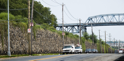
Walk past a gas station (last chance for water or gum) on your right, and you’ll be at the corner of Greenpoint and the Queens Midtown Expressway. To your right is Manhattan, and the elevated phase of the Queens Midtown Expressway which carries vehicular traffic over Long Island City and the Dutch Kill. That’s Borden Avenue down there, under the elevated highway. Don’t worry, I’m taking you there in a few weeks. Today, we walk widdershins around the dead.

-photo by Mitch Waxman
Dead is what you’ll be if you don’t pay attention when crossing this street. Luckily, where we’re heading- you’ll fit right in. This may be a good time to remind you of a Newtown Pentacle posting from a few weeks back- “The Cemetery Belt“.
Quoting from James Riker Jr.’s “Annals of Newtown” – from Brooklyn Genealogy
CALVARY CEMETERY. This cemetery, which is located at Laurel Hill, was set apart and consecrated in 1848. It is one of the most accessible rural cemeteries near New York, and it would be difficult to select a lovelier or fitter spot as a place of sepulture. The old ground comprised one hundred and ten acres, but in 1853 a charter was obtained from the State by the trustees of St. Patrick’s cathedral, New York city, for 250 acres; 165 acres of this are now enclosed. The artesian well in that part of the enclosure called New Calvary was sunk in 1879. It is 606 feet deep and 6 3/4 inches in diameter, and was bored in white granite for a large part of its depth. Last year 32,000 persons died in the city of New York, and of this number 15,500 were buried in Calvary. The cemetery keeps one hundred and fifty men regularly employed, and two hundred more are kept at work by the relatives and friends of the deceased. Here may be found some of the choicest of materials and the finest models in monumental structure; and here we may mention as worthy of note the vault and chapel built by John Johnston, at a cost of $75,000, and regarded as one of the finest to be found in any ground. This cemetery is to the Catholics of New York what Greenwood is to the Protestant population. Since 1872 Hugh Moore has been the general superintendent, and to his ability much of the beauty and attractiveness of the place is due; he has been assisted by Michael Rowen. The mortuary chapel, of fine architectural design and finish, was built in 1856. The present chaplain is Rev. M.J. Brennan.

-photo by Mitch Waxman
The shadowed lanes of Calvary await your hungry eyes, but we are not entering the necropolis today, dear reader. Instead, we’re lurking around its nitre dripping fenceline, scuttling along the broken pavement and visible cobblestones of Greenpoint Avenue to the corner of Bradley Avenue, where we will turn widdershins (left).

-photo by Mitch Waxman
Click here for a Wikipedia page on Calvary Cemetery, to familiarize yourself with the story of this extraordinary place and the people who chose this as their final address.
To the modern mind, the Greenpoint Ave. gates of Calvary are the obvious main entrance to the place due to their proximity to the highway- but the actual street address of Cavalry is at 49-02 Laurel Hill Blvd.- which is on the Newtown Creek side (we’re going there, don’t worry). When this place was built, the Newtown Creek was the central artery of the surrounding communities, not the barrier that modernity has made of it.
Often, as I am out exploring these areas (in the early 21st century), I’m asked by neighborhood people- members of a long abused community which is wary of strangers – what I’m up to. I’ll explain my interest in the area and then be asked “What’s Newtown Creek?” by people who live in Greenpoint or Long Island City. Manhattan people think you’re just making it all up- they say “how can that be? You’re exaggerating” when you tell them about this place.
If members of “the community” aren’t even aware that the Creek exists, how can we ever hope to coerce our political class to address its many problems? Please, bring your cameras down here and peek under a few rocks yourself. Tell the story of this place.

-photo by Mitch Waxman
Bradley Avenue is truncated by the iron fencelines of Calvary, and we’re going to follow the dead end here, onto 37th street. I often wonder, when the fences of Cavalry are closed, what sort of things transpire in this lonely place.

-photo by Mitch Waxman
As we proceed down 37th street, the street elevation begins to drop down toward the Newtown Creek shorelines, but Calvary remains at the same grade level as Greenpoint avenue.

-photo by Mitch Waxman
A lonely industrial block, 37th street also hosts several homes of taste and substance near its intersection with Review Avenue. We turn widdershins again, to the left on Review.

-photo by Mitch Waxman
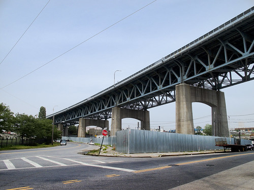
At the corner of Review, looking to your right, is the Greenpoint Avenue Bridge. Greenpoint people will find this a pleasant crossing over the Newtown Creek and a reference point for negotiating this lonely part of Long Island City.
-photo by Mitch Waxman
On Review Avenue, the wall of Cavalry looms. That’s the Kosciuszko bridge in the background. The cyclopean scale of Cavalry is apparent here, and behind that masonry lie the dead.

-photo by Mitch Waxman
As you continue down Review Avenue, you’ll be passing the old LIRR Penny Bridge station at the corner of Review and Laurel hill Blvd.

-photo by Mitch Waxman
Now dear readers, this is your first revelation of a master plan behind the Newtown Pentacle. I am willing to reveal that everything is connected. This corner is where the post “Dead Ends, A short walk from Maspeth to Calvary” ends. That post picked up where “the Wrong side of the tracks, a walk in Maspeth” ended. Turn Widdershins on Laurel Hill Blvd.
-photo by Mitch Waxman
The big problem you’ll have, however, is that there isn’t really a functional sidewalk here on Laurel Hill Blvd. I’m quite used to this sort of thing at this point, so…

-photo by mitch Waxman
Commanding views of Calvary can be had here. The elevation rises, and St. Raphael’s comes into view.

-photo by Mitch Waxman
As you proceed, on the other side of the BQE will be a heavy manufacturing zone with relict housing interspersed. The area has an aura of long time municipal neglect.

-photo by Mitch Waxman
At the end of Laurel Hill Blvd, you will find a pedestrian bridge which is covered in a tightly woven chain link fence. Except for this spot, at tripod height, that was cut by some photographer in the past. The same person (same cut pattern and size) was also nice enough to cut a hole in the fence on the Pulaski Bridge.


[…] a comment » We’ve circled and stalked the place from the street, when we “Walked Widdershins to Calvary“. In the first full posting on Calvary, we walked from Laurel Hill Blvd. into the Necropolis […]
Up and Through Calvary « The Newtown Pentacle
August 8, 2009 at 1:28 pm
[…] the Long Island City side, Review Avenue takes you to venerable Calvary, and Greenpoint Avenue out to bucolic Sunnyside, and Van Dam to the frenetic Queens Plaza. But- […]
Greenpoint Avenue Bridge « The Newtown Pentacle
August 10, 2009 at 12:14 am
[…] Cross 36th street at Hunters Point Avenue and Continue all around Calvary Cemetery in “Walking Widdershins to Calvary“ […]
Astoria to Calvary 5- the bitter end « The Newtown Pentacle
August 28, 2009 at 4:00 am
[…] spire of St. Raphael’s on Greenpoint Avenue, sentinel church to Old Calvary- can be glimpsed through the steel. That is also where the highway […]
Long Island City Zen 2 -The Empty Corridor « The Newtown Pentacle
September 1, 2009 at 3:01 am
[…] Walking Widdershins to Calvary […]
Calvary Cemetery Section « The Newtown Pentacle
December 19, 2009 at 3:36 pm
[…] Am I overestimating? Check out this shot from the “street level” declination, aimed at the downward slope from halfway down Review Ave.- […]
Tales of Calvary 10- The Hatch « The Newtown Pentacle
January 27, 2010 at 5:14 pm
[…] of mourners replete with musicians and baroque carriages- would use to travel to Calvary Cemetery. A posting from July of 2009, Walking Widdershins to Calvary, explored Review Avenue and the surrounding area in some small depth. Industrial footprints are […]
the hillside thickets « The Newtown Pentacle
March 4, 2010 at 6:48 pm
I remember walking through Calvary with my mom.
Maria Nahmias
July 4, 2010 at 12:01 pm
[…] just happened to be passing St. Raphael’s on Greenpoint Avenue on Saturday the 14th of August, and found this splash of color illuminating […]
St. Raphael’s « The Newtown Pentacle
August 17, 2010 at 9:50 am
[…] St. Raphael’s and its congregants provided me with one of the best “just stumbled upon it” photo days I’ve ever experienced here in Western Queens. Check out this Flickr album from 2010. […]
blazed effulgently | The Newtown Pentacle
April 5, 2022 at 11:00 am