adhered to
Grand Street Bridge, in today’s post.
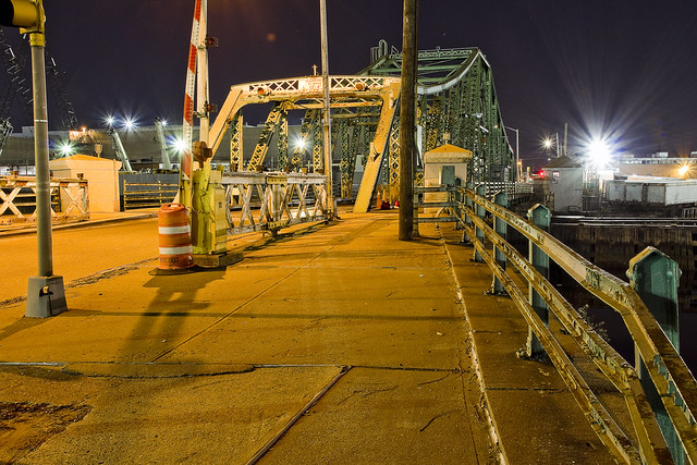
– photo by Mitch Waxman
Before you ask, no, I won’t be talking about Amazon HQ yet. Suffice to say that everybody I know is talking about the news co-announced today by the Dark Prince of Albany and the Dope from Park Slope that the internet giant will be based in LIC at future superfund site Anable Basin, but at this point in time I don’t have enough information about the plan to speak intelligently about its ramifications. Instead, a few night time shots of the venerable Grand Street Bridge connecting Maspeth with East Williamsburgh/Bushwick are on offer.
People argue with me about the Bushwick thing all the time, claiming that the section of Grand Street between Newtown Creek and Vandervoort Street is either Greenpoint or “East Williamsburgh,” to which I respond that it’s not. East Williamsburgh does have historical precedent, but it’s a term popularized by real estate interests. According to the old Ward maps of pre consolidation NYC (prior to 1898), Greenpoint ends at Meeker Avenue which is nearly a mile to the west of Grand Street. Yes, Greenpoint Hospital is indeed in Bushwick. Remember that “Bushwick” is synonymous with 1960’s racial unrest, 1970’s era riots, and a 1980’s crime hotspot during the Crack Wars to certain generations (Ridgewood residents fought like wildcats to have their own zip code that they didn’t share with their Bushwick neighbors, for instance, as their home and car insurance rates were higher than they should have been due to endemic crime). When gentrification came to North Brooklyn, “Bushwick” was not a “desirable brand,” hence the Real Estate Industrial Complex popularized the “East Williamsburgh” moniker for this area instead. That’s changed now, and Bushwick is now a “hot” neighborhood.
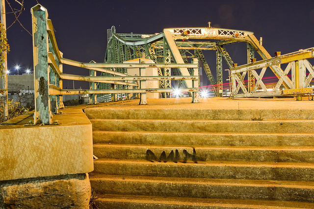
– photo by Mitch Waxman
One is paying a bit more attention to the Grand Street Bridge these days than formerly, as the NYC Department of Transporation has announced their intention to replace it with a more modern structure purpose built to handle current traffic needs. The current Grand Street Bridge is the 1903 model, and the third iteration of a crossing between Brooklyn and Queens on this spot. The section of Newtown Creek it crosses is considered a tributary, and it’s called “The East Branch.”
Once upon a time, the East Branch flowed into Ridgewood, where it was fed by freshwater streams and springs trickling down the “ridge” which you’ll discern when walking along Onderdonk Avenue and other eastern destinations. Ridgewood is the beginning of actual geologic rock formations, with all the land west of it being elluvial fill deposited by glacial and riverine flooding. That’s why the zones around Newtown Creek are so flat, if you were wondering. The actual terminal morraine of Long Island begins a bit to the north east at Mount Olivette Cemetery, in proper Maspeth.
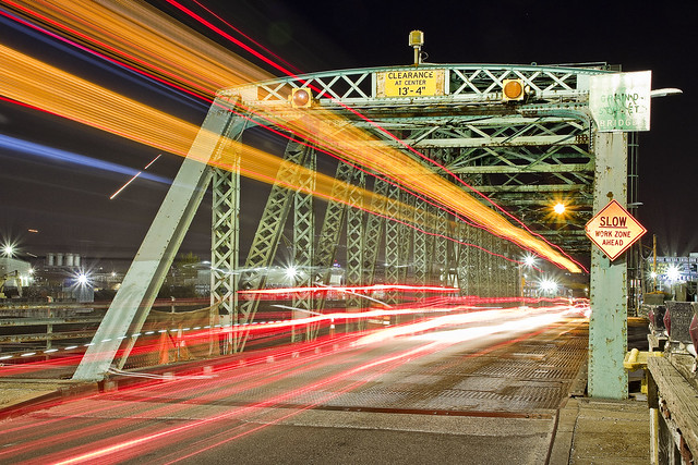
– photo by Mitch Waxman
One has been attempting to get as much night shooting around Newtown Creek in as possible before the weather turns bitter cold, which is why you’ve been seeing so much of it lately. I’ve been noticed by a few people wandering around the concrete devastations with a ridiculous yellow safety vest draped over the filthy black raincoat, setting up the tripod and all the other necessary gear needed for the pursuit. With the exception of few encounters with bored but zealous security guards, it’s been a fairly solitary pursuit, although in a couple of locations I opted to bring somebody along with me to watch my back. Frequent commenter and persistent curmudgeon Don Cavaioli was with me at English Kills last week, for instance, but for the shots in yesterday and today’s posts I was on my own.
I’ve been asked about personal security by a few people, but it’s not something I worry too much about. My biggest safety concerns have been centered around not getting squished by a truck, or snapping my ankle on a hidden sinkhole or fallen branch while picking my way around in the dark. If I had to call 911 for help in an emergency, I’d likely have a devil of a time describing where I am to them as I don’t think “Maspeth Plank Road” or “former Phelps Dodge” is necessarily reflected in the municipal system. My plan for such an eventuality would actually involve first calling one of my colleagues at Newtown Creek Alliance, beseeching them to aid in sending rescuers to a humble narrator.
“follow” me on Twitter- @newtownpentacle


Meddle not in the affairs of Pentacle wizards for they are subtle and quick to anger.
So you’re calling me a curmudgeon?
Pot meet kettle.
Don Cavaioli
Cav
November 14, 2018 at 4:59 pm
It would really be nice to keep the Grand Street bridge but unfortunately it has been obsolete since the late 1940’s, doesn’t open and needs to be replaced.
Cav
November 14, 2018 at 5:03 pm
Hello Mitch,
Thanks as always for your ruminations, thoughts, photography, research, etc.
Do you have any recommendations for bars serving tap beer in the LIC area?
PS: Anything specifically superfundy regarding Anable Basin compared to the rest of LIC?
Best Regards,
Dibis
Dibis Blastofs
November 15, 2018 at 11:46 am
Can’t miss with LIC Bar on Vernon, and I’m a big fan of the cocktails at Jackson’s on the creek side of Jackson Avenue (directly over the VJ 7 stop). As far as “future superfund site” Anable Basin, I’m going to be writing about all that in the future.
Mitch Waxman
November 15, 2018 at 12:42 pm
Once again the Byzantine process that governs commenting here has swallowed my supremely enjoyable and quite brilliant diatribe, much to everyone’s great loss (that’s all 3 other readers on this blog!)
Ugh.
Bushwick = west of Graham, bounded by Grand to the North, running eastward til Morgan.
W’msburg = has no official cardinal sub-denomination according to any collective consensus on nomenclature (just typical REI snake-talk). It generally “sits atop” Bushwick. While it’s northwestern sector is bounded by the BQE as popularly imagined (exit 34), neatly separating Greenpoint above from W’msburg below, it’s NE sector is *not*: instead of delineating the boundaries btw the two ‘hoods neatly, the BQE birfucates NE W’msburg fr SE W’msburg as it runs into the bridge. At no point that I am aware of does Greenpoint somehow manage to touch Bushwick WITHOUT going through some part of Williamsburg. And not “east” Williamsburg, just Williamsburg. East Williamsburg was a lie made up to get transplants to part with more money than they had to for the privilege of living south of Western Beef. The irony is that the ones who actually living *in* W’msbrg along Morgan, by Olive Park, and so on somehow convinced themselves they were actually in E-WB or “North Bushwick” and the fiction stuck.
I grew up on the border of BW/WB, right on Grand. With industry all around to the east and south, and residences to the north and west. The massive RE figure who shaped the landscape in many ways got the City to call the whole affair the IBZ – so it doesn’t really matter anyway.
https://www.bisnow.com/new-york/news/land/city-releases-plan-aimed-at-spurring-development-in-industrial-brooklyn-95135
Tommy Efreeti
November 21, 2018 at 11:10 am