Posts Tagged ‘Liberty Bridge’
A heck of a hill
Thursday

– photo by Mitch Waxman
After having descended along the German Square stairs as described in prior posts, a humble narrator found himself in Pittsburgh’s South Side Flats neighborhood. This ‘zone’ is pretty urban in character, and ‘old timey’ in terms of its building stock. I’m of the belief that there’s a ‘historic district’ rule which applies to certain sections of the Flats, but as I’m trying to avoid deep dives into historical records these days…
This shot looks towards the Monongahela River and the South Tenth Street Bridge, and that’s one of Duquesne University’s buildings rising out of the bluff on the other side of the river.

– photo by Mitch Waxman
Closer to the shoreline, and looking back towards the prominence which I had just descended from – that’s one heck of a hill, ain’t it?
My goal for the remainder of this scuttle involved getting close to the water, and grabbing a pint of beer at that brewery alongside the CSX trackage which has been mentioned several times.

– photo by Mitch Waxman
While quaffing my Pilsner, I noticed a towboat navigating the Monongahela and passing under the Liberty Bridge. As you can tell, the sun was in the early stages of setting. Nice light.
I would be taking the T light rail back to HQ, which ain’t really that much of an adventure but hey – I love the novelty of surface based rail transit through an urban space.
Back tomorrow.
“follow” me on Twitter- @newtownpentacle
Buy a book!
“In the Shadows at Newtown Creek,” an 88 page softcover 8.5×11 magazine format photo book by Mitch Waxman, is now on sale at blurb.com for $30.
Disfunction Junction
Monday
– photo by Mitch Waxman
A gorgeous spring-like day saw a humble narrator walking all over Pittsburgh, as detailed in last week’s posts. The end of my longish scuttle occurred, and I settled in at an often visited brewery which is located along the Three Rivers Heritage Trail and the ‘Colors Park,’ where outdoor seating and active railroad tracks used by the CSX outfit are found.
I’m very fond of this spot, as it’s a grade crossing (the tracks intersect with a local street) with signal alarms that alert you when a train is nearing, and thereby you have ample warning to get into position and frame your shot. Also, there’s beer.
Choo Choo.
– photo by Mitch Waxman
One ended up having more than one glass of beer, I’ll confess, and it was dark when I set out for the T Light Rail station to acquire a ride home. I was testing out the ‘fail zone’ of a newish 50mm f1.8 lens on this leg of the day, I should mention.
The 50mm lens is pretty bare bones, electronics wise, and doesn’t offer ‘image stabilization’ technology inside the housing. My camera has an internal sensor based stabilization system, which gives me about three stops of wiggle room, but when I attach a stabilized lens to the thing I get an amazing eight stops worth of mechanical assist. The lack of stabilized glass on the thing caused me to throw away a few train shots, which just weren’t sharp enough to ‘make the grade.’
I made a mental note about sticking with my stabilized f1.8 35mm, or 85mm f2, for handheld night shots like the one above.

– photo by Mitch Waxman
Back home in Dormont some five miles away, and just as I was leaving the T Light Rail station, a Pittsburgh bound T train set was seen leaving the station. Couldn’t resist.
Back tomorrow with something different – at this – your Newtown Pentacle.
“follow” me on Twitter- @newtownpentacle
Buy a book!
“In the Shadows at Newtown Creek,” an 88 page softcover 8.5×11 magazine format photo book by Mitch Waxman, is now on sale at blurb.com for $30.
Scuttling with trains
Friday

– photo by Mitch Waxman
On the south side of the Monongahela River, where a scuttling narrator found himself walking on the Three Rivers Heritage trail, and CSX #2720 was framed up all nice against the Fort Pitt bridge after it hurtled into the frame, here in Pittsburgh. I knew 2702 was coming, as I had heard signal arm alarm bells ringing from about a half mile distant, and one was desirous of making sure that I ‘got the shot.’ I had ceased experimenting with my two new lenses for a moment, and installed an ‘old reliable’ onto the camera – the 35mm f1.8.
This sort of ‘photowalk’ catch as catch can thing is a whole lot easier when you’ve got a zoom lens on the camera, but that wasn’t the point of what I was doing on this particular day. Test the new glass and get some exercise, that was me.

– photo by Mitch Waxman
There wasn’t any cargo being moved around on #2720, instead it was one of several locomotive engines that were coupled together and moving westwards on the tracks. I continued along the trail’s path, with the ultimate goal of arriving at that brewery I’ve been enjoying hanging around at, and rehydrating myself with a pint of Pilsner.
After quaffing my glass of beer, there were a few more lens tests which I wanted to perform in low light, and my plan was to ride the T light rail back towards HQ. I absolutely treasure the days when I don’t have to drive and can leave the Mobile Oppression Platform back home, in the driveway. The pluses of owning a car are many, but there’s also the whole responsibility thing and sometimes I just want to be ‘foot loose and fancy free,’ if you know what I mean.

– photo by Mitch Waxman
Another CSX train – #4228, pictured above – came roaring towards me. Where this shot was gathered, there’s a grade crossing of the tracks and a couple of those signal arms with the bells. That gave me the time and warning required to swap out the 35mm for the 16mm, and test out its focus tracking performance.
Where the shot above fails for me revolves around the wide angle distortion, which distracts me. The big discovery, mentioned earlier in the week, about this particular lens is that your subject needs to be in the dead bang center of the frame or the image distorts oddly. Live and learn, huh? That’s the whole point of testing a gizmo and seeing what it can do and where it fails.
Back next week with more – from the Paris of Appalachia, at this – your Newtown Pentacle.
“follow” me on Twitter- @newtownpentacle
Buy a book!
“In the Shadows at Newtown Creek,” an 88 page softcover 8.5×11 magazine format photo book by Mitch Waxman, is now on sale at blurb.com for $30.
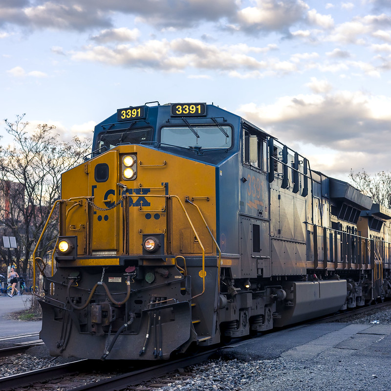
Chillin like a villain
Thursday

– photo by Mitch Waxman
After a medium length walk, one needed to wait out the oncoming sunset, so I visited that bar I’ve been hanging out in that offers somewhat unparalleled railroad views. I ordered a pint, and sat down about 7 pm, with sunset meant to occur just before 8 pm. It didn’t take long.
That’s CSX #3356, a General Electric ET44AC model locomotive.

– photo by Mitch Waxman
In case you’re curious, this is the scene from a more personal perspective and occupation. This bar is called “Sly Fox Brewery,” and it seems to be connected to a real estate project called ‘The Highline.’ Said development sits across the tracks from the HQ of the local bicycle people, and a public park called ‘The Color Park.’ Visiting the latter is how I stumbled upon the former.
Pretty decent cup of beer, I’d mention. That’s a Pilsner. I like a cold yellow beer during warm weather, but switch over to stouts like Guinness when it’s cooler. Despite the abundance of postings from this establishment in recent weeks, I don’t actually drink all that much, rather I’m a ‘nurser’ and that pint glass lasted me around 40 minutes. At any rate, I like sitting outside and I especially like the fact that a nearby series of grade crossings for the rail tracks means that alarm bells go off in advance of the trains.

– photo by Mitch Waxman
Trains are damnably difficult to photograph. First off – they’re huge. Secondly, they are moving much faster than the human eye would suggest they are. Even with the signal alarm bells going off, it’s a panic to get your settings right and compose a shot as the train comes rocketing through.
I’m actually pretty happy with the sun dogs and strobing in the shot above, as a note. I was using a counterintuitive formula for these – f11 at 1/2000th of a second at ISO 6400. That combination gave me a broad hyperfocal range, froze the action, and also produced a nice pixel density in the RAW file for me to work with during the developing stage.

– photo by Mitch Waxman
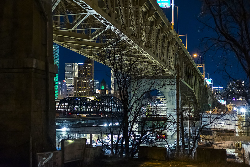
I paid my tab as the sun was going down and proceeded to the so called Highline, which is probably somewhere in the neighborhood of about 60 feet or so over the spot pictured in the second shot. It’s the overpass you see in the third one directly above.
One unfurled the tripod and set the camera up for ‘low and slow’ shooting at ISO 100 and a narrow aperture of f18. The shutter speed for the shot above was 15 seconds, which preserved some of the texture of the waters of the Monongahela River and the clouds. That’s a concrete outfit at the left, and the busy Liberty Bridge is in silhouette.

– photo by Mitch Waxman
As it got darker, the settings changed. The camera’s aperture got wider and the exposure times longer. One of the tricks to low light photography is being conscious of the color temperature of the scene. Digital capture happens on three plates – RGB, or Red, Green Blue. If you’ve got your camera set up with a capture temperature that leans red, it means very little representation on the blue plate and you get a noisy image. Yes, you can change the temperature in Adobe camera RAW, but I’ve learned that the capture temperature really matters.
Pittsburgh still uses old school sodium bulb street lamps, so you need to compensate for the saturated yellows and oranges which that sort of scenario creates and casts. Lately, I set my custom temperature to about 2750 Kelvin, whereas back in NYC with its modern LED street light luminaires I’d use 3800 K.

– photo by Mitch Waxman
While heading back out towards the street, which I’d walk a few blocks of to get to the T light rail station, where I’d in turn acquire a ride back home, I waved the camera around a bit while it was still attached to the tripod.
Why not drive? I’m an absolutist when it comes to drinking and driving, and the whole point of the day was to get some exercise anyway. Not a drop passes the lips when I’m expected to be behind the wheel. Automobiling in Pittsburgh is difficult enough without being impaired. Additionally, it kind of ties my hands in terms of wandering and discovering, since I have to worry about the car.
“follow” me on Twitter- @newtownpentacle
Buy a book!
“In the Shadows at Newtown Creek,” an 88 page softcover 8.5×11 magazine format photo book by Mitch Waxman, is now on sale at blurb.com for $30.
Up, down, all around
Thursday
– photo by Mitch Waxman
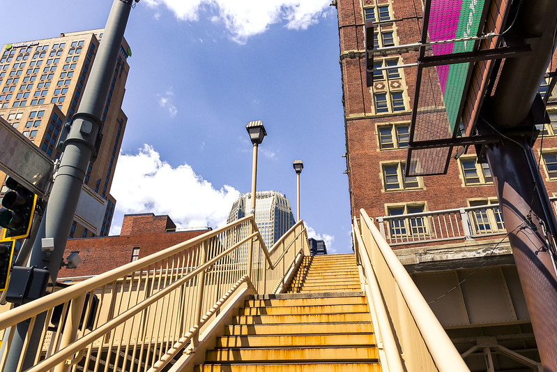
My plan for a ‘long walk’ on this particular day was to force myself into a state of continuous motion for around four hours, so after riding the T from the suburb of Dormont and into the City of Pittsburgh, a humble narrator started kicking his feet around.
My original route was altered by construction on the T which saw it not stopping where I had intended to go, but who cares about that? I soon found myself at a municipal staircase leading up the ‘Boulevard of the Allies,’ which in turn would lead me to a crossing of the Monongahela River over the Liberty Bridge.
– photo by Mitch Waxman
This was only the second time I’ve walked this path, one which I declare as being pretty cool. A recent addition to my kit has been a fishing hat that I bought at Costco for $12. The burning thermonuclear eye of god itself is a baleful entity here in the Pittsburgh area, and on relatively clear summer days it’s a malignant force. I needed something with a bit more cover than a baseball cap, and found my personal desires answered at a warehouse store found, in a shopping mall, that sits on land that used to be occupied by what once was the nation’s largest steel mill. I never felt more American.
It’s funny. My entire life has been defined by the NYC ‘thing’ where you’ve got a knapsack with you when you leave the house in the morning, which contains every thing in it you’re going to need until returning home at night. I’m still adjusting to having a car to stuff gear into, and that it’s ok to bring an extra heavy tripod with me because why not? The NYC experience saw me working feverishly to shave a half pound, or even a few ounces, of weight out of my camera bag, and carefully considering putting one lens or another into my camera bag based on how much the thing weighs rather than what it does.
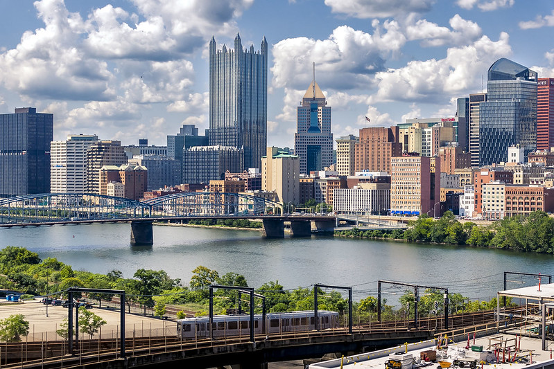
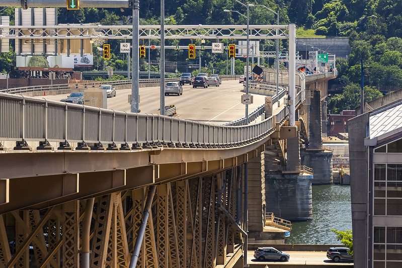
– photo by Mitch Waxman
I’m actually pretty happy with the shot above, captured from the Liberty Bridge. Fairly frustrated was a humble narrator, however, as everywhere that one scuttled to in search of a neat freight rail photo opportunity was utterly empty of such traffic. As is always the case, when I’d walk away from the POV spot, you’d hear a train horn blowing and feel the rumble of it passing. Uggh. Frustrating.
One scuttled about for a while, pushing forward, and eventually – after the four hours of forced marching were over – headed back to the T and home to Dormont about 6 miles south of this spot and on the other side of a mountain. Back tomorrow.
“follow” me on Twitter- @newtownpentacle
Buy a book!
“In the Shadows at Newtown Creek,” an 88 page softcover 8.5×11 magazine format photo book by Mitch Waxman, is now on sale at blurb.com for $30.


