Archive for October 2023
Youghiogheny River Lake
Tuesday

– photo by Mitch Waxman
In 1806, the National Road was conceived and funded by the United States’ first President and Congress with the goal of providing an east west route out of Washington D.C., to enable westward expansion, trade, and travel. Today, it’s called Route 40 and it’s a part of the Interstate Highway system, which incorporates several local roads into its path. After visiting the Great Cross in Pennsylvania’s Jumonville (described yesterday), on a day trip out of Pittsburgh, a humble narrator piloted his Mobile Oppression Platform into the corduroy landscapes of the Laurel Highlands. Along the way, in a mist choked ‘hollow,’ the 1944 vintage Youghiogheny River Lake was encountered. I felt the need to pull off the National Road and get a few shots of the lake. That’s the bridge which Route 40 rides across it, in the shot above.
There was a scheduled destination which I was trying to make, in Western Maryland, but as always – I had left HQ in Pittsburgh early and built time into the schedule for moments of serendipity.

– photo by Mitch Waxman
I didn’t venture too far from my route, and these shots were gathered in the parking lot of a recreational marina along Route 40, which sat on a small prominence overlooking the water. The Youghiogheny River is dammed nearby, by a United States Army Corps of Engineers installation that provides flood control, and is also a hydroelectric generating station which adds 12 megawatts of power to the electrical grid.
The Youghiogheny River is a tributary of the Monongahela River, which starts its southeastern journey away from ‘the Mon’ back in the Pittsburgh satellite city of McKeesport. The river is 132 miles long, and the ‘Yough’s’ drainage hinterlands ultimately flow into a watershed feeding into the somewhat distant Mississippi River. There’s a huge tourism and sport fishing industry here at the lake, which is also used as a drinking water resovoir, and the waterfront here draws about a million visitors a year to an otherwise quite rural area.

– photo by Mitch Waxman
While I was shooting these photos, a few codgers were getting ready to lower their boats into the water, off of pickup towed trailers, and they were getting ready to try their luck at harvesting fish. The lake is stocked annually, I’m told, by the USACE and the Pennsylvania Game people with a variety of game species like trout.
This was my first time roaming about in this part of the country, and along the route I encountered something I’ve never witnessed before – National Parklands which were once battlegrounds. In the case of one of these parks, Fort Necessity, the battles occurred before the birth of the United States itself, during the French and Indian War in 1754. Everywhere you go, there’s something ‘George Washington’ related.

– photo by Mitch Waxman
This was largely a scouting mission for me, part of learning about the greater region which Pittsburgh is at the center of. Pittsburgh is a cultural and financial megalopolis separate and distinct from the massive East Coast’s seaboard megalopolis, with New York at its center, or the Great Lakes megalopolis centered around by the zone between Detroit and Chicago. If you’re unfamiliar with the megalopolis concept, here’s a Wikipedia page that sums it up.
I’m making an effort, at the moment, to explore the edges of my new home. I’m using what the local CBS station’s weather people display on their forecast map as one of my guides to map it out. The weather map I see on the news extends into the middle of Ohio, the north side of West Virginia, Pennsylvania’s city of Erie to the north, and to Western Maryland to southeast. The latter is where I was heading on this particular morning.

– photo by Mitch Waxman
Also found along the route to Western Maryland, but much closer to Pittsburgh, is the Laurel Caverns outfit. I remember seeing photos of the caverns on a View-Master disc when I was a little kid, and I’ve always wanted to experience them for myself. That’ll be one of my winter day trips, though. For you youngsters, an analog version of ‘Tik Tok’ travel videos is what View-Master offered several generations before the digital era happened.
This was actually quite a drive. I had started out at about 5 in the morning, with a thermos of coffee, a full bottle of ice water (and a Genoa Salami sandwich) in the car. For vast stretches of the route, the speed limit along this route is quite high, sometimes it was 70 mph. Other sections go through towns and cities, and the speed limit drops as low as 25 mph, or 15 in school zones. Traffic lights pop up here and there as well. I could have gone a bit out of my way and taken the high speed Pennsylvania Turnpike, but then I would have had to pay a bunch of tolls and missed all the cool stuff I saw without gaining a significant advantage in terms of travel time.
As mentioned – scouting for the future, that’s me.

– photo by Mitch Waxman
As is my habit, I had extensively researched the route in advance and had a number of saved locations plugged into Google Maps. At one point, I passed by signage extolling the fact that the Mason Dixon line had just been crossed and I was officially in the ‘South.’
More tomorrow, at this – your Newtown Pentacle.
“follow” me on Twitter- @newtownpentacle
Buy a book!
“In the Shadows at Newtown Creek,” an 88 page softcover 8.5×11 magazine format photo book by Mitch Waxman, is now on sale at blurb.com for $30.
The Great Cross
Monday

– photo by Mitch Waxman
A humble narrator is starting to explore the larger region surrounding Pittsburgh, and recent day trip saw me behind the wheel of the Mobile Oppression Platform and pulling out of my driveway in the dark at about 5 in the morning. A bit of a long drive awaited, and I was heading in the direction of Uniontown, Pennsylvania. There’s a United Methodists religious organization site, in a section near Uniontown called Jumonville, which offers visitors the chance to visit with their ‘The Great Cross’ monument. Said cruciform is perched atop one of the Appalachian ridge line prominences common to the area. Specifically, the rood is on a hill called Dunbars Knob, that sits atop Chestnut Ridge.
I wanted to be there at Sunrise, and catch the light. The cloud cross in the shot above was serendipitous, if you ask me, and it ain’t photoshopped in, btw. It was really hanging up there in the sky for a few minutes, just as the burning thermonuclear eye of god itself was rising in the vault right behind me. It was a bit of a task to keep my, and the camera’s, shadows out of frame.

– photo by Mitch Waxman
It took a bit of navigating to find the entrance at Jumonville, which is a Christian retreat and summer camp, but I made it there by about 6:30 in the morning. The day was brightening, but the sun was still rising, and behind a different ridge line. You’re greeted by a sign, after parking along the road, which welcomes visitors but lays out a few do’s and dont’s for the property. Unarmed with specifically proscribed firearms or illegal drugs, however, I set out to see the sight.
It’s a bit of walk to get up the path to the actual monument, a long spiraling path set against the ground at a 7-10 degree angle. I’m pretty sure they designed it that way to offer a metaphorical meaning to the walk – it’s difficult to get to the cross, but easy to walk away from it – or something like that. Religious architecture often incorporates tangible example into its design. It was only about a 15 minute walk, but I really felt the effort in the thigh and calf muscles.

– photo by Mitch Waxman
I set the camera up for landscape work, with the tripod and a neutral density filter to ‘slow the light’ a bit. The Great Cross is sixty feet high, was erected in 1950, weighs 55 tons and is supported by a 183 ton concrete foundation which contains the names of the thousands of Sunday School kids who contributed dimes to fund its construction. The Great Cross is a bonafide landmark and attraction which is said to be visible on a clear day for some 75 miles, and built of steel and concrete.
Additionally, Uniontown has been vampire free for 72 years now.
This part of south western Pennsylvania is not one I’ve visited before, and it is staggeringly beautiful. The geology of the place involves a series of steeply ridged highlands, which descend precipitously into deep shadowed valleys which will often have water running through them. These valleys are often referred to as ‘Hollows.’ The weather at the top was cool but clear, but a half hour later when I was driving through the valley, the air was choked with pea soup fog and less than a hundred feet of visibility. In my readings about the area, this sort of geology is sometimes referred to as a ‘corduroy landscape.’

– photo by Mitch Waxman
In the last year, and it’s almost been a year now since I abandoned ‘home sweet hell’ back in NYC, my focus has been on learning about my immediate vicinity – basically a 30 mile circle around the center of Pittsburgh. I’ve now got a catalog of spots, and how to get to them, where I can shoot trains or urban landscapes or ‘city stuff.’ The larger Pittsburgh region, however, is what I’m currently looking at. That includes parts of West Virginia, Maryland, and Ohio. Jumonville is about 50 miles from HQ, but it’s a long drive – time wise – as it’s all local roads between here and there. The reason I left HQ so early, in fact, was to beat the traffic.
The Jumonville compound itself was immaculate, with well cared for grounds and cabins for the faithful to stay at, when attended an event or retreat. The only concern I had here was that a male Deer might come charging at me out of the tree line, as this was the very beginning of rut season and the bucks can be aggressive.

– photo by Mitch Waxman
I’m pretty sure that column of vapor is coming from a power plant, which is found in one of those foggy valleys, or ‘hollows.’
Satisfied with myself, the camera gear started to get packed up, but a few last shots were squeezed out. There was a second leg of my day trip which I’d need to get moving on, and a series of shots I’d miss out on if I didn’t get there within a proscribed interval. For those, I’d be crossing the actual Mason-Dixon Line and entering Confederate territory.

– photo by Mitch Waxman
The presence of the barbed wire fencing around the cross, and its obvious metaphor, is not lost upon me. Saying that, they’ve probably had graffiti issues in the past and you have to keep strangers from messing with your stuff. If anyone from Jumonville is reading this, I had a very nice experience at your place, and thanks for allowing strangers and visitors on to your land – as you do. Lovely.
Back tomorrow with more from the Laurel Highlands, at this – your Newtown Pentacle.
“follow” me on Twitter- @newtownpentacle
Buy a book!
“In the Shadows at Newtown Creek,” an 88 page softcover 8.5×11 magazine format photo book by Mitch Waxman, is now on sale at blurb.com for $30.
More Montour, please, and onions
Friday

– photo by Mitch Waxman
A humble narrator likes to ‘kill two birds with one stone’ as much as possible. Our Lady of the Pentacle announced that we had arrived at a shortfall in terms of the stock of fresh fruits and vegetables in our refrigerator, with said statement coinciding with one of my ‘every other day’ jaunts of exercise schedule. We have been buying this form of comestible from a farm’s retail operation, in Pittsburgh’s South Park suburb, which is about a 30 minute drive from HQ. Coincidentally, one of the sections of the Montour Trail is about a 10 minute drive from said farm stand. Hence…
I didn’t think that there would be much interest in seeing the onions, apples, broccoli, cucumbers and other stuff which I bought later on. On the other hand, the Montour Trail is freaking great. The veg was delicious, btw.

– photo by Mitch Waxman
This is a former rail road right of way, and the Montour Railroad’s primary occupation once revolved around coal. You can read all about the company at this Wikipedia link, the Montour Trail at this Wiki page, and for a series of visits I’ve made to the various sections of the trail click here.
There are several ‘rail to trail’ locations all over Pittsburgh, which make for an ideal form of scuttling. You’re separated from traffic, mostly, and the trails are surrounded largely by woodlands. There’s critters and often flowing water, and every so often a Porta Potty is encountered if you were in the mood to have a tinkle. The surface of the trail is generally asphalt or crushed limestone at railroad grade (1 foot of elevation for every hundred feet horizontally), and you could theoretically follow this path from Pittsburgh all the way to Washington D.C. on a bike, or on foot. There’s also several designated camping sites located along the Montour, with the path proceeding through the gorgeous Laurel Highlands and into the Western Maryland Panhandle. Appalachia, amirite?

– photo by Mitch Waxman
Saying all that, I ain’t taking a 152 mile long walk just to end up in D.C., and I’m trying to visit somewhat more local sections of the trail, bit by bit. On this particular day, one was taking a short walk of less than 4 miles. 2 miles in, 2 miles out and back to the dedicated parking lot where I left the Mobile Oppression Platform. Cardio, yo.
Why do I call my car the ‘Mobile Oppression Platform’? Well, back in Queens, where I was the chair of Community Board 1’s transportation committee, one had to regularly endure the performative outrage and politcial ire of the bicycle people. If somebody got hit by a car, it was emblematic or whatever snake oil they were selling this week or that. One particular eidelon of the street safety crowd describes automobiles as – alternatively – ‘two ton death machines,’ or ‘mobile oppression platforms.’ She didn’t realize that Dr. Zoidberg from the TV cartoon Futurama had got there first. When Toyota insisted I give the car a name, Mobile Oppression Platform is what I chose. You can use M.O.P for shortness’ sake.

– photo by Mitch Waxman
All in all, a very pleasant experience was enjoyed by a humble narrator, although the path in this section wasn’t exactly rich in features you’d want to point a camera at. I was quite interested in this masonry bridge, however, due to its stoutness. The point of this walk was walking, exercising the internally lubricated parts of my legs, and first elevating and then sustaining my heart rate for an interval.
The constancy of my walking around thing is something I’m commanded to do by the team of physicians who help me maintain a median level of health. Running would work too, but I only run when something is chasing me. Also, running offers up a spate of other possible injuries you could incur during the act or over time. Overall regular practice of long distance walking is a fairly low impact form of exercise which offers a number of other benefits. I always bring the camera along to keep it interesting, and to push me into going new places.
Give me a choice, I’d be sitting at home in a La-Z-Boy chair, which was the very first thing I bought after moving here last year. That’s some chair, I tell’s ya…

– photo by Mitch Waxman
After about two miles I encountered an obstacle, pictured above, and that served up as good a moment as any to reverse course and head back to the M.O.P.
There is a moving waterbody found alongside this section of the Montour Trail, which is called Montour Run. It’s the water which that stout masonry bridge spans. I’m pretty sure it’s engineered, likely something the rail people created as a drainage system for their berm riding trackway. Don’t know, I’m putting 2+2 together and presuming.

– photo by Mitch Waxman
Thankfully, I found an open sewer or two along the way, which poured their filth and degradation into it. Ahhh… What am I without sewage to talk about, after all? It was a fine concoction, whose miasma told me it was residential and maybe a couple of days old. I learned many things on Newtown Creek, including how to effectively smell from a fellow called ‘Ned the Nose.’
I made it back to the M.O.P. in fine fettle after walking a bit of the Montour Trail, and then drove over to the farm’s market building to fetch the requested vegetables and fruit. A few weeks ago, I bought peaches at that joint which were the size of frigging softballs, but that’s another story. This time around, the hero of the effort were these freakishly large tomatoes. I also bought a basketball sized Cabbage.
Back next week with something a bit different, at this – your Newtown Pentacle.
“follow” me on Twitter- @newtownpentacle
Buy a book!
“In the Shadows at Newtown Creek,” an 88 page softcover 8.5×11 magazine format photo book by Mitch Waxman, is now on sale at blurb.com for $30.
Seldom Seen, indeed
Thursday

– photo by Mitch Waxman
Another recent scuttle was undertaken at the ‘Seldom Seen Greenway,’ a trail nearby HQ in the neighboring community of Beechview here in Pittsburgh. This is about a 15 minute drive from home, and one regularly brings Moe the Dog here for his exercises. Moe stayed at home on this particular day, “protecting” Our Lady of the Pentacle.
Me? I was hoping to catch a train. That arched structure supports freight rail tracks up above, ones which are frequented by the Wheeling & Lake Erie line RR. The tracks are a bit of a climb from street level, I would mention.

– photo by Mitch Waxman
Thanks to Moe pulling me all the place, in his excitements, I had already found a trail leading up to the level of the tracks. Scuttle, scuttle, scuttle. It was a warm day, but quite temperate and comfortable. ‘Sweat shirt and shorts’ weather, if you will.
The W&LE peeps only seem to roll through this area a few times a day, so I was rolling the dice as to whether or not I’d get any shots up there. It’s always worth doing a bit of scouting, though.

– photo by Mitch Waxman
The shot above looks more or less eastwards. There used to be other active tracks up here, by observation, but in modernity you’ve got a single set of steel rails. It’s fairly common to see CSX or Norfolk Southern moving multiple trains a day on their private tracks through Pittsburgh, however there are a few smaller outfits which pass through the area but not as frequently. There’s one outfit on the south shore of the Allegheny River, which I’ve been hunting for when I’m in the neighborhood, but they seem to be a ‘white whale.’ I’ll get a shot or two of them eventually.
One hung about for a bit, but nothing was coming my way. I’m led to believe that Seldom Seen Greenway occupies a plot of land that used to be an 19th century unincorporated town or ‘Potters Village.’ Grain of salt there, I’ve only seen one source for that, which is never a good sign as far as veracity goes. Still, interesting idea.

– photo by Mitch Waxman
I was all lined up for the shot, were a train to suddenly smash into view. These tracks overfly the masonry arch pictured in the first shot, and the Saw Mill Run waterway which flows through the area.
One has learned to listen for trains coming. You don’t hear the squealing of the steel wheels on the rails until they’re quite close, but there’s a distinctive vibration and rumbling sound that’s unique to locomotives as they approach.

– photo by Mitch Waxman
Y’all don’t suppose that the Queens Cobbler followed me to Pittsburgh, do you? I’ve been seeing a lot of abandoned single shoes, again.
Frustrated, the time allotted for exercising both myself and the camera began to run short, and a trip back down a wooded trail to the entrance of Seldomly Seen Greenway was undertaken.

– photo by Mitch Waxman
Of course, just as I was walking under the bridge that I had been walking on moments earlier – the Wheeling & Lake Erie train set come roaring through. Next time, I’m heading up there with a sandwich and a thermos of coffee and I’ll just wait it out. Dang.
Back tomorrow.
“follow” me on Twitter- @newtownpentacle
Buy a book!
“In the Shadows at Newtown Creek,” an 88 page softcover 8.5×11 magazine format photo book by Mitch Waxman, is now on sale at blurb.com for $30.
What rats see
Wednesday
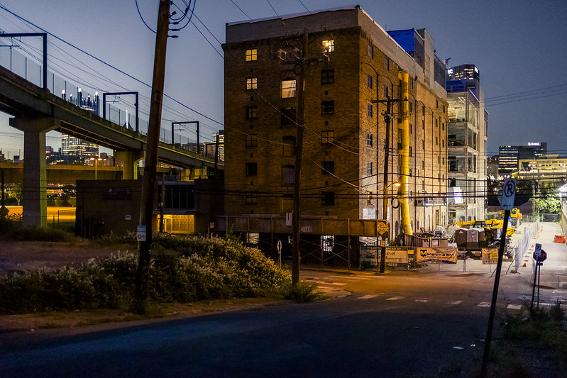
– photo by Mitch Waxman
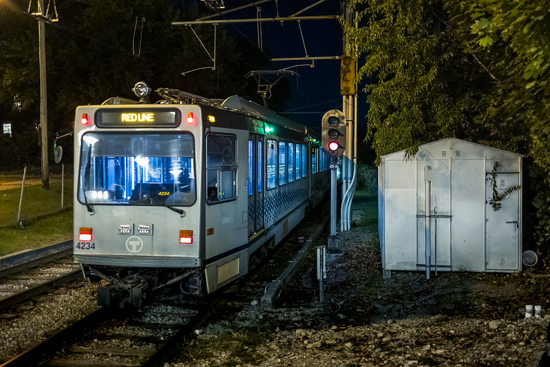
While walking to the nearby T light rail station after leaving the Sly Fox Brewery just after sunset, as described yesterday, one decided to keep on shooting and installed a lens on the camera body which is particularly ‘bright.’
What that means is that the design of the thing allows for an aperture of F1.8, which absolutely drinks in light but creates a fairly narrow depth of field. Whatever I’m focused on will be tack sharp, but everything outside of a fairly narrow zone will fall off into softness. In short, if you’re focused on something far away whatever’s close to you is going to appear fuzzy and soft and vice versa.
– photo by Mitch Waxman
This makes it fairly important to carefully pick what you’re focusing on, of course. A lot of the daytime shots I present here at gathered at a narrow aperture during daylight, usually F8. Alternatively, tripod shots can be as narrow an aperture as F18, which I’ll use when I want everything in frame to be sharply focused and cause those neat little starbursts to form around artificial light.
One has a series of lens based ‘formulas’ for various circumstances. I won’t bore you with all that, however, the technical camera stuff. If you’re interested, ask me when and if I see you in person and I’ll be happy to offer a lesson.
– photo by Mitch Waxman
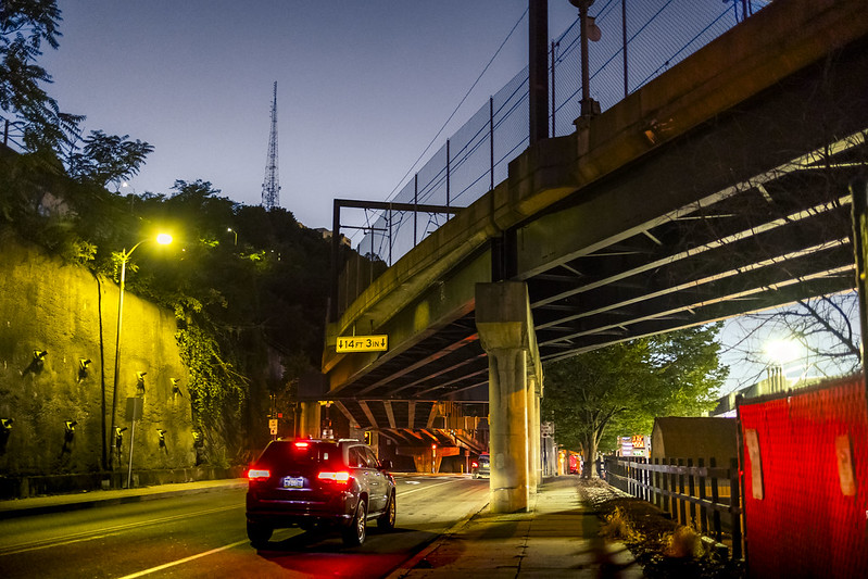
A 20 minute ride on the T light rail found me back in the Pittsburgh Borough of Dormont, where HQ is located. This is about 5 miles away from the spots in Allentown, along Arlington Avenue, the PJ McArdle roadway, and the Sly Fox Brewery where this most recent series of posts were recorded.
Back tomorrow with something different.
“follow” me on Twitter- @newtownpentacle
Buy a book!
“In the Shadows at Newtown Creek,” an 88 page softcover 8.5×11 magazine format photo book by Mitch Waxman, is now on sale at blurb.com for $30.


