Archive for January 2024
Walking the line
Thursday
– photo by Mitch Waxman
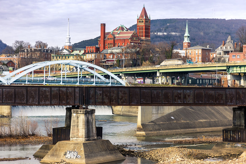
Cumberland, Maryland. I’ve been here before, as detailed in these posts. I was kind of going for a post card look in the shot above. Didn’t have to use filters or anything to make the water look reflective and mirror like, as the entire region had been down in single digit temperatures the night before, and there was lots and lots of ice on the water.
This is the mouth of the C&O towpath canal, which is discussed in one of the prior posts in the link above.

– photo by Mitch Waxman
The emergent problem encountered, for a humble narrator, is that when you drive to place a hundred miles away you’ve also got to drive back home. The four hours of travel time seriously truncates photographic possibility, shortens the tenure of how long you’re willing to spend exploring, and causes you to question why you committed the time and gasoline to the endeavor.
This visit is part of my continuing attempts to visit and familiarize myself with the satellites of the Pittsburgh centered Megalopolis. Oil City and Titusville to the north, Wheeling in West Virginia, Cumberland in Maryland – all have been witnessed.
I’ve got a portfolio of future destinations – Morgantown in West Virginia, Cleveland in Ohio, Erie in Pennsylvania, all over this joint.
Cleveland and Erie, in particular, will require overnight stays due to distance and the length of the drive there. Definitely don’t want to execute a roughly 5 hour drive, and then have to just turn around and head back to HQ.
– photo by Mitch Waxman
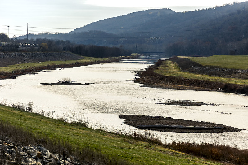
That’s the North Branch of the Potomac River pictured above, with the left side of the shot in Maryland, while the right side is West Virginia.
Also, I should mention that as I’m old, I absolutely loathe driving at night – when adolescents prowl the interstates in Pickups, with no regard for law or custom. Additionally, you’ve got the ‘deer situation’ and ‘no street light dealie’ to handle out here. Brr.
As far as the aforementioned ‘deer situation,’ it is amazing how many ruminant corpses you’ll notice while driving along hereabouts, laying in shattered form alongside the roads.
Back tomorrow with more adventure for a strange man, in this strange land.
“follow” me on Twitter- @newtownpentacle
Buy a book!
“In the Shadows at Newtown Creek,” an 88 page softcover 8.5×11 magazine format photo book by Mitch Waxman, is now on sale at blurb.com for $30.
Salisbury Viaduct
Wednesday

– photo by Mitch Waxman
A humble narrator crossed the Mason Dixon line again recently, and just shy of the famous borderline between America’s ‘North and South,’ a visit was paid to the Salisbury Viaduct in Pennsylvania’s Somerset County, nearby the Commonwealth’s border with Maryland.
Part of the Great Allegheny Passage trail in modernity, this structure was built by the Western Maryland Railroad and opened to rail traffic in 1912. Abandoned in 1975 by the rail people, it was rehabbed into a bike and pedestrian ‘rail to trail’ which opened for inspection in 1998.

– photo by Mitch Waxman
I had a photographer buddy along with me on this particular day. We had delayed our original plans for this road trip to Maryland by a day, because of a precipitous drop in atmospheric temperature and a concurrent series of storms that manifested as the cold front moved in.
When we piled into the Mobile Oppression Platform (The MOP, aka my, my, my Toyota) back in Pittsburgh the next morning, it was 11 degrees outside.
It had warmed up a bit by the time we arrived at Salisbury Viaduct, about 22 degrees according the MOP’s dashboard display. I was wearing two fleece sweatshirts up top, but had neglected to put on thermal underwear leggings for the roadway interface section of the physical plant.
Told you that I’m an idiot in the mornings, and I should have laid them out the night before as a prophylaxis against my stupidity but there we are. My legs were quite chilly, thereby, but once we started walking…

– photo by Mitch Waxman
It’s pretty rural in this zone, which – I’m told – is the Casselman River Valley. Dairy farms, agricultural fields, highways. That’s the service road of US 219 pictured above, with the main road riding on top of those ramps at top left. It’s right here, if you’re curious or want to take a look around on Google Maps or something. Before you say it, I’ve been to the middle of nowhere – which is in Northern Arizona – and this ain’t it.
We were on our way to other locales, but one such as myself is always drawn to these sorts of places. It’s a liminal space! It’s also 101 feet off the ground, so ‘view.’

– photo by Mitch Waxman
Luckily, a CSX freight train was heading… north?… while I was still within throwing distance of the tracks. Recently, another friend (who is coincidentally the Brother of the guy I was hanging out with on this day), told me that I’ve become a railfan.
My answer to that one was that I no longer have tugboats. What do you all say? Have I transcended to a higher level of nerdom? Too much with the train stuff?
To be honest, I enjoy the challenge of shooting something that’s the size of multiple blocks of houses and moving along at 35mph through less than ideal lighting conditions. T’aint all that easy.

– photo by Mitch Waxman
We proceeded to walk the 1,908 foot span of the Salisbury Viaduct. My friend got busy with his camera in an old grave yard on the other side, whereas I became transfixed by a small dairy farm and what Our Lady of the Pentacle might call ‘Moo Cows.’
We had other places to get to on this day trip and a quick half mile walk back to the MOP, in the crisp winter air, was enacted.

– photo by Mitch Waxman
This spot is 115 miles from Pittsburgh, and 218 miles from Washington D.C. It kisses up against the Western Panhandle of Maryland, at its border with West Virginia. It was also very, very chilly.
Tomorrow, the Mason Dixon is crossed, and Western Maryland visited.
“follow” me on Twitter- @newtownpentacle
Buy a book!
“In the Shadows at Newtown Creek,” an 88 page softcover 8.5×11 magazine format photo book by Mitch Waxman, is now on sale at blurb.com for $30.
Flats to Hills
Tuesday

– photo by Mitch Waxman
Today’s post is a short one, offering a few shots gathered while walking from the Birmingham Bridge to a T streetcar station found on the south side of the Monongahela River, here in Pittsburgh.
There’s a bunch of really interesting, and disturbingly heterogeneous, housing stock found in the South Side Flats area. Looks to be late 19th, early 20th to me, and are mainly ‘workers cottages.’ This neighborhood used the Philadelphia style of planning for its layout – short blocks with narrow streets and sidewalks and populated by humble row houses.
I was intrigued by the fire escape on this particular home, for some reason.

– photo by Mitch Waxman
Along my path, several sets of those ‘City Steps’ were bypassed. An accommodation for Pittsburgh’s crazy terrain, these things are everywhere you look. I plan on doing some exploring of this infrastructure in the coming year.
A humble narrator made it to the station just as a ‘T’ Red Line streetcar was arriving, and I quickly boarded it for the five or so mile ride back to home. A random thought invaded, and I rode past my stop to the neighboring community of Mount Lebanon.

– photo by Mitch Waxman
There’s a bar nearby this stop which unfailingly offers Guinness beer on tap. Ubiquitous in NYC, Guinness was always my choice of poison, and I miss being able to count on its presence in the saloons of Queens and Brooklyn. It was time for a pint, and a quick text to home summoned Our Lady of the Pentacle from her domestic comfort to join.
As the poet O’Shea Jackson would say – I gotta say it was a good day.
“follow” me on Twitter- @newtownpentacle
Buy a book!
“In the Shadows at Newtown Creek,” an 88 page softcover 8.5×11 magazine format photo book by Mitch Waxman, is now on sale at blurb.com for $30.
Sky walking, Birmingham Bridge
Monday

– photo by Mitch Waxman
In the last post before my holiday break – during which Newtown Pentacle offered single image posts for the week twixt Christmas and the new year (Happy New Year, btw) – one was describing an interesting walk through Pittsburgh’s ‘Uptown’ neighborhood, and I was threatening to bring y’all along on a walk over the Birmingham Bridge spanning the Monongahela River here in Pittsburgh. I don’t make threats, instead they’re promises, so here we are.
To start: Birmingham Bridge is a positive infant compared to other Pittsburgh Bridges, having opened for business in 1977. Its function is to connect Uptown and the nearby Hill District (on the ‘Golden Triangle’ peninsula) with the South Side neighborhood (found on the south shore of the Monongahela River).

– photo by Mitch Waxman
There’s an enormous concrete outfit found on the peninsular side’s shoreline, which the Birmingham Bridge’s roughly seven stories of altitude offers a nice view of. There’s 64.8 feet of clearance below the span, and the bridge’s length is some 1,662 feet end to end.
It’s a ‘steel bowstring arch bridge,’ and Birmingham replaced an earlier structure which was called the Brady Street Bridge. Birmingham has six vehicular lanes, and there’s the combined pedestrian/bike lane on which a humble narrator claimed temporary residence during this walk.
To my understanding, there were still Steel Mills and Coke Ovens on both sides of the river when this bridge was erected – operated by the Jones & Laughlin company, but both large footprint industrial sites having since been razed and redeveloped since then.

– photo by Mitch Waxman
The distance of this ‘long walk’ a humble narrator was slogging through is best described using landmarks. The T streetcar station I began my scuttling at is located beneath the 64 story U.S. Steel building, which is the tall gray structure at the top right of the shot above.
Stout, the building has become a handy navigational icon for me, which is used in the same manner that I used to employ the Empire State Building, back home in NYC.
As a note: this post is being written on Christmas Eve, and for the first time in a year – I’m actually feeling a bit homesick. I just listened to the Pogues’ “Fairytale of New York” and an actual emotion bubbled up into my sterility of thought and one of the eyes became a bit moist.

– photo by Mitch Waxman
The Birmingham Bridge connects to the South Side neighborhood, on the Monongahela River’s southern shore, specifically to a ‘main street’ called East Carson Street. The former footprint of the J&L steel mill in this area has been redeveloped into an incongruous mixed use development that’s called the ‘South Side Works.’ This very modern development sits alongside centuried residential buildings, which makes the somewhat ‘shopping mall’ esthetic of the South Side Works somewhat visually shocking and out of place. There are also residences in the South Side Works area that are nestled in amongst the shops, all of which seem spacious and modern, but an urban shopping mall is definitely not where I’d want to dwell.
After all those years in Astoria, what Our Lady of the Pentacle and I desire is suburbs. Trees, deer on my lawn. Quiet at night and dark, and if you hear an emergency vehicle’s siren, that’s a remarkable moment.

– photo by Mitch Waxman
Saying all that, a mental picture of ‘what used to be, long ago’ is beginning to form for me here. Weird thing about Pittsburgh as compared to NYC, is that despite having hosted both British and French imperial armies at one time, and having a significant number of ‘young George Washington’ stories associated with it – most of the really interesting things about Pittsburgh start up around the time of the Civil War. NYC, Boston, and… Philadelphia… had already been crowded shitholes for better than 200 years by that point.
I was always more interested in the 1800-1960’s portion of NYC history than the colonial or modern eras, so this probably isn’t terribly surprising.
Speaking of – I gotta figure out where the spot that Lewis and Clark set out from on the Ohio River is. I’d like to see that propitious point of geography, or at least stand upon it. Touchstones, right?

– photo by Mitch Waxman
Melancholy for old times, absent friends, and familiar places notwithstanding, this post was meant to simply discuss a walk over Pittsburgh’s Birmingham Bridge. It’s funny, but allowing my thoughts to drift and cast about is one of the things I enjoy so much about these long walks. Pondering while wandering?
Back tomorrow with the end of this particular adventure, which will conclude the tales of adventure and discovery during this first year in Pittsburgh. Happy New Year, lords and ladies.
“follow” me on Twitter- @newtownpentacle
Buy a book!
“In the Shadows at Newtown Creek,” an 88 page softcover 8.5×11 magazine format photo book by Mitch Waxman, is now on sale at blurb.com for $30.


