Archive for the ‘English Kills’ Category
with palpitant heart

– photo by Mitch Waxman
Startlingly interesting is the only way to describe the experiences of the preceding year. Attempts have been made to cogently describe and colorfully illustrate the encounters your humble narrator has enjoyed in this 10th year of the millennium. For those of you who have just recently started to read this, your Newtown Pentacle, this is your chance to check out some of the highlights of 2010 (according to me), and for the veteran Lords and Ladies of the Pentacle an opportunity to review.
If you’ll indulge me…
January, 2010- The Abbot

The sort of posting which satisfies me deeply, “The Abbot” monument found at Calvary focused my attentions on certain realities of 19th century New York, and proved my theory that Calvary Cemetery is the single greatest historical resource in Queens. Obviation of my satisfaction with the posting is provided by the admission that I had noticed the stone peripherally, found it interesting, and started shooting it with no idea at all about its meaning. Only at home, when reviewing the photos did the whole story come together. Al Smith is buried at Calvary as well (he’s the fellow who built the skyscraper seen in the night shot at the head of this post) but this paragraph is about January 2010 and Governor Smith’s story was told in 2009.
January, 2010- The Great Machine

Also in January, a pet ideation was advanced, one not of theory but of perception. The notion of the megalopolis figures heavily in my thinking- a concept that sees the eastern seaboard of the United States not as a series of cities, but rather one vast urban zone of varying densities with New York City at the titular center of a web of industry, transport, and agricultural systems. The center of the web has a center itself, which is Manhattan- specifically where it connects to “the Great Machine” of the Queensboro bridge and it’s corollaries.

– photo by Mitch Waxman
February 2010– Affordable Housing Development on Borden Avenue

This post, “Affordable Housing Development on Borden Avenue“, is included in the year end wrap up simply because it ended up being one of the more widely read and commented upon endeavors presented in 2010. Most likely, it was the linking shout out from Queenscrap that made it so, rather than any subjective quality or incisive observation. Homeless camps abound in the Newtown Pentacle, hidden away on seldom trodden lanes and along backwater pathways- in this case it’s alongside the oft delayed construction project at the Borden Avenue Bridge which spans Dutch Kills.
February 2010– horrible and unearthly ululations…

A lot of time was spent in 2010 trying to wrap my head fully around the story of the Newtown Creek (which culminated ultimately in the late October release of the first Newtown Pentacle book- Newtown Creek for the vulgarly curious) and “horrible and unearthly ululations…” was the first of several posts which attempted to boil complicated and obscure snippets of historical lore into a cohesive and accessible form. So much is made of the Greenpoint Oil Spill and the Meeker Avenue Plumes by the legal community, whose hungry jowls slaver and shake at the financial possibilities offered by the EPA’s superfund designation and various court decisions, that the true and terrible wonder of the Newtown Creek is often overlooked. This post and several others of its ilk attempt to present a fuller version of things, and act as reminders that what was may once again be.

– photo by Mitch Waxman
March 2010– The Shadow over Sunnyside

The St. Pat’s Day for All parade in Sunnyside is a yearly event which draws in a citywide coterie of political entities, all desperate for attention and attribution as being friendly to the GLTG members of the electorate. The parades origins are a reaction against the banning of outwardly gay marchers in the RC church’s own St. Patricks day parade in Manhattan. Despite its politically contentious birthing, the Sunnyside parade is actually a fun and light hearted event, and signals the coming of springtime in the Newtown Pentacle. While there principally to get shots of the political master race which rules over us, amongst the crowd I noticed small clots of dire intent armed with ugly signage. Research into this group, which was clearly coordinated and queerly ominous, revealed them to be adherents to a bastardized form of Catholic fundamentalism which has been outlawed and defined as a dangerous cult by several Nation-states. A shadow over Sunnyside indeed.
March 2010– Exhausted
A brighter experience for your humble narrator was the Manhattan Bridge Centennial Time Capsule event, on March 5. Interactions and conversations were enjoyed by the least of men with certain powers and potentates of the City of Greater New York and entry to the interior space of the Manhattan Bridge was obtained. One of the high points of my year, “Exhausted” detailed the embedding of a time capsule in the East River Bridge #2- aka the Manhattan Bridge. Remarkable self control was exercised when I met the DOT Commissioner, Jeanette Sadik-Khan. My sincerest desire was to bend her ear with my alleged wisdom about bike lanes and bridge safety- but self control was ascendent that day and only congratulations were offered to both her and the other staffers at DOT.

– photo by Mitch Waxman
April 2010– City of Marble and Beryl
Odd shenanigans were observed at St. Michael’s Cemetery here in Astoria, which were of a decidedly magickal nature. A ritual site that your humble narrator stumbled across was examined and evidentiary examination suggested that certain third world cults were extant here in the old village of Astoria, conducting midnight bacchanals concurrent with the lunar cycle. “City of Marble and Beryl” was but the first of many moons which witnessed a working of will amongst the desolations of our kind.
April 2010– Searching for Gilman

A good part of 2010 was spent “Searching for Gilman” at First Calvary Cemetery, which I am doing as you are reading this, assuming it’s the start of 2011 whenever you do. Gilman is the source of no small amount of pain and financial hardship around these parts, as your humble narrator has become dangerously obsessive and paranoid around the subject. A psychotic need to find Gilman’s grave torments me, coloring my days and painting my dreams a dull yellow.

– photo by Mitch Waxman
May 2010– the king in yellow, brick
Remiss would be apparent were I to not mention the “Madison Avenue Bridge Centennial” but “the king in yellow, brick” advanced another of my pet theories and served up a fascinating (to me at least) sequence of events and relationships which attempts to explain why those yellow Kreischer bricks are all over the older sections of Queens.
May 2010– after cycles incalculable

“After cycles incalculable” is another one of those perfect posts, from a personal perspective. Wandering around with a friend, which is a disturbing trend which developed over the course of 2010, at Skillman Avenue’s start we observed the Lemuria hatching in concordance with the anniversary of the Roman festival of Lemuralia in Long Island City.

– photo by Mitch Waxman
June 2010– from Hells Gate, loosed upon the world

When I set out on my little walks, there is seldom a destination in mind. Literally wandering, obscure symbols and pseudo occultism guide my steps- I’ll follow a black cat, or merely adopt a roughly heliotropic path using my own shadow as compass. At the very end of May, my feet carried me toward Astoria Park and the notorious section of the East River known as Hells Gate. The odd craft, an “unidentified floating object” if you would, which sped past my lens required more than a small bit of detective work to identify- which was detailed in “from Hells Gate, loosed upon the world“.
June 2010– Gods Gift to Pain

English Kills, which is the logical and modern end of Newtown Creek, is a heavily industrialized and largely anaerobic tributary of the larger waterway and is seldom visited (by me, at least) at its extant. One fine day, while hanging out with another Creek enthusiast (you should not go to this place alone), we decided to enter the largely hidden urban foyer which leads here- despite the fact that we were most likely trespassing- which violates Newtown Pentacle policy. The title of the post- “Gods Gift to Pain” was lifted from an enigmatic and appropriate bit of graffiti observed in this forgotten pace of dissolution and poison.

– photo by Mitch Waxman
The reason for Brooklyn, and Queens- why it was a viable alternative to living in Manhattan in the 19th century was defined by the horrors of tenement life. The grand old buildings with their high ceilings, thick plastered walls, convenient dumbwaiters, and incredibly ornate lobbies- the structures which distinguished and made life desirable in the incalculably distant boroughs, were built as an alternative to the crowded and dangerous tenements of “The City”- especially the warren which was known as the “Five Points“. Additionally, Calvary Cemetery (of particular interest to me, and perhaps, to you) was founded by the parishioners of Old St. Patrick’s Cathedral which is smack dab in the middle of this ancient labyrinth of poverty, crime, and squalor. It was decided that to fully understand what one observes in the remains of the supposed “answer to the problem”, exploration of “the problem” itself is required.
July 2010– Bandits Roost, 2010

Ideal source material for the textural and societal milieu of the Five Points is the admittedly biased “How the Other Half Lives” by 19th century do-gooder Jacob Riis. Speaking the truth that power wants to hear is always a sound move if one considers fiscal realities and historical reputation. Attempts were made to find the modern locale in which Riis shot some of his more famous shots, such as this visit to “Bandits Roost 2010“.
July 2010– The house of Dagger John

Another critical visitation for me, as part of my larger education and study of the early development of the City of Greater New York was occasioned on the day when I went to “The house of Dagger John“. Old St. Patrick’s Cathedral satisfies both my continuing fascination with the counterpoint of sacred and profane in the story of the Megalopolis, and figures largely in the predictions of certain obscure lore which governs the schedule of my researches.

– photo by Mitch Waxman
August 2010– not to harsh anyone’s buzz… but…

August of 2010 brought a posting which garnered a lot of attention, due to curbed.com noticing and linking to it. Simply noticing that a growing proliferation of small boats were berthing illegally at the Vernon Avenue street end, it would be irresponsible of me- given everything that I know about the location not to point out the mortal and existential danger that the operators of these boats were placing themselves in. It’s not even the water, really, its the high pressure natural gas line- the enormous CSO which drains LIC- the omnipresent heavy industrial maritime traffic- which makes the spot so hazardous. Mortal threats were received via email (which I’ve kept private), and the comments thread displayed an angry and accusatory tone. As is the case with all such critique, these comments were presented verbatim- here’s a taste: “i have red your article in which you show a great deal of unger towards me and my friends . i believe that you base your article on many misconceptions that are rooted in a lack of communication”, “Blogger or not, the prudent journalist would make an effort to uncover basic facts before publishing a story full of assumptions”, “are you just the type of little man that tells teacher when the cool kids make you feel inferior. The water is public domain! And according to maritime law it is not illegal to moor a boat as long as it safe and looked after.”, “They are not bothering anyone. And get sick from the canal, come on. They are not living down there as far as I know. Parking your boat in the canal is not going to get them sick! Stop over doing it.” Check out “not to harsh anyone’s buzz… but…“.
August 2010– lively antics

One of the greatest joys of living in Queens are the chance encounters you’ll have with people who hail from the furthest points of the compass, such as this Bouzouki player during another visit to Hells Gate. His “lively antics” added splendor to a brightly lit walk around Astoria.

– photo by Mitch Waxman
September 2010– Lucky Shot

Although veteran photographers caution me against use of this term, I call the photo above my “shot of the year”. The steel structure attached to the bottom of the Brooklyn Bridge was installed as part of a bridge painting and maintenance project, and I was luckily along on a Working Harbor trip just as the sun was setting. Right place, right time, it was a “Lucky Shot“.
September 2010– stronger than fear

The dynamic new Safeboats utilized by NYPD and other entities around the harbor were a frequent subject over several of the Working Harbor expeditions I was lucky enough to attend. The many shapes, colorways, and missions of these quick little patrol boats are a delight to observe- and to those who would work maritime malice upon the metropolis- they are the head of the spear. Check out “stronger than fear“.

– photo by Mitch Waxman
A high of the year was the Newtown Creek Cruise which I had the honor of co-narrating with Bernard Ente on October 24th, of course, but the main topic of conversation amongst the antiquarian and environmental communities of the Newtown Pentacle in October revolved around the EPA’s superfund announcement about Newtown Creek at the very end of September. October is spooky time around these parts, and I spent a little time digging around the area for thrills and chills as well.
October 2010– blurred outlines

As part of series of postings detailing what might be seen in the Brooklyn neighborhood of Greenpoint, “blurred outlines” discusses the alleged appearance of a pyrokinetic at 84 Guernsey Street in January of 1895.
October 2010– scenes familiar, and loved

One of my frequent walks through Calvary Cemetery took me to the curiously empty chapel which enjoys the paramount of Laurel Hill. I will admit that I came here this day seeking two things- one was a likely entrance to a vast subterranean structure which underlies the area- the other was a vain hope that the grave of Gilman might present itself in a section which was, at the time, not terribly familiar to me as I normally stay close to the fringes of the place where the whipporwills wail. I very well might have captured what mass media paranormal media sources describe as a ghost orb in “scenes familiar, and loved“.

– photo by Mitch Waxman
November 2010– peace rests nevermore

One of the goals of this, your Newtown Pentacle, is to provide some sort of documentation about this terrible and wonderful place called the Newtown Creek- and I’m happy to say that I was there when the then Attorney General and Governor Elect Andrew Cuomo announced the settlement of a lawsuit brought by his office on behalf of New York State against Exxon-Mobil which involved the Greenpoint Oil Spill. “Peace rests nevermore” indeed.
November 2010– shocking coruscations

Entertaining maritime folklore from past centuries was offered in “shocking coruscations“, which is told against a series of twilight photos from good old Hells Gate between the two great bridges.

– photo by Mitch Waxman
During the cold, when inclement clime restricts my movements and the black dog nips at my heels, I tend toward shorter postings- and in December of 2010 there were two “Then and Now” postings that really took my fancy. These posts are difficult because of the scarce source material available in the public domain, but fun nevertheless. In my usual fashion “dumb idiot” fashion, I had shot the modern views completely unaware of the original photo. Our friends at the Greater Astoria Historic Society have recently released a book of similar historical views, which is worthy of consideration.
December 2010– Bowery Savings Bank 2010 and 1903

As the title states, this is the iconic shell of a once essential and awesomely powerful institution called the Bowery Savings Bank in Manhattan, with a 1903 photo from a similar perspective.
December 2010– Hunters Point Avenue Bridge Centennial

If you told me a year ago that I’d end up doing a press conference with a United States Congresswoman, I’d have hit you. That’s how I ended up at the Degnon Terminal’s own Sunshine Biscuits (LaGuardia Community College) building though, and by an odd coincidence- found myself standing in nearly the same spot as some unknown photographer did in 1921. This posting was built around the announcement of the “Hunters Point Avenue Bridge Centennial” event.

– photo by Mitch Waxman
Overall, a positive and exciting year, despite the deaths of several members of my family.
For a while, I enjoyed a spot on the board of the nascent Newtown Historical Society as a trustee, which is a position that I’ve had to resign for a variety of personal reasons- but I’d like to thank fellow board members Kevin Walsh, Christina Wilkinson, Steve Garza, and Bob Singleton for an interesting and educational experience. Kevin Walsh of forgotten-ny gets a personal call out, as his support, knowledge, and encouragement has been invaluable. Special thanks also are extended toward Capt. John Doswell and Meg Black of the Working Harbor Committee, all the guys and gals aboard the John J. Harvey fireboat, and everybody else who allowed a piss poor specimen such as myself to come along on adventures. Bernard Ente of the Newtown Creek Alliance, Working Harbor, and others also receives a heartfelt gratitude and shout out from this humble mendicant. Standing on the shoulders of giants is difficult if you suffer from altitude related nosebleeds.
What’s next?
Tell you what, feel like taking a walk?
Meet me at the border of Brooklyn and Queens – bring a camera… and ID… I’ll show you something cool…
previous recollections

– photo by Mitch Waxman
Recently, I was obliged to meet up with a couple of guys from Williamsburg when they asked me to guide them through some of the Newtown Creek’s less well known attractions. My pithy reply was that I would be straddling the border of Brooklyn and Queens, and they should just meet me there- at the venerable Grand St. Bridge. I walked there from Astoria in record time, arriving quite a bit earlier than I had anticipated.
Luckily the morning was crisp, my coffee was hot, and the burning thermonuclear eye of god itself was shining strongly- which afforded me with a nice opportunity me to do a little shooting.
Note: I’m never sure how to describe the actual act of photography. Shoot, capture, take- all somewhat violent terms which don’t really fit the action. Sniper techniques do transfer neatly into telephoto work, exhaling while triggering the shutter and all that, but… it’s all rather soldier sounding isn’t it?
from wikipedia
Photography is the process, activity and art of creating still or moving pictures by recording radiation on a radiation-sensitive medium, such as a photographic film, or electronic image sensors. Photography uses foremost radiation in the UV, visible and near-IR spectrum.[1] For common purposes the term light is used instead of radiation. Light reflected or emitted from objects form a real image on a light sensitive area (film or plate) or a FPA pixel array sensor by means of a pin hole or lens in a device known as a camera during a timed exposure. The result on film or plate is a latent image, subsequently developed into a visual image (negative or diapositive). An image on paper base is known as a print. The result on the FPA pixel array sensor is an electrical charge at each pixel which is electronically processed and stored in a computer (raster)-image file for subsequent display or processing. Photography has many uses for business, science, manufacturing (f.i. Photolithography), art, and recreational purposes.
As far as can be ascertained, it was Sir John Herschel in a lecture before the Royal Society of London, on March 14, 1839 who made the word “photography” known to the whole world. But in an article published on February 25 of the same year in a german newspaper called the Vossische Zeitung, Johann von Maedler, a Berlin astronomer, used the word photography already. The word photography is based on the Greek φῶς (photos) “light” and γραφή (graphé) “representation by means of lines” or “drawing”, together meaning “drawing with light”

– photo by Mitch Waxman
Surreal, the waters around the Grand Street Bridge teem with that alien colour which typifies and describes the industrial hinterlands of that annihilation of innocence which is called the Newtown Creek. For an extensive description and history of this spot, a busy automotive and truck crossing in modernity, click the following for the Newtown Pentacle posting “a Grand Journey in DUGSBO”
from nyc.gov
Grand Street is a two-lane local City street in Queens and Kings Counties. Grand Street runs northeast and extends from the Brooklyn Queens Expressway in Brooklyn to Queens Boulevard in Queens. The road is known as Grand Street west of the bridge and Grand Avenue east of the bridge. The bridge is located between Gardner Avenue in Brooklyn and 47th Street in Queens. The Grand Street Bridge is a 69.2m long swing type bridge with a steel truss superstructure. The general appearance of the bridge remains the same as when it was opened in 1903. The bridge provides a channel with a horizontal clearance of 17.7m and a vertical clearance, in the closed position, of 3.0m at MHW and 4.6m at MLW. The bridge structure carries a two-lane two-way vehicular roadway with sidewalks on either side. The roadway width on the bridge is 6.0m and the sidewalks are 1.8m wide. The height restriction is 4.1m. The approach roadways are wider than the bridge roadway. For example, the width of Grand Avenue at the east approach to the bridge (near 47th Street) is 15.11m.
The first bridge on this site, opened in 1875, quickly became dilapidated due to improper maintenance. Its replacement, opened in 1890, was declared by the War Department in 1898 to be “an obstruction to navigation.” Following a thorough study, a plan was adopted in 1899 to improve the bridge and its approaches. The current bridge was opened on February 5, 1903 at a cost of $174,937.

– photo by Mitch Waxman
While pondering the atypical number of 19th century suicides which occurred here, a flock of geese happened along in this so called urban desert and distracted me from my usual morbid soliloquy. They were pecking at the manmade bulkheads, skimming for waterline plant life.
from wikipedia
The Canada Goose was one of the many species described by Linnaeus in his 18th-century work Systema Naturae. It belongs to the Branta genus of geese, which contains species with largely black plumage, distinguishing them from the grey species of the Anser genus. The specific epithet canadensis is a New Latin word meaning “from Canada”. According to the Oxford English Dictionary, the first citation for the ‘Canada Goose’ dates back to 1772. The Cackling Goose was formerly considered to be a set of subspecies of the Canada Goose.

– photo by Mitch Waxman
Nearby was this enormous creature, balancing on one foot . Unfortunately, it wasn’t disposed toward looking my way, despite my best Brooklyn exclamation of “hey, boid, overs here’s”. When a tractor trailer blew by, it suddenly exploded upward.
from wikipedia
New York dialect is predominantly characterized by the following sounds and speech patterns:
Vowels
- The low back chain shift The /ɔ/ vowel sound of words like talk, law, cross, and coffee and the often homophonous /ɔr/ in core and more are tensed and usually raised more than in General American. Labov (1966) describes this pattern as varying on a scale from [ɔ] to [ʊ]. An inglide typically accompanies higher variants giving [oə] or [ʊə]. /ɑ/ in father and /ɑr/ in car are backed, diphthongized, and sometimes rounded to [ɑə] or [ɒə]. The result is that card in New York can be similar to cod in parts of New England. In addition, a subset of words with /ɒ/ as in lot feature a lengthened and diphthongized variant, [ɑə]. This variant may appear before a word final voiced stop, /dʒ/, or /m/ (e.g., cob, cod, cog, lodge, bomb). It also occurs variably before voiced fricatives (e.g., bother), /ʃ/ (e.g., wash), and in the words on, John, and doll (Wells 1982: 514).
- The short-a split There is a class of words, with a historical short-a vowel, including plan, class, and bad, where the historical /æ/ is raised and tensed to an ingliding diphthong of the type [eə] or even [ɪə]. This class is similar to, but larger than, the BATH lexical set, in which Received Pronunciation uses the so-called broad A. Other words, such as plaque, clatter, and bat, retain a lax, low-front [æ], with the result that bad and bat have different vowels. A related (but slightly different) split has occurred in the dialect of Philadelphia. Although the lax and the tense reflexes of /æ/ are separate phonemes in these dialects, their distribution is largely predictable. See Phonemic æ-tensing in the Mid-Atlantic region for more details.
- /oʊ/ as in goat does not undergo fronting; instead, it remains [oʊ]. This groups New York with the “North” class of dialects rather than the “Midland”, in which /oʊ/ is fronted. Relatedly, /uː/ as in goose is not fronted and remains a back vowel [uː] or [ʊu]. This lack of fronting of /oʊ/ and /uː/ also distinguishes New York from nearby Philadelphia. Some speakers have a separate phoneme /ɪu/ in words such as tune, news, duke (historically a separate class). The phonemic status of this vowel is marginal. For example, Labov (1966) reports that New Yorkers may contrast [duː] do with [dɪu] dew though they may also have [dɪu] do. Still, dew is always [dɪu] and never [duː].
- Diphthongs The nucleus of the /aɪ/ diphthong is a back and sometimes rounded vowel [ɑ] or [ɒ] (right as [ɹɑɪt]) and the nucleus of the /aʊ/ diphthong is a front vowel [æ] (rout as [ɹæʊt]). The sociolinguistic evidence (Labov 1966) suggests that both of these developments are active changes. The fronted nucleus in /aʊ/ and the backed nucleus in /aɪ/ are more common among younger speakers, women, and the working and lower middle classes.
- pre-r distinctions New York accents lack most of the mergers before medial /r/ that many other modern American accents possess:
- The vowels in marry [mæri], merry [mɛri], and Mary [meri] ~ [mɛǝri] ~ [mɛri] show either a two- or three-way contrast.
- The vowels in furry /fɜri/ and hurry /hʌri/ are distinct.
- Words like orange, horrible, Florida and forest are pronounced /ɑrəndʒ/ and /fɑrəst/ with the same stressed vowel as pot, not with the same vowel as port as in much of the rest of the United States.
- Merger of /ɜr/ and /ɔɪ/: One of the stereotypes of New York speech is the use of a front-rising diphthong in words with /ɜr/ (e.g., nurse). This stereotype is popularly represented in stock phrases like “toity toid” for thirty-third. The phonetic reality of this variant is near [ɜɪ]. This variant may also appear in words with /ɔɪ/ (e.g., choice), resulting in verse and voice as homophones. The diphthongal variant for /ɜr/ is highly stigmatized. Labov’s data from the mid-1960s indicated the form was recessive then. Only two of his 51 speakers under age 20 used the form as compared with those over age 50 of whom 23 out of 30 used the form. Items with /ɔɪ/ may occur with [ɜr] (e.g., [tɜrlət] toilet), apparently as a result of hypercorrection. Younger New Yorkers (born since about 1950) are likely to use a rhotic [ɜr] in bird even if they use non-rhotic pronunciations of beard, bared, bard, board, boor, and butter.

– photo by Mitch Waxman
Turns out it’s a heron. Go figure, a heron at Newtown Creek.
from wikipedia
The herons are wading birds in the Ardeidae family. There are 64 recognised species in this family. Some are called egrets or bitterns instead of herons. Within the family, all members of the genera Botaurus and Ixobrychus are referred to as bitterns, and—including the Zigzag Heron or Zigzag Bittern—are a monophyletic group within the Ardeidae. However, egrets are not a biologically distinct group from the herons, and tend to be named differently because they are mainly white and/or have decorative plumes. Although egrets have the same build as the larger herons, they tend to be smaller.
The classification of the individual heron/egret species is fraught with difficulty, and there is still no clear consensus about the correct placement of many species into either of the two major genera, Ardea and Egretta. Similarly, the relationship of the genera in the family is not completely resolved. However, one species formerly considered to constitute a separate monotypic family Cochlearidae, the Boat-billed Heron, is now regarded as a member of the Ardeidae.
Although herons resemble birds in some other families, such as the storks, ibises and spoonbills, they differ from these in flying with their necks retracted, not outstretched. They are also one of the bird groups that have powder down.
Some members of this group nest colonially in trees; others, notably the bitterns, use reedbeds.

– photo by Mitch Waxman
That’s it for today, over the weekend I’ll be thrilling you with recent encounters your humble narrator has had with the political class who rule over New York City.
Also, please buy a copy of our book- Newtown Creek, for the vulgarly curious- here. Every copy sold contributes directly to sustaining and maintaining this- your Newtown Pentacle.
from wikipedia
Grand Street is a street in Williamsburg, Brooklyn, New York City, United States. The Grand Street (BMT Canarsie Line) subway station serves the corner of Grand Street and Bushwick Avenue. Crossing English Kills into Queens, Grand Street becomes Grand Avenue, continuing through Maspeth where it is a main shopping street, to Elmhurst. Its northern end is at Queens Boulevard. Broadway continues the thoroughfare north and west.
History
In the 19th century, before the construction of the Williamsburg Bridge, the Grand Street Ferry connected Grand Street, Brooklyn to Grand Street, Manhattan. The Grand Street Line was a streetcar line along the road.
Gods Gift to Pain

Please click through to Flickr and the larger incarnations of the above shot- it’s composed of 7 photos stitched together. Thats 7 fifteen megapixel shots and its HUGE – photo by Mitch Waxman
That extinction of hope called the Newtown Creek enjoys a series of canalized industrial waterways which act as tributaries to its main course. In the past we have visited Dutch Kills, Whale Creek, Maspeth Creek… today, it’s time for a visit to the vicious end of it all.
note: This post violates a number of the rules followed by this, your Newtown Pentacle, regarding rail tracks and probable trespass of private property… yet my hypocrisy knows no bounds. Realize, however, that I was with learned company- individuals overly familiar with this area, its mores, and the rail schedules. Do not come here, especially by yourself- for reasons later explained in this very post!
Welcome to the poison heartlands of New York City, where foul ichors flow freely, and English Kills bubbles in the afternoon sun.
from wikipedia
Newtown Creek is a 3.5 mi (6 km) estuary that forms part of the border between the boroughs of Brooklyn and Queens, in New York City, New York, United States. It derives its name from New Town (Nieuwe Stad), which was the name for the Dutch and British settlement in what is now Elmhurst, Queens. Channelization made it one of the most heavily used bodies of water in the Port of New York and New Jersey and thus one of the most polluted industrial sites in America, containing years of discarded toxins, an estimated 30 million gallons of spilled oil, and raw sewage from New York City’s sewer system. Newtown Creek was proposed as a potential Superfund site in September 2009.

– photo by Mitch Waxman
This is as bad as it gets, one of the few places along the Creek where exposure to the water is life threatening in the short term.
Sure, if you fall off the Grand Avenue Bridge, you’re going to experience broad spectrum antibiotics administered intravenously over the course of a week or two in the hospital- but this stuff is pure dragon blood.
Nauseous miasmas were luckily carried away by stiff breezes, but several times- your humble narrator felt one of his spells coming on.
Up until the latter part of the 20th Century, industries along the creek had free reign over the disposal of unwanted byproducts. With little-to-no government regulation or knowledge of impacts on human health and the environment, it made business sense to pollute the creek. The legacy of this history today is a 17 million gallon underground oil spill caused by Standard Oil’s progeny companies—7 million gallons more than the Exxon Valdez spill in 1989, copper contamination of the Phelps Dodge superfund site, bubbling from the creek bed in the English Kill reach due to increases of hydrogen sulfide and a lack of dissolved oxygen, and creekbeds coated with of old tires, car frames, seats and loose paper. Nearly the entire creek had the sheen and smell of petroleum, with the bed and banks slicked black.
There is no natural freshwater flow into the creek as the historic tributaries were covered over. Flow exclusively consists of contaminated stormwater runoff, carrying trash from numerous bridges, unsewered and wholly paved streets and industrial sites, waste transfer stations, and combined sewer overflows (CSOs) from the city’s sewer system. Moreover, severely toxic groundwater seeps through the bed and banks of the creek. Every year Newtown Creek receives 14,000 million gallons of combined sewage overflow, a mixture of rainwater runoff, raw domestic sewage, and industrial wastewater that overwhelms treatment plants every time it rains. There are also discharges from numerous permitted and unpermitted pollution sources. The creek is mostly stagnant, meaning all the pollutants that have entered the creek over the past two centuries have never left. The creek is also home to a federal Superfund site, several State Superfund sites and numerous brownfields that have not yet secured the attention of regulators.
All is not lost, however. Recently, life is returning to the creek. You can find blue crabs at the mouth, fish swim in its waters, and waterfowl are prevalent. Wetland plants are taking over the abandoned bulkheads and sediment piles and school children are growing oysters, which serve as natural water filters. The Newtown Creek Alliance is actively fighting to help life return to the creek by decreasing pollution and increasing the wetlands along the creek.

– photo by Mitch Waxman
The sickly vegetation, everything, was pulsing with “the colour”. Neither black nor white nor gray, but somehow “shiny”, this alien colour – like something out of space- permeates and identifies the creeklands. Nothing moved, but seemed instead to sway against the wind instead of with it.
In 1655, Director Stuyvesant being absent on an expedition against the Swedes on the Delaware, a horde of armed Indians landed at New Amsterdam, and began to break into houses for plunder. Driven back by the soldiers and armed citizens, they fell upon the unprotected Dutch farmers in the vicinity, many of whom were slain and others taken into captivity. The troubles experienced from the savages were now so alarming as to require the residents of Mespat Kills to concentrate for mutual safety. They, therefore, formed a village on “Smith’s Island,” at the English Kills. The Hon. Nicasius De Sille, who had a patent for the island, had the direction of the new settlement, and called it Aernhem after his native place.

– photo by Mitch Waxman
Dead things were observed in the filth, amongst other unidentifiable shapes and eyeless tubiforms that slithered and flopped and listened from the littoral mud. A vague sense of being watched affected my guides and I, and the loneliness of our location created a sense of certain misgivings which was both real and profound. Nevertheless, I continued my incessant photography, trying to make the best of limited access.
from The Eastern District of Brooklyn By Eugene L. Armbruster, via google books
BEYOND THE NEWTOWN CREEK
In the olden times the lands on both sides of Newtown Creek were most intimately connected. County lines were unknown, the creeks were dividing lines between the several plantations, for the reason that lands near a creek were taken up in preference to others, and the creeks were used in place of roads to transport the produce of the farms to the river, and thus it was made possible to reach the fort on Manhattan Island.
The territory along the Newtown Creek, as far as “Old Calvary Cemetery” and along the East River to a point about where the river is now crossed by the Queensboro bridge and following the line of the bridge past the plaza, was known as Dutch Kills. On the other side of Old Calvary was a settlement of men from New England and, therefore, named English Kills. The Dutch Kills and the English Kills, as well as the rest of the out-plantations along the East River, were settlements politically independent of each other and subject only to the Director-General and Council at Manhattan Island, but became some time later parts of the town of Newtown.

– photo by Mitch Waxman
This place, the very end of English Kills in East Williamsburgh, is non navigable and well beyond the containment boom that is observable from the Metropolitan Avenue Bridge. It hosts a rather large CSO (combined sewer outlet), and is crossed by a rail bridge which connects the massive Waste Management operation to infinite Brooklyn on one side and Queens on the other. The wooden structures which are so pleasingly posed, in their relict decay, are the remains of a former rail bridge which served the same purpose as the modern bridge.
The desk chair above is anybody’s guess.
from habitatmap.org
Combined Sewer Outfall – Newtown Creek 015
- Address Johnson Ave., Brooklyn, NY
- Neighborhood Newtown Creek
- Owner/Occupant NYC DEP
- Location Details Combined Sewer Overflow Outfall NC-015:
- discharges 344.4M gallons per year into English Kills
- Tier 2 outfall
- Ranked 20 out of over 400 in terms of volume
- located at Johnson Ave

– photo by Mitch Waxman
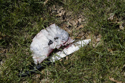
The shores were littered with death and disposal, and I spotted this sad little duck perched out on one of the rail structures. It didn’t seem to be moving very much, and its posture suggested sickness.
The City of New York has plans for this area. Check out page 29 of this PDF
DEP proposes to construct a 9 million gallon CSO storage facility to improve water quality by reducing the CSO discharged into the English Kills during rain storms when the CSO exceeds the capacity of the combined sewers. When this occurs, the CSO would be bypassed to the storage facility. At the end of the rain event the CSO would flow by gravity or be pumped back to the sewer system to be conveyed to the Newtown Creek Water Pollution Control Plant (WPCP) for treatment. This system was recommended by the Newtown Creek Water Quality Facility Planning Project (WQFP), a study that was part of the Citywide Combined Sewer Overflow abatement program.

– photo by Mitch Waxman
Here’s a close up of the duck, which is what I was shooting when my companions and I heard a series of voices and shuffling from the overgrown border of one of the warehouses that abuts the English Kills. Haste was made for a more advantageous position, as we were downhill and the water was at our backs. Strange gutterals were heard emanating from somewhere back in the forbidden brush, a sound almost reminiscent of a dog or bear attempting to speak as a man might- an imitation of speech rather than true use of language.
from epa.gov
Various sediment and surface water samples have been taken along the creek. Pesticides, metals, PCBs, and volatile organic compounds (VOCs), which are potentially harmful contaminants that can easily evaporate into the air, have been detected at the creek.
In the early 1990s, New York State declared that Newtown Creek was not meeting water quality standards under the Clean Water Act. Since then, a number of government sponsored cleanups of the creek have taken place. The New York City Department of Environmental Protection has sampled sediment and surface water at a number of locations along the creek since 1980. In 2009, EPA will further sample the sediment throughout the length of Newtown Creek and its tributaries. The samples will be analyzed for a wide range of industrial contaminants. EPA will use the data collected to define the nature of the environmental problems associated with Newtown Creek as a whole.

– photo by Mitch Waxman
2 men, whose macabre appearance and bizarre style of dress took me aback, emerged from down this trail. Something odd was happening back there, and it was decided that discretion was the best part of valor, and we prepared to exit. Allowing the two men to gain some distance from us (I did not photograph them, out of cowardice) I swung my camera back toward the water and the Waste Management fenceline just as music began to play somewhere back in this wood of suspicion and horror.
from wikipedia
Waste Management, Inc. (NYSE: WM) is a waste management, comprehensive waste, and environmental services company in North America. The company is headquartered in Suite 4000 at the First City Tower in Downtown Houston, Texas, in the United States.
The company’s network includes 367 collection operations, 355 transfer stations, 273 active landfill disposal sites, 16 waste-to-energy plants, 134 recycling plants, 111 beneficial-use landfill gas projects and 6 independent power production plants. Waste Management offers environmental services to nearly 20 million residential, industrial, municipal and commercial customers in the United States, Canada, and Puerto Rico. With 21,000 collection and transfer vehicles, the company has the largest trucking fleet in the waste industry. Together with its competitor Republic Services, Inc, the two handle more than half of all garbage collection in the United States.

– photo by Mitch Waxman
I shot this photo figuring it to be the end of this post, but that’s when I noticed it…
from wikipedia
The eastern half of East Williamsburg, roughly bounded by the Newtown Creek East and by the BQE and Flushing Avenue on the North and South, is mostly zoned for industry with some residential housing mixed among the warehouses and factories. The section is currently referred to by the city as the East Williamsburg Industrial Park (EWIP), or formally the East Williamsburg In-Place Industrial Park (EWIPIP)[8]. The western boundary runs approximately along Kinsgland Ave, then Morgan Avenue and then just East of Bushwick Avenue.
The EWIP is one of eight In-Place Industrial Parks in New York City and is managed by the East Williamsburg Valley Industrial Development Corporation (EWVIDCO), a company founded in 1982 with the goal of revitalizing East Williamsburg by attracting new businesses, providing business assistance to existing firms and grow overall job opportunities in the neighborhood
Historically, this neighboorhood was not part of the Village of Williamsburgh. In the late 1800s the region east of Smith Street (now Humboldt Street), west of the Newtown Creek, south of Meeker Avenue (now the BQE service road)), and north of Metropolitan Avenue was the 18th ward of the City of Brooklyn[10]. The north part of the EWIP is served by the Greenpoint Post Office and is considered by some to be part of Greenpoint. The portion of the EWIP to the South of Metropolitan Avenue was historically part of Bushwick and is still referred by many as being in Bushwick.

– photo by Mitch Waxman
I really have no idea what this is about, and I have read every crackpot theory that has ever been concocted. It very well could just be “ironic” hipster graffiti. I really don’t know, but it’s here at the end of English Kills, where at least two VERY odd characters are camped out. The things I noticed about these two fellows, you see, was this…
Two skinny white guys, late 40’s- early 50’s. Gray hair, both of them. They walked kind of stiff, and they had the colour on them. They lived back there, was my impression. A lot of “down on their luck” people live in these kinds of places- that’s not odd. What was odd- every item of clothing they were wearing still had price tags on them, and their shoes weren’t placed on their feet correctly- one of them had the left foot in the right shoe and so on. It was as if they weren’t used to wearing the clothing of men- or at least the men of this era.
from wikipedia
While it is generally accepted that some homeless people in large cities do indeed make use of accessible, abandoned underground structures for shelter, urban legends persist that make stronger assertions. These include claims that ‘mole people’ have formed small, ordered societies similar to tribes, numbering up to hundreds living underground year-round. It has also been suggested that they have developed their own cultural traits and even have electricity by illegal hook-up. The subject has attracted some attention from sociologists but is a highly controversial subject due to a lack of evidence.
Jennifer Toth’s 1993 book The Mole People: Life In The Tunnels Beneath New York City, [1] written while she was an intern at the Los Angeles Times, is allegedly a true account of travels in the tunnels and interviews with tunnel dwellers. The book helped canonize the image of the mole people as an ordered society living literally under people’s feet, reminiscent of the Morlocks of science fiction writer H.G. Wells.

– photo by Mitch Waxman
As the sign at English Kills says, the one with the little pitchfork in the lower left hand corner:
“In Gods Blessed Darkness Rambo Harnesses Light as Gods Gift to Pain”.
Bigskybrooklyn got some shots of the place during the defoliated winter, which shows a shack back there- check them out.
from nyc.gov
New York City has an estimated 3,306 unsheltered individuals according to HOPE 2008-a ratio of 1 unsheltered homeless individual to 2,485* of the general city population. San Francisco has a 1 in 269 ratio; followed by Seattle with 1 in 295; Miami-Dade County with 1 in 1,741; and Chicago with 1 in 1,798.
There were an estimated 1,263 unsheltered individuals in Manhattan; 279 in the Bronx; 336 in Brooklyn; 135 in Queens; and 152 in Staten Island for a total of 2,165 on the surface (meaning streets and parks). There were 1,141 unsheltered individuals in the subways. Additionally, the Single Adult Shelter Census showed a decline by 19 percent from 8,687 in 2005 to 6,998 in 2008.
opiate peace

– photo by Mitch Waxman
This is not a dead place, this Creek which forms the currently undefended border between much of Brooklyn and Queens, despite wholly inaccurate statements to the contrary recently presented by major publications. To begin with, there is the teeming human infestation, whose population is in the millions. Additionally- migratory birds, invertebrate and vertebrate water fauna, and an enormous hidden population of higher mammals lurk amongst the canalized shorelines of the Newtown Creek.
from the nytimes.com– an article that gets a lot of things completely wrong, which is surprising for the times, and seems to be shilling against “Big Oil”
People don’t often think of urban creeks as biodiverse waterways, but Newtown Creek was once a rich tidal estuary popular among hunters and fishermen. Starting in the 1870s, however, Standard Oil and other refineries began spilling or dumping excess fuels and toxic chemicals into the water or onto the soil, slowly poisoning the ecosystem.

– photo by Mitch Waxman
Famously and recently, a Dolphin’s appearance near the Pulaski Bridge excited the neighboring communities, but such extravagances of nature would have a difficult time at Newtown Creek. There are ocean going and brackish water fish that get swept into the Creek by the East River’s irresistible tidal cycles, which actually drown in the oxygen poor water, but I’ve observed other things swimming in its shallow depths. Weird squamous things that defy description, burrowers and soft bodied tunnelers which thrive in the putrid muds that line its soft bottom. Perhaps, when the federal EPA superfund work begins, studies of these uncommented organisms will commence.
Hey, not everything that lives is beautiful, but against all the odds- life is tenacious and nature will find a way to get by.
from epa.gov
Newtown Creek is a part of the New York – New Jersey Harbor Estuary that forms the northernmost border between the New York City boroughs of Brooklyn and Queens. In the mid 1800s, the area adjacent to the 3.8 mile Newtown Creek was one of the busiest hubs of industrial activity in New York City. More than 50 refineries were located along its banks, including oil refineries, petrochemical plants, fertilizer and glue factories, sawmills, and lumber and coal yards. The creek was crowded with commercial vessels, including large boats bringing in raw materials and fuel and taking out oil, chemicals and metals. In addition to the industrial pollution that resulted from all of this activity, the city began dumping raw sewage directly into the water in 1856. During World War II, the creek was one of the busiest ports in the nation. Currently, factories and facilities still operate along the creek. Various contaminated sites along the creek have contributed to the contamination at Newtown Creek. Today, as a result of its industrial history, including countless spills, Newtown Creek is one of the nation’s most polluted waterways.
Various sediment and surface water samples have been taken along the creek. Pesticides, metals, PCBs, and volatile organic compounds (VOCs), which are potentially harmful contaminants that can easily evaporate into the air, have been detected at the creek.
In the early 1990s, New York State declared that Newtown Creek was not meeting water quality standards under the Clean Water Act. Since then, a number of government sponsored cleanups of the creek have taken place. The New York City Department of Environmental Protection has sampled sediment and surface water at a number of locations along the creek since 1980. In 2009, EPA will further sample the sediment throughout the length of Newtown Creek and its tributaries. The samples will be analyzed for a wide range of industrial contaminants. EPA will use the data collected to define the nature of the environmental problems associated with Newtown Creek as a whole.
DUMABO- Down under the Metropolitan Avenue Bridge Onramp
Click here to see a Google Map of the Metropolitan Avenue Bridge

Metropolitan Avenue Bridge – photo by Mitch Waxman
Once called the Masters’ Bridge, which carried cart and wagon across the 19th century’s Jamaica Turnpike, modernity knows this crossing over the English Kills as the Metropolitan Avenue Bridge.
It lurks on Metropolitan Avenue- between Vandervoort and Varick Avenues in East Williamsburg– Brooklyn. The bridge carries a two-way vehicular roadway with sidewalks, and is a double leaf bascule type bridge erected in 1931, rehabilitated and modernized in 1976, and it received several upgrades in 1992 and 2006.
When the Williamsburgh and Jamaica Turnpike Road was built during 1813-14, Stephen B. and Samuel MASTERS’ operated the Turnpike. under a lease for about twenty years, the toll gate stood near their mill and bridge. MASTERS’ Bridge is replaced by the Metropolitan Avenue Bridge on the old site. When the Brooklyn and Newtown Turnpike Road was built, the toll gate on the Jamaica Road was moved a little further east, to the point where the two roads crossed, Metropolitan and Flushing Avenues at East Williamsburgh in Queens County. The toll gate on the Brooklyn and Newtown Turnpike stood at the same period, about 1857, at Flushing and Knickerbocker Avenues.
Along Newtown Creek, at the junction of Metropolitan Avenue and Grand Street, was a white sandy beach, no building nearby but three boathouses. One of these was occupied by; Captain JACKSON, whose daughter was an expert swimmer, another by old Captain JAKE.
Lafayettes, eels & shedder crabs, were plentiful here and black mussels, used for bait could be picked up in any quantity.
from nyc.gov
Metropolitan Avenue Bridge Over English Kills
Metropolitan Avenue is a two-way local City street in Kings and Queens Counties. The number of lanes varies from two to four along the entire length of Metropolitan Avenue, which runs east-west and extends from River Street in the Southside section of Brooklyn to Jamaica Avenue in Queens. The bridge, the only one over English Kills, carries both Metropolitan Avenue and Grand Street. The bridge is situated between Vandervoort and Varick Avenues in the East Williamsburg section of Brooklyn. The Metropolitan Avenue Bridge is a double leaf bascule bridge with a span of 33.8 m. The general appearance of the bridge has been significantly changed since it was opened in 1931. The bridge provides a channel with a horizontal clearance of 26.2 m and a vertical clearance, in the closed position, of 3.0 m at MHW and 4.6 m at MLW. The bridge structure carries a four-lane two-way vehicular roadway with sidewalks on either side. The roadway width is 16.2 m and the sidewalks are 1.8 m. There are no height restrictions on the bridge.
After the City acquired Metropolitan Avenue from the Williamsburg and Jamaica Turnpike Road Company in 1872, the existing bridge was replaced by a swing bridge, which was also used by the Broadway Ferry and Metropolitan Avenue Railroad Company. Growth in the area made the bridge inadequate by the early 20th century. The current bridge was built in 1931. Modifications since then have included upgrading the mechanical and electrical systems and the replacement of deck, bridge rail, and fenders. The stringers were replaced and new stiffeners added in 1992.

Metropolitan Avenue Bridge Gears – photo by Mitch Waxman
It is, ultimately, the olfactory senses which will allow you to locate this structure amidst the industrial tangle that surrounds the English Kills. The heart of darkness, those waters which stand stagnant here return an oxygenation rate near or at zero, and can measure up to 10 degrees (celsius) higher in temperature than atmospheric conditions would predict. It is close to the bitter ending of the Newtown Creek watershed, the 3.4 mile mark, and only gelatinous horrors extend beyond the bridge- as English Kills winds into the wildest parts of legend haunted and anciently decadent Dutch Brooklyn.
from Brooklyn Eagle, April 30, 1885, courtesy junipercivic.com
Of the 600,000 residents of Brooklyn whose happy lot it is to live south of the little shallow basin that once was known as Bushwick Creek it is not an extravagant estimate to say that quite 85 percent of them have an indifferent idea of the all but putrescent stream, navigable and the center of important industrial interests, which bounds the northern limits of the city – a stream often mentioned in the Eagle under the name of Newtown Creek. There was a time, and that within the recollection of men of middle age, when this creek, the waters of which are today poisoned with the overflow of the waste which comes from the great chemical and other works that line its bank, was the home of fish of diverse forms and flavors. It was the resort of those who delighted in placatorial recreations and rarely were those who cast their lines in its pure waters disappointed of a goodly catch. It had peculiar attractions in this respect. While the creek for nearly three miles inland was a sort of paradise for fish of the ocean kind, above that point the brooks were inhabited by freshwater creatures, a tradition being held by many of the oldest inhabitants that trout of orthodox size and weight once sported in the cool pools that were formed by the outflowings of the springs near Tarquand’s school house. Now, nor for the past two decades, not an inhabitant of the deep is there to be found in it from source to estuary.
from nyc.gov
2-24029-0
|
Borough: |
Brooklyn |
Type: |
Bascule |
|
|
Telephone: |
(718) 388-0008 |
Location: |
Varick/Vandervoort |
|
|
Waterway: |
English Kill |
Miles from Mouth: |
3.4 |
|
|
Channels: |
1 |
Used by: |
Hwy |
|
|
Length: |
440′ |
Max. Span: |
111 |
|
|
Roadways: |
1 – 53′ 0″ |
Sidewalks: |
2 – 5′ 8″ |
|
|
Construction Cost: |
$634,634.86 |
Land Cost: |
Free |
|
|
Total Cost: |
$634,634.86 |
Date Opened: |
Mar. 27, 1933 |
|
Openings:
|
|
1988 |
1989 |
1990 |
1991 |
1992 |
1993 |
1994 |
1995 |
1996 |
1997 |
1998 |
|
Vessel Openings |
756 |
694 |
351 |
301 |
356 |
225 |
310 |
272 |
407 |
423 |
448 |
|
Test Openings |
38 |
82 |
160 |
72 |
154 |
215 |
141 |
131 |
96 |
72 |
140 |

Metropolitan Avenue Bridge Gears – photo by Mitch Waxman
Like the mighty Greenpoint Avenue (or J.J. Byrne Memorial Bridge) drawbridge before it, the titan gears of the bridge reveal themselves to the intrepid photographer when a hidden bascule mechanism is triggered by the manned post and the crossing blossoms open. Redoubtable, the tireless operators of the Newtown Creek bridges are always at the ready to allow a ship egress to the navigable extants of this fabled waterway that are the ruins of an untold and forgotten world. Once, there was more ship traffic in this place than on the Mississippi.
from New York Construction.com
The four-lane Metropolitan Avenue Bridge over the English Kills, an industrial waterway in Brooklyn’s East Williamsburg neighborhood, carries 36,000 cars and trucks daily. Meanwhile, maritime traffic on the waterway below calls for opening the span once a day on average, though during winter months, when ships laden with heating oil are steaming up and down the English Kills, the span opens multiple times each day. The existing 1931 span had replaced another bridge on the site dating to the 19th Century.

Metropolitan Avenue Bridge – photo by Mitch Waxman
People live down along the shoreline here, men with sin pitted faces that wear disgusting expressions indicating unknowable implications. Pitiful, they seem happy, with conveniences such as BBQ’s and collections of flyblown consumer goods cast off by the other spheres of existential reality surrounding them. One can often observe flocks of the higher orders of the avian specie who have mistaken the waters of English Kills for some welcome harbor- a respite from their migratory journeys.
from The History of Long Island, from Its Discovery and Settlement to the Present … By Benjamin Franklin Thompson, via google books
…The eastern portion of the town was known to the natives by the name of Wandowenock, while the western was called Mispat, or Maspeth, the latter being probably the appellation applied to a family or tribe of Indians, residing about the head of the creek, now called English Kills…

Metropolitan Avenue Bridge – photo by Mitch Waxman
Grafitti along the bulkheads of this place absolutely mystifies me. In this occluded and distant ward of the Newtown Pentacle, who will see the scrawled missives rendered at the risk of total immersion in those blackened and still depths with their clawing mud bottoms? The thought of such a baptismal submergence fills your humble narrator with an unspeakable dread at what might emerge from such a font.

Metropolitan Avenue Bridge – photo by Mitch Waxman
What effect does this place have on those outcasts and pariahs who maintain their semi nomadic lifestyle along the waterway (including myself, I suppose)? According to the EPA, several of the chemicals in abundant supply here are not just carcinogenic– but possibly mutagenic.
In 1917, this was the second busiest crossing between Brooklyn and Queens, with 10,944,525 crossings. That’s according to the NYTimes

Metropolitan Avenue Bridge – photo by Mitch Waxman
An air of desolation hangs about the place, looking west. The colour is here in great patches, an irridescent shade of putrefaction which burns wet-hot thoughts into your mind if stared at for too long, and which calls you back to it- time and again. Once, this prime fishing territory and pristine exemplar of the aboriginal Long Island environment supported a vast woodland community, but all that remains is the weedy growth that stabs through winter shattered cement.
A discussion of the topographic and geologic qualities at Newtown Creek, its tributaries, and the logic governing both the height of the various bridges, and the according dredged depth of the soft bottom from google books
From the Annual report of the Secretary of War- by United States. War Dept Volume 2, Part 1- 1893
…A revised estimate for the improvement was made in 1889 (Annual Report Chief of Engineers, 1889, Part I, p. 778), after the results obtained by the survey of January, 1889, bad been studied, and the cost was fixed at 8170,586.
In preparing the new project for the improvement it was kept in mind that the draft of vessels going above Vernon Avenue Bridge, where the most important wharves are located, was limited by the then available depth of water, and that many vessels had to be lightered at the bar to facilitate entrance at high tide, while those going out had to complete their cargoes after they reached the East Kiver. It was, therefore, thought best to provide for 21 feet from the entrance to Vernon Avenue Bridge, 18 feet to Central Oil Works, 15 feet to Queens County Oil Works, 12 feet to Nichols’s Chemical Works, and 10 feet to Metropolitan Avenue Bridge on both branches.
The bed of the creek below Veruon Avenue Bridge is variable in character below the plane of 18 feet, mean low water. Near the bar it is composed of sand or sand and clay mixed; but as the bridge is approached it g.’ows harder, like liardpan, and has large bowlders embedded in it. The creek has a very sluggish current, and where there are no bulkheads the deposits arising from the sewers and from the degradation of the soft and unstable banks cause obstructions to navigation, for which annual dredging is the only possible relief.
The river and harbor act of September 19,1890, appropriated $35,000 for continuing the improvement, and was applied throughout the main river, giving 21 feet at the entrance and 10 feet at the head of navigation. In the ” English Kills,” a northern branch of the river skirting Laurel Hill, a channel was made 700 feet long, 100 feet wide, and 10 feet deep, mean low water. The contract was closed August 24, 1891.

Metropolitan Avenue Bridge – photo by Mitch Waxman
The tributary of the Newtown Creek which the Metropolitan Avenue Bridge crosses is called English Kills. Right next door to the Dutch Kills, and the Dutch town of Boswijk (Bushwick) this name speaks of a forgotten world of internecine European political warfare and New World land grabbing. Here’s how it came by that designation:
from The Eastern District of Brooklyn By Eugene L. Armbruster, via google books
BEYOND THE NEWTOWN CREEK
In the olden times the lands on both sides of Newtown Creek were most intimately connected. County lines were unknown, the creeks were dividing lines between the several plantations, for the reason that lands near a creek were taken up in preference to others, and the creeks were used in place of roads to transport the produce of the farms to the river, and thus it was made possible to reach the fort on Manhattan Island.
The territory along the Newtown Creek, as far as “Old Calvary Cemetery” and along the East River to a point about where the river is now crossed by the Queensboro bridge and following the line of the bridge past the plaza, was known as Dutch Kills. On the other side of Old Calvary was a settlement of men from New England and, therefore, named English Kills. The Dutch Kills and the English Kills, as well as the rest of the out-plantations along the East River, were settlements politically independent of each other and subject only to the Director-General and Council at Manhattan Island, but became some time later parts of the town of Newtown.
Here’s why it’s called English Kills, from bklyn-genealogy-info.com
HISTORY OF QUEENS COUNTY with illustrations, Portraits & Sketches of Prominent Families and Individuals.
New York: W.W. Munsell & Co.; 1882.
Captain Richard Betts, whose public services appear for fifty years on every page of Newtown’s history, came in 1648 to New England, but soon after to Newtown, where he acquired great influence. In the revolution of 1663 he bore a zealous part, and after the conquest of New Netherlands’ by the English was a member from Newtown of the provincial Assembly held at Hempstead in 1665. In 1678 he was commissioned high sheriff of “Yorkshire upon Long Island,” and he retained the position until 1681. He became a bitter opponent to Director Pieter Stuyvesant and the little town of Bushwick, which he had founded. Under leave from the governor the English settlers had planted their town, but were refused the usual patent, and in 1656 Richard Betts administered a severe blow to Stuyvesant by purchasing the land for himself and 55 associates, from the red men, at the rate of one shilling per acre. The total cost amounted to £68 16s. 4d., which, with the sum of £76 9s. paid to the sachems Pomwaukon and Rowerowestco, extinguished the Indian title to Newtown. For a long series of years Betts was a magistrate. During this time he was more than once a member of the high court of assize, then the supreme power in the province. He became an extensive landholder at the English Kills. His residence was here, in what is still known as “the old Betts house.”
It is further said that here within sight of his bedroom he dug his own grave, in his 100th year, and from the former to the latter he was carried in 1713. No headstone marks the grave, but its absence may be accounted for by the fact that his sons had become Quakers and abjured headstones. The old house which we may enter by lifting the wrought iron latch of heavy construction, worn by the hands of many generations; the polished flags around the old deep well, where the soldiers were wont to wash down their rations, are still as the British left them on their last march through Maspeth. This house is but one of several most ancient farm houses still carefully preserved for their antiquity, on the old Newtown road, between Calvary Cemetery and Maurice avenue. These venerable companions have witnessed many changes, and now enjoy a green old age, respected by the community in which they stand.
For more on the Betts family, click here.

Metropolitan Avenue Bridge – photo by Mitch Waxman
Walking up Metropolitan Avenue, whose sidewalks are balustrated against the oncoming traffic, one sees the Bridge house- an uninspiring box clinging precipitously to the marshy shoreline. Heavy traffic is found on Metropolitan Avenue, and odd characters can be observed loping along in a characteristic New York “gangsta lean“. These men are area workers, vagrants, and neverdowells who can be seen lounging in crumbling doorways, around storefront churches or convenience shops, or seen congregating in tight circles down weed choked alleyways- which betray the characteristic aroma of… well, I did say weed choked. I’ve never had a negative encounter down here, but a sense of being out of one’s element does emerge.
from walknyc.org
The Metropolitan Avenue Bridge is in East Williamsburg and carries substantial bicycle commuter traffic, mostly of people living in the neighborhood going to and from work, but also of this writer (from home in Park Slope to work in College Point). This has merging and diverging traffic (Metropolitan Avenue and Grand Street) at either end and rough pavement at the east end. There is ample room for a bicycle lane in both directions. This and repaving the approaches, especially at the east end, is a worthwhile project for T.A.

Metropolitan Avenue Bridge – photo by Mitch Waxman
The water quality here is awful, in my observation. Stagnant and debased, even the aeration project based across the bridge, with its massive techology and modern scientific approaches, can only alleviate the surface of the pollution problems here, at the English Kills.
The City of New York has plans for this area. Check out page 29 of this PDF
DEP proposes to construct a 9 million gallon CSO storage facility to improve water quality by reducing the CSO discharged into the English Kills during rain storms when the CSO exceeds the capacity of the combined sewers. When this occurs, the CSO would be bypassed to the storage facility. At the end of the rain event the CSO would flow by gravity or be pumped back to the sewer system to be conveyed to the Newtown Creek Water Pollution Control Plant (WPCP) for treatment. This system was recommended by the Newtown Creek Water Quality Facility Planning Project (WQFP), a study that was part of the Citywide Combined Sewer Overflow abatement program.

Metropolitan Avenue Bridge – photo by Mitch Waxman
The aeration project is in its second phase. The third and fourth are the most important- and most expensive. The ultimate villain of the Newtown Creek is New York City. The sewer system, a byzantine and somewhat archaic collection of pipes and brick lined tunnels, drains directly into the estuarine water. Since the natural tributaries which once fed fresh water and caused “flow” were cemented over by the burgeoning metropolii surrounding it, the only “flow” received in this river of tears is runoff wastewater and raw sewage.
In 2006, the firm of Edwards and Kelcey won an award for completing their work early, here in Newtown…
Best of 2006 Award of Merit in the Bridge Category – Presented by New York Construction Magazine to Edwards and Kelcey for design services rendered in the rehabilitation of the Metropolitan Avenue Bridge over the English Kills in Brooklyn, NY. The Award recognizes that the $41 million project was completed a year ahead of the anticipated completion date despite the fact that the rehabilitation work was performed on a working bascule bridge carrying 36,000 cars and trucks daily.

Metropolitan Avenue Bridge – photo by Mitch Waxman
Our Lady of the Pentacle, in her infinite sadness, has heard me designate the following as “The Hundred Year Plan”. For more than a century, the logical course of action for “fixing” the Newtown Creek has been articulated in the form of the “Flushing Canal” or alternately “Flushing Tunnel”. By connecting the Newtown Creek to Flushing Bay via terraforming and aquascaping, a “Flow” would be established (and then combined with sediment dredging)- and the tidal actions of East River and Flushing Bay would sweep it clean. The combined waterway – a grand canal- would offer Queens and Brooklyn a vastly altered and exponentially richer central corridor- neighborhoods which are currently isolated, squalid, and typified by neglect and decay.
This is the theory, and the prevailing solution to the issues surrounding the watershed favored by those hierophantic experts consulted for advice and guidance by this Newtown Pentacle.
from hydroqual.com
A slideshow presentation detailing the plan for aeration (manifested in the surrounding photos) of the English Kills, dating from 2003, can be found here.

Metropolitan Avenue Bridge – photo by Mitch Waxman
The City of New York has further plans for this area. Check out page 30 of this PDF
DEP is proposing to construct two Air Blower Buildings for in-stream Aeration Facilities along the East Branch of English Kills and Dutch Kills. The Aeration Facilities were recommended by the Newtown Creek WQFP project to improve water quality in the Upper English Kills by increasing the dissolved oxygen concentration of the bottom waters. The project will include installation of a diffuser along the bottom of the East Branch of English Kills and Dutch Kills. Blowers housed in the buildings along the shoreline will supply air to the diffuser system.

Metropolitan Avenue Bridge – photo by Mitch Waxman
But, as always, things at Newtown Creek stay the same.
Check out this view of English Kills from 1934, courtesy of NY Public Library

Metropolitan Avenue Bridge – photo by Mitch Waxman
Industries will come and go, and great populations will spring up to service them. The work will go, and the communities will wither.

Metropolitan Avenue Bridge – photo by Mitch Waxman
Politicians will arise and attempt to appease those who stay behind. Bread and circuses, but the grand scale and endless possibilities of earlier days will remain just out of reach.

Metropolitan Avenue Bridge – photo by Mitch Waxman
Just beyond the west side of the bridge, the bulkheads lead back to the Newtown Creek proper, a larger waterway and industrial complex of which English Kills is but a tributary.

Metropolitan Avenue Bridge – photo by Mitch Waxman
Here you can see the “Black Mayonnaise”- a toxic combination of raw sewage, petroleum, and coal tar bubbling to the surface from subaqueous sediments- disturbed by the spinning of a ships propellors.

Newtown Creek Bulkheads – photo by Mitch Waxman
Head west, back along the English Kills, and you’ll be back at the Newtown Creek, quite near the former Mussel Island.
from epa.gov
Newtown Creek is a part of the New York – New Jersey Harbor Estuary that forms the northernmost border between the New York City boroughs of Brooklyn and Queens. In the mid 1800s, the area adjacent to the 3.8 mile Newtown Creek was one of the busiest hubs of industrial activity in New York City. More than 50 refineries were located along its banks, including oil refineries, petrochemical plants, fertilizer and glue factories, sawmills, and lumber and coal yards. The creek was crowded with commercial vessels, including large boats bringing in raw materials and fuel and taking out oil, chemicals and metals. In addition to the industrial pollution that resulted from all of this activity, the city began dumping raw sewage directly into the water in 1856. During World War II, the creek was one of the busiest ports in the nation. Currently, factories and facilities still operate along the creek. Various contaminated sites along the creek have contributed to the contamination at Newtown Creek. Today, as a result of its industrial history, including countless spills, Newtown Creek is one of the nation’s most polluted waterways.
Various sediment and surface water samples have been taken along the creek. Pesticides, metals, PCBs, and volatile organic compounds (VOCs), which are potentially harmful contaminants that can easily evaporate into the air, have been detected at the creek.
In the early 1990s, New York State declared that Newtown Creek was not meeting water quality standards under the Clean Water Act. Since then, a number of government sponsored cleanups of the creek have taken place. The New York City Department of Environmental Protection has sampled sediment and surface water at a number of locations along the creek since 1980. In 2009, EPA will further sample the sediment throughout the length of Newtown Creek and its tributaries. The samples will be analyzed for a wide range of industrial contaminants. EPA will use the data collected to define the nature of the environmental problems associated with Newtown Creek as a whole.


