Archive for the ‘Hudson River’ Category
dreamless sleep

– photo by Mitch Waxman
Another of the so called “Black Arts” of the 19th century, sugar refining was one of the great industries which distinguished New York City and its neighboring municipalities.
The sole survivor of this once omnipresent occupation is found in Yonkers. Raw sugar is barged to this facility for processing, which makes it a neat item to highlight for “Maritime Sunday” here at this, your Newtown Pentacle.
from wikipedia
Yonkers is the fourth most populous city in the state of New York (behind New York City, Buffalo and Rochester), and the most populous city in Westchester County, with a population of 195,976 (according to the 2010 Census). Yonkers borders the New York City borough of The Bronx and is 2 miles (3 km) north of Manhattan at the cities’ closest points.
– photo by Mitch Waxman
These shots were captured in the November, while onboard a Riverkeeper vessel which was performing a regular survey of the downstate waterways, and the good folks at that estimable organization were gracious enough to let a humble narrator ride along.
The Sugar Refinery in Yonkers is relict, a late 19th century mill which is still engaged in its trade.
from wikipedia
The raw sugar is stored in large warehouses and then transported into the sugar refinery by means of transport belts. In the traditional refining process, the raw sugar is first mixed with heavy syrup and centrifuged to wash away the outer coating of the raw sugar crystals, which is less pure than the crystal interior. Many sugar refineries today buy high pol sugar and can do without the affination process.

– photo by Mitch Waxman
American Sugar Refining operates this factory, engaging in what seems to be a quite hazardous industrial process.
It seems that sugar dust can be highly explosive, requiring equipment that is “spark proof” to safeguard against detonation.
Who knew?
from wikipedia
American Sugar Refining Company (ASR). The ASR was incorporated in the state of New Jersey on January 10, 1891, with $50 million in capital. By 1907, it owned or controlled 98% of the sugar processing capacity in the United States and was known as the Sugar Trust. The United States Supreme Court declared in United States v. E. C. Knight Company that its purchase of the stock of competitors was not a combination in restraint of trade. By 1901, the company had $90 million in capital. The company became known as Domino Sugar in 1900.

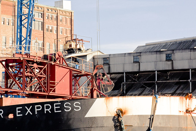
– photo by Mitch Waxman
The tug Heron was present, tending to a barge labeled “Sugar Express”. Heron is middle aged, like myself, and has gone by several different aliases during its long career- unlike myself.
A surprising observation for me was that the raw product was being unloaded from the barge in the same manner that one would unload rock or gravel.
Built in 1968, by McDermott Shipyard of Morgan City, Louisiana (hull #151) as the tug Progreso .
In 1972, the tug was acquired by Dixie Carriers where she was renamed as the Dixie Progress .
In 2002, she was acquired by Allied Transportation of Norfolk, Virginia where she was renamed as the Heron.

– photo by Mitch Waxman
The industrial process of sugar refining uses powerful acids to purify and process the sweet stuff, and in 2005 the plant came under the scrutiny of regulators when it was revealed that they had released a large quantity of powerful acid into the water.
As with everything else in our world, it seems that nature must pay a price for our desires, even when it’s just a teaspoon of sugar to help the medicine go down.
from sawmillrivercoalition.org
In January 2005, American Sugar Refining Inc., a company that produces sugar for Domino Sugar and located on the Saw Mill River, pled guilty to a criminal pollution charge for spilling hydrochloric acid into the Hudson River in Yonkers in 2003.
corporeal presence

– photo by Mitch Waxman
Presented today are a few shots of a very common occurrence presented from a fairly uncommon point of view. The Amtrak train above is traveling down the Hudson toward Manhattan, approaching the Spuyten Duyvil bridge, and the vantage point is onboard a small boat bobbing around in the river.
From Wikipedia
The Spuyten Duyvil Bridge is a swing bridge that carries Amtrak’s Empire Corridor line across the Spuyten Duyvil Creek between Manhattan and the Bronx, in New York City. The bridge is located at the northern tip of Manhattan where the Spuyten Duyvil Creek meets the Hudson River, approximately 1,000 feet (300 m) to the west of the Henry Hudson Bridge. It was built to carry two tracks, but now carries only a single track on the east side of the bridge.
A wooden railroad bridge across the Spuyten Duyvil was first constructed by the New York & Hudson River Railroad in 1849. The current steel bridge was designed by Robert Giles and constructed in 1900; the piers rest on pile foundations in the riverbed. Trains stopped running across the bridge in 1982 and the following year the bridge was damaged by a vessel and left stuck in the open position.

– photo by Mitch Waxman
Amtrak runs a passenger line down the Hudson River which occupies a historic corridor of tracks. As is Newtown Pentacle policy on the subject, your humble narrator freely admits to “don’t know much more than squat” status about the rail system, but the Spuyten Duyvil bridge seems to have suffered a lot of bad luck over the years.
From Wikipedia
Spuyten Duyvil Creek (pronounced /ˈspaɪtən ˈdaɪvəl/) is a channel connecting the Hudson River to the Harlem River Ship Canal, and on to the Harlem River in New York City, separating the island of Manhattan from the Bronx and the rest of the mainland. The neighborhood named Spuyten Duyvil lies to the north of the creek.
Spuyten Duyvil Creek originally flowed north of Manhattan’s Marble Hill. The construction of the Harlem River Ship Canal to the south of the neighborhood in 1895 turned Marble Hill into an island, and in 1914, when the original creekbed was filled in, Marble Hill became physically attached to the Bronx, though it remains part of the borough of Manhattan.
Another realignment of the creek occurred in the 1930s, to the west of the original realignment. This had the opposite effect: It separated a portion of the Bronx and resulted in its attachment to Manhattan as a small peninsula where the Inwood Hill Park Nature Center is now situated.
“Spuyten Duyvil” literally means “Devil’s Spout” or Spuitende Duivel in Dutch; a reference to the strong and wild currents found at that location.

– photo by Mitch Waxman
Several times have I encountered the rumors that these tracks are haunted, in both modern and historical accounts. A long history of tragedy, including a ghoulish 1882 collision, seems to be associated with this place. Fires, maritime and vehicular accidents, pedestrians crossing the tracks being struck, even the weather has nearly done this bridge in more than once. There were sightings of spectral locomotives in the 19th century along this stretch (and all up and down the tracks between here and Albany as well).
There has been much speculation concerning the origin of the name “Spuyten Duyvil.” Dutch in origin, Spuyten Duyvil can be translated in two ways, depending on the pronunciation. One translation is “Devil’s whirlpool,” and indeed, sections of the creek were sometimes turbulent during high tide. The second interpretation is “to spite the Devil.” This translation was popularized by Washington Irving’s story in which a Dutch trumpeter vowed to swim across the turbulent creek during the British attack on New Amsterdam “en spijt den Duyvil (in spite of the Devil).”

– photo by Mitch Waxman
Practical, private, and stern- the iron visage of the laborers who captain these locomotives do not discuss such frivolous subjects with outsiders, and instead focus on craft and profession. It is a sad thing to see the rich folklore of the rails fade away from the American mind, since these were once the miracle machines of “progress”.
You don’t hear kids talking about “John Henry” or “Casey Jones” anymore, for instance, or threaten their parents with jumping onto a passing train and living life as a “Hobo“.
From Wikipedia
The National Railroad Passenger Corporation, doing business as Amtrak (reporting mark AMTK), is a government-owned corporation that was organized on May 1, 1971, to provide intercity passenger train service in the United States. “Amtrak” is a portmanteau of the words “America” and “track”.It is headquartered at Union Station in Washington, D.C.
All of Amtrak’s preferred stock is owned by the U.S. federal government. The members of its board of directors are appointed by the President of the United States and are subject to confirmation by the United States Senate. Common stock was issued in 1971 to railroads that contributed capital and equipment; these shares convey almost no benefits but their current holders declined a 2002 buy-out offer by Amtrak.

– photo by Mitch Waxman
Folkloric to the generations of the latter 19th century, rail offers up some of the greatest stories. Here’s a couple:
Express Train to Hell, Lincoln Death Train.
From Wikipedia
With primarily passenger services, the Northeast Corridor is a cooperative venture between Amtrak and various state agencies. Amtrak owns the track between Washington and New Rochelle, New York, a northern suburb of New York City. The segment from New Rochelle to New Haven is owned by the states of New York and Connecticut; Metro-North Railroad commuter trains operate on this segment. North of New Haven, ownership again reverts to Amtrak, whose tracks stretch to the border between Rhode Island and Massachusetts. The final segment from the border north to Boston is owned by the Commonwealth of Massachusetts.
Under Amtrak’s ownership, the Northeast Corridor suffered from several high-profile electric-power failures in 2006 and other infrastructure problems. Intermittent power outages caused delays of up to five hours for Amtrak and commuter trains. Railroad officials have blamed Amtrak’s funding woes for the deterioration of the track and power supply infrastructure, which in places is almost a hundred years old.
Amtrak owns Pennsylvania Station in New York, 30th Street Station in Philadelphia, Pennsylvania Station in Baltimore, and Union Station in Washington.

– photo by Mitch Waxman
Passenger service is remarkably unexciting, of course, what you want to see are long chains of variegated freight cars hauling lumber and coal and who know what else beneath a stretching trail of steam and smoke painted across the sky. Unfortunately, New York isn’t in that kind of business anymore.
From Wikipedia
The tale of how Spuyten Duyvil got its name is said to be that Peter Stuyvesant, then Governor of New Amsterdam, got wind that the British Navy was going to invade the city. He dispatched Anthony Van Corlaer, to ride up to the northernmost point of Manhattan Island and blow his trumpet, a common means of summoning the people. As he neared the shores where the Hudson meets the Harlem River, Van Corlaer couldn’t cross. It was a stormy evening when he arrived at the upper end of the island, and as no ferryman was available he vowed to swim across the river “in spite of the devil” (Dutch: “in spuyt den duyvil”). Halfway across, legend has it that the devil pulled Van Corlaer under, and while he was able to escape his grasp, he was too tired to continue swimming and drowned there despite his escape. From then on, the little area in the Bronx where Van Corlaer would have come to shore is called Spuyten Duyvil.

– photo by Mitch Waxman
This is the first of several postings detailing certain sites and scenes which were observed along the Hudson, Harlem, and East Rivers on a brisk Saturday in the month of November. The small boat I was on is operated by the good folks at Riverkeeper and a hearty thanks is sent for both their good work and for allowing me to ride along on one of their regular patrols.
From Wikipedia
The P32AC-DM locomotive was developed for both Amtrak and Metro-North so it can operate on power generated either by the on-board diesel prime mover or a third rail electrification system at 750 volts direct current. The P32AC-DM is rated at 3,200 horsepower (2,390 kW), 2,900 horsepower (2,160 kW) when supplying HEP, and is geared for a maximum speed of 110 mph (177 km/h)
The Dual Mode P32AC-DM is unique not only because of its third-rail capability, but also because it is equipped with GE’s GEB15 AC (alternating current) traction motors, rather than DC (direct current) motors as used in the other subtypes. The type is confined to services operating from New York City, where diesel emissions through its two fully enclosed main terminals are prohibited. The P32AC-DM are seen only on Amtrak’s Empire Corridor between Penn Station and Buffalo, the Ethan Allen Express, Lake Shore Limited (New York section), Adirondack, and Maple Leaf services, and locomotive-hauled Metro-North Railroad commuter trains to and from Grand Central Terminal. Metro-North Railroad Genesis locomotives have an escape hatch in the nose.
The Amtrak model third-rail shoes are for use on the over-running third-rail in Pennsylvania Station and the Metro-North Model are for under-running third-rail in Grand Central Terminal.

– photo by Mitch Waxman
A proper historical workup of the bridge, with the patented Newtown Pentacle multi view technology in place, will be forthcoming at some point in the future. You’d be doing your inner geek a disservice by not clicking on the diagram rich PDF linked to below.
an in depth analysis of this bridge (with diagrams, plans, and detailed engineering), and the herculean task of maintaining it, can be found in this 2004 PDF at arema.org
The bridge was originally constructed in 1899 by the King Bridge Company for the New York Central Railroad, and served for many years as a key link for freight delivery by rail to the west side of New Y ork City’ s main borough of Manhattan. Freight rail service to Manhattan dwindled in the years after World War II, but continued through the takeover of the line by Conrail in the 1970s, and into the 1980s. In the 1980s, Conrail discontinued all service on the line. Amtrak acquired rights to the line and initiated a program to start passenger service on the line.
infinitely narrow

– photo by Mitch Waxman
The shot above originated just last week at the Metropolitan Water Aliiance’s gala “Heroes of the Harbor” event. MWA choreographs a “parade of boats” on the Hudson River at sunset, and this year the coup de grace of the parade was the presence of the brand new “343” fireboat. Luckily for me, it maintained a static position on the river while firing its water cannons, and I was able to shoot this neat long exposure image of the FDNY’s new flagship.

– photo by Mitch Waxman
Those stalwart stewards of the public trust at the United States Environmental Protection Agency contacted me the other day and asked that I might disseminate news of two upcoming “Public Information Sessions” which will be conducted in Brooklyn and Queens next week. For more information on specifics, or for more information about the event, check out the official flyer here. I will definitely be attending the Brooklyn event, oddly enough, but scheduled obligation might preclude me from visiting the famed Degnon Terminal (LaGuardia) one.
The dates, locations, and times- as forwarded are:
Tuesday, October 25
St. Nicks Alliance 2 Kingsland Avenue
Arts@Renaissance at the Garden Level, 2:00 to 4:00 pm and 7:00 to 9:00 pm
Thursday, October 27
LaGuardia Community College
31-10 Thomson Avenue, Long Island City
Conference Room E-500, 2:00 to 4:00 pm and 7:00 to 9:00 pm
dream breeding

– photo by Mitch Waxman
The Working Harbor Committee will be presenting the annual Tugboat Race this Sunday, and I hope you’ll be able to make it. The shots in this post are from last year’s race, which I had the privilege of attending.
This is a rare opportunity, from a photographic point of view, to witness this sort of thing. Dynamic, colorful, quick moving- a challenge.
from workingharbor.com
19th Annual Great North River Tugboat Race and Competition Set for Sunday, September 4
Hudson River Park Pier 84 at West 44th Street, Manhattan – 9:30 a.m. – 2 p.m.
Events include a tugboat parade, a mile-long tug race, nose-to-nose pushing contests, line-throwing, spinach-eating and tattoo competitions.
Best viewing is from a Circle Line spectator boat that will follow the on-the-water action.
Good viewing from shore along the West Side riverfront, at Pier 84 and at the Intrepid Museum pier.

– photo by Mitch Waxman
To attend the race, one must simply show up at the pier and enjoy, however the best views (and photos) will be available form the Circle Line observer boat which will labor to keep up with the fleet of contestants. Details on ticketing for the Circle Line boat appear at the bottom of this posting.
Note: As a disclaimer, I’m a member of Working Harbor Committee, but strictly as a volunteer (It’s a non profit organization and I receive zero proceeds for promoting the event).
also from workingharbor.com
Schedule of Events – Sunday, September 4, 2011
- 9:30 a.m. – Spectator Boat departs Pier 83 (boarding begins at 9 a.m.)
- 10 a.m. – Tugboat parade heads north from Pier 84
- 10:30 a.m. – Race begins off Pier i at 70th Street and the Hudson River
- 10:45 a.m. (and earlier) Tugs cross the finish line at Pier 84
- 11 a.m. to noon – Nose-to-nose pushing contests and line-toss competition off Pier 84
- 11:30 a.m. Spectator boat returns to Pier 83
- Noon to 1 p.m. -Tugboats and crews gather for lunch at Pier 84; public is invited to participate in spinach-eating contest and amateur line-toss and knot-tying events
- 1 p.m. – Crew tattoo contest and awards ceremony
- Public Transportation: Any subway to 42nd Street, westbound 42nd Street crosstown bus to the last stop.

– photo by Mitch Waxman
Working Harbor comes up a lot here at Newtown Pentacle, whether it be in the context of the Newtown Creek boat tours or the many “Hidden Harbor” trips which they produce. What doesn’t get mentioned that much are the groups many efforts at promoting and revealing the harbor as a career choice for kids from the inner city, it’s annual Senior Tours (produced in conjunction with the offices of the Borough President of Manhattan) which offer a free day on the water to senior citizens, and a host of smaller events which go largely unsung.
They’re a good bunch of joes.
also from workingharbor.com
New York, New York, August 30, 2011: The Great North River Tugboat Race and Competition-one of New York City’s most popular Labor Day weekend events-returns for the 19th year on Sunday, September 4.
More than a dozen tugboats, the maritime 18-wheelers that normally dock ships and push barges, will thunder down the Hudson River Sunday morning as they vie to be named the fastest boat in their class.
The race, on a one-nautical-mile Hudson River course that extends from about West 70th to West 44th Streets, typically draws thousands of spectators, some watching from shore; others getting right in the middle of the action aboard a Circle Line spectator boat that travels alongside the tugs.
This year, tugs will range from 100-foot, state-of-the art 5,000-horsepower workhorses to a 25-foot, 200 horsepower workboat, named The Bronx, to a century-old harbor tug, now a museum ship, named Pegasus. Working boats from many of New York Harbor’s major towing companies will also complete, including tugs from McAllister Towing and Transportation, Miller’s Launch and Donjon Marine. A handicap system will give smaller and less powerful boats a chance to win trophies.
The race typically draws thousands to the riverfront, which is one of the reasons the tug companies enjoy participating. “New Yorkers sometimes forget they are surrounded by water, and that there is a whole maritime industry working here. This tug competition is the one time a year people can really see what we do,” explained Craig Rising of McAllister Towing and Transportation, one of the largest and oldest tug companies in the country. It is also a field day for the tug crews, many of whom bring their families aboard.

– photo by Mitch Waxman
This is a great party on the Hudson, and a tremendous boost for the crews of the maritime tugs which seldom get a chance to show off their skills and incredible hardware to the public. In addition the race itself, there are “best maritime tattoo” and “spinach eating contests (Popeye brand spinach, natch)“.
Line throwing contests are scheduled, as well as nautical knot tying classes for kids. Family friendly, the event will be at Pier 84 (just south of the intrepid and just north of 42nd street), and the spectator boat will be boarding at the Circle Line pier at 42nd street and the Hudson River.
Hope to see you there.
also from workingharbor.com
The tug race spectator boat will be a Circle Line Sightseeing Boat. It will depart at 9:30 from Circle Line’s Pier 83 at 43rd Street and 12th Avenue (boarding will begin at 9 a.m.), and it will return at 11:30 a.m., so that passengers can walk just one block north to the events on Pier 84. Tickets are $30 adults; $25 for children under 14. Free for ages 4 and under. Tickets can be purchased in advance online at http://www.workingharbor.org or at the Working Harbor Committee tent on the north side of Pier 83 on the day of the event. Admission to the Pier 84 events is free.
The race is organized by the Working Harbor Committee, a not-for-profit organization dedicated to spreading the word about the rich history, current vitality and future potential of the New York/New Jersey Harbor. The organization also provides Hidden Harbor Tours® and runs an extensive youth educational program.
Full information is available at www.workingharbor.org.
Friends of Hudson River Park and Circle Line 42 are co-sponsors.
betwixt the horns

– photo by Mitch Waxman
Call me paranoid, but the Fireboat Three Forty Three seems to be following me around. Everywhere I go these days, there it is. Has anyone ever been stalked by a crewed ship on its shakedown cruise?
Perhaps.
from wikipedia
140-foot, 500-ton, $27 million dollar boat will be the country’s largest fireboat with a maximum speed of 18 knots. The Three Forty Three will provide the FDNY with the latest technology available for Marine vessels, including the capability of pumping 50,000 gallons of water per minute; nearly 30,000 gallons more than its predecessor. The need for this increased pumping capacity was graphically displayed as FDNY’s existing fireboats supplied the only water available for many days after the September 11, 2001 attack on the World Trade Center. However, the technological advances of these new boats do not end there. The boat’s original design by Robert Allan Ltd. of Vancouver, B.C. will catapult FDNY’s Marine Division into the 21st century and beyond.
Because of the very real threat of additional terrorist attacks after 9/11, the boats will also be capable of protecting firefighters from Chemical, Biological, Radiological, Nuclear agents (CBRN). While performing in any of these hostile environments, the crew will be protected in a pressurized area that will also have its air supply filtered by special charcoal and HEPA filters. Assistance on the design of the CBRN system was provided by engineers from the U.S. military’s Joint Program Executive Office for Chemical and Biological Defense and Naval Sea Systems Command. United States Navy.

– photo by Mitch Waxman
Day two of a particularly interesting summer cold, and as you’re reading this (assuming it’s daylight) your humble narrator is most likely aboard a Circle Line and talking on the microphone describing the sights and hidden meanings of NY Harbor to a group of 700 Octa, Nona, and Centenarians.
Such odd moments in life are, of course, owed to the Working Harbor Committee and the Borough President of Manhattan, who makes money available for his constituents in nursing homes to “get out for a day”.
from mbpo.org
Scott M. Stringer, a native New Yorker, is the 26th Manhattan Borough President.
Since taking office at the start of 2006, he has dedicated himself to making Manhattan more affordable, livable…and breathable – preserving the sense of neighborhood for the 1.6 million residents of what is best known as a world capital of culture and commerce.
The foundation for much of the borough president’s work is the change he’s brought to Manhattan’s community boards. Energizing these formal institutions of neighborhood democracy was a top priority of Stringer’s upon becoming borough president. A new merit selection process, combined with an infusion of badly needed resources – such as dedicating to each board a graduate student from the city’s architecture and planning schools – has served to strengthen the voice of Manhattan’s neighborhoods in debates over city planning.

– photo by Mitch Waxman
It was actually a recent Working Harbor trip, this time a program for kids in which representatives of certain maritime organizations like Coast Guard and Port Authority commune with a group of “city kids” onboard a boat, which had brought me to the Hudson on the day these shots were taken. The goal is to introduce to them the idea of a career on the harbor, something not often considered in the wilds of central Brooklyn or Queens.
Another maritime engagement would require me to be at South Street Seaport in the evening, and I had a few hours to kill so I decided to walk from 42nd street to South Street the long way, around the Battery.
from wikipedia
Battery Park is a 25-acre (10 hectare) public park located at the Battery, the southern tip of Manhattan Island in New York City, facing New York Harbor. The Battery is named for artillery batteries that were positioned there in the city’s early years in order to protect the settlement behind them. At the north end of the park is Castle Clinton, the often re-purposed last remnant of the defensive works that inspired the name of the park; Pier A, formerly a fireboat station; and Hope Garden, a memorial to AIDS victims. At the other end is Battery Gardens restaurant, next to the United States Coast Guard Battery Building. Along the waterfront, ferries depart for the Statue of Liberty and Ellis Island, and there is also a New York Water Taxi stop. The park is also the site of the East Coast Memorial which commemorates U.S. servicemen who died in coastal waters of the western Atlantic Ocean during World War II, and several other memorials.
To the northwest of the park lies Battery Park City, a planned community built on landfill in the 1970s and 80s, which includes Robert F. Wagner Park and the Battery Park City Promenade. Together with Hudson River Park, a system of greenspaces, bikeways and promenades now extend up the Hudson shoreline. A bikeway might be built through the park that will connect the Hudson River and East River parts of the Manhattan Waterfront Greenway. Across State Street to the northeast stands the old U.S. Customs House, now used as a branch of the National Museum of the American Indian and the district U.S. Bankruptcy Court. Peter Minuit Plaza abuts the southeast end of the park, directly in front of the South Ferry Terminal of the Staten Island Ferry.

– photo by Mitch Waxman
In planning my route, however, I forgot to factor in the Freedom Tower and the 911 site, which is something I normally avoid like the plague. As a rule, I stay away from this subject, don’t discuss my dead friends who were Port Authority cops or Fire Fighters, and don’t engage in conversational speculation about the event with either the “Truthers” or the conspiracists.
On the other hand, I think that naming a Fireboat “Three Forty Three” is extremely appropriate while the term “Freedom Tower” is just silly and smacks of bad comic book writing.
from wikipedia
One World Trade Center (1 World Trade Center), more simply known as 1 WTC and formerly known as the Freedom Tower, is the lead building of the new World Trade Center complex in Lower Manhattan in New York City. The tower will be located in the northwest corner of the World Trade Center site, and will occupy the location where the original 8-story 6 World Trade Center once stood. The north side of the tower runs between the intersection of Vesey and West streets on the northwest and the intersection of Vesey and Washington streets on the northeast, with the site of the original North Tower/1 WTC offset to the southeast. Construction on below-ground utility relocations, footings, and foundations for the building began on April 27, 2006. On March 30, 2009, the Port Authority confirmed that the building will be known by its legal name of ‘One World Trade Center’, rather than the colloquial name ‘Freedom Tower’. Upon completion, One World Trade Center will be the tallest building in the United States, standing at a height of 1,776 feet (541.3 m), and among the tallest buildings in the world. It will be taller than the Empire State Building, and will be completed by the beginning of 2014.


