Archive for the ‘Long Island City’ Category
Shoosh… Be Very Quiet… I’m hunting rabbits…

– photo by Mitch Waxman
Hunting for the elusive gravesite of a man called Gilman, one frigid afternoon spent within the 365 acres of First Calvary Cemetery proved the existence here of a race of burrowing things- mud caked groundlings with glowing red eyes.
Somewhere, nearby I would suspect, is a subterranean warren kept warm by the swarming masses of their hairless and blind progeny. Squirming, these sweaty holes dug into the frozen graveyard force the adults to brave the bright dangers of the surface world to forage.
from wikipedia:
The lagomorphs are the members of the taxonomic order Lagomorpha, of which there are two families, the Leporidae (hares and rabbits), and the Ochotonidae (pikas). The name of the order is derived from the Greek lagos (λαγος, “hare”) and morphē (μορφή, “form”).
Though these mammals can resemble rodents (order Rodentia), and were classified as a superfamily in that order until the early twentieth century, they have since been considered a separate order. For a time it was common to consider the lagomorphs only distant relatives of the rodents, to whom they merely bore a superficial resemblance.
The earliest fossil lagomorphs, such as Eurymylus, come from eastern Asia, and date to the late Paleocene or early Eocene. The leporids first appear in the late Eocene, and rapidly spread throughout the northern hemisphere; they show a trend towards increasingly long hind limbs as the modern leaping gait developed. The pikas appear somewhat later, in the Oligocene of eastern Asia.

– photo by Mitch Waxman
Prey by nature, the foragers are fast and smart and alert. The gods of the sky, the claws of the stealth demons, the brutal agonies of the dog- all are found on the surface. Designed to eat the ruggose fibers of grass and seed, quickly and as much as possible in one go, they are swift and nervous. Fed on the morbid nutrition offered up by the loam of Calvary Cemetery, the glowing red eyes of these burrowers scan constantly for danger.
from wikipedia:
The rabbit lives in many areas around the world. Rabbits live in groups, and the best known species, the European rabbit lives in underground burrows, or rabbit holes. A group of burrows is called a warren. Meadows, woods, forests, thickets, and grasslands are areas in which rabbits live. They also inhabit deserts and wetlands. More than half the world’s rabbit population resides in North America. They also live in Europe, India, Sumatra, Japan, and parts of Africa. The European rabbit has been introduced to many places around the world.

– photo by Mitch Waxman
Merely a part of some vast ecosystem occluded by the marble and sorrow, these burrowers are prized game for the higher mammals and avian predators which frequent the bulkheaded shorelines of the Newtown Creek. It is difficult, with modern eyes, to imagine the world of the unspoiled Creek.
Once, this was part of a rich swampy marshland, and abundant game and wildlife drew sportsmen from the great cities of Brooklyn and Manhattan for hunting and fishing to the rural extants of the Newtown Creek. Nearby, aboriginal tribes of Lenape (the Maspeatche) made their camps near Mt. Zion cemetery and when the europeans came- great hunting lodges and hotels were erected along its banks to service the tourist trade from the two island cities. That was before the industries, before the Rural Cemeteries Act, and before the 800 pound gorilla came to town.
from wikipedia:
Jugged Hare (known as civet de lièvre in France), is a whole hare, cut into pieces, marinated and cooked with red wine and juniper berries in a tall jug that stands in a pan of water. It traditionally is served with the hare’s blood (or the blood is added right at the very end of the cooking process) and Port wine.
Jugged Hare is described in the influential 18th century cookbook, The Art of Cookery by Hannah Glasse, with a recipe titled, “A Jugged Hare,” that begins, “Cut it into little pieces, lard them here and there….” The recipe goes on to describe cooking the pieces of hare in water in a jug that it set within a bath of boiling water to cook for three hours. Beginning in the nineteenth century, Glasse has been widely credited with having started the recipe with the words “First, catch your hare,” as in this citation. This attribution is apocryphal.

– photo by Mitch Waxman
Your humble narrator appreciates the irony that New York City’s nature preserves are entirely accidental. The nearby Ridgewood Reservoir, an eidelon of municipal malfeasance and neglect, has transformed into a significant bird sanctuary and houses a teeming ecosystem ranging from rodent to raptor. The cemeteries of Queens similarly house a niche ecology, providing a refuge for ghoulish reprobates and rabbit alike. Some effort has been made at finding a scientific sampling of biota at these locations, but if it exists, my meager skills at the art of detection have been unable to uncover such data.
for a third person perspective on how my encounter with this manifest avatar of the Lepus specie went, please click here- its pretty much the way that the whole thing “went down”.
A Great Machine

Queensboro Bridge and associated structures- “The Great Machine” – photo by Mitch Waxman
Queensboro, whose steel has cantilevered the flow of traffic to the shining city from the fabled vastness of the Long Island since 1909, is merely the focal point of a polyglot mechanism whose works spread into the east. The backbone of New York City runs through the marshy hillocks of western Queens.
As I’ve said in the past:
Airports, railroad yards, maritime facilities, petrochemical storage and processing, illegal and legal dumping, sewer plants, waste and recycling facilities, cemeteries. The borders of the Newtown Pentacle’s left ventricle are festooned with heavy industry and the toll taken on the health of both land and population is manifest. A vast national agglutination of technologies and a sprawl of transportation arteries stretching across the continent are all centered on Manhattan- which is powered, fed, and flushed by that which may be found around a shimmering ribbon of abnormality called the Newtown Creek.
Light rail (subway) and vehicle traffic focus toward Queens Plaza, and within a three mile radius of this place can be found- the East River subway tunnels, the Midtown Tunnel, multiple ferry docks, and the titan Sunnyside Rail Yard which connects to the Hells Gate Rail Bridge. This “Great Machine” is the motive engine that allows millions to enter and leave Manhattan on a daily and reliable schedule from North Brooklyn, Queens, Suffolk and Nassau Counties. The great endeavor called “The East Side Access Project” and its associated tunneling is also occurring nearby, which will terminate at a planned LIRR station sited for the corner of Queens Blvd. and Skillman Avenue.
from wikipedia:
The Queensboro Bridge, also known as the 59th Street Bridge, is a cantilever bridge over the East River in New York City that was completed in 1909. It connects the neighborhood of Long Island City in the borough of Queens with Manhattan, passing over Roosevelt Island. It carries New York State Route 25 and once carried NY 24 and NY 25A as well.
The Queensboro Bridge is the westernmost of the four East River spans that carry a route number: NY 25 terminates at the west (Manhattan) side of the bridge. It is commonly called the “59th Street Bridge” because its Manhattan end is located between 59th Street and 60th Streets.
The Queensboro Bridge is flanked directly on its northern side by the freestanding Roosevelt Island Tramway.

Queens Blvd. at Skillman Avenue – photo by Mitch Waxman

Queens Plaza multi level elevated train station – photo by Mitch Waxman
When Queensboro was built, it became the fastest way into town and horse drawn wagons still carried manufactured goods from the mill workshops of Long Island City and agricultural products from points East (hauled into LIC by the LIRR) into Manhattan. The subways tracks were attached to the superstructure of the bridge. Trucks replaced the horse wagons, and eventually made the cargo hauling operation unprofitable for the LIRR’s gantry docks at Hunters Point. The automobile route and light rail options also collapsed the old passenger and cargo ferry industry which sailed from LIC and Astoria (especially Hallets Point). As the population of Queens left its cradle in LIC and along the East River shoreline, moving ever eastward toward the open country of Long Island, the narrow streets of ancient Newtown were given over more and more to industry. The Great Machine reached further toward the dawn, straining to carry the ever increasing load.
note and minutiae: sartorial mention by learned experts has informed me that the myriad colors that the steel in Queens Plaza is painted reflects the particular line or system that it was erected to serve.

Queens plaza complex – photo by Mitch Waxman

Queens Blvd. at 32 pl. – photo by Mitch Waxman
Following the machine past Skillman Avenue, as it carefully skirts the titan Sunnyside Railroad Yards and the cyclopean Degnon Terminal, one finds the auspicious origin of Queens Boulevard. A primary local artery with an elevated subway track directly connected to the Queens Plaza complex, Queens Blvd. is a central viaduct of population movement away from Manhattan toward points east. Sunnyside, Flushing, Roosevelt, Corona exist in their modern incarnation because of this structure- which like many parts of New York City- must be considered from those hidden structures beneath the street in addition to the visible sections.
There are thousands of mechanisms down there, cables and pipes and electrical transformers, steel underpinnings of the road itself. Realize the complexity of designing a street that can carry fully loaded modern trucking without collapse or subsidence, absorb the vibration and crushing weight of active subway tracks, and also carry a subterranean network of sewer and wastewater systems that can handle the storm runoff from so many acres of concrete. Of course, this complexity was designed over generations of dedicated improvements, but it boggles the mind to… think about what it is… that may be… buried down there.
for a thorough history of the neighborhoods which lie along this section of Queens Blvd., complete with historic photography- check out the work of the masters at Forgotten-NY

End of Naked Steel, Queens Blvd. – photo by Mitch Waxman
After diverging from the Queens Plaza complex, the steel is soon observed as clad in artistic cement, and its pleasing appearance mirrors a Roman viaduct. Such architectural analogy, referencing the time before Caesar did away with pretense, was an artifice used extensively in the era of Progress. Look at the majesty of Washington DC, the Tweed courthouse in Manhattan, or Speer’s plans for the New Berlin during the reign of the last antichrist.
from wikipedia:
Queens Boulevard was built in the early 20th century to connect the new Queensboro Bridge to central Queens, thereby offering an easy outlet from Manhattan. It was created by linking and expanding already-existing streets, such as Thomson Avenue and Hoffman Boulevard, stubs of which still exist. It was widened along with the digging of the IND Queens Boulevard Line subway tunnels in the 1920s and 1930s, and in 1941, the city proposed converting it into a freeway, as was done with the Van Wyck Expressway, but with the onset of World War II, the plan was never completed.

Queens Blvd. looking west – photo by Mitch Waxman
This line of rail continues eastward, sending offshoots into extant neighborhoods. Enormous numbers transverse this street, so much so that it generates statistical norms that stand in contrast to surrounding streets only a block or two away. There is a high rate of just about every affliction or situational outcome possible along Queens Blvd., probability is altered by sheer force of numbers. Spikes in auto accidents or criminal activity far out of scale with surrounding neighborhoods has garnered the infamous “Boulevard of Death” nomen and results in scaled up traffic and transit police patrols all along the route. It’s a bit of a misnomer, as the “just passing through” population of any 1 block stretch on Queens Blvd. is easily the size of a small town. Subways, manhattan bound traffic, pedestrians, residents, shoppers, workers- fuhgeddabowdit.
from wikipedia:
This street hosts one of the highest numbers of New York City Subway services in the city. At any one time, six services—the E, F, G, R, V, and the 7—all use significant stretches of the right of way; only Broadway (nine services), Sixth Avenue (seven), and Seventh Avenue (seven) in Manhattan and Fulton Street (eight) and Flatbush Avenue (six) in Brooklyn carry more at any one time. In addition, the Q60 bus travels its entire length.

End of the line out in Corona – photo by Mitch Waxman

39th (Beebe) avenue elevated station – photo by Mitch Waxman
Another branch of the Great Machine slinks out of Queens Plaza along Northern Blvd. and turns at 31st street, carrying the N and soon to be defunct W lines. This structure continues into and provides the only rail link for the extant sections of Astoria found beyond the noble stature of Ditmars Blvd. This stop is the first on the line, serving Dutch Kills, and its nascent hospitality industry. Before long, this stop will be a primary port of embarkation for hordes of tourists returning from Manhattan. What will greet them, currently, is a coffee shop/greasy spoon and a series of auto garages. Most of the private homes along this block have shuttered windows and zero tenancy, undoubtedly being stockpiled for future large scale development.
from wikipedia:
The Astoria Line was originally part of the IRT, as a spur off the IRT Queensboro Line, now part of the IRT Flushing Line (which didn’t open to the north until April 21, 1917). The whole Astoria Line north of Queensboro Plaza opened on February 1, 1917, and was used by trains between 42nd Street–Grand Central and Astoria.

N Train on elevated BMT tracks – photo by Mitch Waxman

– photo by Mitch Waxman
This is one of those hotels, a Holiday Inn which was recently completed on 39th Avenue and 29th street. Eccentric in design, it is one of the larger buildings visible in western Queens, but is already being dwarfed by newer construction nearby. Greatest of all, the thing in the Megalith watches from on high, as Queens rises.
The European travel industry is a highly evolved entity, which sells “package holidays” combining lodging and travel into one flat rate. Profit is found by booking airline seats and hotel rooms in bulk, garnering discounts from suppliers, and reselling at a higher price to consumers. Its all very civilized, and results in a very competitive pricing strategy which offers real value. Imagine, a trip to New York, all-inclusive for a flat rate- and staying at a brand new hotel two stops from the Apple Store and Central Park!
Really, I’m not being sarcastic. If you’re going to Europe, buy a ticket for London and then put your trip together there. You’ll end up flying to Italy or Bruges on some crap airline, where the in flight entertainment is a non stop commercial selling duty free booze and you’re surrounded by the recently drunk, but who cares… you’ll save a bundle as compared to the ala carte system. The hotel will be downright crappy too, but you’re only sleeping there- you’re in Europe- go to a museum or something. That’s pretty much how most international tourists think about Hotels, that’s the market- hopefully the Hotel investments at Dutch kills can grab a piece of it. Really, I’m not being sarcastic, Queens needs those jobs, and this conversion is fairly inevitable.
I wish that nothing would ever change, and I’ll miss the quirky edges and small stature of this enigmatic little neighborhood, but nothing is going to stop this transformation. I just hope that artifacts of what once was, like the LIC millstones, can be preserved and experienced by the public.

– photo by Mitch Waxman
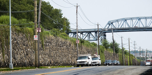
In Sunnyside, another rhiozome of the Great Machine juts eastward, carrying the 800 pound gorilla to eastern Long Island. This shot is just down the hill from the Queens Boulevard photo above labeled “Queens Blvd. looking west”, a mere 3 city blocks away. These tracks continue for miles, connecting with the brobdingnagian Jamaica Yard, and provide connections to the furthest reaches of Long Island. The tracks are elevated above the streets, and incorporate a series of bridges to span the local streets transversed. A tremendous amount of construction work is underway- as observed by your humble narrator during these endless explorations on foot- to shore up and cosmetically improve the narrow strips of land which surround the trackways. The properties had become overgrown, shoddy, and a favorite location for illicit activity and homeless camps.
from wikipedia:
The Main Line is a rail line owned and operated by the Long Island Rail Road in the U.S. state of New York. It begins in Long Island City and runs directly across the middle of Long Island, terminating in Greenport approximately 95 miles (153 km) from its starting point. Along the way, the Main Line spawns five branches. These branches, in order from west to east, are:
- Port Washington Branch (at Wood Interlocking in Woodside, Queens)
- Hempstead Branch (at Queens Interlocking along the Queens/Nassau County border)
- Oyster Bay Branch (at Nassau Interlocking in Mineola)
- Port Jefferson Branch (at Divide Interlocking in Hicksville)
- Central Branch (at Beth Interlocking at Bethpage)

entrance to the Sunnyside Yards – photo by Mitch Waxman
An entrance to the Sunnyside Yards offers a cutaway view of this Queens Plaza Great Machine complex, with the greenish steel structure bisecting the photo called to your attention. That’s Steinway Street where it becomes the 39th street (or Harold Avenue) bridge, and crosses over the Sunnyside Yard toward Queens Blvd. which is 2 blocks away ultimately terminating at 51st avenue by the BQE, just across the highway from old Calvary Cemetery which abuts the Newtown Creek. The great mills of Queens were once served by direct rail links to the Sunnyside Yard, Standard Motor’s stark industrial building with its no nonsense “daylight factory” windows is the luminous structure in the lower right corner, the Amtrak Acela barn is center, and the construction projects visible are at Queens Plaza. In the distance, Manhattan.
for a fascinating discussion of the legal status and deep history of the bridges over the Sunnyside yards, check out this article at dlapiper.com

– photo by Mitch Waxman
A garland of former industrial supremacy, the aforementioned Standard Building is just one of the enormous mills that once provided untold numbers of jobs to western Queens. Shadows, one of these giants now houses a Welfare office, and many have been converted to self storage facilities. On Northern Blvd., which is sited upon the ancient Jackson Avenue Turnpike, the Great Machine is underground. Subway tracks and other subterranean features reveal the entire surface here to be an artifice. Look at the entrance to the Sunnyside Yard shot above for the true grade of the land. This is the roof a structure, part of the Great Machine.
This Great Machine- an interconnecting system of bridges, roadways, and rail (along with power plants, sewers, and workers)- is the sum total of billions of hours of labor. When the remains of our civilization are scratched out of the sand in some future desert, one would hope that the collective work represented in this series of structures will merit some mention- a footnote next to the story of Manhattan.
from wikipedia:
NY Route 25A begins at its western terminus at Exit 13 (which is the first exit) off Interstate 495 (the Long Island Expressway) at Long Island City in the New York City borough of Queens. Route 25A is known in this area as 21st Street. As you follow 25A, it becomes Jackson Avenue and is a 4-lane road (and remains a 4-lane road well into Nassau County). Just past the intersection with Queens Boulevard (State Route 25), at the foot of the Queensboro Bridge, 25A becomes Northern Boulevard.
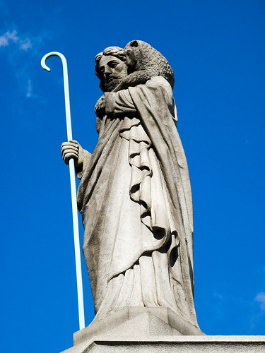
Tales of Calvary 10- The Hatch

– photo by Mitch Waxman
Your humble narrator, amongst other failings, has a certain preference for the grandiose statuary of the late 19th and early 20th century at First Calvary Cemetery here in Queens. Baroque expressions such as these appeal to the comic book fan in me, looking for all the world like a Jack Kirby or Jim Steranko rendering. One half expects a concrete angel to… well, I stray…
– photo by Mitch Waxman
The southern section of First Calvary, found atop the cyclopean masonry observed on Review Avenue, offers glimpses of the Newtown Creek and panoramic views of industrial Brooklyn. Framing the open horizon of marshy western Queens and the forges of Brooklyn is the Kosciuszko Bridge, heroically carrying a vehicular river called the Brooklyn Queens Expressway over the infamous cataract. The elevation of these walls is actually quite high, an arcing and non euclidean structure which must be 2 to 3 stories at its apogee.
Am I overestimating? Check out this shot from the “street level” declination, aimed at the downward slope from halfway down Review Ave.–
And the shots below are from the other side of it, the topside of the wall.

– photo by Mitch Waxman
You won’t find the grandiose tombs or obsequious monuments to the famous on this side of First Calvary. This is where the “regular people” are buried- in their multitudes- in neatly defined rows of plots. The northwestern sections of Calvary, where the main gates are, and the northeastern- along Laurel Hill Blvd.- (both “High Ground”) are where you can find the princes of the 19th century city. Here, along Review Avenue, is where the middle and working class rest.

– photo by Mitch Waxman
My reasons for coming to this section must remain hidden, for now, suffice to say that I am still hunting for the grave of a man named Gilman (see “Tales of Calvary 7” for more speculation on this mysterious merchant from Massachusetts). Enjoying the relative quiet, I noticed one of the concrete pillboxes which I’ve also alluded to in earlier posts. These structures are all over Calvary, are often padlocked, and have aroused no small amount of curiosity in your humble narrator.

– photo by Mitch Waxman
Several conjectures -an access point to buried family mausoleums, a storage unit for groundskeepers, some sort of equipment shed- have assailed me as I observed these structures with their heavy iron lids and stout cement construction. An avid devotee of the macabre, I’ve often wondered aloud about just what is is that may be down there.

– photo by Mitch Waxman
This particular structure, as you can see, had been left unlocked. In fact, its heavy lid was just resting on the cement and its hinges had long ago stopped functioning.

– photo by Mitch Waxman
Nudging the lid back a few inches, a better than six foot drop was observed, which put its bottom some 4 feet below the surface as observed in the shot above. I activated the camera flash and illuminated quite a bit of airborne dust when the camera performed its intended action. As you can see, there were two modern shopping carts and part of a lamp down there. Puzzling- not for being trash, but… for… why, how, when, etc. You’d expect shovels or spades, but shopping carts and a lamp?

– photo by Mitch Waxman
Were I still the youthful and robust physical specimen I once was, I might have more to say about this, as I would have entered the yawning mystery for a closer look. However, as an aged physical coward and feckless quisling given to emotional stupor and irrational panic, the miasmal odor of the open hatch drove me backwards and I nearly passed into one of my episodes. Fighting off a faint, I labored to close the heavy lid and made for the Penny Bridge gates found on Laurel Hill Blvd. to escape the implications of that smell, which reminded me of an aquarium in need of filtration.
What can it be, that might be down there?
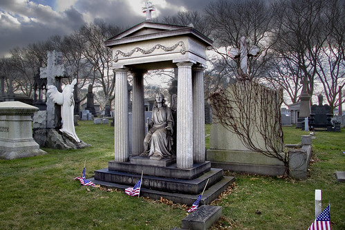
Tales of Calvary 9- A Pale Enthusiast

– photo by Mitch Waxman
Amateurish and lazy explorations of Calvary Cemetery and the Greater Newtown Pentacle, with associated blog postings foisted upon an unsuspecting public and amplified by a never ending barrage of self promoting debasements of all that is true, have revealed many strange things to your humble narrator, and by extension- to you my gentle lords and ladies of Newtown. Today, the Doherty monument in First Calvary gets its turn. There is nothing “odd” about the monument, in fact the reason I call attention to the thing is the supernal beauty of its working. This is one uncanny bit of carving, and unfortunately these photos do not do it justice (still adjusting to the new camera).
Art school faculty, turtlenecked and smoking french cigarettes, would probably describe it as “Sophia, goddess of wisdom- in the form of a christian angel, sitting within a Roman structure, crowned by a cross- representing an agglutination of civilized democratic-christian progress advancing since the time of the Greeks and the Roman Republic and ultimately manifested as The United States. The angel casts her eye skyward, vigilant, with a sword in her hand. A pacific and expectant expression suggests the nearness of the second coming and resurrection of the dead.”
Such imperious and hyperbolic thinking was very much in vogue in the years between 1900 and the first World War.

– photo by Mitch Waxman
Eugene Doherty and his wife Mary J. Doherty are buried here. Their headstones have bas reliefs of palm fronds draped across them. The little flags are planted at the graves of military veterans in New York Cemeteries on national holidays to honor their service. I found no evidence of Doherty serving in the military, but that probably just means I didn’t know where to look.
After all- I’m just some ‘effed up lunatic who spends his spare time scuttling around trash dumps, toxic waste sites, and cemeteries who gets his kicks bad mouthing the past- Right?
– photo by Mitch Waxman
Mr. Doherty, it seems, was a man of some reknown. He was a leading member of the Irish community on both sides of the Newtown Creek, and stood shoulder to shoulder in prestige alongside Battle-Ax Gleason in the eyes of his countrymen.
A manufacturer of rubber, Doherty specialized in the sort of material demanded by “turn of the 20th century” Dentists for the manufacture of dentures. His heavily advertised (see sample at bottom) Samson Rubber was a standard component for the manufacture of false teeth. The factory, incorporated as Eugene Doherty Rubber Works, Inc., was located at 110 and 112 Kent Avenue which is in Greenpoint (or Williamsburg, depending on whether or not you’re trying to hard sell a building).
rubber, from wikipedia
The major commercial source of natural rubber latex is the Para rubber tree (Hevea brasiliensis), a member of the spurge family, Euphorbiaceae. This is largely because it responds to wounding by producing more latex.
Other plants containing latex include Gutta-Percha (Palaquium gutta),[1] rubber fig (Ficus elastica), Panama rubber tree (Castilla elastica), spurges (Euphorbia spp.), lettuce, common dandelion (Taraxacum officinale), Russian dandelion (Taraxacum kok-saghyz), Scorzonera (tau-saghyz), and Guayule (Parthenium argentatum). Although these have not been major sources of rubber, Germany attempted to use some of these during World War II when it was cut off from rubber supplies. These attempts were later supplanted by the development of synthetic rubbers. To distinguish the tree-obtained version of natural rubber from the synthetic version, the term gum rubber is sometimes used.
A neat image of the the Doherty Rubber Works building late in its heyday (1920) can be found at trainweb.org, if you can believe anything I say, and they have a great description of the whole scene in context here. I warn you though, you’re going to learn about the Brooklyn Eastern District Terminal!
Also, in a completely unrelated coincidence, NAG is located at 110 Kent in modernity. Here’s the place on a google map, click “streetview” to compare to the 1920 shot above

– photo by Mitch Waxman
Eugene Doherty died in 1906, his wife Mary in 1914. Luckily for Mary, the denture business was a lucrative one, and her years of mourning were spent in material comfort. At her death, she bequeathed the staggering sum of $621,148 to her heirs.
$621,148 in 1914, mind you, and federal income tax had just become a reality in 1913. That’s at least $10,000,000 in modern coine.

– photo by Mitch Waxman
Life sized, if you’re a 5 foot tall woman, the statue itself is disarming and has weathered existence in the corrosive atmospheric miasmas extant about the nearby Newtown Creek for 94 years, only losing a thumb. The colour, oddly, doesn’t stain sanctified Calvary. Xanthian skill representative of true artistry went into the shaping of this stone, but I haven’t been able to find the name of the sculptor in public record.
If you see it, stand close and look into its eyes, then leave when the chills begin. Whatever you do, don’t look back over your shoulder at it afterwards, lest an adjusted hand hold on the sword, or the impression that the angle of its head has shifted might be seen. Remain an observer- in Calvary- ever the pale enthusiast- ever an Outsider.
Hey, you never know what you’re going to find at Calvary Cemetery.
Also, just as a note- today, January 13th, is Clark Ashton Smith’s birthday, and St. Knut’s Day as well.
Eugene Doherty Rubber Inc. - Late 19th/Early 20th century Advertising
The Newtown Creek Community Health Harm Narratives Project

– photo by Mitch Waxman
Andrea Muraskin of the CHHNP asked if I could post this and help get the word out about this project, all text by CHHNP-
Attention Residents of Greenpoint, East Williamsburg, and Maspeth:
Are you worried about health problems caused by the pollution in your neighborhood?
Would you like the opportunity to tell your story?

– photo by Mitch Waxman
If yes, then you may want to be interviewed for a community health project that aims to document the public health concerns of individuals residing in communities along Newtown Creek in NYC. If you live, or have ever lived in Greenpoint or East Williamsburg, Brooklyn or Maspeth, Queens, you are invited to participate in the Newtown Creek Community Health and Harm Narrative Project, as study which hopes to capture residents’ experience with illness and environmental pollution in their neighborhoods.
Participation will provide you with an opportunity to have your story documented in your own words. With your permission, the information you disclose will be displayed in written and audio format on the website http://www.habitatmap.org and in a written report that will be disseminated to community members, media outlets, elected officials, and other interested parties.

Community involvement is important. Make your voice heard!
If you have any questions or are interested in participating, please contact Yvonne Kodl at:newtowncreekstudy@gmail.com or
(718) 566-1359.
Please note: The study is in the concluding portion of its interview phase. If you are interested, please contact us as soon as possible.
The Newtown Creek Community Health and Harm Narrative Project is a collaboration between the Urban Public Health Department of Hunter College, HabitatMap, and the Newtown Creek Alliance.
Media Links
Television: Brooklyn Community Access Television ,
Radio: Leonard Lopate on WNYC
Newspaper: NY Daily News http://www.nydailynews.com/ny_local/brooklyn/2009/06/22/2009-06-22_newtown.html
Blog:http://www.nylcv.org/ecopoliticsdaily/20091112_newtown_creeks_neighbors_speak_out_on_health_concerns

– photo by Mitch Waxman


