Archive for the ‘Long Island City’ Category
Wow, Forgotten Queens Plaza
Just read an awesome forgotten-ny page walking through Queens Plaza and environs. Check it out here.
Hook and Ladder 66

-photo by Mitch Waxman
Just off the corner of Steinway is 38-13 Northern Blvd. It stands opposite the cyclopean Standard Motor Products building, and at the foot of the bridge which carries Steinway into 39th street and south to Skillman Avenue over the Sunnyside Yards. Currently, the structure houses part of the NYPD’s ESU units- the Emergency Medical Squad. The building was originally a firehouse- the Hook and Ladder 66.
The earliest volunteer fire company in Newtown was organized in 1843- the Wadownock Fire, Hook & Ladder No. 1. By 1902, there were 66 distinct volunteer fire departments in Queens. 19th century Long Island City was served by (amongst others) the Astoria Engine Co., the Hunter Engine Co., the Mohawk Hose Co., and the Tiger Hose Co. In 1890, the legislature of New York State abolished the volunteer departments, seeking to create a paid and professional force of firefighters. In Long Island City, as many as nine units were created, and then reorganized in 1894, as rampant political corruption had rendered the new units impotent against all but the smallest blazes. This corruption was centered around Long Island City’s mayor- Patrick “Battleax” Gleason- or was at least blamed on him by his enemies in the press.
The critical date for this story is 1898, when Long Island City joined in the municipality of the City of Greater New York, and its firefighters joined the FDNY.

-photo by Mitch Waxman
In 1900, FDNY Commissioner JJ Scannell proposed a sweeping expansion of fire service citywide, but especially in underserved Long Island City. The “Board of Estimate and Apportionment” was asked to make funds available for infrastructure- specifically fire houses. Built concurrently with the landmarked Engine 158 fire house at 10-40 47th Avenue, the building was budgeted to cost $18,000 to build and complete in 1901, but ended up costing $23,000 when it was dedicated in 1905. The architecture firm which built it was Paris & Schroeder, who designed the Bowery YMCA and many other Tammany projects. Along with the Engine 158 structure, this building was designed and overseen by Ernest Flagg and Bradford Lee GIlbert. Check this link out, for some local FDNY color from 1899.
Ernest Flagg at wikipedia
Beaux-Arts Architect and Urban Reformer
Mardges Bacon
Architect of the United States Naval Academy, the Corcoran Gallery of Art, the Scribner Building, and model tenement houses, Ernest Flagg (1857-1947) advanced the cause of classicism while demonstrating a deep concern for architecture’s social responsibility. This study of one of the most innovative practitioners of the Beaux-Arts movement in America covers Flagg’s early training and Beaux-Arts works, his town and country houses, his commercial and utilitarian buildings, the Singer Tower (which established a new height record while setting a precedent for New York City skyscraper restrictions in scale and density), urban housing reform, and his small houses of modular design.
Flagg, the author notes, combined French nineteenth century aesthetics and the principles of academic classicism with American structural technology to create significant buildings during the Progressive Era from 1890 to 1917. His contributions to zoning and height regulations were essential to New York’s first laws governing this aspect of the city’s architecture. A confirmed individualist, Flagg produced highly original writings and ingenious inventions for construction techniques in low-cost housing and railroad cars.
Flagg’s adaptation of classicism and his concern for urban contextualism make this study of his work particularly timely. His designs have immediate relevance for contemporary architects and preservationists, as well as those interested in the social and architectural history of New York City.
Pictures & Flagg’s plan to extend Manhattan’s grid
Courtesy of Bradford Lee Gilbert.com
Bradford Lee Gilbert
(March 24, 1853 – September 1, 1911)
Bradford Lee Gilbert was born in Watertown, New York to parents Marie Antoinette (Bacon) and Horatio Gates Gilbert. Mr. Gilbert was well educated having attended Sedgwick Institute, Gt. Barrington, Siglar’s School, Newburg, Irvington and Yale College.
He was a member of the New York Chapter of American Institute of Architects, The National Sculpture Society, The Architectural League, The National Arts Club, The Transportation Club, The Quill Club, The Riding Club, and The Chicago Club.
Mr. Gilbert enjoyed many distinctions, but was a driving force in the growing railroad industry. He was the consulting architect to eighteen of the principal railroads in America, and was appointed as official architect to the New York, Lake Erie and Western Railroad under Octave Chanute (who assisted in the Wright Brother’s creation of airplanes).
Mr. Gilbert played a major role in other railroad companies like, the enlargement to the first Grand Central Station in New York; the Illinois Central Station in Chicago, Illinois; the Boston & Maine Union Station in Lowell, Maine and many others.
Bradford passed away in Accord, Ulster County, New York of Dropsy.
One of the few buildings attributed to him that wasn’t part of a railroad

-photo by Mitch Waxman
In January of 1913, all Brooklyn and Queens fire companies had their unit numbers moved forward by 100- thus Engine 158 became 258. Hook and ladder 166’s history gets a little hazy in the intervening years, and a unit with the 166 designation seems to still be extant in Brooklyn- but the history of the FDNY is best discussed by experts. At some intervening point in the last hundred years that I have not been able to pin down (most likely the early 80’s), the building passed into the hands of the Police department which assigned its ESU NYPD Emergency Medical Squad to the premise. They are the current stakeholders, in this part of the Newtown Pentacle.
ESU are the Green Berets of the NYPD, assigned the most challenging and dangerous jobs. Most are former United States Special Forces or U.S. Marines who bring ingenious skills and hard won experience to work every day. If you are in real trouble in New York City, the ESU is your personal Batman. Two fully loaded paramedic ambulances and a variety of specialized response vehicles are based here. ESU medical is commanded by a 35 year NYPD veteran and former Marine, Chief of Special Operations Charles D. Kammerdener.
7/19/09 Note and addendum: Queenscrap ran a blog post about this article, and “anonymous” posted this in their comments:
Ladder 66 is now Ladder 116 (all companies renumbered in 1913 after NYC expanded, the E158 house is really Engine 258)
The Ladder Company that occupied this Northern Blvd house is now located on 29th St near 37th Ave and was quartered with Engine 261 for over 80 years until “King Bloomberg” closed E261 in May 2003
Dutch Kills, or let the Photos do the Walking
Anything you may experience, in situ, by following these walking directions is at your OWN RISK, and is offered by the Newtown Pentacle for documentary and entertainment purposes only. Remember- the rule we follow at the Newtown Pentacle is to NEVER trespass. Like Vampires, Newtownicans should wait to be invited into a house before they can do their work. To wit.
Feel like taking a walk? I’ll show you something cool… Bring your camera- and ID

Truck at 47th avenue and 28th street, Long Island City -photo by Mitch Waxman
from wikipedia
Dutch Kills is a sub-division of the larger neighborhood of Long Island City in the New York City borough of Queens. It was a hamlet, named for its navigable tributary of Newtown Creek, that occupied what today is centrally Queensboro Plaza. Dutch Kills was an important road hub during the American Revolutionary War, and the site of a British Army garrison from 1776 to 1783. The area supported farms during the 19th Century, and finally consolidated in 1870 with the villages of Astoria, Ravenswood, Hunters Point, Middletown, Sunnyside and Bowery Bay to form Long Island City.
Dutch Kills is one of the extant branches of the Newtown Creek, and located not too far from the Degnon Terminal complex (part of the Sunnyside Yards).
Get to 47th avenue and 28th street, early morning or late afternoon are probably best because of the whole sunlight east west thing. Weekends are good because there is a lot less going on in the industrial zones of the Newtown Pentacle.
Assuming you’re coming from the north (skillman or thomson avenues)- You’ll find a series of construction sites behind and to the left of you, and a cement factory (New York Concrete Supply)in front of you. Cross the street and make a left. Look west, and you’ll be reassured by seeing Manhattan.
I’m going to say this over and over- but be REALLY MINDFUL OF TRUCKS, and… be a smart new yorker- if you’re snapping pics and a guy who looks just like a mobster walks in front of you in Long Island City- He doesn’t just look like a mobster- HE IS A MOBSTER. Don’t be a schmuck.
View Dutch Kills in a google map

Concrete Trucks on 47th avenue, Long Island City -photo by Mitch Waxman
Walk to 29th street, which is a very dangerous place for pedestrians. BE CAREFUL. There is no sidewalk, and it is a shortcut to Thomson Avenue and Queens Blvd for traffic coming off the LIE. To your right is Dutch Kills, at its terminus. By the way, the concrete guys REALLY don’t like having their pictures taken.

Concrete Trucks on 29th street, Long Island City -photo by Mitch Waxman
Make the right at the corner of 29th street. DO NOT CLIMB DOWN ON TO THE RUSTY BARGE, you will get hurt and fall into the water with an open wound. When you smell the water, you’ll understand my warnings. 29th street is VERY dangerous. Lots of great Creek kind of shots, but mind yourself, there’s better stuff ahead with safe vantage points.

Dutch Kills from 29th street -photo by sweetpea212– a member of our Newtown Pentacle Flickr group
All along the Newtown Creek, there are abandoned barges and other vessels. This particular one has been sitting here for at least 3 years. Resist the urge, urban explorers, its not worth it. Also, note the storm sewer in the center of the above shot.

Structure I am desirous of having a chance to get inside legally, with my camera -photo by Mitch Waxman
At the other end of 29th street- Welcome to an insanely dangerous parking and loading dock for the crumbling Hunterspoint Steel building.
Big old factory on Hunters Point Avenue, has severed rail tracks and abandoned waterfront loading docks. Has a “for sale” sign on it. Perfect lair for supervillian, close to highway and trains.
from trainsarefun.com:
track map as of 1966 for the area- legend is
7 Staley Elevator 8 Conran Supply 9 Best Wholesale 9a Masbrook Wholesale 9b Saxon Paper 10 Principe Danna 11 Sunshine Biscuit (Garage) 12 Sunshine Biscuit (Factory) 13 Bell River Corp. 14 American Chicle Corp. 15 Equitable Paper Corp. 16 Wheeling Corrugated 17 Gimbel Bros. 18 R.H. Macy 19 Simons 20 Concrete Steel 21 Phillip A. Hunt 21a Saxon Paper 22 Standard Wine & Liquor 23 Harrison Building 24 J.H. Rhodes 25 Hunters Point Steel 26 Standard Folding Box Company 27 United Parcel 28 Star Liquor 29 Viking Criterion Paper

CAREFULLY cross Hunter’s Point Avenue and make a right. Proceed to the Hunters Point Avenue Bridge.

Water the color of Tea, from Hunters Point Avenue Bridge -photo by Mitch Waxman
Hunters Point Avenue Bridge. Stop and look around. Take pictures- this is a great vantage point. This is the place you are also most likely to exchange friendly greetings with law enforcement or private security. Be nice, smile- you’re not doing anything wrong- and you even remembered to carry ID.

Water the color of antifreeze, from Hunters Point Avenue Bridge -photo by Mitch Waxman
Most of the cops who’ve pulled over and asked me what I’m up to are just doing their job. So are we, lords and ladies of Newtown.
The Police respond to fear and anger in ways injurious to your freedom. You be nice, and so will they. Its really not an adversarial encounter unless you make it so. If they’re jerks, insist on a supervisor or superior officer’s involvement (which may mean a trip to the station house- adventure!). Young cops are zealous and eager to enforce, older cops don’t want their retirement to get jammed up with a civil rights case. An older cop will also realize that you’re “harmless” faster than a young one.
Here’s a great description of your rights as a photographer. Besides, the commish has already pronounced NYPD’s stand on photography.

Dirty Birds, from Hunters Point Avenue Bridge -photo by Mitch Waxman
The Hunters Point Avenue Bridge over Dutch Kills is a Bascule bridge.
from the NYC.gov DOT website:
Easily the most popular type of movable bridge in existence today, bascule bridges are designed to pivot on a fixed axis. Usually this type of bridge consists of movable ‘leaves’ fixed to each end of the channel. The leaves are precisely counterbalanced by weights of sufficient size that relatively little motor power is required for their operation – usually just enough to overcome inertia, frictional resistance, wind and snow loads.
Bascule bridges are simple and speedy to operate, and because of the relatively small amount of electricity needed for movement, cost efficient.
The Hunters Point Avenue Bridge offers spectacular views north and south. That’s the concrete factory from the first photos in the distance.

from Hunters Point Avenue Bridge looking north -photo by Mitch Waxman
There’s a surreal beauty to this tributary of the Newtown Creek, an isolated loneliness. It’s a dead place, the corpse of a mighty age of enterprise.

from Hunters Point Avenue Bridge, looking north -photo by Mitch Waxman
Looking north, the LIE bridges the Dutch Kills.
Yes, these trees and plants are hideously overgrown and show all the signs of having been fed from some morbid nutrition. There is a tenebrous darkness that radiates about them… I know. The fact though, is that if you give nature just a little time, even here in the home of the darkest industrial mills… It’s kind of a nice idea- isn’t it- rebirth.
from Queens Borough, New York City, 1910-1920
During 1914 bulkhead lines were established by the United States Government for Dutch Kills Creek, a tributary of Newtown Creek, thus putting this stream under the jurisdiction of the War Department. The bulkhead lines as approved on October 29, 1914, give a width varying from 200 feet at its junction with Newtown Creek to 150 feet at the head of the stream, and include a large basin in the Degnon Terminal where car floats can be docked. The widths of the channel to be dredged under the appropriation of $510,000 mentioned previously, range from 160 feet at Newtown Creek to 75 feet at the turning basin. The Long Island Railroad plans to establish at this point a large wholesale public market, estimated to cost nearly $5,000,000.
Among the larger industrial plants in the Degnon Terminal served by this stream are : Loose Wiles Biscuit Company, American Ever Ready Works, White Motor Company, Sawyer Biscuit Company, Defender Manufacturing Company, Pittsburg Plate Glass Company, Marcus Ward, Brett Lithograph Company, Waldes, Inc., Norma Company of America, Manhattan-Rome Company, American Chicle Co. and The Palmolive Co.

from Hunters Point Avenue Bridge, looking southeast -photo by Mitch Waxman
Continue down Hunters Point Avenue and make a left at 27th street. (as of 6/27/2009- intersection at Borden still closed due to bridge reconstruction).
A fantastic series of abandoned industrial buildings are on the left. Photograph quickly, Newtownicans, these are being torn to shreds by those dastardly developers right now.

Creek Car, from 27th street -photo by Mitch Waxman
My favorite spot on these 3,000 feet in Queens is (was) undoubtedly the corner of Borden Avenue and 27th street. On your right is an abandoned strip club called Infinity, in front of you is the Borden Avenue Bridge, to your left and below is the Dutch Kills, above you is the LIE.

Water the color of ice -photo by Mitch Waxman
The west bank of Dutch Kills was always an easy shot for me in the mornings and early afternoon. Unfortunately, the construction of the coffer dam for the bridge reconstruction has removed many of the charismatic and idiosyncratic features I’m so drawn to. What foul battrachian horrors might lurk in the slime down there, and who can guess what it is that the construction might have stirred up?

Same vantage as above, in a different season -photo by Mitch Waxman
Ghosts are found here. Phantoms of the clear eyed mariners who inhabited this world, drifting by in wooden ships. Protruding from cement and clinging mud alike are the skeletal remains of rail lines which led from factory floor to dock, defining both building and waterway. Every fallow and abandoned spot finds nature battling to rescue her ruined child from the degradations heaped upon it.

And they built a giant steel highway 106 feet over it.-photo by Mitch Waxman
The pacific quality of the water in these photos, with their mirror like reflectivity, actually betrays a numbing truth. The stillness of the water in this crumbling canal allows it to steadily accrete a sedimentary ichor of pollutants which cake the shorelines, and its percentage of dissolved oxygen is so low that these opaque and stench producing depths can be described as stagnant and injurious to life.
Denied the curative effects of erosion, as provided by strong tide and swift current, the concentration of pollutants here seems worse than anywhere else on the Newtown Creek waterway- except for the lamentable Maspeth Creek. Floating poop is the least of it, there’s lead and arsenic and dioxin in that mud. Who can guess it is that might be breeding down there? What foul congress of poisons awaits the future?
from an army corps of engineers documeent discussing precautions for the collecting, handling, and testing of Dutch Kills sediments:
All individuals involved in handling contaminated sediment are required to use protective equipment and to submit to blood and urine tests. The protective equipment consists of:
from nycroads.com
BEGINNING OUT OF THE TUNNEL: The first section of the Long Island Expressway, a one-mile-long, six-lane viaduct over Long Island City, Queens, opened to traffic in 1940 after one year of construction. The new viaduct, whose opening coincided with that of the twin-tube Queens-Midtown Tunnel at its western terminus, had its eastern terminus at the new Brooklyn-Queens Expressway (I-278). At its highest point, the viaduct rises 106 feet above Dutch Kills

Borden Avenue Bridge -photo by Mitch Waxman
Well, here we are, on the Borden Avenue Bridge. Check out these flashy drawbridge lights. Isn’t that cool? Told you I’d show you something cool…
from the DOT website on the history of the Borden Avenue Bridge, which spans Dutch Kills.
Borden Avenue is a two-lane local City street in Queens. Borden Avenue runs east-west extending from Second Street at the East River to Greenpoint Avenue. The Borden Avenue Bridge over Dutch Kills is located just south of the Long Island Expressway between 27th Street and Review Avenue in the Sunnyside section of Queens. Borden Avenue Bridge is a retractile type moveable bridge. The general appearance of the bridge remains the same as when it was first opened in 1908. The bridge structure carries a two-lane two-way vehicular roadway with sidewalks on either side. The roadway width is 10.5m and the sidewalks are 2.0 m. The west approach and east approach roadways, which are wider than the bridge roadway, are 15.3m and 13.0m respectively. The bridge provides a horizontal clearance of 14.9m and a vertical clearance in the closed position of 1.2m at MHW and 2.7m at MLW.
As part of the construction of Borden Avenue in 1868, a wooden bridge was built over Dutch Kills. This bridge was later replaced by an iron swing bridge, which was removed in 1906. The current bridge was opened on March 25, 1908 at a cost of $157,606. The deck’s original design consisted of creosote-treated wood blocks, with two trolley tracks in the roadway. Character-defining features of this bridge include the stucco-clad operator’s house, four pairs of rails, and a rock-faced stone retaining wall. The gable-on-hip roof of the operator’s house retains the original clay tile at the upper part. Although alterations have been made, the bridge is a rare survivor of its type and retains sufficient period integrity to convey its historic design significance.
The bridge will be closed for construction through July 2009. In addition, there will be parking restrictions in the vicinity of the bridge from January through July 2009 at all times from 25th Street to 30th Place between Borden Avenue and Hunter’s Point/49th Avenue and from 50th Avenue to 51st Avenue between 27th Street and 25th Street.

There are also two LIRR rail bridges, visible from Borden Avenue, which are articulated (moving) across the Dutch Kills. Shot taken from upon the waters of the Newtown Creek looking North -photo by Mitch Waxman
Newtown Grafiti
Ms. Heather over at NYshitty recently ran a piece on some interesting runic grafiti found in Greenpoint, Brooklyn. Examination by her extensive network revealed a sinister meaning to the appearance of these runes. Connections to the late 19th century German mystics and conjurers who inspired Hitler’s Wagnerian mythos emerged.
As I’ve ambled across the Newtown Pentacle in the last few years, I too have noticed odd grafiti that hints of esoteric knowledge. My interests and studies have crossed the left hand path more than once, and I have the eye of one acquainted with an iconography of the occult. The Pentacle is steeped in magick all the way back to the Dutch.
This makes sense, as the pastoral shamanism of the Koreans and the ghost worshipping of the Catholics stands cheek by jowl with Nestorian Christianity and the Yesidi clan of Kurdish devil worshippers (here’s one of their holy books- I shit you not). Mohammedan or Hasid, Presbyterian or Hindoo, all the mainstream faiths in the area have thrown great spires at the sky and filled the socratic skyline with their particular “gnosis”. The one thing all these people have in common, other than problems with subway service, is that every one of these churches has its apostates. The Catholics have Opus Dei, and the Muslims have the Sufists.
Groups of true believers who think that the “big church” has lost its way, these philosophies offer hidden truths and revelation. Cults, or as we might say it in modern newspeak- “self organizing grass roots gatherings of religious enthusiasts”. Often, these cults form within gangs. The South American and Mexican gangs, in particular, are known to employ magicians called “Padrinos” to amplify their advantages in hostile encounters. If you believe in magick, it works. They do.
In February of 2009, during a religious ritual in Flushing, a 6 year old was burned with “accelerants”. Invocations of a Loa often involve spitting flaming rum at the intended participant of the ceremony. Santeria (and its black magick equivalent- Palo) also employs similar magickal techniques and symbology.
Also… how does Aleister Crowley always end up getting into the mix? The goetia, which that nasty man said was “the Lesser Key of Solomon” contains ritual sigil designs that are very similar to designs found appearing all over Astoria since mid 2007. A better thing to read, would be this. Seriously, this is the craziest thing you’ll see today. Ok, maybe this is.
If you’re interested in this sort of thing, I would suggest reading up on the Rosicrucians, The Order of the Golden Dawn, Madame Blavatsky and the Theosophists, and the 19th century Spirititualist movement. Compare with the “model tenement” movement, John Harvey Kelogg, and eugenics. The occult inheritances of these debauched philosophies have filtered out into popular culture as Veganism, New Age Movement, Alcoholics Anonymous and the Recovery Movement, and a series of badly spellchecked grimoires which all refer to themselves as “the Necronomicon”.
At the end of the 19th century, occult topics played well in the absinthe fueled cocktail party culture of the middle class- the “sustainable living” and “green technologies” conversations of their day.
First, there is a difference between grafiti and occult markings. These are grafiti.

Ravenswood- This is a “tag”, a kind of grafiti which is painted or etched with differing levels of artistic merit. Often, taggers will “bomb” a neighborhood, leaving behind dozens if not hundreds of iterations of their particular icon. Often the tag will refer to gang or ethnic affiliations -photo by Mitch Waxman

Sunnyside Yards Honeywell Bridge Tag. The top right looks sigili-ish, but the 187 (police code for an undercover cop in trouble) indicates this is New York Street culture oriented -photo by Mitch Waxman

Street work painted by DOT. An amazing coincidental drawing of a theoretical tesseract or hypercube -photo by Mitch Waxman
The next two are Latin Kings tags. No affiliation or hate.

Astoria Latin Kings tag -photo by Mitch Waxman
I hesitate to post anything about… umm… self organizing fraternal societies of urban youth- but these are Latin King tags. The number of points in the crown has some significance which I am ignorant of, the presence of circles amongst the points which indicates political standing or factional allegiances of the tagger to the citywide organization is also something I am completely ignorant about. Go ask a King.

Woodside Latin Kings tag -photo by Mitch Waxman

Dutch Kills abandoned factory: Part of a series of enigmatic scrawls found in a muddy place where no footprints could be seen -photo by Mitch Waxman
Now, either by design or accident of design- the occult::

This is in one of the isolated spots in Long Island City. Similar to Ms. Heather’s runes, these are under the LIE and over the LIRR in Long Island City, behind the midtown tunnel -photo by Mitch Waxman

Mt. Zion altar. Found this on 59th street while walking the Mt. Zion cemetery fenceline. It was a little wooden mortar and pestle with coarse gray ash inside of it. There was candle wax as well -photo by Mitch Waxman

This is a fairly modern, post-industrial era sigil representing the demon Asmodeus. Lamp pole in Astoria -photo by Mitch Waxman

Astoria, chaos dragon/snake mother sigil. Compare with the ancient Naga of the Mahabharata -photo by Mitch Waxman
and another one, miles away in Ravenswood-

Ravenswood Sigil -photo by Mitch Waxman
Obviously the work of a small group or possibly even one person, this next grouping started turning up all over astoria since middle 2007. The one with my shadow in it is in Maspeth, by an abattoir.

Occultish grafiti found along the fenceline of a gigantic Korean Church -photo by Mitch Waxman

Occultish grafiti found in Astoria -photo by Mitch Waxman

Occultish grafiti found in Astoria -photo by Mitch Waxman

Occultish grafiti found in Maspeth -photo by Mitch Waxman

Occultish grafiti found in Astoria -photo by Mitch Waxman

Occultish grafiti found in Astoria -photo by Mitch Waxman

Graphomania like this is all over the place, and gets denser as you travel toward Corona and Roosevelt. Most likely a mexican or ecuadorian fraternal group. Read the text from multiple angles and directions. Correct orientation will be apparent to members. Standard fenceline style of code -photo by Mitch Waxman

Occultish grafiti found in Greenpoint -photo by Mitch Waxman
Of course, Queens being Queens… some things require little or no explanation

Dutch Kills -photo by Mitch Waxman
A Big Dig in Queens
Sorry for the quotidian nature of parts of this post, but if someone says it better and more succinctly than you can- just acknowledge and accredit the source I always say.

Sunnyside Yards, Degnon Terminal- photo by Mitch Waxman
An Observation:
Good old fashioned “Progress” is on the move again in the City of Greater New York.

Sunnyside Yards, from Skillman Avenue- 3 exposure HDR photo by Mitch Waxman
Along the east side in Manhattan, a new subway line is under construction. The project has called for an expansion of the Long Island Rail Road’s cyclopean Sunnyside railyards at the Degnon Terminal here in Queens. (ps- check this video of a ride on the 1950’s Manhattan Third Avenue El at YouTube).
Quoted content from trainsarefun.com
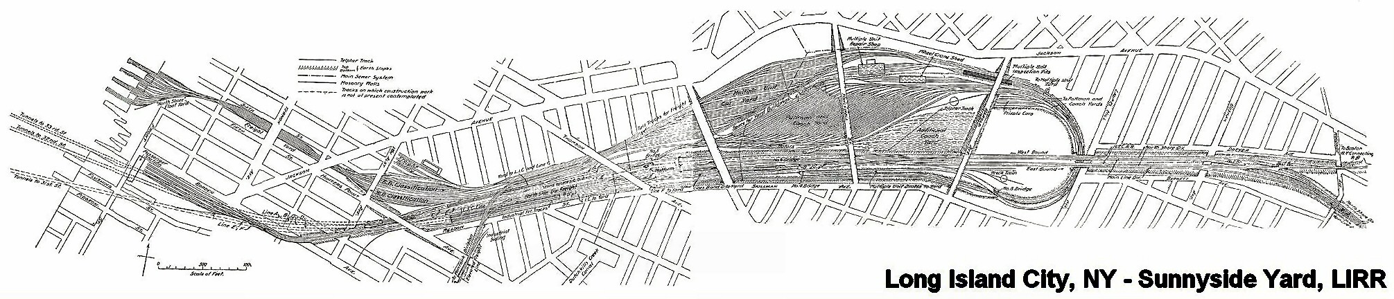
Sunnyside Yard Rendering C. 1905
In 1910 the Pennsylvania Railroad had completed its terminal in New York City, which was connected by tunnels to New Jersey, and under the East River to Long Island. At Sunnyside the large yard of the Pennsylvania Railroad was constructed. An agreement was made with that Railroad and the Pennsylvania Tunnel and Terminal Railroad Company whereby the cars of the Long Island Railroad would be carried through the tunnels under the East River into the Terminal at Seventh Avenue and Thirty-second Street, New York. Thus the Long Island Railroad acquired what successive administrations had striven for in vain, a terminal on Manhattan Island. In order to reach this terminal it was necessary to electrify from Jamaica to New York, which was accomplished in 1910, and the first train run into the Pennsylvania Station on September 10th of that year.
-Felix E. Reifschneider’s 1925 Long Island Rail Road History
I REALLY have to recommend some time spent at Trainsarefun.com for any antiquarian, and especially for the intrepid photographer trying to peel back a few layers. This is one of the best collections of old photos and maps on the Long Island City and Newtown Creek industrial complexes that I’ve found so far. Wow. This is the link to their LIC page (same as one on accredidation).

Sunnyside Yards, Degnon Terminal- photo by Mitch Waxman
The Plan:
as quoted (verbatim) from the wikipedia article on the subject:
Extending between Sunnyside, Queens, and Grand Central Terminal, the East Side Access project will route the LIRR from its Main Line through new track connections in Sunnyside Yard and through the lower level of the existing 63rd Street Tunnel under the East River. In Manhattan, a new tunnel will begin at the western end of the 63rd Street Tunnel at Second Avenue, curving south under Park Avenue and entering a new LIRR terminal beneath Grand Central Terminal.
Current plans call for 24-trains-per-hour service to Grand Central Terminal during peak morning hours, with an estimated 162,000 passenger trips to and from Grand Central on an average weekday. Connections to AirTrain JFK at Jamaica Station in Jamaica, Queens, will facilitate travel to John F. Kennedy International Airport from the East Side of Manhattan.
A new LIRR train station in Sunnyside at Queens Boulevard and Skillman Avenue[1] along the LIRR’s Main Line (into Penn Station) will provide one-stop access for area residents to Midtown Manhattan.[2] The station may spur economic development and growth in Long Island City.
A comment:
Once again, the recurring theme of “spurring development and growth in Long Island City” emerges. Look at the photos here at the Newtown Pentacle, go to our flickr group and see what other people are compelled to record and share. Does this place look undeveloped or undergrown? These are real estate interests talking, trying to grab away what remains of New York’s industrial infrastructure. These buildings are full of companies that employ people in low paying jobs that you don’t need a diploma or even ID to get. Greasy, necessary jobs handling garbage and other things you wouldn’t like to think about. Abattoirs and crematories are part of the story, like sewers and trains, of the greatest metropolis in the history of mankind.

Sunnyside Yards, Degnon Terminal- photo by Mitch Waxman
Minutia:
Degnon Terminal and the Sunnyside Yards are so large and obvious from the air, so critical to the economy and strategic operational capabilities of the United States- that they were designated by the Soviet Union’s Missile Forces as the first strike target in a nuclear attack on the New York Metropolitan area, not Manhattan (which is only a mile and half away, mind you, and would have been obliterated along with the yards).
– I’m trying to back that one up right now, but its something I read a while back- perhaps at conelrad, I’ll find my source on this- I just have to stop looking
-Astoria, incidentally, is where the famous “Duck and Cover” propaganda flick was made (here’s the youtube link).
Astoria and Sunnyside provided a large number of the 16,000 employees who worked here at the Degnon Terminal, almost all of whom belonged to labor unions. These were jobs “with benefits” like health insurance or paid vacations, a rarity before the late 1970’s. The shells of the titanic companies like Adams (Beeman) Chewing Gum, and Sunshine Biscuits line the streets surrounding the yard, but modernity has largely cut their links to it. These industrial buildings- filled piecemeal with dozens of smaller companies- load their containerized goods onto trucks, not trains, and the international port that will ship their products is in Newark, New Jersey.

Sunnyside Yards, this street corner is actually on a bridge over the yards- notice the change in elevation at lower left- still around 30-50 feet (10-15 meters) over the tracks– The structure at horizon is another road bridge over the yards. –3 exposure HDR photo by Mitch Waxman

Sunnyside Yards, Degnon Terminal- photo by Mitch Waxman
An opinion:
These sort of tectonic shifts in the landscape are nothing unusual in New York City, which is not so much a series of individual structures as it is an enormous complex of infrastructure whose every perspective is ultimately centered on Manhattan and whose borders ultimately lie hundreds, if not thousands, of miles away radiating in every direction including out to sea and in the air.

Sunnyside Yards, Degnon Terminal- photo by Mitch Waxman
Here in the Newtown Pentacle, near the very center of this Megalopolis– centuries of power, phone, water, and sewer systems weave around layered building foundations, abandoned trolley lines, and the legacy of the industrial revolution. Deep under the streets, streams and creeks that once ambled over the stubborn hills of New Amsterdam now crash through stone clad sewers in a century clad darkness, mixing with industrial runoff and raw sewage. Even under the best of circumstances, a lot of New York’s untreated waste ends up in the harbor. A significant portion of that dumping, by the City of New York, happens at Newtown Creek.

Sunnyside Yards, Queensboro Plaza Side, also a bridge over the yards- photo by Mitch Waxman
A warning:
In the very near future, vast new residential populations are envisioned to live nearby- at Hunter’s Point, and Queensboro Plaza, and all around the Sunnyside yards, if “growth is spurred”. I’m just an observer, but I’ve watched condo developers carving bloody chunks out of Long Island City, reducing enigmatic and functional structures down to a neighborhood eerily reminiscent of Battery Park City. These new developments are not required to improve the sewers, or build subway stops, or even compel the local electric company to improve the quality of its archaic grid. Can these ancient Newtown foundations support a magnified community they were never designed for?

Newtown Creek Bulkheads- photo by Mitch Waxman
On the waterfront(s), these waters flow into forgotten subterranean vaults, and flow through depression era landfills, swirling through long buried smuggler tunnels and abandoned building foundations on their pathway to the river– silt buried structures which await only the discovery of modernity. All the poisons which lurk in our Newtown mud leech into the water, eventually percolating into the East River and New York Harbor beyond.

Sunnyside Sewer- photo by Mitch Waxman
Who can imagine what might be buried down there, under all the layers of progress, and what the Big Dig in Queens might be stirring up?

Sunnyside Yards, Degnon Terminal- photo by Mitch Waxman
ps: Check out this video at Youtube for sound reasoning on why New York was the center of the universe– it’s Geography!
“Influence of Geography & History on Port of New York 1949”


