Archive for the ‘Long Island City’ Category
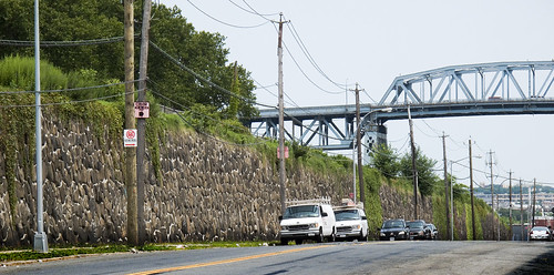
Greenpoint Avenue Bridge
A structure only a mother could love, the pugnacious span is also known as the J.J. Byrne Memorial Bridge.

From Review Avenue -photo by Mitch Waxman
Viewed from the street 0n Review Avenue, the Greenpoint avenue Bridge spans the Newtown Creek from Long Island City, Queens to Greenpoint, Brooklyn.
In Queens, Greenpoint avenue passes by Calvary Cemetery and changes its name to Roosevelt Avenue after it crosses Queens Blvd.
In Brooklyn, it remains Greenpoint Ave. all the way to the East River.
If it continued across the East River, it would intersect Manhattan at (the nonexistent) corner of 19th street and Avenue D. It’s 2.2 kilometers, or 1.37 miles from the mouth of the Newtown Creek at Hunters Point.

From the water on Newtown Creek -photo by Mitch Waxman
A note about the photos from the water-
On September 18th of 2004, the Newtown Creek Alliance and the Working Harbor Committee joined forces and chartered a cruise up the Newtown Creek. Onboard was a heterogeneous collection of experts. Amongst their number were scholars, researchers, photographers, environmentalists, historians- even the pale enthusiast know as the Hermetic Hungarian was present. This is an annual event, and we are just weeks away from the 2009 trip. Prior arrangements ensured that the drawbridges of Newtown Creek would open for us, and the redoubtable bridge operator performed his craft admirably.
from the DOT website:
The Greenpoint Avenue Bridge is a double-leaf trunnion bascule, with 21.3m wide leaves. This bridge is a steel girder structure with a filled grid deck. The bridge provides a channel with a horizontal clearance of 45.4m and in the closed position a vertical clearance of 7.9m at MHW and 9.4m at MLW. The bridge structure carries a four-lane two-way vehicular roadway with a 1.2m striped median and sidewalks on either side. The roadway width is 8.6m and the sidewalks are 4.0m and 3.7m for the north and south sidewalk respectively. The approach roadways are narrower than the bridge roadway. The west approach and east approach roadways are 17.1m (including 1.4m center median) and 11.9m respectively.

From the water on Newtown Creek -photo by Mitch Waxman
The Blissville Bridge was built in 1850, (and as an advertising freelancer- I can relate to this) and William H. McDonough, a civil engineer, had encountered difficulties getting paid by the folks on the Queens side after the job was done.
Neziah Bliss is the fellow for whom the surrounding community on the Queens side was named (part of this community was razed and became Calvary Cemetery) and the man credited with building it. A shipbuilder from Greenpoint, Bliss had married into the Meserole family and had aspirations of greatness. He established ferry service to Manhattan from Greenpoint, bought up the Queens side of the Newtown Creek, created Franklin Avenue as a turnpike, and had the Blissville Bridge built to extend Greenpoint Avenue into Queens.
Bliss was a self made man who left his native Connecticut at the tender age of 20. His fortune was assured when he made the acquaintance of the accomplished steam engineer, Robert Fulton. Through professional association with the older man, Bliss soon felt confident to start his own career.
Of course, Forgotten-NY has been everywhere, everythere, and everyhere.
also from the DOT website:
The first bridge on this site, a drawbridge known as the Blissville, was built in the 1850’s. It was succeeded by three other bridges before a new one was completed in March 1900 at a cost of $58,519. That bridge received extensive repairs after a fire in 1919 damaged parts of the center pier fender, the southerly abutment, and the superstructure. Until that time, the bridge had also carried tracks of the Long Island Rail Road. The current bridge was built in 1987.

From the water on Newtown Creek -photo by Mitch Waxman
Bliss traveled the national circuit as a consultant on the dangerous and vital new technology of steam, making many industrialist friends, including future presidents. In 1827, Bliss returned to New York City and worked at the Novelty Iron works in Manhattan on East 12th street on the East River. Makers of maritime engines, he enjoyed great success, and coveted both Greenpoint and the Newtown Creek from his offices. He would do it better, creating a planned community of neat streets and open skylines, utterly unlike the smokey and dark alleys of industrial Manhattan. Bliss lobbied the U.S. Navy to move the Brooklyn Navy Yard to Newtown Creek, but his failure to convince the admirals only set him to resolute and magnified ambitions.
He established a shipyard in Greenpoint, and had enjoyed considerable success. Enough to expand his operations along the Newtown Creek, and to set up a transportation network to bring in supplies. It was during the land transactions securing the real estate for these expanded works that he met Mary A. Meserole. Marrying into the ancient Meserole clan gave him social status and political access. He soon redesigned Greenpoint and with a partner- the President of Union College– Eliaphalet Nott, founded Blissville on the utopian model of a planned industrial community.
S. Berliner the III has an excellent LIRR site here, with maps of the LIRR tacks that once crossed here.
For a broader perspective, check out the astounding Frank J. Dmuchowski’s Greenpoint Perspective

From the water on Newtown Creek -photo by Mitch Waxman
In 1926, J.J. Byrne worked for Joseph A. Guider, Borough President of Brooklyn.
In 1926, the Borough Presidents held a vote on the New York City Board of Estimate, giving their political machines an effective stranglehold on the allocation of funds to municipal projects. A delicately balanced political machine, this grand experiment called the City of Greater New York spread a lot of money around the boroughs in those early days, just to keep everyone happy with the new arrangement. Don’t forget, the B.P would have been the Mayor of Brooklyn, or Queens were it not for the consolidation.
Gatekeepers to a flood of city money designated to build jails and firehouses and bridges, and all sorts of public buildings – especially schools, courthouses, and hospitals- that could be sited in favored alderman’s wards- the Borough Presidents became important and powerful men. Their political organizations extended from the street corner to City Hall and all the way to Albany. Not implying, exactly, that Guider and Byrne were bad guys, or exemplars of corruption- but they ran BROOKLYN in the 1920’s. BROOKLYN.
Guider was a democrat, as was Byrne. Guider had previously represented Brooklyn’s 11th district in the New York State Assembly from 1896-1900- serving during the Greater New York consolidation efforts. By 1922, he was the Public Works Commissioner of Brooklyn during the reign of B.P. Edward Riegelman, and commanded the princely salary of $7,500 a year as compensation.
Elected in 1925 as Borough President, Joseph A. Guider is remembered for civil building projects, playing a role in the founding of what would become Brooklyn College, and keeping the Brooklyn Bridge toll free for Bicycles. The future Mayor Jimmy Walker eulogized him as “a conscientious and useful public servant’. He’s also remembered for dying in office.

From the water on Newtown Creek -photo by Mitch Waxman
Borough President Guider died midterm in 1926 from a burst appendix at 1:30 AM on September 22, 1926 at the Skene Sanitarium of 759 President Street, so the Brooklyn Commissioner of Public Works- J.J. Byrne– was naturally the first choice for succession by the Aldermen.
Byrne was a Brooklyn native, a son of immigrants who hailed from “Irishtown” near the modern Brooklyn Navy Yard. He finished grammar school, but went no further, and was reknowned for his trained singing voice. J.J. Byrne completed the term of Guider, and was reelected in 1929 as B.P. in his own right. Byrne is remembered as having extended both the sewer system and the number of Brooklyn Libraries, and for pushing along several long municipal boondoggle projects on the Tammany list- such as the Central Courts Building .
Borough President J.J. Byrne died in office as well- in 1930. Doctors report his death as being caused by a failure of function in the kidneys.
Guider and Byrne were both creatures of the notorious Brooklyn Democratic Party Boss John H. McCooey.
J.J. Byrne was McCooey’s Brother in Law. McCoeey was known as “Tammany’s Uncle John, in Brooklyn”.

John H. McCooey – photo from wikipedia.
This is another one of him throwing out the first pitch of the 1932 season.
Check out this great NYTimes modern article on Byrne, with a picture of J.J. Byrne
from the nyc.gov website:
James J. Byrne was born April 8, 1863 on Water Street in Brooklyn to Irish immigrant parents. He was raised near the Brooklyn Navy Yard in an area known as Irishtown. He completed St. James parochial school with an eighth grade diploma, and worked in the machinist trade. He joined the Building Department as a clerk in 1898.
He was appointed chief clerk of the Bureau of Public Buildings (1907-08) and later Brooklyn Commissioner of Public Works (1924-26). When Borough President Joseph A. Guider died in office in September 1926, Byrne was selected to complete the term. He was elected in 1929. Byrne died in office on March 14, 1930, after a period of declining health. His wife’s brother-in-law was John H. McCooey, Democratic Leader of Kings County.

From Review Avenue -photo by Mitch Waxman
Mayor Michael Bloomberg recently announced his intentions to devote $6 million of New York’s share of the Federal Stimulus Package funds to repair and rehabilitate the Bridge.
In 1919, it would have been the place to watch and later participate in a spectacular and auspicious conflagration at Standard Oil. This structure was constructed in 1987, replacing the 1900 model which was damaged by a different fire and partially rebuilt under the administrations of Guider and Byrne. In 1922, there was debate over whether the Blissville Bridge should be replaced by a tunnel under Newtown Creek, but the prohibitive cost made a bridge seem the best choice..

From the water on Newtown Creek -photo by Mitch Waxman
From the water, one can observe the intricate works of the lift mechanisms. Gargantuan, they suggest the handiwork of some storied cyclops trying to please his half lame master. The double-leaf trunnion bascule design, precisely euclidean in design and inspired function, is powered by gargantuan electrical motors. Activated by a manned post, the structure is actually quite active but a shadow of its former self, as ship traffic on the Newtown Creek once exceeded that of the Mississippi.

From the water on Newtown Creek -photo by Mitch Waxman
The areas of Greenpoint and Long Island City touched by the Bridge are odd and lonely places.
In Brooklyn, there is the Newtown Creek Sewage Treatment Plant and the Miller Building. If one walks down to the end of the bridge and turns right on Greenpoint Avenue, they shall find themselves in an isolated and dark spot over a particularly dirty bend in the path of the Newtown Creek. Its deserted and a little scary down there, so a left onto Kingsland Avenue will take you past the Oil Spill remediation efforts Exxon diligently shepherds.
On the Long Island City side, Review Avenue takes you to venerable Calvary, and Greenpoint Avenue out to bucolic Sunnyside, and Van Dam to the frenetic Queens Plaza. But- there are two service roads on the Long Island City side, that lead down to the water. Both are labeled Greenpoint Avenue.
The Coast Guard says:
The Greenpoint Avenue Bridge, at mile 1.3, across the Newtown Creek between Brooklyn and Queens has a vertical clearance of 26 feet at mean high water and 31 feet at mean low water…
Transalt.com describes the Bridge thusly:
A small drawbridge across the English Kills, with horrible surfaces. The roadway is a grating, and the sidewalk is some nasty broken-up rubber. No stairs, though.

From the JJ Byrne Memorial Bridge, aka Greenpoint Avenue Bridge -photo by Mitch Waxman
As I’m wont to remind you, dear readers, bring ID with you when you go to these places. By NY State law, you must produce ID when requested by a Policeman. I mention this, because despite the abyssmal, and possibly prosecutable laxity of security in this area- this is a pretty vital area and you SHOULD be challenged by security in this place. Also, ID may help to identify your body if you are not extremely careful of trucks and trains down here, or if some other remnant of New York’s past finds you out.
You won’t be, however.
Your biggest hassle may come from the guys working on their cars, or from hired security at the fencelines.

Railroad Avenue, From down under the JJ Byrne Memorial Bridge, aka Greenpoint Avenue Bridge- DUGABO -photo by Mitch Waxman
Both of the Greenpoint avenues terminate on Railroad Avenue. There’s some cool 19th century stuff down the street, especially where the pavement stops, but I was uncertain of whether I was trespassing or not so I turned back in accordance with my inner timidity. The road vestigially follows the tracks for a few hundred yards and it appears on many old maps.

From the JJ Byrne Memorial Bridge, aka Greenpoint Avenue Bridge -photo by Mitch Waxman
On the west side, LIRR tracks, at grade level, weave tenebrously toward Manhattan. That’s the LIRR Bliss tower in the lower right.

From the JJ Byrne Memorial Bridge, aka Greenpoint Avenue Bridge -photo by Mitch Waxman
On the East, storage for street signs.

From the JJ Byrne Memorial Bridge, aka Greenpoint Avenue Bridge -photo by Mitch Waxman
To the south, the spires of Greenpoint.
Up and Through Calvary
We’ve circled and stalked the place from the street, when we “Walked Widdershins to Calvary“. In the first full posting on Calvary, we walked from Laurel Hill Blvd. into the Necropolis of New York City and up Laurel Hill to its apex, overlooking the despoiled splendors of the Newtown Creek.
Today, we’re going to just wander around for a while and explore, and I finally unshackle a few observations about one of the three subjects you shouldn’t talk about in a NYC bar.

– photo by Mitch Waxman
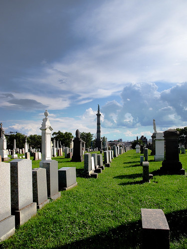
Addled as we are by the manipulations of the political class during the 20th century, with its “ism’s” and “movements“, Newtownicans have lost sight of the fact that the Newtown Creek was the center of the world for those who dwelt here in the 19th century. Before the American Civil War, the banks of the Newtown Creek were lined with homes built to the highest aesthetic standard, and peppered with grand hotels which catered to the sportsman and recreational fisherman. It was into this pastoral wildrness that the Calvary Cemetery was embedded in 1848, and which it sought to blend into with its fine arboreal stock and tasteful mastery of the art of landscaping.
It seems odd to us- sitting in our comfortable climate controlled and fully electrified homes and offices, to put a cemetery like this- with its ornate stonework and elaborate masonry, so close to the polluted industrial zones of the nearby Newtown Creek. Calvary spreads atavistically across a deserted and blasted landscape in our 21st century, surrounded by the trampled nest and discarded remnants of the industrial revolution.

– photo by Mitch Waxman
My long walks around the Newtown Pentacle have often carried me through this curious place. A saturnine break from the monotony of gated industrial sites and their rusted wonders, the art of Calvary’s groundskeepers and architects is sublime to behold.
Fashionable to their particular time period and era, the wholesome multitudes of gravestones congregated here represent a century of New York’s aspirations. The early stones are humble in aspect, their faces displaying eroded and flaking cursive typography, and use a variegated stock of geologic sources for their composition- some are simple concrete. Their legends mention familial relations, and often the name of the bereaved or society which erected the monument to the fallen is included as a postscript.

– photo by Mitch Waxman
As the years progress, marble standardizes and Calvary’s hillocks gain an elaborate posture. The sculptural shaping and calligraphic quality of these stones is remarkable. Designed in a manner reminiscent of the early days of newspaper advertising, the creeds these reconstruction era markers bear boast of affiliations with immigrant societies– often mentioning their old address in Europe (County Cork, Sicily, etc.). The glittering polish of the approaching 20th century is accompanied by the appearance of a sort of resume on the stones, discussing achievements of the deceased in the newly quantized “professions” of law, or business, or medicine. 20th century mass production dominates near the edges of the property, and the familiar block printing and glittering finishes of a modern graveyard appear on the tomb markers.
– photo by Mitch Waxman
As had been the case with the dynamic weather of the summer of 2009, in which New York was under the daily threat of violent thunderstorms, the sky was growing dark. In the distance, thunder rumbled loudly enough that I heard it through my ever present headphones and managed to somehow overpower the driving beat of the Mountain Goats song I was playing at the time. While taking this photo, I almost stumbled into a sinkhole- undoubtedly produced by the recent wet weather, nearly twenty inches across. Looking into the hole (sorry, my flash just couldn’t do the job) I could not see its bottom. Molehills, I thought.

– photo by Mitch Waxman
I am, as I’ve mentioned in previous posts, an inferior specimen and great physical coward- prone to metabolic manifestations of my inner timidity. Shaken by the ramifications of what would have happened if I’d stepped directly into that chasm, I instinctively started moving toward the safety of pavement. In this moment of self loathing and personal recrimination, I wandered past the Soldiers memorial, where the 21 noble dead have rested in centuried oblivion since 1866.
from nycgovparks.org
This park, in a triangle formed by First Calvary, Green Avenue, and Gale Street within Calvary Cemetery, has roots in the history of the Roman Catholic Church in Manhattan. In 1817, the Trustees of St. Patrick’s Cathedral (now called Old St. Patrick’s Cathedral) on Mott Street realized that their original cemetery on Mulberry Street was almost full. They drew up a charter for a burial ground in Queens, and on October 29, 1845, the Trustees bought 71 acres of land from John McMenoy and John McNolte. They named the cemetery after Mount Calvary, where Jesus Christ was crucified according to the New Testament. The first burial in Calvary Cemetery took place on July 31, 1848. Since then, the Roman Catholic cemetery, which now comprises Old Calvary Cemetery and New Calvary Cemetery, has expanded to 365 acres, and is the largest cemetery in the United States.
On April 28, 1863, the City of New York purchased the land for this park from the Trustees of St. Patrick’s Cathedral and granted Parks jurisdiction over it. The land transaction charter stated that Parks would use the land as a burial ground for soldiers who fought for the Union during the Civil War (1861-65) and died in New York hospitals. Parks is responsible for the maintenance of the Civil War monument, the statuary, and the surrounding vegetation. Twenty-one Roman Catholic Civil War Union soldiers are buried here. The last burial took place in 1909.
This park is one of many public parks that serve as burial grounds. There are burial sites in Fort Greene Park (the Prison Ship Martyrs’ Monument) and Prospect Park, in Brooklyn, and in Drake Park, Pelham Bay Park, and Van Cortlandt Park, in the Bronx. Other parks throughout the city were once potter’s fields which had no grave markers. Washington Square, Union Square, Madison Square, and James J. Walker Parks in Manhattan and Wayanda Park in Queens were all cemeteries for paupers and drifters.
The monument features bronze sculptures by Daniel Draddy, fabricated by Maurice J. Power, and was dedicated in 1866. Mayor John T. Hoffman (1866-68) and the Board of Aldermen donated it to the City of New York. The 50-foot granite obelisk, which stands on a 40 x 40 foot plot, originally had a cannon at each corner, and a bronze eagle once perched on a granite pedestal at each corner of the plot. The column is surmounted by a bronze figure representing peace. Four life-size figures of Civil War soldiers stand on the pedestals. In 1929, for $13,950, the monument was given a new fence, and its bronze and granite details replaced or restored. The granite column is decorated with bronze garlands and ornamental flags.

– photo by Mitch Waxman
Daniel Draddy was an irish speaker from County Cork, and the son of John Draddy- a stonecarver and prolific author in the Irish language who hailed from a family on Quaker Road. In context, they came from what modernity would describe as “an oppressed religious underclass involved in an ethnic and cultural war with an aggressive and powerful neighbor willing and and able to actively engage in state sponsored genocide and ethnic cleansing“ but which they would have called the Irish Potato Famine.
Daniel maintained his marble studios on 23rd street in Manhattan, near the east river. Known as a cultured and gracious host, he was beloved by the Tammany men. Contemporaries describe him as a first class carver, mechanic, historian, and he had the ability to write in the Irish language “druidically”.
Resemblance of the monuments to the tombs of ancient Egypt is no accident. The men who built this were Free and Accepted Masons.
This is masonic iconography, with its obelisk splitting the solar wisdom into the four cardinal directions and the four deities of the spaces found between standing watch at intersecting 45 degree vectors. Such falderol was quite in vogue after the Civil War, look at the Capitol Dome or Supreme Court building in Washington D.C. for similar thematic elements.
Don’t forget- Draddy was a stonecutter, from a family of stonecutters. That made him a Free and Accepted Mason, who’s existential threat was the subject of much Catholic liturgy. The Masons, especially after their successes in the Lowlands and North America in the 17th and 18th centuries, were considered a dangerous fifth column in the power structure of Europe. In the United States, the origins of the mythology surrounding them was beginning to form. In the 19th century men like Draddy would have been considered as subscribing to an “ism”, and its odd to find such iconography in a Catholic cemetery. The Church bore a special antipathy toward the Masons in this period of time, and even today they officially shun members.

– photo by Mitch Waxman
As with all designs that use esoteric 19th century schoolboy philosophies as their jumping off point, one must consider the numerical and iconic minutiae of the structure. The 40×40 yard plot- the 50 foot obelisk- these numbers and their factored multiplexes represent a hidden numerical code that initiates would find significant. Often, these numbers will refer back to a holy book or a date assigned to the matyrdom of a saint. Have no doubt that this was thought out and discussed by the designers and builders.
This is another difference between the generations that lie embraced in the earth here- and ourselves- what they built was often shaped by symbolism, we build for utilitarian usage.
They had magick as a part of their lives, whether it took the form of spiritualism, adherence to superstitious custom, or the mad passion of 19th century mass religion. In the 21st century- all we’re meant to have is a sense of hard reality, and our sacred sphere is a profanity, an understudy wearing the costume of a Maestro.

– photo by Mitch Waxman
The power of religion in the 19th century (and to a certain extent 20th, but not after the great depression) foment of immigrant New York City is impossible for us to conceive of today. The churches were part of “the system”. When you got off the boat and arrived in Manhattan, the first place you headed to was the congregation established by people from your region of origin. There, you would be inculcated into surviving the stinging whips of unregulated predatory capitalism which America (Chicago, and especially Manhattan) had so recently innovated. Many of these people had been recruited by agents of factory owners who traveled the back roads of Europe, whose pitch was the original “streets are paved with gold” story. Trapped by circumstance and poverty, the only break allowed by the bosses from the satanic schedules of mill work common to this period- called the industrial revolution- was obeyance to god. And the only place for “the deserving poor” to be buried for free- when this world eventually killed them, was in Calvary at the discretion of their local priest.
The priests of the time were not the isolated and dry cleaned empty cassocks seen scurrying around modern temples, shuttling into late model cars and thinking of their devotions as a career choice. These were brawlers from the working class, iron men (and women, of course) who had experienced the worst that this hostile environment could offer. When they talked, gangsters and cops listened. The churches one can find here in the Newtown Pentacle (Greenpoint especially) speak of the size and devotion of their congregations to the cause. Population numbers from the time are inaccurate at best, but there were a lot more people living in the very same rooms that we moderns now occupy. It was common to have 8-10 people living together in a what was called 1 bedroom tenement flat back then, but which is now a condo.
These were priests who could inspire men to build a Calvary Cemetery.

– photo by Mitch Waxman
These priests, the sort who produced Babe Ruth and Al Capone, could inspire men like the Johnston Brothers of Manhattan to build this mausoleum. In its decrepid state, colored by automobile exhaust and its delicate stained glass twisted and torn, only hints at its former glories can be discerned.
The Johnston Brothers were the proprietors of the J. & C. Johnston company, located ultimately at the corner of Broadway and 22nd street in Manhattan. They sold lady’s novelties, ribbons, parasols and other fripperies from their prestigious “ladies mile” location. Lady’s Mile was anchored on the busy industrial side by Union Square and Tammany Hall, and on the swank side by 23rd street with its new “department stores”. Theodore Roosevelt was born in the family home a few blocks away, and the prestigious townhouses that still line the surrounding area speak to the former exclusivity of the neighborhood.
There were three brothers- John, Robert, and Charles. Charles died in 1864, John in 1887 (possibly of a suicide). Robert, reknowned as an unlettered yet expert scholar in the fields of literature, mathematics and history, was so consumed by grief and longing for his siblings that he lost the family business in 1888, and then retired to a country house at Mount St. Vincent on the Hudson (near a convent). During a later foreclosure on his property- which he had financially mismanaged due to his grief, a fire broke out and nearly claimed Roberts life. In the end, he was found dying of pnemonia and suffering from madness by groundskeepers in a barn on the property.
Once more, a member of our Flickr group, sorabji, is the acknowledged Pentacle authority on this place. Check it out.

– photo by Mitch Waxman
Like other industrialists, the Johnstons often reached out to their contacts in their country of origin to recruit trustworthy laborers. Robert’s name appears as principal donor to the The Fermangh Relief society, offering to aid those deserving persons in destitute circumstance with the costs of emigration and freedom from the terror of landlords. The Johnstons were also Tammany men.
Like a stalking horse, magickal themes and ideas which were common notions at the time- like our “keeping it real” or “karma” memes are today- emerge. This kind of wholescale rending of the substance of your life was considered an appropriate response to death by the culture back then. When my grandfather died, my dad ripped his shirt in half- symbolically. When my dad died, I kissed him on the head. Think of all those old ladies in Brooklyn who have been wearing black for 40 years- they’re the last vestige of this supernatural cultural worldview that was so brutally crushed by “the -ism’s” in the 20th century. What would be considered a psychotic breakdown by our empiricist eyes- a medical event which could be managed and nursed delicately back to health- the Newtownicans of the late 19th and early 20th century saw as a metaphysical consequence of guilt and punishment. But- life in their time was not as it is now, despite superficial commonalities and vestigial building stock- these people were ruled by deep passions and motivations that modern cultures negate and control with psychoanalytic insight.
I won’t dare to question grave rituals, which I define as “deep down monkey stuff”. Like Patti Smith, I believe everything and everyplace is holy, especially the place between my ears- but that’s me- I’m all effed up- I hang around in graveyards, after all. I think elaborate sites like Calvary are very good news for 22nd century archaeologists, though.

– photo by Mitch Waxman
First, there was no electricity. Water came into the house in buckets carried up dark stairwells into smoky crowded rooms lit by candle. A single stove cooked whatever poor food was available, and provided meager heating. You defecated in a bucket and left the nightsoil in the alley for collection, or you just poured it out a window. Coal was expensive, its price controlled by mobsters and railroad chiefs, so you wore multiple layers of clothing all the time. Children slept in doorways and under wagons, their parents unknown. Work was hard to get, controlled by the Tammany men. Fraternal societies and lodges offered political affiliations and entry to the workforce.
The collected night soil was shipped to Newtown Creek’s offal docks. One of our first posts was on this topic, click here for “the Night soil and offal docks, and Jell-O“.
Ethnicity was what mattered to the politicians, who would lure their kin into great concentrations in certain districts to solidify their power. Other Tammany men would open factories and mills in these wards, employing the entire community as in the manner of a sharecropper and his serfs. These were the early stages of the process that gave New York’s neighborhoods their ethnic character, and which has evolved considerably since. Men didn’t drink back then, they just got drunk.
The most conspicuous modern examples of this “ethnic character” (which are stereotypes, I know, but are commonly referred to and repeated by area residents) would be Greek Astoria, Irish Woodside, Mexican Corona, Desi Jackson Heights, Russian Brighton Beach, and East Asian Flushing- but the circumstance and stories of these communities are considerably less brutal than the experiences of Irish, Italian, Pole, German, Negro, and Jewish Newtownicans in the 19th century.

– photo by Mitch Waxman
The first of the “ism’s” was progressivism, which believed that “the system” was broken as it was, but could be fine tuned via a more equanimously slanted division of the profits derived by labor. By enacting standards for industry to follow, and rules for worker safety and compensation, as well as the right to bargain collectively with the industrialists as part of a trade union, this fine balance could be found.
The progressives won many victories which are part of the american worker’s birthright today – adoption of the English or 8 hour day, meal breaks, coffee and bathroom breaks, medical insurance for injuries on the job, unemployment insurance, and they put child labor to an end. The people buried here are the battle hardened combatants, both bosses and workers, of a dynamic period in American politics that set the stage for a military and political collossus to emerge in the mid 20th century.
Simplistic modern jargon for this sort of political philosophy is “socialism”, which is a term which would have a great future in the 20th century.

– photo by Mitch Waxman
Still shaken by my near misstep into the sinkhole, I took to the paved road and was gratified to see St. Rafael’s loom large in an innocuously clear blue sky. However, the sounds of thunder, and an ever present and growing breeze were coming from the northwest. My attentions were drawn to the direction of the open ocean, where the storm was approaching from. I wondered, had I looked too closely at this place and stayed too long?
I headed for the Greenpoint avenue gates with all haste, knowing that I had a maximum of 30 minutes before I would be forced to find shelter in this verdant graveyard against the approaching storm. As I was the only person visible at the time in all of Calvary, and possessed of unnaturally bad luck- I figured lightning would hit me- so I quickened my pace to a dog trot and headed for the streets of Queens.

– photo by Mitch Waxman
As I hurried along my way through the enormity of Calvary, my mind was racing with endless speculations about the place, and all the crazy yarns and apocryphal stories I’ve been told about it.
Just so there’s no mistake- these are STORIES I’VE BEEN TOLD AND THINGS I’VE OBSERVED, NOT FACTS.
What happened here in the early 70’s, when cults and secret magickal societies conducted hippie rituals here? What about that grave robbing story dating from the crack years I heard from a drunken ex cop? How many low level mobsters have mentioned this place as being a convenient hiding place for contraband? What about the demon haunted catacombs below, where the church buries its priests?? What are those weird metal hinged hatches with the steel staircases leading down from ground level on the BQE side? Where do they go? Where is the sewer outfall from the extensive drainage system installed on these tumulous hills? Who lives downstream from the largest graveyard in the United States? Does Calvary pay taxes? What about the “shape” my neighbor described as “moving amongst the trees in a way that just wasn’t right” while riding his bicycle home from a job along Review Avenue one January night?

– photo by Mitch Waxman
In the distance, the storm had reached Manhattan, by all appearances. Luckily, a short walk returned me to the streets of 21st century Queens, where I hailed a livery cab and returned to my rooms in Astoria. In accordance with the traditions of my fathers- I washed my hands and took my shoes off before I entered the house. A little sympathetic magick never hurt anyone, I always say… and besides- this place is a block from the apocalyptic landscape of the Newtown Creek. God only knows what I walked through.
Anything you may experience, in situ, by following these walking directions is at your OWN RISK, and is offered by the Newtown Pentacle for documentary and entertainment purposes only. Remember- the rule we follow at the Newtown Pentacle is to NEVER trespass. Like Vampires, Newtownicans should wait to be invited into a house before they can do their work. Also, Please note — if something you read here is inaccurate, DO NOT BE SHY- contact me– additions and corrections are always welcome at the Newtown Pentacle.
Calvary Cemetery walk
feel like taking a walk? I’ll show you something cool… Bring your camera- and ID
Here’s a google map.
For a larger contextual view of Calvary Cemetery- check out our previous posts-
Walking Widdershins to Calvary
This post also intersects with
Dead Ends, A short walk from Maspeth to Calvary

-photo by Mitch Waxman
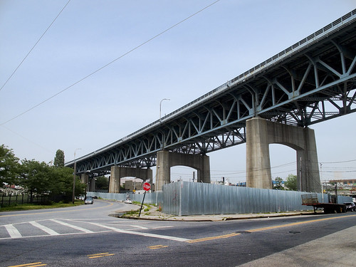
Just across the street from the site of the former LIRR Penny Bridge station. Easily accessed via the street, upon crossing the gates of Calvary, one will find a staircase carven into the hill by whose ascent the Newtown acropolis may be obtained. Cresting over the surrounding neighborhoods, and soaring over the Newtown Creek’s former wetlands, Calvary Cemetery keeps its secrets buried in centuried silence. Looking south toward Brooklyn, the Kosciuszko bridge approach of the Brooklyn Queens Expressway looms over its passage, carrying millions of vehicles over and across the necropolis of New York City.

-photo by Mitch Waxman
Phantoms of what could have been haunt Calvary, roaming in soliloquy amongst the avenues of nitre dripping marble. The 1918 superflu and an earlier cholera epidemic staffed the ranks here with both the sacred and the profane. St. Patrick’s in Manhattan used this place for the interment of New York’s best and brightest. This is where the ossified remnants of the men who died battling the traitorous slavers of the Confederate South can be found in the Newtown mud. In subterranean vaults of marble and basalt, and within leaden coffins, these gentlemen– the ultimate product of an age of victorian aspirations- lie in putrid splendor, alongside the occasional merchant and immigrant whose life savings were traded to purchase their final resting place.

-photo by Mitch Waxman
A member of our flickr group, sorabji, has written an excellent description- in some great detail on the Civil War monument and the Johnston mausoleum. Which you’ll find in concrete reality when you gaze from the summit of the great hill. I won’t attempt to better sorabji’s efforts, and will simply ask you to follow the link and check out the research.
At the apex of the hill, which is the acropolis of Calvary on the Newtown Creek side, there can be found a tree.

-photo by Mitch Waxman
Undoubtedly centenarian at the very least, the bark and leaves of this tree are of an unnaturally dark and forbidding aspect. Its branches sway in patterns that have nothing in common with the prevailing winds. Its trunk is observed wearing a a sickly blanket of moss. Vigorous and quite healthy despite its proximity to the poisons of the Newtown Creek, the tree is obviously nourished by some sort of morbid nutrition.

-photo by Mitch Waxman
An apocryphal story passed down by Brooklyn folks is that of the door to door salesman seeking to sell you a funeral plot “on a hill, under a shady tree, near a babbling brook”. The proper Brooklyn response is- ‘yeah? and I gots a bridge to sell youse”.
This, my friends, is the very archetype of that con job. The hill is called Laurel and the babbling brook is, and was, the Newtown Creek and the grave is in Calvary.

-photo by Mitch Waxman
How deep do the roots of this tree plunge into the tumulous earth? And where can they lead? What foul corruptions do they feed upon?

-photo by Mitch Waxman
Can it be, that just like every other place in New York’s megalopolis, Calvary’s “holy ground” is actually the roof of some cyclopean structure?
Anything you may experience, in situ, by following these walking directions is at your OWN RISK, and is offered by the Newtown Pentacle for documentary and entertainment purposes only. Remember- the rule we follow at the Newtown Pentacle is to NEVER trespass. Like Vampires, Newtownicans should wait to be invited into a house before they can do their work. Also, Please note — if something you read here is inaccurate, DO NOT BE SHY- contact me– additions and corrections are always welcome at the Newtown Pentacle.
Walking widdershins to Calvary
feel like taking a walk? I’ll show you something cool… Bring your camera- and ID
Anything you may experience, in situ, by following these walking directions is at your OWN RISK, and is offered by the Newtown Pentacle for documentary and entertainment purposes only. Remember- the rule we follow at the Newtown Pentacle is to NEVER trespass. Like Vampires, Newtownicans should wait to be invited into a house before they can do their work. Also, Please note — if something you read here is inaccurate, DO NOT BE SHY- contact me– additions and corrections are always welcome at the Newtown Pentacle.
Over Hill and Dale part 3- Widdershins around Calvary

-photo by Mitch Waxman
Click here to preview this photowalk in a google map
Hunters Point avenue intersects with the ancient course of Greenpoint Avenue at the degenerate extant of Long Island City. The Queens Midtown Expressway also comes back down to earth here, feeding Manhattan vehicular traffic to all points east. This is a very busy intersection, so be mindful of traffic, as fellow pedestrians are rare.
As with anyplace else in Queens you’d want to see, Forgotten-NY has been through here before. Click here for their page on Blissville and Laurel Hill.

-photo by Mitch Waxman
St. Raphael’s R.C. Church is on Greenpoint Avenue in a neighborhood called (atavistically) Blissville. A wooden frame building was built for St. Raphael’s in 1867, and served as the mortuary chapel for the newly built Calvary Cemetery. The current gothic influenced structure was completed in 1885, and has served both Calvary and the surrounding community since. This is one of the highest points in these parts, and the church steeple often acts as a reference point when negotiating the byzantine tangle of streets around the Newtown Creek. The architect is rumored to have been Patrick Keeley.

-photo by Mitch Waxman
Walk past a gas station (last chance for water or gum) on your right, and you’ll be at the corner of Greenpoint and the Queens Midtown Expressway. To your right is Manhattan, and the elevated phase of the Queens Midtown Expressway which carries vehicular traffic over Long Island City and the Dutch Kill. That’s Borden Avenue down there, under the elevated highway. Don’t worry, I’m taking you there in a few weeks. Today, we walk widdershins around the dead.

-photo by Mitch Waxman
Dead is what you’ll be if you don’t pay attention when crossing this street. Luckily, where we’re heading- you’ll fit right in. This may be a good time to remind you of a Newtown Pentacle posting from a few weeks back- “The Cemetery Belt“.
Quoting from James Riker Jr.’s “Annals of Newtown” – from Brooklyn Genealogy
CALVARY CEMETERY. This cemetery, which is located at Laurel Hill, was set apart and consecrated in 1848. It is one of the most accessible rural cemeteries near New York, and it would be difficult to select a lovelier or fitter spot as a place of sepulture. The old ground comprised one hundred and ten acres, but in 1853 a charter was obtained from the State by the trustees of St. Patrick’s cathedral, New York city, for 250 acres; 165 acres of this are now enclosed. The artesian well in that part of the enclosure called New Calvary was sunk in 1879. It is 606 feet deep and 6 3/4 inches in diameter, and was bored in white granite for a large part of its depth. Last year 32,000 persons died in the city of New York, and of this number 15,500 were buried in Calvary. The cemetery keeps one hundred and fifty men regularly employed, and two hundred more are kept at work by the relatives and friends of the deceased. Here may be found some of the choicest of materials and the finest models in monumental structure; and here we may mention as worthy of note the vault and chapel built by John Johnston, at a cost of $75,000, and regarded as one of the finest to be found in any ground. This cemetery is to the Catholics of New York what Greenwood is to the Protestant population. Since 1872 Hugh Moore has been the general superintendent, and to his ability much of the beauty and attractiveness of the place is due; he has been assisted by Michael Rowen. The mortuary chapel, of fine architectural design and finish, was built in 1856. The present chaplain is Rev. M.J. Brennan.

-photo by Mitch Waxman
The shadowed lanes of Calvary await your hungry eyes, but we are not entering the necropolis today, dear reader. Instead, we’re lurking around its nitre dripping fenceline, scuttling along the broken pavement and visible cobblestones of Greenpoint Avenue to the corner of Bradley Avenue, where we will turn widdershins (left).

-photo by Mitch Waxman
Click here for a Wikipedia page on Calvary Cemetery, to familiarize yourself with the story of this extraordinary place and the people who chose this as their final address.
To the modern mind, the Greenpoint Ave. gates of Calvary are the obvious main entrance to the place due to their proximity to the highway- but the actual street address of Cavalry is at 49-02 Laurel Hill Blvd.- which is on the Newtown Creek side (we’re going there, don’t worry). When this place was built, the Newtown Creek was the central artery of the surrounding communities, not the barrier that modernity has made of it.
Often, as I am out exploring these areas (in the early 21st century), I’m asked by neighborhood people- members of a long abused community which is wary of strangers – what I’m up to. I’ll explain my interest in the area and then be asked “What’s Newtown Creek?” by people who live in Greenpoint or Long Island City. Manhattan people think you’re just making it all up- they say “how can that be? You’re exaggerating” when you tell them about this place.
If members of “the community” aren’t even aware that the Creek exists, how can we ever hope to coerce our political class to address its many problems? Please, bring your cameras down here and peek under a few rocks yourself. Tell the story of this place.

-photo by Mitch Waxman
Bradley Avenue is truncated by the iron fencelines of Calvary, and we’re going to follow the dead end here, onto 37th street. I often wonder, when the fences of Cavalry are closed, what sort of things transpire in this lonely place.

-photo by Mitch Waxman
As we proceed down 37th street, the street elevation begins to drop down toward the Newtown Creek shorelines, but Calvary remains at the same grade level as Greenpoint avenue.

-photo by Mitch Waxman
A lonely industrial block, 37th street also hosts several homes of taste and substance near its intersection with Review Avenue. We turn widdershins again, to the left on Review.
-photo by Mitch Waxman
At the corner of Review, looking to your right, is the Greenpoint Avenue Bridge. Greenpoint people will find this a pleasant crossing over the Newtown Creek and a reference point for negotiating this lonely part of Long Island City.
-photo by Mitch Waxman
On Review Avenue, the wall of Cavalry looms. That’s the Kosciuszko bridge in the background. The cyclopean scale of Cavalry is apparent here, and behind that masonry lie the dead.

-photo by Mitch Waxman
As you continue down Review Avenue, you’ll be passing the old LIRR Penny Bridge station at the corner of Review and Laurel hill Blvd.

-photo by Mitch Waxman
Now dear readers, this is your first revelation of a master plan behind the Newtown Pentacle. I am willing to reveal that everything is connected. This corner is where the post “Dead Ends, A short walk from Maspeth to Calvary” ends. That post picked up where “the Wrong side of the tracks, a walk in Maspeth” ended. Turn Widdershins on Laurel Hill Blvd.
-photo by Mitch Waxman
The big problem you’ll have, however, is that there isn’t really a functional sidewalk here on Laurel Hill Blvd. I’m quite used to this sort of thing at this point, so…

-photo by mitch Waxman
Commanding views of Calvary can be had here. The elevation rises, and St. Raphael’s comes into view.

-photo by Mitch Waxman
As you proceed, on the other side of the BQE will be a heavy manufacturing zone with relict housing interspersed. The area has an aura of long time municipal neglect.

-photo by Mitch Waxman
At the end of Laurel Hill Blvd, you will find a pedestrian bridge which is covered in a tightly woven chain link fence. Except for this spot, at tripod height, that was cut by some photographer in the past. The same person (same cut pattern and size) was also nice enough to cut a hole in the fence on the Pulaski Bridge.
Dead Ends, A short walk from Maspeth to Calvary
Feel like taking a walk? I’ll show you something cool… Bring your camera- and ID
Anything you may experience, in situ, by following these walking directions is at your OWN RISK, and is offered by the Newtown Pentacle for documentary and entertainment purposes only. Remember- the rule we follow at the Newtown Pentacle is to NEVER trespass. Like Vampires, Newtownicans should wait to be invited into a house before they can do their work. Also, Please note — if something you read here is inaccurate, DO NOT BE SHY- contact me– additions and corrections are always welcome at the Newtown Pentacle.
Over Hill and Dale part 2- Newtown Creek to Calvary
So, last time, I left you on the wrong side of the tracks in Maspeth. Sorry, it can be a very nice place, and there is extremely good italian food for sale in the residential parts of Maspeth that shouldn’t be missed.
However, we are on the industrial side of town- down by the Newtown Creek- where the sins of our fathers continue to haunt modernity.
This is where we left off on July 16th- at the corner of 56th road, between 48th and 50th streets in Queens. This is an insanely dangerous patch of road running through a literal industrial backwater, so be careful. Last time we walked down the Maspeth Plank Road toward Brooklyn, today we’re going another way- tracing the course of the Newtown Creek on the Queens side for a while.

-photo by Mitch Waxman
From the vantage point above, look to your right, and you’ll see the Kosciuszko bridge. Head in that direction, which is roughly northwest and toward Manhattan. You’ll be walking down 56th rd. for a little while. The sidewalk on the Creek side is fairly non-existent, so cross the street. Watch out for trucks. Why was I here on foot, you ask?
Check out a google map of this post here. The previous Maspeth walk map can be found here.

-photo by Mitch Waxman
This walk is one that would be quite familiar to anyone living in the last century. If one was visiting a grave at Calvary, from the Brooklyn side, you’d cross Penny Bridge or the Maspeth Avenue Plank Road and head to Laurel Hill. This is a heavily industrialized section of the Newtown Creek, one which has fallen into a sort of holding pattern over the last couple of decades. Once upon a time there was a copper refinery here, one that was owned by a company called Phelps Dodge.


-photos by Mitch Waxman
At 43rd street, look to your left and see a railroad track, and the crossing over to 57th avenue. That’s Restaurant Depot on the left, the Newtown Creek is dead ahead. That’s Brooklyn on the horizon.

-photo by Mitch Waxman
from queenslibrary.org
A history of the Laurel Hill Chemical works from the beginning in 1852, from the Phelps Dodge Corporation Laurel Hill Plant Records, 1893-1983.
The following is a chronology of Phelps Dodge Corporation’s Laurel Hill Plant starting with William Henry Nichols, the man who co-founded the original chemical plant, G.H. Nichols and Company at the site in 1872; continuing to when it was purchased by Phelps Dodge Corporation in 1930; and ending in 2000 when all the structures were finally demolished.
Chronology
1852
William Henry Nichols was born to George Henry and Sara Elizabeth (Harris) Nichols in Brooklyn, New York, January 9, 1852.
1870
William Henry Nichols and his friend Charles W. Walter started making acids.
1872
To expand their acid production to sulfphurc acid and support their entrepreneurial needs William H. Nichols and Charles W. Walter, with the financial backing of William’s father George Henry Nichols, formed the G. H. Nichols and Company. The new company so named, because not only did George Henry provide the majority of the capital, but also the two men were too young to incorporate a company in New York State. During the year the company began purchasing land and building buildings in the Laurel Hill (now Maspeth) neighborhood of Queens, New York on Newtown Creek. Not only did the site offer good fishing, it afforded convenient water and rail transportation to move their raw and finished material.
1870s-1880s
Their sulphuric acid, produced from brimstone, was stronger than the industry standard upsetting their competition but greatly increasing their market share.
1880s
The company and adjoining landowner Samuel Schifflin purchased and filled in a portion of Newtown Creek.
1880s early
The company developed and installed a special burner at the plant to produce sulfuric acid from pyrites, a cheaper raw material with a stable price. They purchased a Canadian pyrite mine to ensure a steady supply of the raw material. The by-product from this process is copper matte which they sold.
1880
During this year the company built and renovated a number of buildings on the grounds including: two shops on the south side of the South Side Rail Road tracks (now owned by the Long Island Rail Road); a building built by Samuel Berg Strasser and his employees; and large additions to buildings on both sides of the railroad tracks.
1881
The company continued to enlarge and improve their plant and docks and lighters were used to ship their acids on Newtown Creek.
1884
The company purchased four acres from the Rapleye Estate on Washington Avenue (now 43rd Street) and surveyed the land for a machinery and acid manufacturing building. Construction began on the new building that extends the entire block on Washington Avenue to the railroad.
1880’s mid
A confluence of two issues, their copper matte stopped selling and the copper refinery industry’s need for a proper method for analyzing the metallurgy of copper, propelled the company to discover a new process to refine copper called the electrolytic method. This process was a commercial success producing almost 100% pure copper which they named, the famous brand, N.L.S. (Nichols Lake Substitute) Copper.
1890
This year the company built two new acid manufacturing buildings, the first of this kind in the world.
1891
William Henry Nichols renamed the company from G.H. Nichols and Company to Nichols Chemical Company. The new company was incorporated the week of January 8, to manufacture sulphuric, muriatic, nitric, and acetic acid, other chemicals, and by-products. A new four story 200 foot by 120 foot building was built on Newtown Creek.
1895
The first contract was signed by Phelps Dodge Corporation and the Nichols Copper Company to have Phelps Dodge deliver a minimum of 1,000,000 pounds of blister copper over three years. This began an economically symbiotic relationship that lasted until 1922, in which Phelps Dodge provided 90% of the blister copper Nichols Copper Company used to produce almost 100% pure copper.
1899
The first important merger of chemical companies in the United States occurred when twelve companies with nineteen plants merged to create the General Chemical Company with William Henry Nichols as chairman. The Nichols Chemical Company sold its Laurel Hill Plant and land to General Chemical for $250,000. This same year plans were filed for the erection of their, 315 feet high and 36 feet in diameter, steel chimney.
1901
On the plant grounds, General Chemical erected the tallest chimney in the United States to blow the smoke and gases from its furnace away from the neighborhood. For the past number of years neighbor surrounding the plant complained vociferously about the pollution from the factory. Only after a study found that nitric, muriatic, and sulphuric acids from the plant were destroying local cemeteries’ tombstones did the company try and alleviate the problem by building the chimney. This same year the company filed plans with the New York City’s Department of Buildings in Queens to build another 150 foot chimney, an ore breaker, a storage tank, a boiler house, and a stable.
1903
A fire, started in a building used to manufacture sulphite of copper, destroys this building and two others causing $250,000 worth of damage, to this date it was the most costly fire in Newtown.
1904
For $42,500 the company purchased from Alice H. Stebbins a major tract of land whose border was 200 feet on Locust Avenue (now 44th Street), 725 feet on River Avenue (47th Street if it extended to Newtown Creek), 825 feet on Clinton Avenue (now 56th Road), and 195 feet on Newtown Creek. That same year for $25,000 they purchased another tract from Alice H. Stebbins, Mary S. Dodge, Mary J. and William J. Schiefflin, and Eleanor J. Taft whose border was 828 feet on Clifton Avenue (46th Street if it extended to Newtown Creek), 200 feet on South Avenue (a street that was on the south side of the South Side Rail Road tracks), 755 feet on River Avenue (47th Street if it extended to Newtown Creek) and 195 feet on Newtown Creek.
1912
Another major fire occurred at the plant causing $100,000 worth of damage to a building 200 feet along Washington Avenue (now 43rd Street) and 200 feet along the Long Island Rail Road tracks.
1913
During this year the landscape of the neighborhood changed considerably with the removal of the streets, Washington, Clay, Hamilton, Fulton, Clifton, and River Avenues, on plant property between the railroad tracks and Newtown Creek. Also the railroad tracks were elevated and the remaining part of Washington Avenue was made a private road. This same year the company stated that they will be increasing their workforce from 1200 to 5000 people.
1914
The plant received 150,000 tons of copper ore.
1916
The company received approval from the New York City Board of Estimates to build a boardwalk on the stretch of land on the north side of the railroad tracks, nicknamed “Death Avenue” for the many pedestrian fatalities involving trains.
1919
The company employees 1,750 people. Along with other companies along the creek they petition the city to close the streets that were not officially opened between the railroad tracks and Newtown Creek. The petition was denied by the city and the borough because it would eliminate miles of streets and cut off public access to the waterfront.
1920
Property is expanded when the company filled in some of Newtown Creek. That same year the company was expected to be tried for illegally building a freight shed on a portion of Creek Street (57th Avenue if it extended into the plant).
1920s
In exchange for stock in the company Phelps Dodge invested $3.5 million in Nichols Copper Company’s plant modernization projects. This increased the production of copper dramatically at the plant.
1930
Dr. William Henry Nichols died. This same year, Phelps Dodge bought the Laurel Hill Plant.
1940
The following products were produced at the plant: copper, silver, gold, copper and nickel sulphates, and small amounts of selenium, tellurium, platinum, and palladium. This same year more of Newtown Creek was filled in giving the plant its final size of 35.60 acres.
1940’s
During this decade the plant began importing blister copper from Africa, South America, and scrap copper from other cities, after Phelps Dodge built a refinery in El Paso, Texas.
1956
The company constructed additions to the plant’s electrolytic tank house to increase there capacity to 35,000 tons of refined copper per month. They also increased the production of wire bars. In 1956, the plant was comprised “of a custom smelter, copper refining, and copper sulphate plant. The smelter produces blister copper from the treatment of ores, concentrates, and various kinds of scrap and copper bearing materials. The refinery treats the blister copper produced by the Laurel Hill Smelter, blister and anode copper received from others on custom basis, and high grade scrap copper. Several types of copper sulphate are produced and some refined nickel sulphate.” The plant experiences an unauthorized employee strike from January 10 – February 12.
1963
The customer smelter at the plant is permanently closed in August 1963, because the limited availability of scrap copper and other raw materials and “declining treatment toll margins among custom smelters” made the smelter unprofitable. People were laid off, the smelter was dismantled, and the parts were sold. The El Paso Refinery was able to maintain the company’s production levels.
1965
Capacity of the multiple refining system was increased by 24,000 tons per year and a gas fired vertical melting furnace was installed.
1966
The furnace for removing insulation from copper wire was “placed in limited operation,” and a new building to house equipment for the receipt and sampling of incoming materials was completed.
1967
Installation began in December of a new anode casting furnace with a waste heat boiler and a new anode casting wheel.
1971
On November 1, 1971, the company permanently shut down part of the plant’s electrolytic tank house and ceased the treatment of #2 scrap, because the facilities were built prior to 1900 and were becoming too expensive to maintain and operate. The El Paso Refinery was able to fulfill the company’s production needs.
1984
The company closed the plant permanently in February 1984, due to high costs and changing markets. The plant’s final products, which they had been producing throughout the twentieth century, were copper, silver, gold, copper and nickel sulphates, and small amounts of selenium, tellurium, platinum, and palladium. The El Paso Refinery was expected to fulfill the company’s production needs.
1986
The company sold the land to the United States Postal Service on September 1986.
1996
The postal service sued the company because they did not sufficiently clean up the site and the court ordered Phelps Dodge Corporation to buy back the property.
2001
All the buildings were torn down.


-photo by Mitch Waxman
from habitatmap.org:
Phelps Dodge – Laurel Hill Development
Address
42-02 56th Rd., Queens, NY 11378
Categories
Health, Water and Toxics
Neighborhood
Maspeth
Keywords
Phelps Dodge, copper, refinery, Superfund, Freeport-McMoRan
Owner/Occupant
Restaurant Depot now occupies the center of the site
Phelps Dodge once operated a copper refining and chemical production facility at this location. Currently Sagres Partners (a subsidiary of Galasso Trucking) owns the center of the site and has leased the space to Restaurant Depot, Boston Coach, and Galasso Trucking. The properties leased to Boston Coach and Galasso Trucking serve as storage lots for their vehicle fleets. Restaurant Depot (a subsidiary of Jetro Holdings) is wholesale food warehouse franchise.
Phelps Dodge maintains ownership of the empty rubble strewn eastern and western sections of the site, though Sagres Partners has contracted to buy these properties at a later date. These parcels will need to be capped with clean soil and pavement before they can be developed. The fifteen foot wide strip of land that runs along the border of Newtown Creek will remain the property of Phelps Dodge indefinitely, as they are responsible for maintaining the retaining wall and groundwater pumps that prevent toxic soil and groundwater from migrating into Newtown Creek from beneath the site.
Previously barring entrance to the western third of the site, this sign has now been taken down.
According to a report by Cushman & Wakefield filed with the Securities and Exchange Commission, Sagres Partners sold three parcels of land from the former Phelps Dodge site to three separate entities in 2005. A 108,900 sq. ft. parcel was sold to Radhaswamy for $8 million, a 65,000 sq. ft. parcel was sold to Montebello Italian Food Company for $5.4 million, and a 120,000 sq. ft. parcel was sold to Thai Food Company for $9.8 million. By Summer 2008 none of these entities had developed their properties and it is not known whether they still own them.
In 2007, Phelps Dodge Refining Corporation was acquired by Freeport-McMoran Copper & Gold Inc., the world’s largest publicly traded copper company, for $26 billion. Headquartered in Phoenix, Arizona, Freeport-McMoran conducts its business through its principal operating subsidiaries: PT Freeport Indonesia, Phelps Dodge, and Atlantic Copper. Freeport McMoran principally mines copper, gold and molybdenum and they have mining operations throughout the Southwestern United States, Peru, Chile, Indonesia, and the Democratic Republic of Congo.
According to an investigative report by the New York Times Freeport-McMoRan bribed Indonesian politicians and military officers and utilized the Indonesian military to threaten, harass, and kill those in opposition to their mines and mining practices. In addition, Freeport-McMoRan has dumped millions of tons of toxic mine tailings into watersheds in Indonesia thereby polluting the environment, destroying livelihoods, and poisoning thousands of people.
Location Details
The Phelps Dodge Laurel Hill Industrial Facility circa 1933. All the buildings pictured were demolished in 2000.
After 113 years of continuous industrial copper and chemical production, the Phelps Dodge Laurel Hill Works industrial facility ceased operations in December of 1983.[1] After shutting down, the property lay vacant for several years until the US Postal Service agreed to buy it in 1987 for $14.7 million. Much to their chagrin, the Postal Service soon discovered that the property was too polluted to develop leading to a 1992 lawsuit against Phelps Dodge by the US Attorney General. The suit was settled in 1997, the terms of which required Phelps Dodge to take back the property, remit the purchase price plus interest, and enter into negotiations with the NY State Department of Environmental Conservation (DEC) to arrange a clean up of the property.
Two years later, in 1999, Phelps Dodge negotiated a Consent Decree with DEC to develop a remedial action plan for the site. In 2000 the site was razed and thousands of tons of hazardous soil and sludge (contaminated with cadmium, chromium, copper, lead, mercury, petroleum hydrocarbons, PCBs and more) were hauled away and a retaining wall and groundwater pump were installed along the creek-front to prevent toxic soil and groundwater from migrating into Newtown Creek from beneath the site. Phelps Dodge spent over $30 million cleaning up the property, an amount considered inadequate by some members of the community who wanted a complete remediation of the site at an estimated cost of over $200 million.
Looking west across the site towards the Kosciuszko Bridge
In 2004 construction began on the now completed Restaurant Depot, a 75,000 square-foot wholesale food warehouse franchise. The properties just east of Restaurant Depot are used by Boston Coach and Galasso Trucking as storage lots for their vehicle fleets.
The Phelps Dodge Laurel Hill copper smelter may now be history but its toxic legacy continues to live on in the sediments and surface waters of Newtown Creek. To date, Phelps Dodge has yet to take any responsibility for, and begin removing, the toxic waste they dumped into the Creek for over a century. In February 2007, Phelps Dodge refusal to clean up the Creek lead the Attorney General of New York, Andrew Cuomo, to announce his intention to sue them for endangering the “health and the environment in Newtown Creek and portions of the adjacent shoreline”.


-photos by Mitch Waxman
Crossing the tracks (this is a city sidewalk, 43rd street and 57th avenue), i walked back into the parking lot of Restaurant Depot (which is a “public area” on private property). This was dumb, and borderline trespassing, but I was prepared to go inside the store and buy a gross of strawberries if I had to. Just a customer, Mr. Security Guard… Hopefully- this is one of the parts of Newtown Creek known for its love of photographers and its ribald sense of humor. The hair on the back of my neck was standing up so I just kept moving, and snapped my shots as I walked. I knew a security camera or two was on me and didn’t want to wear out my welcome.


-photo by Mitch Waxman
There were rail tracks here once, on the docks. Wow. Just wow.

-photo by Mitch Waxman
I kind of figure I’m not going to be seeing the Kosciuszko bridge for much longer. Its scheduled to be replaced, so I’ve been trying to record its last seasons in some detail. This is still in the Restaurant Depot parking lot, but I’m already walking a bit faster. Hidden eyes were keenly felt- sorry security guys.

-photo by Mitch Waxman
Looking back at 57th avenue, from down under the Kosciuszko bridge (DUKBO)- I turned back onto 43rd street, and hurriedly made a left onto 56th road. Continue in the western direction toward the intersection with Laurel Hill Blvd.

-photo by Mitch Waxman
High above me, the Brooklyn Queens Expressway crosses the Kosciuszko Bridge. On the easterly side of the street is a police tow yard.
For those of you reading this from outside the City of Greater New York, this is a great example of the macabre logic that the City operates under. The one tow yard in all of Queens is at one the most inaccessible by mass transit, seldom traveled to, and hard to find spots in all of Queens.
-photo by Mitch Waxman
I consider this corner- where Laurel Hill Blvd. meets 56th rd. and Calvary Cemetery to be a Long Island City, Laurel Hill, and Maspeth bordeline locus point. I’m sure this is also my personal opinion, and that I’m probably wrong. All I can say is that it feels like a border between the neighborhoods.

-photo by Mitch Waxman
On the Newtown Creek side of Laurel Hill Blvd. are a series of heavy industry sites. One or two are available for sale or development, if you’re interested in buying 200 years of ecological damage.
-photo by Mitch Waxman
When we arrive at Laurel Hill Blvd, corner of Review- the signs are clear.

-photo by Mitch Waxman
Just look across the street, where the gates of Calvary Cemetery beckon (and which we’ll be exploring in the next installment).
Or look behind you, at the sadly neglected site of the historic LIRR Penny Bridge station.


-photo by Mitch Waxman
Nazi grafiti has appeared here just recently. This sort of ugly street iconography has been appearing all over LIC and Greenpoint lately.
Not too worried about it, as New York City has a way of squashing bugs when they scuttle across the floor. These guys are going to get caught in the act, and if they are very lucky, it’ll be by the cops.
More to come.


