Archive for the ‘Long Island Rail Road’ Category
Dutch Kills has balls
Be sure to check out the large images at flickr for insane amounts of detail in these shots.
In some places- every stitch on a baseball.

– photo by Mitch Waxman
I am given to moods, melancholy, and suffer from an abundance of hubris– due to a series of ego related karmic retributions. All ‘effed up, there are days- often sunny ones- when I wake from that dark and torturous dreamland inflicted on me since my wastrel youth– in one of my little moods.
from wikipedia:
The US National Library of Medicine notes that “some people experience a serious mood change when the seasons change. They may sleep too much, have little energy, and crave sweets and starchy foods. They may also feel depressed. Though symptoms can be severe, they usually clear up.” The condition in the summer is often referred to as Reverse Seasonal Affective Disorder, and can also include heightened anxiety.
also from wikipedia:
The name “melancholia” comes from the old medical theory of the four humours: disease or ailment being caused by an imbalance in one or other of the four basic bodily fluids, or humours. Personality types were similarly determined by the dominant humour in a particular person. Melancholia was caused by an excess of black bile; hence the name, which means ‘black bile’ (Ancient Greek μέλας, melas, “black”, + χολή, kholé, “bile”); a person whose constitution tended to have a preponderance of black bile had a melancholic disposition. See also: sanguine, phlegmatic, choleric.
Melancholia was described as a distinct disease with particular mental and physical symptoms in the fifth and fourth centuries BC. Hippocrates, in his Aphorisms, characterized all “fears and despondencies, if they last a long time” as being symptomatic of melancholia.
In the medieval Arab world, the Arab psychologist Ishaq ibn Imran (d. 908), known as “Isaac” in the West, wrote an essay entitled Maqala fi-l-Malikhuliya, in which discovered a type of melancholia: the “cerebral type” or “phrenitis”. He carried out a diagnosis on this mental disorder, describing its varied symptoms. The main clinical features he identified were sudden movement, foolish acts, fear, delusions and hallucinations.[4] In Arabic, he referred to this mood disorder as “malikhuliya”, which Constantine the African translated into Latin as “melancolia”, from which the English term “melancholia” is derived.
Ali ibn Abbas al-Majusi (d. 982) discussed mental illness in his medical encyclopedia, Kitab al-Malaki, which was translated into Latin as Liber pantegni, where he discovered and observed another type of melancholia: clinical lycanthropy, associated with certain personality disorders. He wrote the following on this particular type of melancholia: “Its victim behaves like a rooster and cries like a dog, the patient wanders among the tombs at night, his eyes are dark, his mouth is dry, the patient hardly ever recovers and the disease is hereditary.”
Nasty, and a few seconds out of synchronous function with others, I keep to myself and let hatred boil off of me in bright green sheets. For a few hours or even several sleepless days, there will be a storm in me, and in a tangential and often pedantic manner I will think aloud about existential minutiae to calm my racing thoughts…
…November 15th, 2008, in this case…

Actually Sunnyside yards, but shot on the same day as the other ones- photo by Mitch Waxman
Warm and humid patches of air had permeated the greater New York area for several days, producing the frequent rain and gray fogs which had made the Autumn of 2008 remarkable.
After a severe squall, whose high winds and driving rains obliterated those clouds occluding the Hunter’s Moon during the previous week, and an unusually warm late summer and autumn- a phenomena once referred to as “Indian Summer“- the entirety of the area found itself coated in a grimy patina of storm blown mud and filth- like the garage door which is the photographic subject above and below. There was blown grit on the sidewalk, with wind action the presumed culprit, as the storm picked its pathway through the rain puddles which collect in and garland the broken pavement of the Newtown Pentacle.
from wikipedia:
The DSM-IV-TR, a widely used manual for diagnosing mental disorders, defines Agoraphobia Without a History of Panic Disorder as:
The presence of Agoraphobia related to fear of developing panic-like symptoms (e.g., dizziness or diarrhea):
Anxiety about being in places or situations from which escape might be difficult (or embarrassing) or in which help may not be available in the event of having an unexpected or situationally predisposed Panic Attack or panic-like symptoms. Agoraphobic fears typically involved characteristic clusters of situations that include being outside the home alone; being in a crowd or standing in a line; being on a bridge; and traveling in a bus, train or automobile.
The situations are avoided (e.g., travel is restricted) or else are endured with marked distress or anxiety about having a Panic Attack or panic-like symptoms, or require the presence of a companion.
The anxiety or phobic avoidance is not better accounted for by another mental disorder, such as social phobia (e.g., avoidance limited to social situations because of fear of embarrassment), specific phobia (e.g., avoidance limited to single situation like elevators), Obsessive-Compulsive Disorder (e.g., avoidance of dirt in someone with an obsession about contamination), Post-traumatic stress disorder (e.g., avoidance of stimuli associated with a severe stressor), or Separation anxiety disorder (e.g., avoidance of leaving home or relatives).

– photo by Mitch Waxman
The authorities at several meteorological centers warned that the arrival of winter was but a few days off, and we citizens of the megalopolis should make the best of this pleasant weather while it lasted. Just 72 hours later, the temperature would plummet to a hard freeze, and the bone cracking devastation of a metropolitan winter began in earnest. A beautiful day, I headed for joy defined hinterlands of the Newtown Creek.
Following the sun to Long Island City that Saturday, I crossed the neighborhood of Dutch Kills. Geographically distinct from the tributary of the Newtown Creek for which it is named, Dutch Kills is a mixed use neighborhood which is a dichotmous mix of lovely 19th and early 20th century homes, apartment houses, and churches with heavy industry sited incongruously nearby.

– photo by Mitch Waxman
Crescent St., which has carried traffic from modern day Queens Plaza to the wildly distant Bowery Bay- located on the distant northern shore of elysian Astoria- since the time of the Dutch- is where I found this enigmatic garage door.
It is odd that I am so fascinated by the world of a century ago, for were a creature of my inner weakness and faults were to appear in amongst the super predators that inhabited that Newtown, I would have quickly been sent off to a nearby madhouse. In 1887, Nellie Bly– the unofficial inspiration for Lois Lane– faked madness for the sake of investigating the Women’s Lunatic Asylum on Blackwell’s Island.
Click here for a link to an absolutely free audiobook of Nellie Bly’s Ten Days in a Madhouse, from Librivox.

– photo by Mitch Waxman
I must confess to one of the morbid habits which consumes me, and why I can always be found amongst the lightning crashed trees and storm tossed alleys of Newtown Creek soon after (or sometimes during) a weather event. Out of mercy for the sensibilities of those whose childhood was not spent only in the company of dusty shelves, and they whose actions are not governed by an aesthete’s desire to witness the bizarre and macabre truths of life and death, for the sake of these innocents- I do not show these forbidden photos to anyone. Even the long suffering and effusive Lady of The Pentacle is denied access to these images of broken and shattered life- which I collect after a cleansing storm washes through the Newtown Pentacle.

– photo by Mitch Waxman
Detailed, and sharply focused, the bloody patches of cement and the little piles of flystruck meat are the center of a great ecosystem that somehow survives the moonscape hostility of Long Island City. These swollen and torn animals, which present themselves first via olfactory means- to me- are proof of life’s resiliency and provide great hope in their fecund example. You will never see these images.
Satisfy yourself instead with the amusing spectacle of these imprinted sporting goods, tattoo imprints of the actions of adolescent spirit.
meh…
Headed for the grave… or Astoria to Calvary 3
Just in case you want to refer to a google map.

43rd street and 37th avenue -photo by Mitch Waxman
In the first installment of this photowalk- we scuttled through western Queens, which is the northern ventricle of our Newtown Pentacle- descending from the heights in Astoria into the milieu of 19th century teutonic progressivism- and then stumbled in front of a long forgotten relict of the 1920’s gilded age in the 20th.
In the second, we lurked, fearfully, down 37th avenue and found an anomalous municipal building which does not exist- as well as a fortress church.
Today, we enter a place of vine encumbered trees which abut vast fields of machinery, and we shall gaze upon an unforgettable sight. But first, we must cross the angles found between neighborhoods, crossing a bridge and avoiding its troll- only to stand revealed in the dappled light of the Sunnyside.

43rd street and 37th avenue, make a left -photo by Mitch Waxman
A desperate precipice, whose slimy walls- comically adorned with painted signs declaring that “these walls are under video surveillance” drip with an obsidian jelly whose composition is a cocktail of fecund decay and petroleum byproduct. The prodigious twin elevated tracks of the LIRR define the eastern borders of industrial Long Island City, residential Astoria, and the vernal lanes of Sunnyside. Make the left on 43rd street, and proceed into its fuligin shadows. These tracks are critical infrastructure for the forthcoming East Side Access project.

Crossing the angles between spaces -photo by Mitch Waxman
To your right is a turnaround track for the one and 3/4 mile long Sunnyside Yard, and a stout fence which bars entry to the great railhead. An odd smell hangs in the air, mildewed garbage and long dead pigeons mixed with an ozone smell from the vast electrical works beyond the fenceline. Also, there is a human smell. In a few pockets, here and there, you will observe signs of an unclean and debased occupation.
I will refer you to this document, found at nyc.gov, specifically to section Q80 for the development plans being discussed for the Sunnyside Yard after the East Side access project is complete. Its implications are staggering.
Next paragraph, incidentally, is where the Newtown Pentacle steps squarely upon one of “the third rails” of modern politics…

Homeless camp by Railroad -photo by Mitch Waxman
First- this is not a rant or anything- just personal observations and opinions
As part of the recent migration enacted by those born south of the United State’s border with the ancient nation of Mexico, a large population of spanish speakers have emerged in the Newtown Pentacle within recent years. Whereas the vast majority of those involved in this 21st century diaspora are following in the solid familial and social traditions typified by those fabled “ethnic waves” of immigration in the 19th and 20th centuries which are the foundation of our modern city- camp followers, debased mendicants, and criminal organizations have also followed the huddled masses that have made the arduous journey to “El Norte”. Just like similar characters followed populations of workers and poets, during earlier times. Such hubris and hope is the immigrant’s song.
This “dark side” of our new countrymen, which is unapologetically visible, colors the perception of area residents about the new neighbors. Hard working former peasants who have often assumed jobs of the most menial type, this population of Latinos are adopting the familiar immigrant patterns- large families living in crowded apartments, ethnic concentrations coagulating around a certain neighborhood or subway stop, a vibrant and overtly public street life, and an uphill battle with the institutional and linguistic barriers to financial security and class mobility that are familiar stories to any 2nd or 3rd generation Italian, Jew, or Boricua.
“The street signs are in Spanish over there” is heard often when referring to nearby Corona, arousing the spectre of the United States’s greatest sin- social class based racism and its bloody consequence. The same could have been said about my father’s old neighborhood in Borough Park, transposing Spanish with Italian or Yiddish- or modern Astoria with usage of the Greek language.

Homeless camp by Railroad -photo by Mitch Waxman
Careful observation of the baser individuals who poison the reputations of this new group, often found in an alcohol fueled stupor on one’s stoop or sidewalk, leads me to recall the Hobo culture of the 20th century (which plagued the American rail system for much of its history, until the age of containerization). Cruel and malicious, the nickname attached to these pathetic individuals (in Astoria, at least) is “Los Caballeros“.
A particularly daring trio of these men made camp in the backyard of a vacationing octogenarian acquaintance recently. This distinguished woman, whose father was one of the original residential developer-builders of this area in the 1920’s, was forced to invoke the massive powers of the NYPD to evict them from her property upon returning from a long trip abroad. All over the area- broken hip flask bottles of discount liquor and half eaten meals can be observed, casually discarded on sidewalk and stoop, public sleepers are not sought- but easily found, and encounters with inebriated gatherings of debased men in the dark of night are becoming a common experience.
A statement of opinion and “I grew up in NYC during the 80’s” wisdom from your humble narrator is “there is a difference between being homeless and being a BUM”.
Like much of the addled and disingenuous public dialogue exchanged between the citizens of the City of Greater New York these days, the word “homeless” is part of an agenda of orwellian newspeak and sociological engineering propagated by an academic class which speaks from the safety of gleaming towers and air conditioned offices in Manhattan.
(I distinctly remember when the term was first coined in the 1980’s, and it was no longer polite to call them Bums (drunks or addicts) or Tramps (nutjobs). It was decided by these professor/doctor types to distinguish between the drunken and pitiless vagrant, and the “down on her luck single mother who was sleeping on a steam grate with her two children by Grand Central” meme. These sort of images, while actual, were used to illustrate- on a national political stage- how the disastrous fiscal policy called “Reaganomics” had led America astray. The term “homelessness” has stuck on as a polite society catch all, and describes a varied crowd of people whose problems run the gamut of human experience, not a homogenous population with a one size fits all solution. This was also before hyphenated american naming conventions became standardized in 1988).
Such gentle and obtuse manipulations of the political landscape is not applicable to conditions found upon the mean streets of New York City, however, and sadly- in the end it will most likely fall to the tender mercies of the NYPD to decide the fate of these “Caballeros”. Just like it always does, in the end.

Bum -photo by Mitch Waxman
The particular troll (anyone who lives under a bridge can be described as a troll, even those who live in the tony condos of DUMBO) is an aberrant creature whose skin has been rendered to leather from exposure to the sun. I was glad to see him asleep, and gingerly walked past him, as sleeping dogs should be allowed to lie. In other crossings of this angle between neighborhoods, he has been aggressive with me and demanded I pay a toll to cross. A natural victim and physical coward, what choice could I make, and I gave the mocking troll his due- a handful of my hard earned coinage. I don’t condemn his type, just him. He is a jerk.
Enough with the opinions, back to the walk…

43rd street from 39th Avenue -photo by Mitch Waxman
When you have passed the two rail bridges, you will see 39th avenue, which offers a titanic vista of Manhattan (this is actually a block or two away from 43rd street, looking west, just for the record). You have also just entered the lovely neighborhood called Sunnyside Gardens.
from nyc.gov
Sunnyside Gardens is a predominantly residential area encompassing part of 16 blocks following the city’s traditional grid street pattern within the larger Sunnyside neighborhood of Queens. Located between 43rd and 52nd streets, Queens Boulevard and Barnett Avenue, Sunnyside Gardens was developed between 1924 and 1928 by the City Housing Corporation and designed by architects Clarence Stein, Henry Wright, and Frederick Ackerman and landscape architect Marjorie Cautley based upon the English Garden City model. The neighborhood is comprised of roughly 600 two-story row houses in combinations of one-, two, and three-family units grouped in clusters of 10 to 12 around a series of courts containing common gardens, in addition to eighteen apartment buildings, two community parks and neighborhood stores. The common gardens account for over 70 percent of the lot area and are a primary defining feature of the site plan, offering residents light, air and greenery.
In 1974, Sunnyside Gardens, along with Fresh Meadows in Queens, Parkchester in the Bronx, and Harlem River Houses in Manhattan, were designated Special Planned Community Preservation (PC) Districts to protect their distinctive character and site plans. General purposes of the Special Planned Community Preservation District are:
(a) to preserve and protect the Special Districts as superior examples of town planning or large-scale development;
(b) to preserve and protect the character and integrity of these unique communities which, by their existing site plan, pedestrian and vehicular circulation system, balance between buildings and open space, harmonious scale of the development, related commercial uses, open space arrangement and landscaping add to the quality of urban life;
(c) to preserve and protect the variety of neighborhoods and communities that presently exist which contribute greatly to the livability of New York City;
(d) to maintain and protect the environmental quality that the Special District offers to its residents and the City-at-large; and
(e) to guide future development within the Special Districts that is consistent with the existing character, quality and amenity of the Special District.
and of course- Forgotten-NY has been through here as well.

Sunnyside Gardens, 43rd street -photo by Mitch Waxman
I’ll be returning to Sunnyside Gardens in later posts, but today, we’re heading for the comforts of the grave.

Skillman Avenue and 43rd street- make right -photo by Mitch Waxman
At the corner of Skillman Avenue, turn right. Skillman avenue can be a dangerous place, traffic wise, so do be careful as you move along it.
from the Sunnyside Chamber of Commerce
The Sunnyside community is located in the Borough of Queens, just a few minutes from the Queensboro Bridge and the Queens Midtown Tunnel. We are one of the most trafficked areas in the city. More cars pass through our commercial district of Queens Boulevard (Sunnyside’s restaurant row) each day than most neighborhoods see in a normal week. Located between the long-established communities of the Blissville area of Long Island City and Woodside, our unique location makes us easily accessible to Manhattan and only 15 minutes by train to Times Square or the Empire State Building.
People in our area can often reach the theatre district faster then those living in some parts of Manhattan. Sunnyside is convenient, centrally located, and a great place to live, as long-time residents are quick to tell you. It’s believed Sunnyside got its name back in 1850 when the railroad built a station across from the Sunnyside Roadhouse Hotel.
“Sunnyside is a neighborhood in northwestern Queens, lying within Long Island City and bounded to the north by the Sunnyside Yards, to the east by Calvary Cemetery and 51st Street, to the south by the Long Island Expressway, and to the west by Van Dam Street . The area is named for a roadhouse built on Jackson Avenue to accommodate visitors to the Fashion Race Course in Corona during the 1850s and 1860s. A small hamlet was built between Northern and Queens boulevards and became known as Sunnyside. Most of the land was low-lying and therefore cheap; from 1902 to 1905 the Pennsylvania Railroad gradually bought up all the land south of Northern Boulevard between 21st and 43rd Streets. The entire area was leveled and the swamps filled in by 1908 and the yards opened in 1910. The Queensboro Bridge opened in 1909 and from it was built Queens Boulevard , which ran to the center of the borough through Sunnyside, where streets were built along the boulevard. Sunnyside Gardens (1924-29), a complex of attached houses of two and a half stories, with front and rear gardens and a landscaped central court, was on e of the nation’s first planned communities, hailed for its innovative design by such scholars of urban life as Lewis Mumford (a onetime resident). During the following years the neighborhood became middle class, and largely Irish. During the 1940s and 1950s its large apartments enticed many artists and writers and their families to leave their cramped quarters in lower Manhattan , and the area became known as the “maternity ward of Greenwich Village .” Sunnyside during the 1980s attracted immigrants from Korea , Colombia , Romania , and China , though on the whole fewer immigrants than some of the surrounding neighborhoods in northeastern Queens . The Sunnyside Railyards are used by the Long Island Rail Road , Conrail, and Amtrak. The Knickerbocker Laundry nearby is a striking example of art moderne architecture.”
Vincent Seyfried, Encyclopedia of New York City , Edited by Kenneth T. Jackson. New Haven , Yale University Press. 1995

Hike New York signage -photo by Mitch Waxman
When Alexander M. Bing, of Bing & Bing, began to develop Sunnyside, there were no “Hike New York – Long Island City” signs. These plaques are everywhere, and point out directions and distances between the area’s various attractions. They are a bit “off the radar”- but here’s the scoop:
The Public Art Fund and artist Richard Deon placed 44 of these signs around Long Island City in the early 90’s to encourage people to walk around the area and take in the wonders of the place.
Hey, that’s what I do, and yes, when I started these pestilential exercises which became explorations- I did use these signs as markers and waypoints. Success, Mr. Deon.
As I wandered off the path set out by these esthetes, I began to realize that none of these signs point at the Newtown Creek- only at Manhattan and its cultural tendrils.
Here’s a Nytimes.com article on the signage

Moakyang Presbyterian Church -photo by Mitch Waxman
Moak Yang Presbyterian is a small church on Skillman Avenue, which was recently renovated after an emergency closure by the Dept. of Buildings siting a sagging brick wall. Moak Yang translates as “Good Shepherd” I am told, and the Pastor is the Reverend Byung Ki Song. I don’t speak Korean, yet another failing of my weak intellect, but here is their website. I entered the same URL into google translate and saw evidence of a wholesome and prospering church whose agenda and programs would be familiar to any 19th century New England Yankee- even one from Providence.

Vestigial sight line to the East River -photo by Mitch Waxman
Until recently, a sign proclaimed this lot alongside the church as being General Motors property, and it lay fallow for all the time I’ve known it. The tangle of weedy growth and rat middens that were the site’s only residents have been supplanted by a parking lot for delivery vans. If you catch the day just right, you can actually see all the way to the East River- looking over the shallow and marshy hills of Astoria from here, with both Triborough and Hells Gate Bridges in the distance.

Skillman Avenue and 39th street -photo by Mitch Waxman
(this photo was run once before here at Newtown Pentacle- here’s the blurb it ran over in this post)
Sunnyside Yards, this street corner is actually on a bridge over the yards- notice the change in elevation at lower left- still around 30-50 feet (10-15 meters) over the tracks– The structure at horizon is another road bridge over the yards. –3 exposure HDR photo by Mitch Waxman
The “big show” that is Long Island City officially begins at 49th street, when the pretense of being a neighborhood ends- and the unforgettable panorama of the East River Metroplex becomes visible. A sound will escape your lips, something like “whoof” or a “wo”, assuming you make it here before noon when the sun will be at your back and the Manhattan Skyline glitters like an enormous jewel. 39th street is Steinway street on the other side of Northern Blvd, and what you are standing on is no sidewalk- but a bridge over the titan Sunnyside Yard.
Remember- almost everywhere in the center of New York City, the ground is actually the roof of another structure- sewer, subway, or cellar- or series of structures.
from wikipedia
Sunnyside Yard is a large coach yard, a railroad yard for passenger cars, in Sunnyside, Queens in New York City.
When built by the Pennsylvania Railroad (PRR) at the beginning of the 20th century, Sunnyside was the largest coach yard in the world. The yard served as the main train storage and service point for PRR trains serving New York City. It is connected to Pennsylvania Station in Midtown Manhattan by the East River Tunnels.
Currently, the yard is owned by Amtrak, but it is also used by New Jersey Transit. The shared tracks of the Long Island Rail Road (LIRR) Main Line and Amtrak’s Northeast Corridor pass along the southern edge of the yard. Plans for the LIRR East Side Access project to build tracks to Grand Central Terminal would have those tracks diverging in the vicinity of, or perhaps through, the Sunnyside Yard.
Northeast of the yard there is a balloon track which is used for “U-turning” Amtrak and NJ Transit trains which terminate at Penn Station. Leading eastward, this balloon track switches off at the southernmost portion of the yard. It then turns left under the LIRR/Amtrak tracks, turns left once again, and merges with the Sunnyside yard track to turn the train west toward Penn Station.

Skillman Avenue -photo by Mitch Waxman
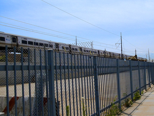
For such an important facility, the security at the Sunnyside yard is abyssmal. This, for instance, is the security fence on Skillman. Graffiti observed along the tracks and the numerous reports of urban explorers speak to the time and opportunity afforded trespassers- who ignore the dangers of crossing active tracks, electrified rails, and all sense of personal safety. Let’s be clear- without special training and equipment- you can easily get killed down there. I also think its the greatest unused location for a motion picture I’ve ever seen.
click here for trainsarefun.com’s LIC and Sunnyside yard page (with historical photos and maps!!!)

Skillman Avenue -photo by Mitch Waxman
Anywhere you point a camera on Skillman Avenue, you will find a great shot. The only hassles I’ve ever had here (a deserted street on the weekends, especially holidays) were from union guys asking me what I was doing, which wasn’t really a hassle. They were pretty cool, they were just checking I wasn’t “an environmentalist” trying to jam them up. Amtrak security rolls by, but never stops to ask questions. Cops breeze by and don’t even slow down as they pass your humble narrator while he is using a tripod.
Here’s what one of the MTA’s architects proposes for the far end of the Yard.

New York City skyline and Sunnyside Yard from Skillman Avenue -photo by Mitch Waxman
Not that long ago, this was the most important place in Queens, and the gateway for freight into Manhattan from all points east. It is still a critical part of the transportation infrastructure of New York City, but the empty factories- and worse- the subdivided ones speak to the economic might which was won, and has since been lost around the Sunnyside Yards.

Skillman Avenue -photo by Mitch Waxman
Quoting from one of Newtown Pentacle’s earlier posts– and yes, I know the Degnon terminal is at the other end of the Yard close by the Dutch Kills:
Astoria and Sunnyside provided a large number of the 16,000 employees who worked here at the Degnon Terminal, almost all of whom belonged to labor unions. These were jobs “with benefits” like health insurance or paid vacations, a rarity before the late 1970’s. The shells of the titanic companies like Adams (Beeman) Chewing Gum, and Sunshine Biscuits line the streets surrounding the yard, but modernity has largely cut their links to it.

Turn Left on Skillman Avenue at 36th street -photo by Mitch Waxman
Wow, some walk so far. Dutch Kills is so close, and so is the residential section of Long Island City… but we need to make a left on 36th street and south toward the Boulevard of Death…
Lurking… in fear- or Astoria to Calvary, part 2
Here’s a google map (including part 1 of this walk).

Dwyer Square -photo by Mitch Waxman
Perhaps…
The world knows all that it ought to know of Western Queens, and would remain merry in the satisfied ignorance of modernity- were it not for we Newtownicans who force it to disgorge its centuried secrets to feed the ravenous panopticon. Shudder at revelations of this history, found at our altar of a forgotten cosmos, for its implications may force one to experience monstrous alterations of dream. No rock in this part of the great city can be overturned without portent, or absent the mocking laughter of those who once walked these titan arcades of the Newtown Pentacle.
from the nyc.gov website
Located in the northwestern Queens neighborhood of Astoria, Dwyer Square lies near an old Native American trail (Woodside Avenue) that served as the main road from western Queens to the village of Newtown during the early American Colonial Period. The road ran along a tongue of dry land between the swamps of Long Trains Meadow (towards present day Jackson Heights), Wolf Swamp (towards present day Maspeth), and Burger’s Sluice (along present day Northern Boulevard). Hessians during the American Revolution (1775-1783) garrisoned this strategic point. In 1713 Isaac Bragaw, a descendant of one of the earliest French Huguenots in New Amsterdam, purchased this land. During the early 19th century, William Gosman purchased the farm. (Gosman is also known for having surveyed and laid out the area’s streets around 1875). Also nearby lies Northern Boulevard, an important six mile road connecting Flushing to Hunters Point.
It was originally named Jackson Avenue for Turnpike President John C. Jackson, whose leadership and efforts made the road possible. Costing nearly $40,000 and opening on July 13th, 1860, the highway was originally composed of milestones, a gravel roadbed and a tiny tollhouse and gate where travelers would pay a nine cents fee for passage. Foot traffic, however, was free.
In September 1980, the City of New York rededicated Dwyer Square. The square contains a flagpole with a yardarm that flies the United States, City of New York, and Parks flags; brick and concrete walkways; benches; and five trees, including three Japanese pagoda trees (Sophora japonica), a honey locust (Gleditsia tricanthos), and a green ash tree (Fraxinus pennsylvanica).

48th street between Northern Blvd. and 37th avenue looking west -photo by Mitch Waxman
At the commercialized intersection of 48th street and Northern Blvd. make a right and find the spot where- in 1932 the Madison Square Garden Bowl attracted a degenerate population of gamblers and all those friends and companions of night who accompany the sporting life- and near the spot selected by the US Army in WW2 to locate its titanic mail sorting and postal concentration operation– and close to where Ronzoni’s Pasta Mill stood- is today a shopping mall anchored by discount stores and an ice cream shop.
Gaze west upon the terrible grandeur of the shield wall of Manhattan, lying beyond Newtown across the River of Sound. By the 1970’s, this industrial complex had decayed and fallen prey to the greater malaise which infected New York until just recently. Described to the Newtown Pentacle as abandoned buildings and brick lots, it was home to vermin of all descriptions.
Apocryphal stories passed down by native Astorians speak of queer pock marked and needle scarred characters conducting odd rites in these ruined industrial sites as early as the 1970’s, with the officials in City government only intervening in these midnight gatherings when carelessly lit fires began to plague the area and a jump in the rate of suicide and violent robbery was commented on by many. A whispered Queens patois answers questions put to these lifelong Newtownicans about the place, apocryphally saying that it was where drug fiends and street gangs would hold congress, spending their nights amongst the oddly shaped shadows cast by streetlight streaming through broken windows (typical of similar vacant properties in the greater city, during that degenerate period of shattered and diminished expectations).

LIRR crossing at 48th street and 37th avenue -photo by Mitch Waxman
A side effect of the medications which maintain my frail physique in some semblance of balance- an exotic cocktail representing the highest pinnacle of the chemist’s art- is a vulnerability to an outward bodily manifestation of my subconscious notions- both gross and ridiculous. Without obvious provocation, a series of terrified and hysterical shrieks may emerge from my throat, owed entirely to my nervous and cowardly temperament. These nervous attacks are some surface manifestations of a deeper sensitivity, and suggest the buried neuroses which compel my quixotic and noisome nature. I have learned, when this humiliating condition is approaching, that by changing my course and altering my visual environment, I can often prevail against these terrors by resetting my nervous equilibrium.
It is terrible to have one’s mind couched in such an inferior physical example of the specie, and I have often considered alternatives. Oh, mankind, like a leaf- you.
So, we’re making a left onto a vestigial remnant of an earlier street grid, one that existed before the 800 pound gorilla and the Sunnyside Yard came to town- 37th avenue.

S.E.M./Signals Street Light Yard -photo by Mitch Waxman
On the south side of the street lies the elevated trackbed of the LIRR, and a series of garages which until recently served the nearby Sunnyside Yards. Many businesses in this area, which is defined by the gargantuan rail yard, have had their leases vacated by the MTA and LIRR recently. Sunnyside Yards is about to expand. On the north side of the street are two enormous structures, the first of which is a municipal building- the S.E.M./Signals Street Light Yard. Its yard, which consumes most of its lot, houses stores of street furniture and municipal hardware- and the sturdy employees of the place reveal their kind hearted nature by the carefully cared for colony of cats seen stalking the yard fencelines. Obviously capable hunters, some of the cats carry half eaten things that squeal and scream.

S.E.M./Signals Street Light Yard -photo by Mitch Waxman
I couldn’t find much out about this enigmatic and clearly decaying structure, but I did find a link to the New York City DOT Street design manual. (6.8 meg pdf). Other than that, I can find no proof at the Dept. of Buildings that this structure exists. It is anomalous, but clearly it can be photographed, which confirms it is no phantasmagoria nor an hallucination.

S.E.M./Signals Street Light Yard -photo by Mitch Waxman

“No Photography Allowed” -photo by Mitch Waxman
Across the street from the anomalous facility are a recently emptied series of garage sheds which were utilized by the Sunnyside Yards as some sort of machine shop. Signage disallows photography, but should mention grafiti instead. Such street scrawls, the joy of adolescent boys worldwide, is evidential of the lack of attention paid to security by civil and private authorities to these places that are not visible from their shining towers in Manhattan. Disturbingly, the graffiti writers are provided with both time and opportunity to pursue their art, which adorns every train viaducts and even the offshore Brooklyn Bridge moorings. One wonders who and what else may wander these streets looking for just such an opening, and what esoteric desires they may be seeking to fulfill.
LIRR -photo by Mitch Waxman
Like Jason tied to his mast before the fabled Sirens, my attention was suddenly centered and transfixed. My eyes blurred as the powerful air horn of a LIRR train heading for eastern Long Island passed a construction site- screaming wildly in accordance with federal regulations. Unbalanced by the sudden rush of air and sound, I staggered forward several steps to avoid falling, and became transfixed by the nearby construction site. Such variability and inability to stay focused in the face of visual stimuli is undoubtedly the end product of an undisciplined childhood, an upbringing upon which I insisted on despite the best efforts of my simple parents.

LIRR track work -photo by Mitch Waxman
Up until just a year ago, this was a weed choked dumping ground for area residents and passing building contractors. The engineers of the LIRR have recently reinforced the track bed with structural steel and are in the process of armoring it in a wall of cement tile, as part of the larger East Side Access Project . I am not sorry, for I hated both antique wreckage and hellish vegetation which polluted the artificial ridge and occluded viewpoints of these gleaming trains as they carry their mutitudes back and forth to Manhattan.

New York Presbyterian Church – “stitched panorama” photo by Mitch Waxman
click here to see the ridiculously large original- warning-BIG FILE
Across the street is an enormous Church complex, the New York Presbyterian. It has all the appearance of a fortress, complete with a guardhouse possessed of mirrored windows and a retinue of antennae and cameras, but this would be normal for any structure of this size which abuts one of the largest and most important rail yards in North America. The curious asiatic script found on the church’s signage, and indeed the characteristic wide grin and relaxed countenance of the members of the congregation I have observed show all the hallmarks of origins on the Korean Peninsula. This is an assumption of course, based solely on study of New York’s ever shifting demography.
Here’s what archi-tourist had say:
This massive church is located in a strange area between the suburban, automobile landscape of Northern Boulevard and the planned community of Sunnyside Gardens. The LIRR passes alongside the church and 37th Avenue, adding to the feeling that the church doesn’t really belong to any place, any neighborhood.
The plan is basically split into three areas: a large congregation space fronted by the large wall of translucent panels and the church’s entry, the art-deco front on 37th Avenue now containing classrooms and other small spaces , and a series of metal-clad shells concealing the exit stairs required for the large, 2,500-seat sanctuary. All is surrounded by acres of parking, some at the level of the entry, some one-story below grade on the building’s north side.
It’s the building’s north side and its series of angular, metal scallops that gives the church its most striking feature, even though this facade is the most removed from the entry, the road, and the railway. It’s also ironic that so much effort was expended on a feature that’s rarely used, as these pieces cover the exit stairs from the sanctuary. But perhaps that’s the point; that the design needed some sort of POW or hidden surprise that couldn’t find its way into the art deco piece or the main sanctuary.
They seem like very nice people, despite the forbidding appearance of the structure that houses their church. The adoption of Protestant Christianity by a large segment of the Korean population was facilitated relatively recently, as it turns out.

New York Presbyterian Church – photo by Mitch Waxman
from wikipedia
In 1884, two American missionaries came to Korea: Henry Appenzeller, a Methodist, and Horace Underwood, a Presbyterian.[2] Emphasizing the mass-circulation of the Bible (which had been translated into Korean between 1881 and 1887 by the Reverend John Ross, a Scottish Presbyterian missionary inManchuria), the Protestant pioneers also established the first modern educational institutes in Korea. The Presbyterian Paichai School (배재고등학교) for boys was founded in 1885, and the Methodist Ehwa girls’ school (이화여자고등학교) followed a year later. These, and similar schools established soon afterwards, facilitated the rapid expansion of Protestantism among the common people, and in time enabled the Protestant faith to overtake Catholicism as the leading Christian voice in Korea.
and
Korean Americans in America have historically had a very strong fundamentalist and conservative Christian heritage. Between 70% and 80% identify as Christian; 40% of those consist of immigrants who were not Christians at the time of their arrival in the United States. There are about 2,800 Korean Christian churches in the United States, as compared to only 89 Korean Buddhist temples; the largest such temple, Los Angeles’ Sa Chal Temple, was established in 1974.

Stop, make left on 43rd street -photo by Mitch Waxman
A wall of shadowed brick will greet you as you reach 43rd street, and you must choose as I am forced to- do you return to Northern Blvd. and the greater world beyond- whose every path leads to the great gleaming metropolitan city and its myriad pleasures? Or will you choose to take a left handed path, and plunge deeper- ever deeper- worming your way into the darker heartlands of the Newtown Pentacle?

43rd street and 37th avenue -photo by Mitch Waxman
Steadying myself and resolute to continue, I stopped on the corner to consider 37th avenue and noted the sudden change in environmental conditions after crossing the street. A tenebrous darkness clings to this corner- the smell of mildewed wood and nitre dripping cement- mixed with urine- colors the air a yellowish brown. Somewhere nearby, is something that reeks of degenerate humanity.
note: I’m not kidding about the weird darkness here, check it out in google street view.
Moving south on 43rd street, and passing beneath a steel bridge which is manned by an actual troll… a sort of creature whose name the local Croatians might roughly translate into english as a “Sin-Eater“.
Crossing the angles between spaces -photo by Mitch Waxman
But brave this trollish hazard we will, my ladies and lords of Newtown, for the strange energies which course through the ground in these intermediate zones- which are neither one neighborhood nor another– these places- they are just existential hinterlands which reside in the angles found between them.
And we are on the verge of entering the most progressively designed, rationally proportioned, and ultimately verdant section of the long walk from Astoria to Calvary. Netownicans, we are about to pass under and over and enter into the Sunnyside.
A Big Dig in Queens
Sorry for the quotidian nature of parts of this post, but if someone says it better and more succinctly than you can- just acknowledge and accredit the source I always say.

Sunnyside Yards, Degnon Terminal- photo by Mitch Waxman
An Observation:
Good old fashioned “Progress” is on the move again in the City of Greater New York.
Sunnyside Yards, from Skillman Avenue- 3 exposure HDR photo by Mitch Waxman
Along the east side in Manhattan, a new subway line is under construction. The project has called for an expansion of the Long Island Rail Road’s cyclopean Sunnyside railyards at the Degnon Terminal here in Queens. (ps- check this video of a ride on the 1950’s Manhattan Third Avenue El at YouTube).
Quoted content from trainsarefun.com
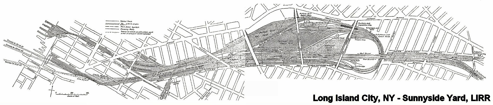
Sunnyside Yard Rendering C. 1905
In 1910 the Pennsylvania Railroad had completed its terminal in New York City, which was connected by tunnels to New Jersey, and under the East River to Long Island. At Sunnyside the large yard of the Pennsylvania Railroad was constructed. An agreement was made with that Railroad and the Pennsylvania Tunnel and Terminal Railroad Company whereby the cars of the Long Island Railroad would be carried through the tunnels under the East River into the Terminal at Seventh Avenue and Thirty-second Street, New York. Thus the Long Island Railroad acquired what successive administrations had striven for in vain, a terminal on Manhattan Island. In order to reach this terminal it was necessary to electrify from Jamaica to New York, which was accomplished in 1910, and the first train run into the Pennsylvania Station on September 10th of that year.
-Felix E. Reifschneider’s 1925 Long Island Rail Road History
I REALLY have to recommend some time spent at Trainsarefun.com for any antiquarian, and especially for the intrepid photographer trying to peel back a few layers. This is one of the best collections of old photos and maps on the Long Island City and Newtown Creek industrial complexes that I’ve found so far. Wow. This is the link to their LIC page (same as one on accredidation).

Sunnyside Yards, Degnon Terminal- photo by Mitch Waxman
The Plan:
as quoted (verbatim) from the wikipedia article on the subject:
Extending between Sunnyside, Queens, and Grand Central Terminal, the East Side Access project will route the LIRR from its Main Line through new track connections in Sunnyside Yard and through the lower level of the existing 63rd Street Tunnel under the East River. In Manhattan, a new tunnel will begin at the western end of the 63rd Street Tunnel at Second Avenue, curving south under Park Avenue and entering a new LIRR terminal beneath Grand Central Terminal.
Current plans call for 24-trains-per-hour service to Grand Central Terminal during peak morning hours, with an estimated 162,000 passenger trips to and from Grand Central on an average weekday. Connections to AirTrain JFK at Jamaica Station in Jamaica, Queens, will facilitate travel to John F. Kennedy International Airport from the East Side of Manhattan.
A new LIRR train station in Sunnyside at Queens Boulevard and Skillman Avenue[1] along the LIRR’s Main Line (into Penn Station) will provide one-stop access for area residents to Midtown Manhattan.[2] The station may spur economic development and growth in Long Island City.
A comment:
Once again, the recurring theme of “spurring development and growth in Long Island City” emerges. Look at the photos here at the Newtown Pentacle, go to our flickr group and see what other people are compelled to record and share. Does this place look undeveloped or undergrown? These are real estate interests talking, trying to grab away what remains of New York’s industrial infrastructure. These buildings are full of companies that employ people in low paying jobs that you don’t need a diploma or even ID to get. Greasy, necessary jobs handling garbage and other things you wouldn’t like to think about. Abattoirs and crematories are part of the story, like sewers and trains, of the greatest metropolis in the history of mankind.

Sunnyside Yards, Degnon Terminal- photo by Mitch Waxman
Minutia:
Degnon Terminal and the Sunnyside Yards are so large and obvious from the air, so critical to the economy and strategic operational capabilities of the United States- that they were designated by the Soviet Union’s Missile Forces as the first strike target in a nuclear attack on the New York Metropolitan area, not Manhattan (which is only a mile and half away, mind you, and would have been obliterated along with the yards).
– I’m trying to back that one up right now, but its something I read a while back- perhaps at conelrad, I’ll find my source on this- I just have to stop looking
-Astoria, incidentally, is where the famous “Duck and Cover” propaganda flick was made (here’s the youtube link).
Astoria and Sunnyside provided a large number of the 16,000 employees who worked here at the Degnon Terminal, almost all of whom belonged to labor unions. These were jobs “with benefits” like health insurance or paid vacations, a rarity before the late 1970’s. The shells of the titanic companies like Adams (Beeman) Chewing Gum, and Sunshine Biscuits line the streets surrounding the yard, but modernity has largely cut their links to it. These industrial buildings- filled piecemeal with dozens of smaller companies- load their containerized goods onto trucks, not trains, and the international port that will ship their products is in Newark, New Jersey.
Sunnyside Yards, this street corner is actually on a bridge over the yards- notice the change in elevation at lower left- still around 30-50 feet (10-15 meters) over the tracks– The structure at horizon is another road bridge over the yards. –3 exposure HDR photo by Mitch Waxman

Sunnyside Yards, Degnon Terminal- photo by Mitch Waxman
An opinion:
These sort of tectonic shifts in the landscape are nothing unusual in New York City, which is not so much a series of individual structures as it is an enormous complex of infrastructure whose every perspective is ultimately centered on Manhattan and whose borders ultimately lie hundreds, if not thousands, of miles away radiating in every direction including out to sea and in the air.

Sunnyside Yards, Degnon Terminal- photo by Mitch Waxman
Here in the Newtown Pentacle, near the very center of this Megalopolis– centuries of power, phone, water, and sewer systems weave around layered building foundations, abandoned trolley lines, and the legacy of the industrial revolution. Deep under the streets, streams and creeks that once ambled over the stubborn hills of New Amsterdam now crash through stone clad sewers in a century clad darkness, mixing with industrial runoff and raw sewage. Even under the best of circumstances, a lot of New York’s untreated waste ends up in the harbor. A significant portion of that dumping, by the City of New York, happens at Newtown Creek.

Sunnyside Yards, Queensboro Plaza Side, also a bridge over the yards- photo by Mitch Waxman
A warning:
In the very near future, vast new residential populations are envisioned to live nearby- at Hunter’s Point, and Queensboro Plaza, and all around the Sunnyside yards, if “growth is spurred”. I’m just an observer, but I’ve watched condo developers carving bloody chunks out of Long Island City, reducing enigmatic and functional structures down to a neighborhood eerily reminiscent of Battery Park City. These new developments are not required to improve the sewers, or build subway stops, or even compel the local electric company to improve the quality of its archaic grid. Can these ancient Newtown foundations support a magnified community they were never designed for?

Newtown Creek Bulkheads- photo by Mitch Waxman
On the waterfront(s), these waters flow into forgotten subterranean vaults, and flow through depression era landfills, swirling through long buried smuggler tunnels and abandoned building foundations on their pathway to the river– silt buried structures which await only the discovery of modernity. All the poisons which lurk in our Newtown mud leech into the water, eventually percolating into the East River and New York Harbor beyond.

Sunnyside Sewer- photo by Mitch Waxman
Who can imagine what might be buried down there, under all the layers of progress, and what the Big Dig in Queens might be stirring up?

Sunnyside Yards, Degnon Terminal- photo by Mitch Waxman
ps: Check out this video at Youtube for sound reasoning on why New York was the center of the universe– it’s Geography!
“Influence of Geography & History on Port of New York 1949”


