Archive for the ‘New York Harbor’ Category
family photos
Check out the work of our Lady of The Pentacle, me missus, as she exhibits our weekend excursion to the wilds of the Long Island Gold Coast and exploration of the Vanderbilt Mansion. Her blog post about it is here, and check out her flickr slideshow
Here’s a flickr slide show of my own, detailing the recent Breezy Point Ferry trip I was on (I’ll be doing a proper post on this later on this week). Check out NY Harbor at dawn…
Another crazy series of experiences is underway, hundreds and hundreds of new photos are in the oven right now…
Kill Van Kull walk 2
for part one, click here

– photo by Mitch Waxman
The Kill Van Kull is an industrial waterway which provides a border between Staten Island and New Jersey, as well as serving the role of a maritime route between the Port of Newark and the greater body of water called New York Harbor or the New York Harbor Estuary- depending on your priorities. The New Jersey side of the Kill Van Kull is lined with modern docks and industrial facilities. The Staten Island side seems to have abandoned its industrial role, with storm shattered pilings and relict rail tracks found lining its banks.
from wikipedia
New York Harbor lies at the confluence of three major bodies of water. The harbor opens onto the New York Bight (Atlantic Ocean) to the southeast and the Long Island Sound to the northeast. Both of these are essentially marine bodies with both tides and saltwater, but the Sound compared to the Atlantic is about 20-30% less saline (as an estuary), and the tide is about 3 hours later with as much as 70% more variation. The Hudson River adds a fresher, non-tidal inflow from the north, although the tide and brackishness extend well up river.

– photo by Mitch Waxman
Critters abound along this cement clad shore, and large flocks of coastal and ocean fowl may be observed. My ignorance of the natural world is an ongoing handicap (why can’t I know everything about anything? … human… all too… human…) so I cannot describe the taxonomy of these birds. Perhaps a helpful Newtown Pentacle reader with ornithological knowledge can assist in identifying the specie observed above. I can tell you that they were apparent in great numbers, during the early days of March.
UPDATE: Sharp eyed reader Christina informs me that these are Brant Geese.
from army.mil
The U.S. Army Corps of Engineers New York District recently shared its plans to improve the New York – New Jersey Harbor Estuary with members of Congress and other key decision-makers. Representatives of more than 20 organizations joined the District commander aboard the USACE vessel Hayward tour of the estuary and the Hudson River.
“It’s the 400th anniversary of Henry Hudson’s historic exploration up this great river,” said Col. John R. Boulé II, New York District commander, addressing the group from the bow of the Hayward. “Our view must be very different from his. Years of industrialization have considerably degraded this part of the Hudson.”
The Corps plans to help turn back the hands of time on the estuary. The event to celebrated the unveiling of an innovative, comprehensive restoration plan created in collaboration with partners, and with a focus on restoring the estuary. This will create a healthier environment for fish and wildlife, and also provide the public cleaner waters, healthier fisheries, increased flood protection, recreational opportunities, and a boost to the region’s economy.
“The primary goal of the New York-New Jersey Harbor Estuary Comprehensive Restoration Plan is to develop a mosaic of habitats that provides maximum ecological and societal benefits to the region,” said Lisa Baron, project manager and marine biologist with the New York District.
A diverse group of USACE technical experts and consultants developed the plan as part of the Hudson Raritan Estuary Ecosystem Restoration Study sponsored by the Port Authority of New York and New Jersey. The plan was prepared in collaboration with the New York-New Jersey Harbor Estuary Program and more than 60 partnering organizations, including federal, state and local agencies, non-governmental organizations and regional stakeholders. The overall plan is unique in that these agencies are presently combining their funds and forces to reduce redundancy, become more efficient and save taxpayers a considerable amount of money. The plan will serve as a master guide and framework for restoration efforts throughout the estuary.
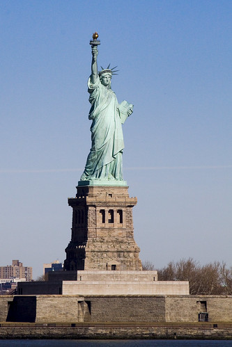
The plan involves many partners because the estuary spans 1,600 square miles across New York and New Jersey. An estuary is the area where the fresh waters of a river meet the salt water of the sea. The New York-New Jersey Harbor Estuary includes rivers, wetlands, coastline and open waters, and is located within a complex ecological system and a metropolitan region with a population of 20 million people. The plan’s boundary covers a large region of the estuary, which is a 25-mile radius around the Statue of Liberty National Monument.
“To perform restoration work in the estuary, the plan divides the estuary into eight regional areas associated with specific watersheds,” said Peter Weppler, chief of the New York District’s Coastal Ecosystem Section. He is a biologist with an extensive background in ecological investigations.
The plan includes 11 priority targets for restoration, recognized as Target Ecosystem Characteristics that include methods to restore and create habitats, ensure these habitats live in harmony and with the surrounding urban infrastructure, and to ensure the estuary is safe and accessible to the millions of estuary residents and visitors.

– photo by Mitch Waxman
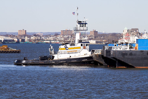
The big show on the Kill Van Kull, of course, are the Tugboats transiting between the lower Harbor and the Port of Newark. Tugboats, for those of you unfamiliar with the role they are engineered to perform, act as precision guides that pilot and nudge ocean going vessels through the relatively shallow and tight quarters found in coastal waters. Powered by engines many times more powerful than required for vessels of their size and tonnage, Tugs are also designed with specially stiffened and overly robust frames which allow them to manipulate the elephantine ships that they shepherd to safe harbor. Pictured above is the Jill Reinauer. For an interesting window on the life of a tugboat crew and the hazards they face in New York Harbor, check out this post at piersystem.com.
from tuginformation.weebly.com
Built for Interstate Oil Transport by Main Iron Works of Houma, La in 1967 (hull #183) as the tug Ranger. She measures 91’(ft) long, with a 9’(ft) draft and 26’(ft) wide rating at 2,000 horsepower.
At the time Interstate Oil Transport had two fleets. Their Northeast Fleet “Green Fleet” that operated in Philadelphia, Pennsylvania. And a Southern Fleet “White fleet” which operated out of Tampa, Florida. The Ranger was assigned to the “Green Fleet.” However, many changes came to Interstate Oil, a company called Southern National Resources (also known for a time as SONAT Marine) purchased Interstate Oil Transport. SONAT eventually sold out to Maritrans Operating Partners LLP.
In 1998, Maritrans’s northeast fleet was thinned. Many of the vessels where acquired by K-Sea Transportation Partners. Reinauer Transportation acquired three vessels, the Ranger was one of the three vessels. She was renamed the Jill Reinauer the others vessels Reinauer acquired where the Interstate Transporter (Kristy-Ann Reinauer), and the Delaware (Curtis Reinauer). In 2005, the Jill Reinauer was re-powered with MTU engines and fitted with canted windows in her main wheelhouse to reduce glare in the wheelhouse, and was fitted with an upper wheelhouse as well, this work was done at Reinauer’s yard in Staten Island, New York.

– photo by Mitch Waxman
A sudden flurry of activity on the Kill Van Kull began when the Charles D. McAllister sped by, after having passed beneath the elegant Bayonne Bridge (designed by Omar Othman under the guidance of Gustav Lindenthal, who designed the Hells Gate Bridge spanning the East River nearby storied Astoria). For a different perspective on the Kill Van Kull and lots of information on the Chemical Coast of New Jersey, Bayonne Bridge, and Port of Newark- check out the Newtown Pentacle postings from June of 2009 here, and here.
also from tuginformation.weebly.com
Built in 1967 as the Esso Bayou State by Jacksonville Shipyard of Jacksonville, FLA. Rated at 1,800 horsepower she is driven by two Caterpillar 12-D398 Turbo main engines, with Lufkin reduction gears with a ratio of 7.14:1 She is a twin screw tug, fitted kort nozzles and flanking rudders. She is outfitted with two fire monitors that produce 1,500 Gallons Per Minute. She has a fuel capacity of 26,670 gallons, 628 gallons of Lube Oil and 3,480 gallons of potable water.
She was later renamed the Exxon Bayou State, and when Exxon became Sea River Maritime, her name was altered to S/R Bayou State. When Sea River sold off their assets she was acquired by McAllister Towing and Transportation she was renamed the Charles D. McAllister and is currently assigned to McAllister’s New York, New York fleet.

– photo by Mitch Waxman
Moran towing’s Cape Cod shot past at what seemed to be it full 4,200 HP throttle, undoubtedly in an urgent rush. Note the lesson in physics illustrated by the waveforms around the speeding tug. The warping of the water’s surface illustrate the principles of displacement, surface tension, and offer visible waveforms for study.
from tugboatenthusiastsociety.org
Tugs are “displacement” hull vessels, the hull is designed so water flows around it, there is no consideration for having the vessel “plane”. Because of this the hull form is limited to a maximum speed when running “free” that is about 1.5 times the square root of the waterline length. As the tug approaches this speed when running “free” it is perched between the bow wave and the stern wave. Since the hull cannot plane, application of additional power when approaching maximum hull speed only results in a larger bow wave, with the tug “squatting” further into the trough.

– photo by Mitch Waxman
The Amy C McAllister was next on the parade, and it seemed to also be in quite a hurry. Something was approaching, something big.
also from tuginformation.weebly.com
Built in 1975, she was formerly named the Jane A. Bouchard. She is fitted with two EMD 16-645-E2 main engines for a rating of 4,000 horsepower turning two Falk reduction gears at a ratio of 4.708:1. She is also fitted kort nozzles, and flanking rudders with a Smatco single drum towing winch outfitted with 2,200′ (ft) of 2 ¼” (in) towing wire. When she was acquired by McAllister Towing and Transportation she was renamed the Amy C. McAllister.
She is currently assigned to McAllister’s New York, New York Fleet.

– photo by Mitch Waxman
Turns out that “something big” was the Eagle Beaumont, a gargantuan fuel ship which was flagged in far off Singapore. Sources reveal that the Eagle Beaumont is an “aframax tanker“, was built at the Korean Samsung Heavy Industries Yard in 1996, has a maximum DWT of 99,448, and is a double hulled vessel classified as “1A1 Tanker for Oil ESP E0 LCS-SI” with a worth of some $52 million.
from aet-tankers.com
AET’s double-hulled VLCC fleet is managed from London and is mostly engaged in the Atlantic trades, as well as longer haul trips to the US West Coast. There are currently 11 vessels in this fleet with an average age of less than five years. Growing VLCC capability is a priority and we are on target to achieve a 25-strong fleet within the next five years.
The fleet of aframax vessels forms the core of AET’s crude oil activities. All double-hulled and with an average age of around 9 years, these workhorses of the tanker industry transport crude oil in Europe, Asia and the Americas. This fleet and its global footprint will continue to grow, to provide increased connectivity between geographic regions and between our VLCC operations and our lightering activities.
AET vessels are employed for customers on long-term period charters, shorter voyage charters or on extended contracts of affreightment (COAs). The dedicated chartering teams in London, Singapore, Gurgaon and Houston work alongside our customers to ensure we deliver the best possible solutions.

– photo by Mitch Waxman
The two tugs maneuvering the Eagle Beaumont in the narrow space of the Kill Van Kull are the aforementioned Amy C. McAllister and a second McAllister tug which escapes my identification due to the shadows cast by the titanic fuel tanker. My suspicions point to the Charles B. McAllister, but the wheel house exhibits minor differences from the shot above, so I’m probably wrong. At any rate, they performed a rotation of the tanker using sturdy cables and precision coordination of effort.
from wikipedia
Tankers used for liquid fuels are classified according to their capacity.
In 1954 Shell Oil developed the average freight rate assessment (AFRA) system which classifies tankers of different sizes. To make it an independent instrument, Shell consulted the London Tanker Brokers’ Panel (LTBP). At first, they divided the groups as General Purpose for tankers under 25,000 tons deadweight (DWT); Medium Range for ships between 25,000 and 45,000 DWT and Large Range for the then-enormous ships that were larger than 45,000 DWT. The ships became larger during the 1970s, and the list was extended, where the tons are long tons:
- 10,000–24,999 DWT: General Purpose tanker
- 25,000–44,999 DWT: Medium Range tanker
- 45,000–79,999 DWT: Large Range 1 (LR1)
- 80,000–159,999 DWT: Large Range 2 (LR2)
- 160,000–319,999 DWT: Very Large Crude Carrier (VLCC)
- 320,000–549,999 DWT: Ultra Large Crude Carrier (ULCC)

– photo by Mitch Waxman
From the direction of the Port of Newark, a behemoth container ship suddenly appeared. Notice how high it’s riding in the water, signifying that its pessimistically half empty. A Liberian flagged 231 meter long by 32 meter wide ocean going vessel, it was built in the year 2000, and is capable of moving at 21.1 knots. Another product of the Samsung Heavy Industries yard in Korea, it’s the Santa Carolina.
from wikipedia
Samsung Heavy Industries or SHI (Korean: 삼성중공업, Hanja: 三星重工業) is the second-largest shipbuilder in the world and one of the “Big Three” shipbuilders of South Korea. A core subsidiary of the Samsung Group, South Korea’s and the world’s largest conglomerate, SHI’s main focus is on shipbuilding, offshore floaters, digital devices for ships, and construction and engineering concerns.
SHI operates manufacturing facilities at home and abroad, including ship block fabrication factories in Ningbo and Rongcheng, China. The Geoje Shipyard in particular, SHI’s largest shipyard in South Korea, boasts the highest dock turnover rate in the world. The largest of the three docks, Dock No. 3, is 640 meters long, 97.5 meters wide, and 13 meters deep. Mostly ultra-large ships are built at this dock, having the world’s highest production efficiency with yearly dock turnover rate of 10 and the launch of 30 ships per year.[2]
SHI specializes in the building of high added-value and special purpose vessels, including LNG carriers, off-shore related vessels, oil drilling ships, FPSO/FSO’s, ultra Large container ships and Arctic shuttle tankers. In recent times SHI has concentrated on LNG tankers and drillships, for which it is the market leader.

– photo by Mitch Waxman
The Laura K. Moran tug appeared, and took up its position to guide the Santa Carolina through the narrow hazards faced by the Santa Carolina passing by the Eagle Beaumont. Realize that a ship of this size is incapable of stopping on a dime, and the dynamics of such massive objects suggest vast kinetic energy transfers should they accidentally come in contact with other objects. An interesting point of language, interesting to your humble narrator at least, in the correct usage of the words allision and collision. An Allision is used when a moving object strikes a fixed object- i.e. when a ship strikes a pier or shoreline feature. A Collision is when two moving objects meet. The job of the Tugboat Captain is to avoid either.
from boatinglaw.com
When one thinks of admiralty law the archetypical fact pattern that comes to many people’s minds is a collision or allision (vessel contact with a fixed object). There are many well ingrained legal concepts and rules, some of which are unlike anything found in land based law.
First, when there has been a collision or allision the vessel herself may be sued as if she were a person. This is an “in rem” action and the complaint is against the vessel her tackle her engines and appurtenances.
Second, under general maritime law, each vessel must pay in proportion to the amount that it was at fault. This rule stands in stark contrast to state law in a those states, including Maryland, where plaintiffs who bear any fault can be barred from all recovery.
Third, there are several judicial presumptions of fault that all vessel operators should bear in mind. A vessel creating wake is presumed at fault for damage caused by wave wash. A vessel in violation of any safety statute which could have prevented the casualty is presumed at fault. A vessel that is drifting or dragging anchor is presumed at fault. A vessel that allides with a fixed object (unless it is submerged) is presumed at fault.
Fourth, there are several sources of fault in addition to the judicial presumptions including, statutory violations, local rules, unseaworthiness of your vessel and custom. If you violate a custom you may well find yourself liable for the casualty. A prime example of a custom is the Point Bend Custom on the Mississippi River. Since the current flows fastest on the outside of a bend and slower under a point of land, all downbound traffic travels around the outside of a bend while upriver traffic takes advantage of reduced current by traveling from point of land to point of land. This creates a situation in which large vessels must weave through each other’s paths.

– photo by Mitch Waxman
In fact, the two ships were quite a distance from each other, but in nautical terms, this is a tight squeeze for the vagaries of displacement and current are somewhat unpredictable. The Tug crews that inhabit New York Harbor carry a knowledge passed from father to son and captain to deckmate, and represent millions of hours of applied labor and hard won familiarity with the liquid thoroughfare of the Kill Van Kull. No room for error is to be found as they nudge and pull, and mistakes can be deadly to crew and environment alike. The Kill Van Kull is only a thousand feet wide, after all.
from shipsnostalgia.com
Errors in judgment by the navigators aboard two tanker ships carrying volatile cargos resulted in a collision, explosion and fire that consumed both tankers, two attending tugs and left 37 sailors dead and more than 20 injured in New York harbor on June 16, 1966.
The fiery accident remains counted even today as among the deadliest shipwrecks in the history of New York Harbor.
The tankers, the British MV Alva Cape was entering the harbor with a cargo of naphtha and was struck amidships on the starboard side by the outgoing American tanker Texaco Massachusetts. The raging explosion and fire that resulted from the crash destroyed not only the tankers but the tugs Latin America and Esso Vermont.
Thirty-four sailors perished during this first explosive event on July 3. Nineteen of them perished on the Alva Cape, eight on the Esso Vermont, three on the Texaco Massachusetts and three on the tug Latin America. The U.S. Navy, Coast Guard and New York City fire boats worked together to battle the flames and rescue as many sailors as possible from the burning vessels in a place with the ominous name of Kill Van Kull Channel.
The blaze was finally extinguished, but the Alva Cape was not finished as a human death trap. Three more men were killed in yet another explosion while they were aboard the burned out wreck, attempting to unload what remained of its deadly cargo. This happened just 12 days later, bringing the death toll from the accident to 37.

– photo by Mitch Waxman
Along the Staten Island coastline, an abandoned rail line is observed. Forgotten-NY has rolled through here, and as always, wrote the book on Cornelius Vanderbilt’s SIRT.
check out the words of the Master- click here

– photo by Mitch Waxman
Inheritances of the industrial revolution such as these rusted tracks litter the North Shore of Staten Island. The lovely homes and tree lined streets nearby are sited, unfortunately, amongst the toxic inheritances of the heroic age of the mills and factories which defined the area- which cause your humble narrator to muse on analogies to Maspeth and Greenpoint, found along the route of the malefic Newtown Creek as it gurgles along the currently undefended border of Brooklyn and Queens.
from wikipedia
Much of the North Shore is industrialized, which when paired with the fumes being exuded from New Jersey factories, helps to give Staten Island the worst smog in New York City. According to the New York State Department of Health, deaths from lung cancer are 48% higher on Staten Island than in the city as a whole. The poorest air quality being on the North Shore of the island. Within the North Shore’s approximately 5.2 square mile area, there has been around 21 different sites that the Environmental Protection Agency or residents have identified as contaminated. All of them sit within 70 feet of homes and apartment buildings, and residents believe that many violate state environmental regulations.
While the famed Fresh Kills Landfill much further South on the island has received large media coverage for its harmful effects, eventually leading to its closing in 2001, the numerous problems on the North Shore have gone ignored. The demographics of those who live around the former landfill differ quite drastically from those who live on the island’s North Shore, leading some to point the finger at racism and classism as answers to why so many North Shore sites remain contaminated.

– photo by Mitch Waxman
The Santa Carolina threaded through the Kill Van Kull without incident, as do most of the hundreds of large ships that pass through it daily. The redoubtable Army Corps of Engineers is involved in a multi year project to deepen the Kill so as to accommodate even larger trans oceanic shipping and ensure that the Port of Newark remains a primary destination for all the world’s traders and merchants.
from wikipedia
Planned and built during the 1950s by the Port Authority, it is the largest container port in the eastern United States and the third largest in the country. Container goods typically arrive on container ships through the Narrows and the Kill Van Kull before entering Newark Bay, a shallow body of water which is dredged to accommodate the larger ships (some ships enter Newark Bay via the Arthur Kill). The port facility consists of two main dredged slips and multiple loading cranes. Metal containers are stacked in large arrays visible from the New Jersey Turnpike before being loaded onto rail cars and trucks. The building of the port facility antiquated most of the waterfront port facilities in New York Harbor, leading to a steep decline in such areas as Manhattan, Hoboken, and Brooklyn. The automated nature of the facility requires far fewer workers and does not require the opening of containers before onward shipping.
Today, the major Port operators at Port Newark-Elizabeth include Maher terminals, APM terminal (A. P. Moller-Maersk), and PNCT (Port Newark Container terminal).
Other significant seaport terminals under the auspices of the Port Authority of New York and New Jersey include: Global Marine Terminal in Jersey City, NJ; NYCT (New York Container Terminal) in Staten Island, NY; and Red Hook Container Terminal at the Brooklyn Marine Terminal in Brooklyn, NY.

– photo by Mitch Waxman
I wonder if this duck knows that menacing “menage a mallard” that I saw at Dutch Kills a few weeks ago? Couldn’t be the same suspicious quacker, could it?
from wikipedia
The Kill Van Kull is a tidal strait approximately 3 miles (4.8 km) long and 1,000 feet (305 m) wide separating Staten Island and Bayonne, New Jersey, USA. The name kill comes from the Middle Dutch word kille, meaning “riverbed” or “water channel.”
Kill Van Kull connects Newark Bay with Upper New York Bay. The Robbins Reef Light marks the eastern end. Historically it has been one of the most important channels for the commerce of the region, providing a passage for marine traffic between Manhattan and the industrial towns of New Jersey. Since the final third of the 20th century, it has provided the principal access for ocean-going container ships to Port Newark-Elizabeth Marine Terminal, the busiest port facility in the eastern United States and the principal marine terminal for New York Harbor.
Kill Van Kull walk 1

– photo by Mitch Waxman
A legendarily squalid and desolate abode of pirates, gangsters, and irresolute opportunists- the docks of Manhattan- have been recast by modernity as “the financial district”- and simply referred to as “wall street”. The end of the line, the Staten Island Ferry docks at South Ferry and offers a free maritime connection between the far flung Staten Island and Manhattan across New York Harbor. The boat leaves every half hour, like clockwork (and the fleet is orange).
from wikipedia
The origin of the name South Ferry is probably one of the more misunderstood trivia, even to New Yorkers accustomed to using it in a geographical sense. One would suppose that it is so called because it is at the southern tip of Manhattan, and it hosts ferries. In actuality, it was the name of the South Ferry, one of several ferries between what were then the separate cities of New York and Brooklyn. The “Old Ferry”, which later was renamed the “Fulton Ferry”, crossed between Manhattan and Brooklyn from streets that in each city would eventually be renamed “Fulton Street” after the ferry company. The “New Ferry” crossed further east, between Catherine Street in Manhattan, and Main Street in Brooklyn.
As the City of Brooklyn grew, the area south of Atlantic Avenue (known as “South Brooklyn”) began to become built-up, but lacked easy access to the ferry terminals in the northern parts of the city of Brooklyn. Thus, a new ferry was established in 1836 to take passengers directly to Atlantic Avenue and the southern parts of the City of Brooklyn, and so was called the “South Ferry”. The ferry connected to the foot of Atlantic Avenue in Brooklyn and the Brooklyn and Jamaica Railroad (later part of the Long Island Rail Road) through the Cobble Hill Tunnel. In addition, South Ferry was the name of the Brooklyn landing and ferry house of the aforementioned ferry.

– photo by Mitch Waxman
Another great opportunity to take photos of the shining city is offered by this short trip, and one must pick a spot soon after boarding or the masses of camera wielding citizenry will cheat you out from an unoccluded vantage point. Staten Island is a rapidly growing part of New York City, a hilly district of quiet and well planted streets that frame envious homes on one shore, and highways lined with medium density apartment houses and condominiums on the other which are served by a never ending series of strip malls and the occasional “big box” store. The older sections of the community are of maritime heritage, largely, and clustered around the Kill Van Kull.
from wikipedia
In the 1700s ferry service between Staten Island and the city of New York (then occupying only the southern tip of Manhattan) was conducted by private individuals with “periaugers”, shallow-draft, two-masted sailboats used for local traffic in New York harbor. In the early 1800s, Vice President (and former New York governor) Daniel D. Tompkins secured a charter for the Richmond Turnpike Company, as part of his efforts to develop the village of Tompkinsville; though intended to build a highway across Staten Island, the company also received the right to run a ferry to New York. The Richmond Turnpike Company is the direct ancestor of the current municipal ferry.
In 1817 the Richmond Turnpike Company began to run the first motorized ferry between New York and Staten Island, the steam-powered Nautilus. It was commanded by Captain John De Forest, the brother-in-law of a young man named Cornelius Vanderbilt. In 1838 Vanderbilt, who had grown wealthy in the steamboat business in New York waters, bought control of the company. Except for a brief period in the 1850s, he would remain the dominant figure in the ferry until the Civil War, when he sold it to the Staten Island Railway, led by his brother Jacob Vanderbilt. (Three of the Staten Island ferries were requisitioned by the United States Army for service in the war, but none ever returned to New York harbor.)
– photo by Mitch Waxman
Just after passing Liberty Island, an abundance of industrial terminals and petroleum mills are apparent. A dizzying display of technology may be observed as the Ferry makes its way from Manhattan to Staten Island, and the lighting conditions demand a morning trip for photographic opportunities to be realized. You don’t have to be up fiendishly early, these shots for instance, were from a ferry ride that left Manhattan at 9:30 AM.
from nyc.gov
The Staten Island Ferry has been a municipal service since 1905, and currently carries over 21 million passengers annually on a 5.2-mile run between the St. George Terminal in Staten Island and the Whitehall Terminal in lower Manhattan. Service is provided 24 hours a day, 365 days a year. The Staten Island Ferry is the most reliable form of mass transit, with an on-time performance of over 96 percent.
A typical weekday schedule involves the use of five boats to transport approximately 65,000 passengers daily (110 daily trips). A four-boat (15 minute headway) rush hour schedule is maintained. During the day, between rush hours, boats are regularly fueled and maintenance work is performed. Terminals are cleaned around the clock and routine terminal maintenance is performed on the day shift. On weekends, three boats are used (64 trips each weekend day). Over 33,000 trips are made annually. Ferry terminal supervisors, assigned around the clock at both Whitehall and St. George, are responsible for ensuring that the ferry operates according to its published schedule (pdf) or (html).

– photo by Mitch Waxman
That’s the Vane Bros. Choptank, a very modern tug built by Thoma-Sea, a shipbuilder which operates out of the Lockport shipyard in Houma, LA. Vane Bros. and its plans for an ultra modern fleet was featured in a 2007 feature at professionalmariner.com.
from vanebrothers.com
The tug Choptank is the fifth in a line of Patapsco-class tugs. Like her sister tugs, she was designed by Frank Basile of Entech & Associates, and built by the Thoma-Sea Boat Builders in Houma, Louisiana. She joined the fleet in January 2007, and was subsequently named one of the “17 top new tugs of 2007” by American Tugboat Review, an annual publication of Professional Mariner.
The Choptank is 95’ long, 34’ abeam, and 15’ deep. Her gross tonnage is 99 tons. She is powered by two CAT 3516, 2100 horsepower engines with Kort nozzles, and maintains running speeds of better than 12 knots. Featuring a model bow and square stern, her fuel capacity is approximately 90,000 gallons. Potable water capacity is approximately 9,000 gallons. With accommodations for seven crew members, the Choptank is dedicated to 50-class tank barges on the coastwide trade.

– photo by Mitch Waxman
I love this boat, the Tug Ellen McAllister. A familiar sight in New York Harbor, it’s actually the same age as I am. I mentioned this ship in a posting about last June’s Working Harbor Committee “Sunset Cruise”.
The tug Ellen McAllister was originally built for the U.S. Navy, as the Piqua, at the Marinette Marine Shipyards in Wisconsin in July of 1967. The Piqua’s anchorage for many years was at Holy Loch, Scotland. It spent most of its naval career providing tug services for the 1st naval district and the Atlantic Fleet. It was sold under its current name in 2001 to McAllister Towing.
– photo by Mitch Waxman
Over there, that’s the Peter F. Gallatly, another Thoma-Sea built ship. A 1,200 HP, 327 GT tugboat, it went into service in December of 2008.
PETER F. GELLATLY
Official #: 1212432
- Year Built: December, 2008
- Dimensions: 100’L x 34’B x 15’D (Molded)
- Gross Tons: 327 tons
- Net Tons: 98 tons
- Draft Loaded: 13.6 Feet
- Speed Light: 11 Knots
- Classifications: Endorsement for Oceans, Coastwise Trade, ABS Load Line
- Eye Level: Lower Pilot House (23 Feet)
- Upper Pilot House (40 Feet)
- Capacities:
- Fuel Oil 85,900 Gallons
- Lube Oil 662 Gallons
- Hydraulic Oil 496 Gallons
- Gear Oil 662 Gallons
- Potable Water 8,816 Gallons
- Ballast Water 10,621 Gallons
- Dirty Bilge 1,263 Gallons
- Dirty Lube Oil 1,306 Gallons
- Grey/Brown Water 3,898 Gallons (ZERO (0) Discharge Compliant)
- Horse Power: 4,200 Continuous
- Main Engines: (2) 3516 CAT @ 1600 RPM Tier 2 Compliant
- Reduction Gears: (2) Reintjes WAF 11 37 7.087:1 Reduction with Shaft Brakes
- Propellers: (2) Rolls-Royce Stainless Steel (4) Blades GWAN 104″ x 77″
- Pitch ABS Open Wheel
- Shafts: 9 1/2″ Diameter
- Generators: (2) John Deere 6068T 99KW 120/208V Tier 2 Complaint
- Towing Winch: (1) Intercon DD200 Double Drum with Level Winder and Capsan
- 2,200′ x 2 ¼” Galv. Cable
- 1,000′ x 1 3/4″ Galv. Cable
- John Deere Engine, Torque Converter Tier 2 Complaint
- Towing Arch: 8″ x Sch. 120 with (2) Bronze Bushed Sheaves
- Air Compressors: (2) Quincy 325 Operating @ 150 PSI with 160 Gallon Receiver
- C02 System: Herbert Hiller

– photo by Mitch Waxman
Just as the Ferry was maneuvering into its dock at St. George Terminal on Staten Island, Ellen McAllister was good enough to move into an egregious spot. This tugboat, of course, was the Division A winner of the 17th Annual Running of the Great North River Tugboat Race & Competition in 2009 and its Captain, Kirk Watts, won the contest for “Best Tattoo”. I was on a circleline observer boat at the event, and photos from the race can be found in this set at flickr.
from tuginformation.weebly.com
McAllister Towing is one of the oldest and largest marine towing and transportation companies in the United States. They operate a fleet of more than seventy tugboats and twelve barges along the East Coast from Portland, Maine to San Juan, Puerto Rico.
Although their corporate headquarters are located in New York City they operates in the ports of: Portland Maine, Staten Island New York, Philadelphia, Pennsylvania; Baltimore, Maryland; Hampton Roads, Virginia; Wilmington North Carolina, Georgetown, and Charleston, South Carolina as well as Jacksonville, and Port Everglades, Florida; including San Juan Puerto Rico. McAllister engages in ship docking, general harbor towing, coastal towing and bulk transportation.
Captain James McAllister started the first McAllister enterprise shortly after he arrived from Cushendall, County Antrim, Ireland . Together with his brothers and in-laws, McAllister formed the Greenpoint Lighterage Company. They augmented the lighterage business with towing, with the acquisition of their first steam tug, the R.W. Burke, in the 1880’s, while the Brooklyn Bridge was still being built. In the early twentieth century there was a period of innovation and expansion. Captain James was one of the first to convert a sail lighter into a bulk oil carrier, for the transport of oil around New York Harbor. The company also became known nationally for its salvage work, which extended from the West Indies, along the Atlantic Coast as far north as Maine.
In 1909, the company acquired the Starin Fleet of steamboat excursion vessels, forming the McAllister Steamboat Company, which was then among the largest excursion boat operators in New York, with regular runs to the Statue of Liberty, Bear Mountain, Coney Island, and Long Island. After the death of Captain James in 1916, his four sons assumed control of the company. The new partnership consisted of James, John E., Charles D. and William H., the second generation of McAllisters.
the hillside thickets
CREEK WEEK continues…
- For the first installment, from the mouth of the Newtown Creek at the East River to the Pulaski Bridge, click here. For more on just the Pulaski Bridge, click here.
- For the second installment, which turns off the main course of the Newtown Creek and follows the Dutch Kills tributary to Long Island City’s Degnon Terminal, click here.

– photo by Mitch Waxman (from the Queens Museum of Art’s “Panorama of the City of New York”)
As the Newtown Creek follows its atavist path across the (currently) undefended border of Brooklyn and Queens, the second drawbridge encountered along its length is the J.J. Byrne Memorial Bridge, aka the Greenpoint Avenue Bridge, which provides a connection between Queen’s Blissville and Brooklyn’s Greenpoint.
A detailed posting on this bridge and its immediate environs was presented in August of 2009, which can accessed by clicking here.
from the DOT website:
The Greenpoint Avenue Bridge is a double-leaf trunnion bascule, with 21.3m wide leaves. This bridge is a steel girder structure with a filled grid deck. The bridge provides a channel with a horizontal clearance of 45.4m and in the closed position a vertical clearance of 7.9m at MHW and 9.4m at MLW. The bridge structure carries a four-lane two-way vehicular roadway with a 1.2m striped median and sidewalks on either side. The roadway width is 8.6m and the sidewalks are 4.0m and 3.7m for the north and south sidewalk respectively. The approach roadways are narrower than the bridge roadway. The west approach and east approach roadways are 17.1m (including 1.4m center median) and 11.9m respectively.

– photo by Mitch Waxman
A significant petrochemical industrial footprint is observed at the 1.3 mile mark of the Newtown Creek, and the bridge marks that point at which even the current generation of shambolic urban planners throw up their hands and surrender. This is where the heavy manufacturing stage of the industrial revolution was enacted and invented, and the story preserved in the anaerobic soils of this area will be the joy of future archaeologists. Nearby the Queens onramp, Silvercup studios maintains a large film and television production campus, but this is mainly a region defined by recycling yards, warehouses, truck depots, and a sewer plant interspersed with century old petrochemical franchises. There are a few homes nearby, in both Brooklyn and Queens, but this is not a residential area. This is where the “sweaty, smelly, and dirty work” is done.
the nytimes has an article available from 1919, describing a spectacular and auspicious conflagration at Standard Oil.

– photo by Mitch Waxman
The Brooklyn shore of the Creek hosts an enormous yard of fuel tanks, while the Queens side is lined with rail and light industrial buildings. Review and Railroad Avenue’s follow the Newtown Creek in Queens, which intersect with Laurel hill Blvd. less than a mile away. Appropriately high security along the volatile shoreline of Brooklyn renders exploration of it a somewhat futile endeavor, with high walls and armed guards securing and enclosing privatized corporate streets. A stroll down from Kingsland ave., through Grandparents ave., to Norman ave., Bridgewater St., and Stewart avenues will reveal visual egress to the Newtown Creek in only two places, both of which are well staffed and monitored by private security. A trucking center, the streets and sidewalks here are also quite degraded, and in this part of Brooklyn- Guard Dogs are deployed in great numbers. Go to Queens, instead.
There is more than 400 years of rich, if often troubled, history on Newtown Creek. Dutch explorers first surveyed the creek in 1613-14 and acquired it from the local Mespat tribe. The Dutch and English used the creek for agriculture and fledgling industrial commerce, making it the oldest continuous industrial area in the nation. The country’s first kerosene refinery (1854) and first modern oil refinery (1867) brought jobs and infrastructure. By the end of the 19th century, Rockefeller’s Standard Oil, which began as Astral Oil Co. in 1880, had over 100 distilleries on both sides of Newtown Creek, and each refinery’s average effluent of discharge per week was 30,000 gallons, most spewing into the creek. By the 1920s and 30s, the Creek was a major shipping hub and was widened, deepened, and bulkheaded to accommodate bigger barges, destroying all its fresh water sources. Newtown Creek became home to such businesses as sugar refineries, hide tanning plants, canneries, and copper wiring plants.
Up until the latter part of the 20th Century, industries along the creek had free reign over the disposal of unwanted byproducts. With little-to-no government regulation or knowledge of impacts on human health and the environment, it made business sense to pollute the creek. The legacy of this history today is a 17 million gallon underground oil spill caused by Standard Oil’s progeny companies—7 million gallons more than the Exxon Valdez spill in 1989, copper contamination of the Phelps Dodge superfund site, bubbling from the creek bed in the English Kill reach due to increases of hydrogen sulfide and a lack of dissolved oxygen, and creekbeds coated with of old tires, car frames, seats and loose paper. Nearly the entire creek had the sheen and smell of petroleum, with the bed and banks slicked black.

– photo by Mitch Waxman
The Queens shoreline boasts a geologic feature called Laurel Hill. High ground, as it were. A lot of time is spent on the Queens side, scuttling around in a filthy black raincoat, by your humble narrator. Of late, I’ve been curtailing my presence in the area, for fear of environmental exposure’s cumulative effects. Breathing this air, while walking the blistered concrete of its lengths, cannot be beneficent for the mammalian constitution.
Beginning at Borden Avenue near the Dutch Kills, which is roughly a mile from where the ferry docks of 19th century Hunter Point could be found, Review Avenue only goes to one place. Literally, it was the avenue that funeral reviews- elaborate parades of mourners replete with musicians and baroque carriages- would use to travel to Calvary Cemetery. A posting from July of 2009, Walking Widdershins to Calvary, explored Review Avenue and the surrounding area in some small depth. Industrial footprints are observed on the Creek side, and very active rail tracks still carry freight along the shoreline.
here’s a link to city-data.com, which details the sort of businesses and structures, and their worth, which are found along Review Avenue

– photo by Mitch Waxman
Relict factories and abandoned lots for many years, the structures along the Queens side are either being torn down or renovated to modern usage. Dirty industries like recycling and septic tank maintenance firms are seen hard at work, and a thriving light industrial facility exists, however, these businesses are predicated on the use of Trucks and ignore the reason for their original construction- which is access to the water. Not that long ago, industrial shipping along Newtown Creek outstripped traffic on the Mississippi River.
from bklyn-genealogy-info.com’s History of Queens County
The boundary line of Long Island City, “beginning at a point formed by the intersection of the easterly boundary line of the city and county of New York with the centerline of Newtown Creek,” runs “thence easterly along the center line of said Newtown Creek to the westerly side of the Penny Bridge (so – called); thence northerly along the westerly side of the Bushwick and Newtown turnpike to the road on the southerly side of Calvary Cemetery, known as the road to Dutch Kills; thence along the center of said last named road to the southerly and westerly side of Calvary Cemetery as far as the boundaries of said cemetery extend; thence northerly along the said cemetery to the center of the road leading to Green Point along the northerly side of said cemetery; thence easterly along said last mentioned road to the intersection of the same with the road leading from Calvary Cemetery to Astoria; thence northerly and north- easterly along the center of said road, Dutch Kills road, Woodside avenue, Bowery Bay road, to the easterly boundary line of land formerly of Isaac Rapelye, on the northerly side of said Bowery Bay road; thence along the line of said Rapelye land to the Bowery Bay; thence along Bowery Bay and the sound to the northerly boundary line of the town of Newtown; thence northwesterly and southwesterly along said boundary line to the easterly boundary line of the city and county of New York; thence southwesterly along said last mentioned boundary line to the place of beginning.”
The new city was divided into five wards, described as follows:
- First Ward (Hunter’s Point)– “All that portion of the city lying between the center of Newtown Creek on the south, the westerly boundary line of Long Island City on the west, the center of Nott avenue and Boundary street on the north and the center of Dutch Kills Creek on the east.”
- Second Ward (Blissville).- “Beginning at the junction of Newtown and Dutch Kills Creek, running thence easterly along the center of said Dutch Kills Creek to Boundary street; thence along the center of Boundary street to Jackson avenue; thence easterly along the center of said Jackson avenue to the easterly line of Long Island City; thence southerly along said boundary line to the southerly boundary line of said city and at the center of Newtown Creek; thence westerly along the southerly boundary line of said city to the place of beginning.”
- Third Ward (Ravenswood).– “Beginning at a point on the westerly boundary of Long Island City, at its intersection with the center line of Nott avenue when extended on its present course to the said westerly boundary line of Long Island City; running thence northerly along said boundary line to its intersection with the center line of Sunswick Creek; running thence easterly and southerly along the center of said creek to the center of Pearce avenue; thence easterly along the center of said Pearce avenue to the center of First avenue; thence southerly along the center of said First avenue to the center of Webster avenue; thence easterly along the center of Webster avenue to the center of Jackson avenue; thence southwesterly along the center of Jackson avenue and Nott avenue to the point or place of beginning.”
- Fourth Ward (Astoria).– “Beginning at a point in the westerly boundary line of Long Island City, at its intersection with the center line of Sunswick Creek, running thence northerly along said westerly boundary line to its intersection with the center line of Franklin street, when extended on its present course to the said westerly boundary line; thence easterly along the center of Franklin Street to the intersection of Flushing avenue; thence easterly along the center of said Flushing avenue to the easterly boundary line of said city at the center line of the Bowery Bay road; thence southerly along the said easterly boundary line to the center of Jackson avenue; thence southwesterly along the center of said Jackson avenue to the center of Webster avenue; thence westerly along said Webster avenue to the center of First avenue; thence northerly along the center of First avenue to the center of Pearce avenue thence westerly along the center of Pearce avenue to the center of said Sunswick Creek; thence northerly and westerly along the center of said creek to the point of beginning.”
- Fifth Ward (Bowery Bay).– “All that portion of the city lying between the northerly boundary line of Long Island City on the north, the easterly boundary line of said city on the east, the westerly boundary line of the same on the west, and the Fourth ward on the south, together with all the islands opposite thereto and comprehended in the town of Newtown.”
- The islands belonging to Long Island City are known as North Brother, South Brother and Berrien’s.

– photo by Mitch Waxman
The bulkheaded docks found here, this one in particular, once allowed funeral ferries from Manhattan to dock near the Penny Bridge (a structure which allowed egress from Brooklyn). A LIRR passenger station, also called Penny Bridge, was nearby. Mourners would gather on these docks and weave through the crowds entering the main gate of Calvary Cemetery, after having completed the journey from Manhattan. Nearby, in Maspeth, Hunters Point, and along Review and Greenpoint Avenue- hospitality industries sprang up in the form of inns, hotels, and saloons. Hunters Point also offered illegal gambling (and during prohibition in the 1920’s, booze), but that was for the trip home. When the Five Points gangsters held a funeral out here, extra police from Hunters Point would be on duty to prevent a drunken riot from breaking out, here- in Blissville.
from wikipedia
Blissville is a neighborhood in the New York City borough of Queens. It is part of Long Island City. It is bordered by Calvary Cemetery to the east; the Long Island Expressway to the North; Newtown Creek to the South and Dutch Kills (a tributary of Newtown Creek) to the West. Blissville was named after Neziah Bliss, who owned most of the land in the 1830s and 1840s. Bliss built the first version of what was known for many years as the Blissville Bridge, a drawbridge over Newtown Creek, connecting Greenpoint, Brooklyn and Blissville. It was replaced in the 20th century by the J. J. Byrne Memorial Bridge, also called the Greenpoint Avenue Bridge), located slightly upstream.
Blissville existed as a small village until 1870 when it was incorporated with the villages of Astoria, Ravenswood, Hunters Point, Dutch Kills, Middletown, Sunnyside and Bowery Bay into Long Island City.

– photo by Mitch Waxman
Calvary Cemetery, of course, is not the only entity which has defined this area- just the largest and longest lasting. Nearby, the Phelps Dodge corporation maintained a copper refinery, and an early chemical factory was located here. Colorants and dyes were also a specialty of the locale. Review Avenue is remarkable for a cyclopean splendor at Calvary, the towering masonry structures which girdle and contain the borders of the necropolis.
from queenslibrary.org
A history of the Laurel Hill Chemical works from the beginning in 1852, from the Phelps Dodge Corporation Laurel Hill Plant Records, 1893-1983.
The following is a chronology of Phelps Dodge Corporation’s Laurel Hill Plant starting with William Henry Nichols, the man who co-founded the original chemical plant, G.H. Nichols and Company at the site in 1872; continuing to when it was purchased by Phelps Dodge Corporation in 1930; and ending in 2000 when all the structures were finally demolished.
Chronology
- 1852 William Henry Nichols was born to George Henry and Sara Elizabeth (Harris) Nichols in Brooklyn, New York, January 9, 1852.
- 1870 William Henry Nichols and his friend Charles W. Walter started making acids.
- 1872 To expand their acid production to sulfphurc acid and support their entrepreneurial needs William H. Nichols and Charles W. Walter, with the financial backing of William’s father George Henry Nichols, formed the G. H. Nichols and Company. The new company so named, because not only did George Henry provide the majority of the capital, but also the two men were too young to incorporate a company in New York State. During the year the company began purchasing land and building buildings in the Laurel Hill (now Maspeth) neighborhood of Queens, New York on Newtown Creek. Not only did the site offer good fishing, it afforded convenient water and rail transportation to move their raw and finished material.
- 1870s-1880s Their sulphuric acid, produced from brimstone, was stronger than the industry standard upsetting their competition but greatly increasing their market share.

– photo by Mitch Waxman
Calvary Cemetery, as longtime readers of this Newtown Pentacle are all too aware, is a special place which I’ve spent a lot of time exploring. Past postings on Calvary include:
- Up and Through Calvary
- Calvary Mystery Box
- Calvary Cemetery Walk
- Tales of Calvary 1 – The O’Briens
- Tales of Calvary 2 – Veterans Day
- Tales of Calvary 3 – Rumors and stories
- Tales of Calvary 4 – Triskadekaphobic Paranoia
- Tales of Calvary 5 – Shade and Stillness
- Tales of Calvary 6 – The Empire State Building and the Newsboy Governor.
- Tales of Calvary 7
- Tales of Calvary 8– the Abbot
- Tales of Calvary 9– A Pale Enthusiast
- Tales of Calvary 10– The Hatch
- Tales of Calvary 11– Keegan and Locust Hill

– photo by Mitch Waxman
This shot is from one of those two vantage points in Brooklyn, mentioned above, showing the bend taken by the Newtown Creek and the Shining City of Manhattan beyond. The construction work observable on the right side of the image is the self same bulkhead where the ferries from Manhattan docked that was pictured above. Everything in Brooklyn and Queens looks toward Manhattan, but as always, I have to scuttle off in a different direction and to the beat of my own drummer. Turn widdershins on your heels, Lords and Ladies, and gaze eastward toward the besotted and behemoth corpse lands of the Kosciuszko Bridge.
from wikipedia
The Kosciuszko Bridge is a truss bridge that spans Newtown Creek between the New York City boroughs of Brooklyn and Queens, connecting Greenpoint, Brooklyn and Penny Bridge, Queens. It is a part of Interstate 278, which is also locally known as the Brooklyn-Queens Expressway. The bridge opened in 1939, replacing the Penny Bridge from Meeker Avenue in Brooklyn to Review Avenue and Laurel Hill Boulevard, and is the only bridge over Newtown Creek that is not a drawbridge. It was named in honor of Tadeusz Kościuszko, a Polish volunteer who was a General in the American Revolutionary War. Two of the bridge towers are surmounted with eagles, one is the Polish eagle, and the other the American eagle.

– photo by Mitch Waxman
The heart of darkness, where the slime and filth that agglutinate along the bed of the Newtown Creek defeat navigable intentions of oarsman and sailor alike, begins beyond the Kosciuszko Bridge. Untrammeled and seldom travelled pathways, a moonscape of cement dissolution awaits…
…but that’s going to be in another installment of Creek Week, here at your Newtown Pentacle.

– photo by Mitch Waxman (from the Queens Museum of Art’s “Panorama of the City of New York”)
On a side note, a ripple of revulsion and shock greeted the antiquarian and environmentalist communities that operate along the Newtown Creek recently, when a Dolphin was spotted near the Pulaski Bridge by members of the Harbor School- as reported by Gothamist.com
Tales of Calvary 11- Keegan and Locust Hill

– photo by Mitch Waxman
The monument to Charles Keegan is a familiar one to those who visit First Calvary Cemetery with any regularity. Close to the gates on Greenpoint Avenue, one does not need to penetrate too deeply into the viridian devastations of the place to find it. Keegan was a firefighter, a Foreman of Hook and Ladder No. 4 who was killed during the pursuit of his duties on the 15th of September in 1882 at the conjunction of Meeker Avenue and the loathsome Newtown Creek.
nytimes.com has an article on the Locust Hill Refinery Fire, which presents the grisly details of that night and describes the tragic death of both Keegan and Captain Stuart Duane (whose death counts as one of the most horrible exits from this mortal coil I’ve ever encountered)

– photo by Mitch Waxman
Before the night was over and the vast fire contained, oil barges set aflame by the terrific explosions and spreading flames had been carried all the way to the Penny Bridge, which ended up being consumed itself by fire. The far larger Standard Oil works up the Creek were protected from this spreading conflagration by an ad hoc boom deployed by Firefighters across the Creek, said boom was composed of empty barges and logs. The entire blaze began when lightning struck the petroleum reservoir tanks of Sone & Fleming at the Locust Hill Refinery sparking a fire which spread insidiously across the 18th ward, during a severe thunderstorm.
arrts-arrchives.com has many fascinating images for the antiquarian community to marvel over, but of interest for readers of this posting will be this shot from 1852 (that’s the Newtown Creek, kids, see Calvary in the upper right corner- click image for a larger view at the arrts-archives.com site) showing the Penny Bridge that was burned away.


– photo by Mitch Waxman
By 1929, the independent oil companies around the Newtown Creek were absorbed by the Standard Oil Trust, parent of the modern Exxon and Mobil corporations. Standard Oil, of course was the guilty party concerning the Greenpoint Oil Spill.
William DONALD, proprietor of the Locust Hill Oil Works, where the fire originated, testified that when he reached the fire he saw the only way to save anything was to draw off the oil. By five o’clock in the morning one-half had been drawn off. About twenty minutes later the tank boiled over and filled the yard with burning oil. KEEGAN was near the tank at the time, with several men employed in the works and some firemen. They ran and escaped except KEEGAN, whom the witness afterwards heard was missing. There was about six hundred barrels of crude oil in the tank.


