Archive for the ‘Pennsylvania’ Category
Them’s boats on that river
Wednesday
– photo by Mitch Waxman
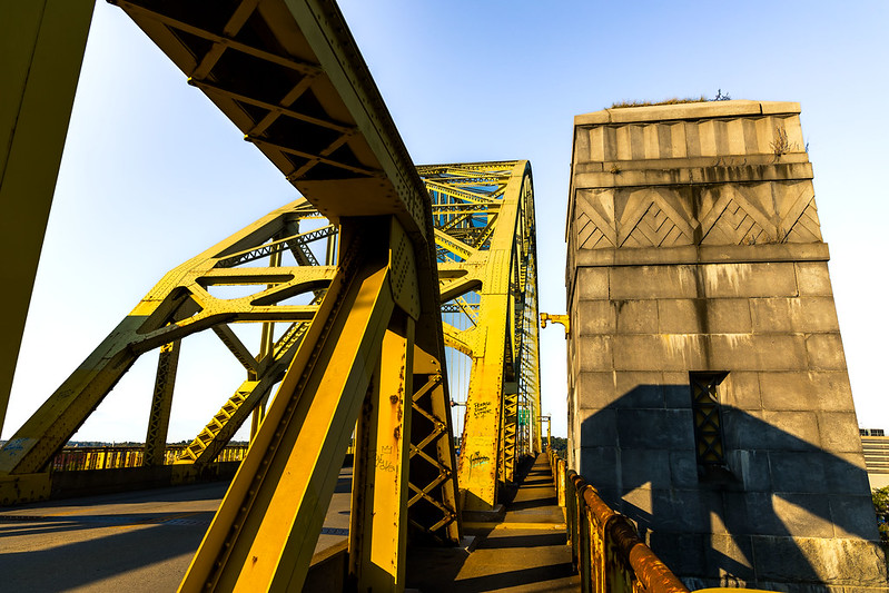
West End Bridge’s pedestrian pathway here in Pittsburgh had pulled my attentions upon itself, and mainly so for several exciting points of view which are found on its south eastern terminus. The bridge’s history was summarized in a prior post, here at Newtown Pentacle. A humble narrator plans on returning here, in the early morning hours, sometime soon for a sunrise session.
Additionally, one encountered a set of ‘Bernie Holes’ cut into the fencing where the bridge overflies the CSX Pittsburgh subdivision tracks. Nothing like a Bernie hole.
For those of you who haven’t been with me from the start, my dearly departed friend Bernard Ente was a devotee of the railroad world, and my mentor at the start of the whole Newtown Creek thing. Bernie would cut fence holes just big enough to stick a lens through at several photogenic spots along Newtown Creek, and all over Western Queens, to facilitate his art. Those of us who were fortunate enough to be in his circle refer to these artifacts of his time with us as ‘Bernie Holes.’ I doubt these are his, of course, but i call them ‘Bernie Holes’ nevertheless.
– photo by Mitch Waxman
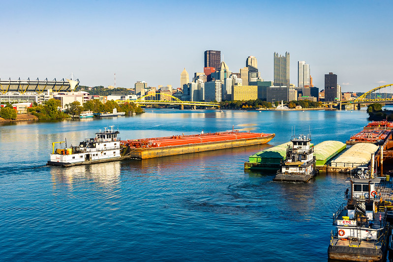
Bernie also introduced me to the NY Harbor community, where I was infected by a real appreciation of tugboats and the importance of the towing industry. A Towing outfit, here in Pittsburgh, is based out of a spot nearby the West End Bridge. Observationally, they mainly move fuel and mineral barges. There’s another set of these docks further east on the Monongahela River, nearby the Edgar Thomson steel mill.
Unfortunately, there doesn’t seem to be any mechanism here for interaction between the tug or tow boats and the freight rail which is commonly witnessed as crossing through the city. Personally, I also find it odd that there isn’t a ferry system in Pittsburgh given the dense population centers stacked up on the shorelines of the 3 rivers.
– photo by Mitch Waxman
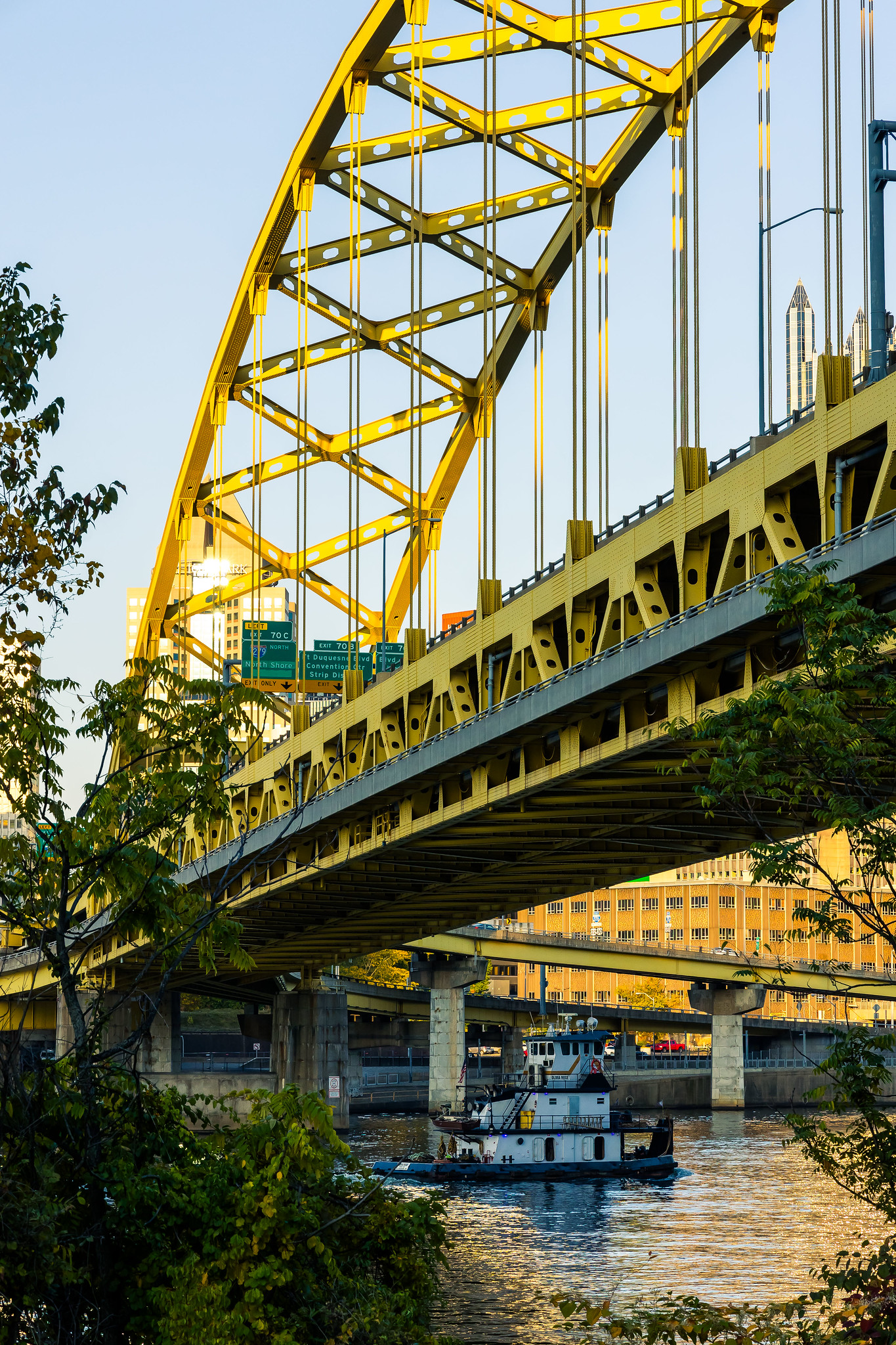
After leaving the West End Bridge, one continued along the Monongahela shoreline and the river ‘rail to trail’ pathway. It’s actually a bit scary, getting from ‘A’ to ‘B,’ but I’m not the timid type and would often scuttle along roadways in NYC that were far more dangerous for pedestrians. You ever walk the Astoria Boulevard fenceline of St. Michael’s Cemetery between 49th & 77th streets? Brrr.
That’s the Fort Pitt bridge which that boat is navigating under.
Back tomorrow with something different, at this – your Newtown Pentacle.
“follow” me on Twitter- @newtownpentacle
Buy a book!
“In the Shadows at Newtown Creek,” an 88 page softcover 8.5×11 magazine format photo book by Mitch Waxman, is now on sale at blurb.com for $30.
West End Bridge, over the Ohio River
Tuesday

– photo by Mitch Waxman
There’s a steel tied arch bridge near the center of Pittsburgh, one which spans the very mouth of the Ohio River (formed up by the convergence of the Allegheny and Monongahela Rivers), and it’s called the West End Bridge. West End Bridge’s construction was declared as accomplished in 1932, and the thing was built by Pittsburgh’s own American Bridge Company (steel and span) and the Foundation Company (foundation and masonry piers). West End Bridge was originally just under 2,000 feet long.
After a sprucing up and redesign in the 1990’s, which saw the addition of pedestrian and bike lanes, as well as the removal of several vehicle approach ramps on its northern side, the West End Bridge was and is 1,310 feet long.
There’s 66 feet of clearance over the water, it’s 58 feet wide in totality, and the bridge carries 4 lanes of traffic through a 40 foot space. West End Bridge is a challenging and unforgiving span to drive over, I would mention, given how narrow the travel lanes are. There’s scrapes and automotive paint residue all over the lane facing concrete superstructure of the thing, as it’s really easy to screw up and misjudge where your car is in relation to the structure when driving over it.
Additionally, like many of Pittsburgh’s bridges, you need to be in the correct lane when entering the crossing in order to access the local streets or highway interchanges on the exit side, something which you’re just supposed to know intuitively. Pittsburgh is all about ‘vernacular.’

– photo by Mitch Waxman
West End Bridge connects the ‘South Hills’ communities to Pittsburgh’s quite urban North Side areas in the annexed ‘Allegheny City’ area, bypassing the congested triangular downtown area.
When exiting the bridge on the south side, you can continue southeast onto an arterial road called Saw Mill Run Blvd., which leads out into the suburban sprawl of the South Hills, or make turns either east or west to access the local streets along the Monongahela and Ohio rivers.
On the northern side of West End Bridge, one lane leads into Pittsburgh’s North Side areas, specifically the ‘Chateau’ neighborhood, and the Mexican War Streets zone. There’s also an interchange on the north side which offers access to local and state highways which ultimately connect to the interstate roads that snake along the Ohio River, or head easterly towards a different set of suburbs after moving through the City. It’s all quite complicated.
Pictured is the pedestrian path, which was actually offered quite an interesting walk. I was the sole occupant on this pathway, which sort of describes my entire existence when you get down to it.

– photo by Mitch Waxman
My interest in the thing had become piqued during the many back and forth trips to the Allegheny General Hospital, on the North Side, for Our Lady of the Pentacle’s medical procedures. It provides an interesting point of view for several ‘hard to reach’ – on foot – parts of Pittsburgh. There are other ‘primary’ crossings which receive far more traffic that accomplish the same function – the Fort Pitt and Fort Duquesne bridges – but there you are.
For an ‘eye in the sky’ overview of what West End Bridge looks like, and its relationship to the larger city it serves, check out any of the posts offered here from the West End Overlook Park.
Back tomorrow with more.
“follow” me on Twitter- @newtownpentacle
Buy a book!
“In the Shadows at Newtown Creek,” an 88 page softcover 8.5×11 magazine format photo book by Mitch Waxman, is now on sale at blurb.com for $30.
Stretching my legs in Pittsburgh
Monday

– photo by Mitch Waxman
The shot above was captured from the top floor of a hospital parking garage, here in Pittsburgh. A humble narrator had just dropped Our Lady of the Pentacle off for her medical procedure, early in the morning on a cloud struck day. I’d be returning here about six hours later to gather her up and bring her back home, then spent a good week or so trying to shield her from the necessities of life, and the affections of Moe the Dog. The second of two such intervals, responsibility at home precluded one from doing much else. Exigency, it affects us all.
Sleeping was my main goal during this interval, and my personal exercise schedule suffered, which resulted in a creeping bodily stiffness and a sound not unlike crushing handfuls of popcorn emerging from the knees, while walking up and down stairs. After receiving the ‘all clear’ from her medical professionals, Our Lady insisted that I get the hell out of the house and go ‘do my thing.’

– photo by Mitch Waxman
One rode the T light rail from HQ to the end of the line on Pittsburgh’s North Side, an elevated station across the street from the site of pilgrimage and worship for the Yinzers – a sports ball stadium wherein dwell the Pittsburgh Steelers. That is Acrisure, formerly Heinz, Stadium. The Pittsburgh people call it Heinz, not Acrisure.
My plan for the afternoon was to ease into the walk, but to also include as many flights of stairs into the equation as possible. Ligaments, tendons, and joints – they all formed up into an internal rhythm section. My headphones were plugged into the appropriate orifices, and I was listening to a playlist of Black Sabbath albums.

– photo by Mitch Waxman
The path I had chosen for the day was informed by the several hospital trips we had made in the prior three weeks by car, and the bridge we drive over in this pursuit. Ultimately, I’d be riding the T back home at the end of the walk, which I’d pick up at the first stop it makes in the central zone of Pittsburgh, at the Station Square stop. It was lovely out, with Pittsburgh displaying an uncharacteristically clear sky, not macerated with dynamic banks of cloud.
It was ‘shorts and a sweatshirt’ weather, which is my favorite sort of atmosphere. For one reason or another I was drawn into using my zoom lens at its widest setting – 24mm – for much of the first half of the walk.
Come with? More tomorrow at your Newtown Pentacle.
“follow” me on Twitter- @newtownpentacle
Buy a book!
“In the Shadows at Newtown Creek,” an 88 page softcover 8.5×11 magazine format photo book by Mitch Waxman, is now on sale at blurb.com for $30.
Rear View Mirror
Friday

– photo by Mitch Waxman
A humble narrator is stretched a bit thin for content at the moment, given that most of the last month has been consumed by a medical drama experienced by Our Lady of the Pentacle. She’s doing great, after an elective but necessary set of procedures, although I don’t want to puncture her privacy by talking specifically about it here. She suffers enough, my bride, via her husband’s ‘open book’ mannerisms and his incessancy.
Today’s post includes shots which didn’t make it into the daily posts over the last few weeks. Pictured above is the driver’s side POV from the Mobile Oppression Platform, gazing back at a massive traffic jam I found myself trapped in one afternoon after a horrific vehicle collision which occurred about a mile ahead of this position, on a road called Liberty.

– photo by Mitch Waxman
Since shooting this series of shots of CSX trains rolling past that brewery I like to carouse at, there has been little opportunity for such hedonist pursuit. There’s a whole series of train shots coming at you in the next couple of weeks, many gathered in the short intervals of Our Lady’s Doctor’s appointments.
Moe the dog has been utterly confused by all of this unfamiliar activity, as the world has not been explicitly revolving around his constant need for fun, play, and tiny mammal terrorizing. It’s been a 7 a.m. to midnight kind of deal for me, as you literally can’t take your eyes off of him lest he start chewing on the Declaration of Independence or continue with his attempts to commit Squirrel genocide one bite at a time.

– photo by Mitch Waxman
I’ve also been uncharacteristically static, not getting my exercises in. All of the internally lubricated parts have stiffened and my knees have started making popcorn sounds when I’m walking up stairs. Luckily, Our Lady has received a cautioned ‘All Clear’ from the Docs and I can soon resume my peregrinations again.
The shot above depicts the Saw Mill Run waterway running through a narrow st the oft mentioned, and nearby to HQ ,‘Seldom Seen Greenway’ trail.

– photo by Mitch Waxman
Before all the drama began, during a visit to the nearby community of Homestead, this absolute unit of a church caught my eye just as the burning thermonuclear eye of god itself was setting. Can’t tell you much, or in fact anything, about it other than it was quite stout.
I’ll be back, and hopefully will be able to get inside of it for a lookie-loo.

– photo by Mitch Waxman
One remains fascinated by the T light rail here in Pittsburgh. Can’t tell you why, except to say that street cars are something truly novel to me. You can take the boy away from the subway, I guess, but…
This one had just dropped me off in the Dormont section of Pittsburgh.

– photo by Mitch Waxman
Another CSX unit rounding the bend nearby that brewery on the South Side which I’ve been attending, this one from either late August or early September, is pictured above. I cannot for the life of me figure out the schedule these companies abide by. Sometimes there will be three or four trains in an hour, whereas others you can sit there for three hours and nada. At least there’s beer. The Norfolk Southern people seem a whole lot busier here in Pittsburgh, and you’ll see a few examples of that in the coming weeks.
Anyway, the interval of staying at HQ to care for a recuperating Our Lady of the Pentacle seems to be at an end. She’s once again whirling, ever whirling. Back to the streets for me, and the odd out of town day trip every now and again.
Back next week with something different at this – your Newtown Pentacle.
“follow” me on Twitter- @newtownpentacle
Buy a book!
“In the Shadows at Newtown Creek,” an 88 page softcover 8.5×11 magazine format photo book by Mitch Waxman, is now on sale at blurb.com for $30.
Youghiogheny River Lake
Tuesday

– photo by Mitch Waxman
In 1806, the National Road was conceived and funded by the United States’ first President and Congress with the goal of providing an east west route out of Washington D.C., to enable westward expansion, trade, and travel. Today, it’s called Route 40 and it’s a part of the Interstate Highway system, which incorporates several local roads into its path. After visiting the Great Cross in Pennsylvania’s Jumonville (described yesterday), on a day trip out of Pittsburgh, a humble narrator piloted his Mobile Oppression Platform into the corduroy landscapes of the Laurel Highlands. Along the way, in a mist choked ‘hollow,’ the 1944 vintage Youghiogheny River Lake was encountered. I felt the need to pull off the National Road and get a few shots of the lake. That’s the bridge which Route 40 rides across it, in the shot above.
There was a scheduled destination which I was trying to make, in Western Maryland, but as always – I had left HQ in Pittsburgh early and built time into the schedule for moments of serendipity.

– photo by Mitch Waxman
I didn’t venture too far from my route, and these shots were gathered in the parking lot of a recreational marina along Route 40, which sat on a small prominence overlooking the water. The Youghiogheny River is dammed nearby, by a United States Army Corps of Engineers installation that provides flood control, and is also a hydroelectric generating station which adds 12 megawatts of power to the electrical grid.
The Youghiogheny River is a tributary of the Monongahela River, which starts its southeastern journey away from ‘the Mon’ back in the Pittsburgh satellite city of McKeesport. The river is 132 miles long, and the ‘Yough’s’ drainage hinterlands ultimately flow into a watershed feeding into the somewhat distant Mississippi River. There’s a huge tourism and sport fishing industry here at the lake, which is also used as a drinking water resovoir, and the waterfront here draws about a million visitors a year to an otherwise quite rural area.

– photo by Mitch Waxman
While I was shooting these photos, a few codgers were getting ready to lower their boats into the water, off of pickup towed trailers, and they were getting ready to try their luck at harvesting fish. The lake is stocked annually, I’m told, by the USACE and the Pennsylvania Game people with a variety of game species like trout.
This was my first time roaming about in this part of the country, and along the route I encountered something I’ve never witnessed before – National Parklands which were once battlegrounds. In the case of one of these parks, Fort Necessity, the battles occurred before the birth of the United States itself, during the French and Indian War in 1754. Everywhere you go, there’s something ‘George Washington’ related.

– photo by Mitch Waxman
This was largely a scouting mission for me, part of learning about the greater region which Pittsburgh is at the center of. Pittsburgh is a cultural and financial megalopolis separate and distinct from the massive East Coast’s seaboard megalopolis, with New York at its center, or the Great Lakes megalopolis centered around by the zone between Detroit and Chicago. If you’re unfamiliar with the megalopolis concept, here’s a Wikipedia page that sums it up.
I’m making an effort, at the moment, to explore the edges of my new home. I’m using what the local CBS station’s weather people display on their forecast map as one of my guides to map it out. The weather map I see on the news extends into the middle of Ohio, the north side of West Virginia, Pennsylvania’s city of Erie to the north, and to Western Maryland to southeast. The latter is where I was heading on this particular morning.

– photo by Mitch Waxman
Also found along the route to Western Maryland, but much closer to Pittsburgh, is the Laurel Caverns outfit. I remember seeing photos of the caverns on a View-Master disc when I was a little kid, and I’ve always wanted to experience them for myself. That’ll be one of my winter day trips, though. For you youngsters, an analog version of ‘Tik Tok’ travel videos is what View-Master offered several generations before the digital era happened.
This was actually quite a drive. I had started out at about 5 in the morning, with a thermos of coffee, a full bottle of ice water (and a Genoa Salami sandwich) in the car. For vast stretches of the route, the speed limit along this route is quite high, sometimes it was 70 mph. Other sections go through towns and cities, and the speed limit drops as low as 25 mph, or 15 in school zones. Traffic lights pop up here and there as well. I could have gone a bit out of my way and taken the high speed Pennsylvania Turnpike, but then I would have had to pay a bunch of tolls and missed all the cool stuff I saw without gaining a significant advantage in terms of travel time.
As mentioned – scouting for the future, that’s me.

– photo by Mitch Waxman
As is my habit, I had extensively researched the route in advance and had a number of saved locations plugged into Google Maps. At one point, I passed by signage extolling the fact that the Mason Dixon line had just been crossed and I was officially in the ‘South.’
More tomorrow, at this – your Newtown Pentacle.
“follow” me on Twitter- @newtownpentacle
Buy a book!
“In the Shadows at Newtown Creek,” an 88 page softcover 8.5×11 magazine format photo book by Mitch Waxman, is now on sale at blurb.com for $30.


