Archive for the ‘Pennsylvania’ Category
Rain and night in Pittsburgh
Friday
– photo by Mitch Waxman
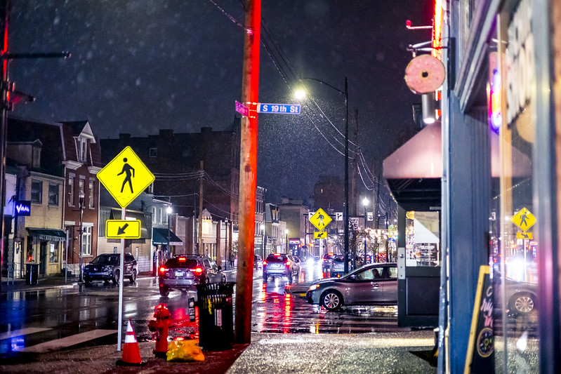
They kind of roll the sidewalks up pretty early here in Pittsburgh, at least by NYC standards. Lifestyle wise, Our Lady of the Pentacle and I don’t go ‘out’ all that much here, and certainly nowhere near as often as used to back in NYC. A recent exception to our rule included a visit to a British style pub and ‘chip shop’ located in the South Side Flats area.
This zone is known for its nightlife, and has a ferocious reputation due the often deadly hijinx of raucous youths on the weekends. Fights, the occasional use of pistols, all that stuff.
There’s a dizzying array of restaurants and bars in this area, including the pub which we were visiting. We had left the car back at home and used a Lyft rideshare to get here. I was planning on having a few pints of draft Guinness, which is a bit harder to find on tap hereabouts than you’d imagine.
– photo by Mitch Waxman
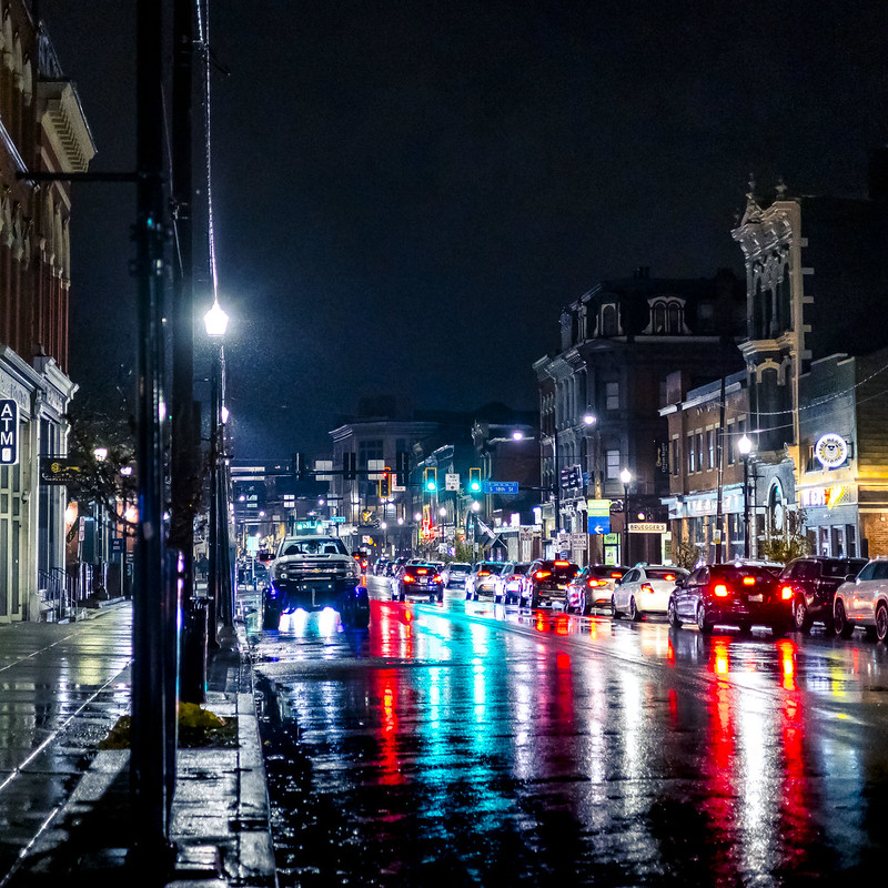
Cities look best when it’s raining, I always say. We had dinner at the chip shot, and my English bride was happy with the menu’s offerings, as it was based on several comfort food dishes from her faraway homeland. Mushy Peas, Scotch Eggs, all that.
Pictured above is East Carson Street, which is the ‘Main Street’ of this section of the Pittsburgh metro, dubbed the South Side Flats.
– photo by Mitch Waxman
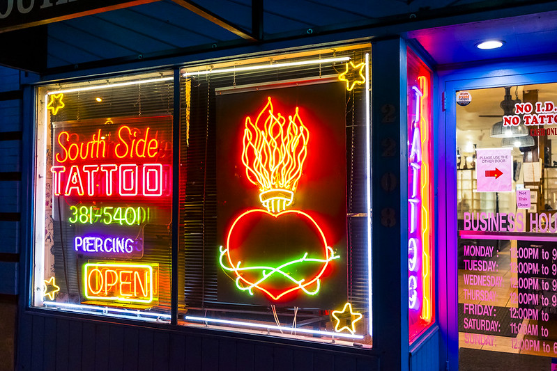
A few nights later, a humble narrator found himself wandering on the same street, and encountered this wonderful neon display in the front window of a tattoo shop. Everybody I encounter here, seemingly, has ‘ink’ and there are many tattoo shops to choose from.
Retail space is comparatively cheap to lease here, meaning that you see a lot of local entrepreneurial energy expressed in the store fronts, rather than the sort of bank machine/big box/franchise activity which dominates the modern retail spaces back in NYC.
Back next week with more from the Paris of Appalachia, at this – your Newtown Pentacle.
“follow” me on Twitter- @newtownpentacle
Buy a book!
“In the Shadows at Newtown Creek,” an 88 page softcover 8.5×11 magazine format photo book by Mitch Waxman, is now on sale at blurb.com for $30.
That train’s ‘Da Bomb’
Thursday

– photo by Mitch Waxman
While a humble narrator was checking out a section of the Montour Trail in Pennsylvania’s Cecil Township, a ‘rail to trail’ public space which follows the right of way once enjoyed by the now defunct Montour Railroad, the still active rail tracks which mirror the trail’s path suddenly sprang to life.
That’s the Wheeling & Lake Erie RR’s #6353 pictured above. It’s an EMD SD40-2 model locomotive, built sometime between 1972-1989 when the model was in general production and apparently it was originally built for the Burlington Northern RR.

– photo by Mitch Waxman
Part of my mission here at the trail was to find fresh ground for Moe the Dog to tear across, in pursuance of bleeding off some of his boundless puppy energy. The sections of these trails closer to HQ are fairly well populated with people and dogs, both of which Moe is displaying a high amount of reactivity to.
By ‘reactivity,’ I mean that he loses his damn mind and becomes a snarling/snapping icehole that is very difficult to keep under control. This is a problem we’re working on, and have been since he came to live with us, but it’s a real bugbear. Thereby, I’m searching out relatively depopulated areas within a certain driving distance of HQ to take him to, where we can work on his training.
This section of the trail seemed fairly ideal, as the surrounding municipality is fairly small in terms of population. There were certainly other people on the trail, but nowhere near as many as you’d encounter closer to center of Pittsburgh.
– photo by Mitch Waxman
A couple of days later, Our Lady of the Pentacle and myself had packed our four footed problem child into the Mobile Oppression Platform (our car, the MOP) and headed back to this section for a long training walk with the dog. The little monster did fairly well for most of the excursion, but when somebody passed by with a couple of other dogs Moe flipped out. Sigh…
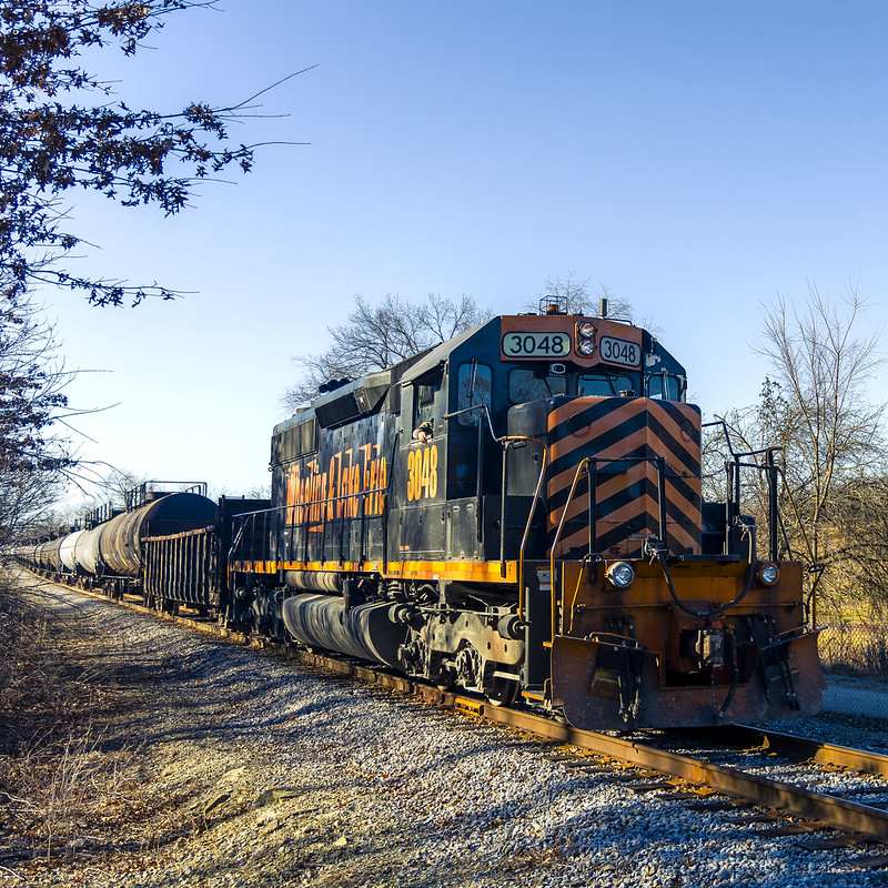
We had just wrestled him back into the MOP, and I was driving us out of the parking lot when I spotted another train approaching from the opposite direction it had been heading towards previously.
That’s Wheeling & Lake Erie #3048. It’s a (rebuilt) EMD SD40-3 model locomotive, but it was originally manufactured sometime between 1966 and 1972 by the General Electric Electro-Motive division and General Motors Diesel.

– photo by Mitch Waxman
W&LE RR were hauling tanker cars designed to carry hazardous cargo, specifically ‘Liquified Petroleum Gas, Non Odorized.’ My friends back in NYC at the Riverkeeper outfit coined the term ‘Bomb Train’ for this sort of cargo. There’s a largish fracking operation nearby this spot, which the W&LE people were likely working for.
When I saw the train a-coming, I reversed the car back into the parking lot, grabbed the camera, and ran across the road prior to the signal arms actuating. Our Lady was comforting Moe back in the MOP while I got busy.

– photo by Mitch Waxman
At the end of the assemblage, there were two locomotives acting as ‘DPU’ or Diesel Distributed Power Units (addendum added post facto, thx to Michael and Daniel for pointing out error). My understanding of this role is that the engines are essentially slaved to the main locomotive at the front of the train and are there to provide extra ‘oomph’ when needed.
That’s W&LE #6992 pictured above. It’s a EMD SD40-2, and quite similar to #6353 in the first shot. It was functioning as a ‘DPU’ or Diesel Power Unit and controlled by wire from the front of the train.

– photo by Mitch Waxman
At the back of the train, W&LE #6386 was also helping the traction operation move along. I guess that it’s the nature of the cargo of some specific about the location, but this train set was moving quite slowly, which is apparently how you move ‘bomb trains’ around for safety’s sake.
#6386 is the same make and model as #6992, an EMD SD40-2.
While learning about trains, I’ve learned a few things. One is that Hobo’s prefer to ride on the DPU units when they’re catching a ride as the interior cabins are climate controlled and there are electrical outlets which can used to charge their phones.
Back tomorrow with something else.
“follow” me on Twitter- @newtownpentacle
Buy a book!
“In the Shadows at Newtown Creek,” an 88 page softcover 8.5×11 magazine format photo book by Mitch Waxman, is now on sale at blurb.com for $30.
Montour at Cecil
Wednesday

– photo by Mitch Waxman
This is another section of the Montour Trail, a subject about which I’ve been talking about quite a lot in recent posts. This one is in or near Cecil Township, a community just north and west of HQ, and about a 25 minute drive for me.
Semi rural, the surrounding municipality has a ‘small town feel’ to it. Their Veterans of Foreign Wars hall has a Sherman Tank sitting in the parking lot, which is something I’ll definitely try to get a couple of shots of, next time I’m up this way. At one point, I saw a horse farm.
As always, I had the camera with me, but didn’t have terribly high hopes for anything photogenic going on. I was going for a short walk, and some alone time with an audiobook.
This time around, it was an audio play dramatizing ‘Night of the Living Dead.’ I had downloaded this one years ago, and it has since become part of audible.com’s collections.

– photo by Mitch Waxman
The Montour Trail, which is a ‘rail to trail’ implementation of public space that takes advantage of an abandoned ‘right of way,’ formerly maintained by a now defunct rail company, is paralleled by an active right of way used by the MarkWest outfit.
MarkWest is, amongst other things, a shale gas recovery company (aka fracking, I’m told), which operates an active railway track that’s right next to the Montour. This track is used to move RR tanker cars full of a material described on the side of the cars as ‘liquified petroleum gas/ non odorized,’ which is newly harvested gas and shale oil that’s being held under extreme pressure for transport.
I didn’t have much hope for seeing a train on this day, I’d mention, but as stated – my purpose here was getting some exercise and to go exploring for a bit.
That trestle above is part of the Markwest short line’s right of way.

– photo by Mitch Waxman
I think that the water flowing alongside the Montour is called ‘Miller’s Run.’ A run, as I understand the term, is defined as being bigger than a creek or stream in terms of water volume. During the spring thaw, these runs can become torrents.
Conventional wisdom, as offered to me by the locals, is that you should think twice before deciding to buy property on a street which has the word ‘run’ in its name, as you’ll inevitably have to deal with flooding sometime in the future.
This surrounding area was positively bucolic, I’d mention, with vast fields of wild vegetation, dressed in their seasonal funerary attire. What looked to me like acres of wetlands were framed in by large plots of residential land, and I even saw a horse farm along the route.

– photo by Mitch Waxman
The Montour Trail splits into separate branches here, and I walked along both of them for a spell. The rail trestle pictured above overflies what looked like the Main Street of a town, whereas in the other direction the trail passes by an active rail switching yard, used by the Markwest people.
After walking over the trestle, I doubled back to the junction between the two branches and headed down the rail oriented one.

– photo by Mitch Waxman
In the distance, I heard a certain sound, even over the headphones which I was listening to that Night of the Living Dead dramatization on, and realization of what was causing the sound saw me quickly reversing my direction so that I could get to a more photogenic spot.
While rapidly scuttling along, I converted the camera’s settings to ‘capture a rapidly moving and enormous object on tracks.’ Actuation of the camera’s many autofocus settings was accomplished, switching from a one shot setting scenario over to one that offered continuous autotracking, with a preference for building sized vehicles.
The engine rumble, and it began to manifest itself long before I heard a ‘steel on steel, worst sound around’ high pitched squeal.

– photo by Mitch Waxman
Lucky, lucky narrator. Choo-Choo’s.
More on that tomorrow.
“follow” me on Twitter- @newtownpentacle
Buy a book!
“In the Shadows at Newtown Creek,” an 88 page softcover 8.5×11 magazine format photo book by Mitch Waxman, is now on sale at blurb.com for $30.
Montour at South Hills
Tuesday

– photo by Mitch Waxman
After walking on a section of the Montour Trail over in Library PA, I drove over to another link in the trail’s chain found in the neighboring community of South Hills. Deeply suburban, this is an absolutely lovely section of the Pittsburgh Metropolitan Area which often reminds one of the setting for a Disney movie.
I parked the Mobile Oppression Platform (MOP) at the Montour’s parking lot, and since I still had a bit of daylight and ‘some gas in my tank,’ decided to walk off another couple of miles. Ultimately, this day was originally scheduled as a ‘short walk,’ but two of my short walks ended up making a ‘long walk.’
I’m all ‘effed up.

– photo by Mitch Waxman
As mentioned, the community of South Hills is lovely. Picturesque homes, sitting on manicured and large properties, are everywhere. The architecture of these residential buildings are disturbingly heterogeneous but in their variety you can observe about sixty to seventy years worth of real estate development and architectural experimentation in the private home sector.
Interesting, I say.
The Montour Trail runs in a trench of sorts here, with earthen berms forming the trench’s walls in some spots whereas others are cuts in the rocky hillsides. In other flatter areas, there’s a tall fence and somebody’s back yard is on the other side of it. There’s lots of ‘posted’ and ‘keep out’ and ‘no trespassing’ signs in these sections.

– photo by Mitch Waxman
It was actually a bit of a chore, getting a clean shot of this section of the trail without any people in frame, as dozens of the local humans were using it to recreate. These trails are really embraced by the communities they snake through, in my observation.
I can’t help but be bitter about my Montauk Cutoff experiences back in Long Island City, both for the pie in the sky planning process insisted on by my fellows (which at one point involved human waste composting), and by the absolute obstinacy and stalling of the MTA. Imagine that one coming true, in LIC, without me driving the process along by sheer force of will?
The rail to trail thing is implemented in such a positive manner here, and embraced by both government and constituent. Win.

– photo by Mitch Waxman
I reached my turn around point, and started back towards the parking lot where the MOP awaited me. Along the way, I spotted the contrails of a jet and couldn’t help myself from getting a little artsy fartsy with the framing in the shot above.
As has become my habit, I was also auditing the location for future visits by Moe the Dog. Moe’s big problem at the moment is aggressive reactivity to other dogs, and as this section of the Montour Trail was actively being used for dog walking, it’s kind of a ‘no go.’
We need deserted areas shunned by man and beast alike, Moe and I.

– photo by Mitch Waxman
Before I got back behind the wheel of the car for the drive back to HQ, I poked my head into a small burying ground directly across the street, the St. Vladimir Ukrainian Cemetery. I took a couple of pictures, but the cemetery was small, the headstones were largely modern, and there wasn’t anything ‘monumental’ there which drew me in other than the iron work of the fencing and a large steel (or maybe zinc/aluminum) cruciform.
There’s graveyards like this one all over the place here in Western Pennsylvania, hosting a few dozen interments marked with modest monuments. The community developed around these cemeteries which were originally on farm land, and you’ll see suburban houses and commercial buildings literally right next door to the graveyards.
All part of the milieu, I guess.

– photo by Mitch Waxman
Back in Dormont, on my way back to HQ, and I felt compelled to pull the MOP over and grab a shot of the wonderful lighting on offer from the late afternoon sun. HQ is at the bottom of this steep hill.
Yes, those are brick pavers on the street. The pavers, rather than asphalt are a combination of historic preservation and practicality here in Pittsburgh. With hills this steep, you want some extra ‘tooth’ for car tires to bite into, especially during rainstorms and during the winter months. At the bottom of the hill, it turns back into regular asphalt.
Back tomorrow.
“follow” me on Twitter- @newtownpentacle
Buy a book!
“In the Shadows at Newtown Creek,” an 88 page softcover 8.5×11 magazine format photo book by Mitch Waxman, is now on sale at blurb.com for $30.
Montour at Library
Monday

– photo by Mitch Waxman
Another ‘short walk day’ found me scuttling down a section of the Montour Trail that I hadn’t visited yet, here in Pittsburgh, this time it was in the South Hills town of Library.
As you may have guessed by now, I’m really leaning into the exercise at the moment. I’ve always walked a lot, but that was in New York where you could walk on a mostly flat plane for dozens of miles in any direction. The terrain of Pittsburgh is challenging, to say the least, and I’m walking about 20% less in terms of miles than I used to according to the phone’s health app.
Use it or lose it, regarding internally lubricated parts…
Luckily, rail’s road grading standard is one foot of elevation per every hundred feet, and since the historic Montour Railroad’s ‘right of way’ has been ‘nationalized’ and turned into a bike and pedestrian trail it’s easy to rectify all that.
Several sections of the Montour Trail have been visited in the single year that I’ve lived here, click here to see those posts in reverse chronological order.
My gameplan for this explorative process on the Montour has been to pick a parking spot and then walk around 5 miles in one direction and then double back to where I parked the car (the trail’s ‘org’ offers parking lots at some of the trailheads).

– photo by Mitch Waxman
That’s the Library Trestle, a 506 foot long former rail bridge which carries the Montour Trail over a primary arterial street called ‘Library Road.’ Said road varies in shape, width, and purpose over its travel route.
Midway along Library Road, quite near the massive recreational center called South Park, it’s what traffic engineers would call a ‘Stroad.’ Wide, multi laned, with strip malls and shopping centers populating either side. Stroads often omit sidewalks in favor of having pedestrians walk in the store’s parking lots instead. Here in Library, this stroad transmogrifies into a single travel and parking lane, in each direction, and it functions as a sort of ‘main street.’
The real estate in the surrounding towns, whose road system branches off of Library Road, is fairly expensive and quite suburban in character.
There is a T station in Library, however, which is accompanied by a large ‘park and ride’ lot that is seemingly free to use. I didn’t pay anything, at least, when I parked the Mobile Oppression Platform there for this walk. I looked around for some sort of kiosk, couldn’t find one, so… free.

– photo by Mitch Waxman
When I was walking across the Trestle, a T Silver Line came rolling by below. As you can see, the streetcar service uses a catenary system to power its operation.
The waterway you see in the top left of the shot, to my knowledge, is called Montour Run.

– photo by Mitch Waxman
This time around, the audiobook I was listening to was a reading of Bram Stoker’s Dracula as narrated by Christopher Lee.
It really fed into a creepy mood I was enjoying. The great thing about these trails is that you’re often totally alone and isolated from surrounding communities. Sure – a bike rider will zip through, or you’ll cross another walker along the path, but the isolation can be glorious.
Surrounding the trails, there’s usually a bit of that massive urban forest which Pittsburgh hosts, but just as often you get to peek into unknown neighborhoods and observe ways of life alien to your own.
Gotta say, it’s weird seeing the Confederate flag being flown, especially so in Pennsylvania, where a lot of that conflict played out.
Y’know, many horror movies are set in Western Pennsylvania, not just Night of the Living Dead. Something about the place is inherently spooky, and especially so at night.

– photo by Mitch Waxman
I had walked through several communities on the Montour that particular day. I only know this because they set out ‘welcome to’ signs along the trail. I had doubled back by this point of the walk, having walked the trail about three miles or so. With the turnaround, it boiled down to about six miles which I walked quicker than usual down – about 3.2 mph, according to the fore mentioned health app.
Every walk has to have a ‘turn around’ point here, either to get back to the car or to the T. It’s not like NYC where I could walk to the Gowanus from Astoria, and then just hop on the G to get back to LIC.
That’s (as I still believe it to be) Montour Run again.

– photo by Mitch Waxman
I hung around on the trestle for a bit, hoping that I’d get another ‘T from above’ shot, which eventually paid off.
This wasn’t the only section of the Montour Trail which I’d end up taking a walk along this particular week. There’s reasons I’m leaning into the exercise as hard as I am at the moment, which aren’t dire, but mainly revolve around toning up the musculature and dropping a few pounds by revving up the ‘old’ metabolism.
No… I literally mean ‘old’ here, and not colloquially. I’m at that age where men begin to lose muscle, and it’s a ‘use it or lose it’ type scenario regarding staying active.
Back tomorrow.
“follow” me on Twitter- @newtownpentacle
Buy a book!
“In the Shadows at Newtown Creek,” an 88 page softcover 8.5×11 magazine format photo book by Mitch Waxman, is now on sale at blurb.com for $30.


